Bridge Statistics for LaGrange, Georgia (GA)
Condition, Traffic, Stress, Structural Evaluation, Project Costs
- National Bridge Inventory (NBI) Statistics
- 115Number of bridges
- 1,699ft / 518mTotal length
- $207,586,000Total costs
- 1,138,270Total average daily traffic
- 80,239Total average daily truck traffic
- National Bridge Inventory (NBI) Registered Bridges for LaGrange
- No street view available for this location
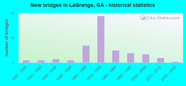
- New bridges - historical statistics
- 21920-1929
- 21930-1939
- 31940-1949
- 21950-1959
- 141960-1969
- 381970-1979
- 101980-1989
- 81990-1999
- 72000-2009
- 42010-2019
- 12020-2022

- Reconstructed bridges - Historical Statistics
- 11950-1959
- 11960-1969
- 11970-1979
- 11980-1989
- 41990-1999


- Bridge Condition - Deck
- 7.5%Very good
- 82.1%Good
- 9.0%Satisfactory
- 1.5%Fair

- Bridge Condition - Superstructure
- 28.4%Very good
- 70.1%Good
- 1.5%Satisfactory

- Bridge Condition - Substructure
- 4.5%Very good
- 85.1%Good
- 6.0%Satisfactory
- 1.5%Fair
- 1.5%Poor
- 1.5%Critical

- Bridge Condition - Channel
- 5.3%Excellent
- 40.4%Very good
- 40.4%Good
- 8.8%Satisfactory
- 5.3%Fair

- Bridge Condition - Culverts
- 75.0%Good
- 25.0%Satisfactory
Find on map >> Show street view
Structure Number: 2855063, Location: 3.9 MI N OF LA GRANGE (Lat: 33.096767, Lng: -85.030631), Route carried "on" structure: US 27, Year Built: 2005, Status: Open, Structure Length: 10.91m (35.79ft), Average Daily Traffic: 7,350 (year 2012), Truck Traffic: 11%, Average Future Daily Traffic: 11,025 (year 2032), Design Load: HS 20+Mod, Features Intersected: BEECH CREEK
Minimum Vertical Clearance: 30+ m (98+ ft), Kilometerpoint: 33.796, Lanes on structure: 2, Base Highway Network: Yes, Owner: State Highway Agency, Approaching Roadway Width: 7.3m (24.0ft), Skew: 10 degrees, Material/Design: Prestressed concrete, Design/Construction: Stringer/Multi-beam, Number Of Spans In Main Unit: 4, Length of Maximum Span: 31.1m (102.0ft), Curb-To-Curb Width: 11.4m (37.4ft), Out-to-Out Width: 12.4m (40.7ft)
Condition: Deck: Good, Superstructure: Good, Substructure: Good, Channel: Very good, Operating Rating: 65.3 metric tons, Method Used To Determine Operating Rating: Load Factor (LF), Inventory Rating: 37.1 metric tons, Method Used To Determine Inventory Rating: Load Factor (LF), Structural Evaluation: Better than present minimum criteria, Deck Geometry: Equal to present minimum criteria, Waterway Adequacy: Superior to present desirable criteria, Approach Roadway Alignment: Equal to present desirable criteria, Designated Inspection Frequency: Every 24 months, Underwater Inspection Frequency: Every 60 months, Inspection Date: September 2021, Underwater Inspection Date: July 2019, Bridge Improvement Cost: $1,399,000, Roadway Improvement Cost: $140,000, Total Project Cost: $2,098,000, Deck Structure Type: Concrete Cast-file-Place, Wearing Surface/Protective System: Wearing Surface: Epoxy Overlay
Find on map >> Show street view
Structure Number: 2855064, Location: 7.2 MI N OF LA GRANGE (Lat: 33.144217, Lng: -85.039131), Route carried "on" structure: US 27, Year Built: 2004, Status: Open, Structure Length: 5.49m (18.01ft), Average Daily Traffic: 6,580 (year 2012), Truck Traffic: 1%, Average Future Daily Traffic: 9,870 (year 2032), Design Load: HS 20+Mod, Features Intersected: WEST POINT LAKE-FISH CR.
Minimum Vertical Clearance: 30+ m (98+ ft), Kilometerpoint: 40.234, Lanes on structure: 2, Base Highway Network: Yes, Owner: State Highway Agency, Approaching Roadway Width: 9.8m (32.2ft), Skew: 12 degrees, Material/Design: Prestressed concrete, Design/Construction: Stringer/Multi-beam, Number Of Spans In Main Unit: 3, Length of Maximum Span: 18.3m (60.0ft), Curb-To-Curb Width: 11.4m (37.4ft), Out-to-Out Width: 12.4m (40.7ft)
Condition: Deck: Very good, Superstructure: Very good, Substructure: Good, Channel: Very good, Operating Rating: 50.8 metric tons, Method Used To Determine Operating Rating: Load Factor (LF), Inventory Rating: 26.3 metric tons, Method Used To Determine Inventory Rating: Load Factor (LF), Structural Evaluation: Equal to present minimum criteria, Deck Geometry: Equal to present minimum criteria, Waterway Adequacy: Superior to present desirable criteria, Approach Roadway Alignment: Equal to present desirable criteria, Designated Inspection Frequency: Every 24 months, Inspection Date: September 2021, Bridge Improvement Cost: $703,000, Roadway Improvement Cost: $70,000, Total Project Cost: $1,055,000, Deck Structure Type: Concrete Cast-file-Place, Wearing Surface/Protective System: Wearing Surface: Epoxy Overlay
Find on map >> Show street view
Structure Number: 2855065, Location: 4.9 MI N OF LA GRANGE (Lat: 33.111281, Lng: -85.037881), Route carried "on" structure: US 27, Year Built: 2005, Status: Open, Structure Length: 8.99m (29.49ft), Average Daily Traffic: 7,350 (year 2012), Truck Traffic: 11%, Average Future Daily Traffic: 11,025 (year 2032), Design Load: HS 20+Mod, Features Intersected: YELLOW JACKET CREEK
Minimum Vertical Clearance: 30+ m (98+ ft), Kilometerpoint: 35.406, Lanes on structure: 2, Base Highway Network: Yes, Owner: State Highway Agency, Approaching Roadway Width: 8.5m (27.9ft), Skew: 10 degrees, Material/Design: Prestressed concrete, Design/Construction: Stringer/Multi-beam, Number Of Spans In Main Unit: 3, Length of Maximum Span: 29.9m (98.1ft), Curb-To-Curb Width: 11.4m (37.4ft), Out-to-Out Width: 12.4m (40.7ft)
Condition: Deck: Good, Superstructure: Good, Substructure: Good, Channel: Very good, Operating Rating: 75.2 metric tons, Method Used To Determine Operating Rating: Load Factor (LF), Inventory Rating: 39.0 metric tons, Method Used To Determine Inventory Rating: Load Factor (LF), Structural Evaluation: Better than present minimum criteria, Deck Geometry: Equal to present minimum criteria, Waterway Adequacy: Equal to present desirable criteria, Approach Roadway Alignment: Equal to present desirable criteria, Designated Inspection Frequency: Every 24 months, Underwater Inspection Frequency: Every 60 months, Inspection Date: September 2021, Underwater Inspection Date: September 2019, Bridge Improvement Cost: $1,153,000, Roadway Improvement Cost: $115,000, Total Project Cost: $1,729,000, Deck Structure Type: Concrete Cast-file-Place, Wearing Surface/Protective System: Wearing Surface: Epoxy Overlay
Find on map >> Show street view
Structure Number: 2855066, Location: IN WEST LAGRANGE (Lat: 33.032631, Lng: -85.049072), Route carried "on" structure: City street 2904, Year Built: 2006, Status: Open, Structure Length: 1.55m (5.09ft), Average Daily Traffic: 710 (year 2012), Truck Traffic: 1%, Average Future Daily Traffic: 1,065 (year 2032), Design Load: HS 20+Mod, Features Intersected: CSX RAILROAD, Facility Carried by Structure: JEFFERSON STREET
Minimum Vertical Clearance: 30+ m (98+ ft), Kilometerpoint: 0.000, Lanes on structure: 2, Base Highway Network: Yes, Owner: City or Municipal Highway Agency, Approaching Roadway Width: 8.5m (27.9ft), Skew: 1 degrees, Material/Design: Prestressed concrete, Design/Construction: Frame, Number Of Spans In Main Unit: 1, Length of Maximum Span: 15.5m (50.9ft), Curb or Sidewalk Widths: Left: 1.8m (5.9ft), Right: 1.8m (5.9ft), Curb-To-Curb Width: 8.5m (27.9ft), Out-to-Out Width: 19.5m (64.0ft)
Condition: Deck: Very good, Superstructure: Very good, Substructure: Very good, Operating Rating: 55.3 metric tons, Method Used To Determine Operating Rating: Allowable Stress (AS), Inventory Rating: 32.6 metric tons, Method Used To Determine Inventory Rating: Allowable Stress (AS), Structural Evaluation: Equal to present desirable criteria, Deck Geometry: Somewhat better than minimum adequacy, Underclear: Superior to present desirable criteria, Approach Roadway Alignment: Equal to present desirable criteria, Designated Inspection Frequency: Every 24 months, Inspection Date: December 2021, Bridge Improvement Cost: $199,000, Roadway Improvement Cost: $20,000, Total Project Cost: $299,000, Deck Structure Type: Concrete Precast Panels, Wearing Surface/Protective System: Wearing Surface: Bituminous
Find on map >> Show street view
Structure Number: 2855074, Location: SOUTH SIDE OF LAGRANGE (Lat: 32.989600, Lng: -85.059628), Route carried "on" structure: City street 304, Year Built: 2009, Status: Open, Structure Length: 27.37m (89.80ft), Average Daily Traffic: 17,000 (year 2010), Truck Traffic: 2%, Average Future Daily Traffic: 28,000 (year 2031), Design Load: HS 20+Mod, Features Intersected: BLUE JOHN CREEK, Facility Carried by Structure: PEGASUS PARKWAY
Minimum Vertical Clearance: 30+ m (98+ ft), Kilometerpoint: 1.609, Lanes on structure: 2, Base Highway Network: Yes, Owner: City or Municipal Highway Agency, Approaching Roadway Width: 11.3m (37.1ft), Skew: 2 degrees, Material/Design: Prestressed concrete, Design/Construction: Stringer/Multi-beam, Number Of Spans In Main Unit: 8, Length of Maximum Span: 37.5m (123.0ft), Curb-To-Curb Width: 12.7m (41.7ft), Out-to-Out Width: 13.8m (45.3ft)
Condition: Deck: Good, Superstructure: Good, Substructure: Good, Channel: Very good, Operating Rating: 63.5 metric tons, Method Used To Determine Operating Rating: Load Factor (LF), Inventory Rating: 25.4 metric tons, Method Used To Determine Inventory Rating: Load Factor (LF), Structural Evaluation: Equal to present minimum criteria, Deck Geometry: Somewhat better than minimum adequacy, Underclear: Better than present minimum criteria, Waterway Adequacy: Superior to present desirable criteria, Approach Roadway Alignment: Equal to present desirable criteria, Designated Inspection Frequency: Every 24 months, Inspection Date: December 2021, Bridge Improvement Cost: $3,509,000, Roadway Improvement Cost: $351,000, Total Project Cost: $5,263,000, Deck Structure Type: Concrete Cast-file-Place
Find on map >> Show street view
Structure Number: 2855075, Location: SOUTH SIDE OF LAGRANGE (Lat: 32.994611, Lng: -85.080500), Route carried "on" structure: City street 304, Year Built: 2011, Status: Open, Structure Length: 0.70m (2.30ft), Average Daily Traffic: 17,000 (year 2011), Truck Traffic: 2%, Average Future Daily Traffic: 28,000 (year 2031), Design Load: HS 20+Mod, Features Intersected: BLUE JOHN CREEK TRIB., Facility Carried by Structure: PEGASUS PARKWAY
Minimum Vertical Clearance: 30+ m (98+ ft), Kilometerpoint: 4.828, Lanes on structure: 2, Base Highway Network: Yes, Owner: City or Municipal Highway Agency, Approaching Roadway Width: 11.0m (36.1ft), Skew: 2 degrees, Material/Design: Concrete, Design/Construction: Culvert, Number Of Spans In Main Unit: 2, Length of Maximum Span: 3.4m (11.2ft)
Condition: Channel: Excellent, Culverts: Good, Operating Rating: 89.8 metric tons, Method Used To Determine Operating Rating: Field evaluation and documented engineering judgment, Inventory Rating: 89.8 metric tons, Method Used To Determine Inventory Rating: Field evaluation and documented engineering judgment, Structural Evaluation: Better than present minimum criteria, Waterway Adequacy: Superior to present desirable criteria, Approach Roadway Alignment: Equal to present desirable criteria, Designated Inspection Frequency: Every 24 months, Inspection Date: November 2021, Bridge Improvement Cost: $90,000, Roadway Improvement Cost: $9,000, Total Project Cost: $135,000
Find on map >> Show street view
Structure Number: 285508, Location: 8 MI S OF LAGRANGE (Lat: 32.918975, Lng: -84.977292), Route carried "on" structure: County highway 2031, Year Built: 2015, Status: Open, Structure Length: 6.58m (21.59ft), Average Daily Traffic: 380 (year 2012), Truck Traffic: 1%, Average Future Daily Traffic: 570 (year 2032), Design Load: HS 20+Mod, Features Intersected: FLAT SHOAL CREEK, Facility Carried by Structure: CR 415 SALEM ROAD
Minimum Vertical Clearance: 30+ m (98+ ft), Kilometerpoint: 6.437, Lanes on structure: 2, Base Highway Network: Yes, Owner: County Highway Agency, Approaching Roadway Width: 5.8m (19.0ft), Material/Design: Steel, Design/Construction: Truss - Thru, Number Of Spans In Main Unit: 1, Number Of Approach Spans: 1, Length of Maximum Span: 43.6m (143.0ft), Curb or Sidewalk Widths: Left: 0.2m (0.7ft), Right: 0.2m (0.7ft), Curb-To-Curb Width: 7.8m (25.6ft), Out-to-Out Width: 8.9m (29.2ft)
Condition: Deck: Good, Superstructure: Very good, Substructure: Good, Channel: Very good, Operating Rating: 38.1 metric tons, Method Used To Determine Operating Rating: Load Factor (LF), Inventory Rating: 22.6 metric tons, Method Used To Determine Inventory Rating: Load Factor (LF), Structural Evaluation: Equal to present minimum criteria, Deck Geometry: Somewhat better than minimum adequacy, Waterway Adequacy: Better than present minimum criteria, Approach Roadway Alignment: Better than present minimum criteria, Length Of Structure Improvement: 7.89m (25.89ft), Designated Inspection Frequency: Every 24 months, Critical Feature Inspection Frequency: Every 12 months, Inspection Date: December 2021, Critical Feature Inspection Date: December 2021, Bridge Improvement Cost: $19,181,000, Roadway Improvement Cost: $1,918,000, Total Project Cost: $28,771,000 ( Estimate for 2016), Deck Structure Type: Concrete Cast-file-Place
Find on map >> Show street view
Structure Number: 2855082, Location: 3 MI E OF LAGRANGE (Lat: 33.025308, Lng: -84.943897), Route carried "on" structure: County highway 226, Year Built: 2018, Status: Open, Structure Length: 2.13m (6.99ft), Average Daily Traffic: 490 (year 2012), Truck Traffic: 1%, Average Future Daily Traffic: 735 (year 2032), Design Load: HS 20+Mod, Features Intersected: LONG CANE CREEK, Facility Carried by Structure: STEWART ROAD
Minimum Vertical Clearance: 30+ m (98+ ft), Kilometerpoint: 1.609, Lanes on structure: 2, Base Highway Network: Yes, Owner: County Highway Agency, Approaching Roadway Width: 7.3m (24.0ft), Material/Design: Prestressed concrete, Design/Construction: Stringer/Multi-beam, Number Of Spans In Main Unit: 1, Length of Maximum Span: 21.3m (69.9ft), Curb-To-Curb Width: 9.8m (32.2ft), Out-to-Out Width: 10.7m (35.1ft)
Condition: Deck: Very good, Superstructure: Very good, Substructure: Very good, Channel: Excellent, Operating Rating: 68.9 metric tons, Method Used To Determine Operating Rating: Load Factor (LF), Inventory Rating: 30.8 metric tons, Method Used To Determine Inventory Rating: Load Factor (LF), Structural Evaluation: Better than present minimum criteria, Deck Geometry: Equal to present minimum criteria, Waterway Adequacy: Equal to present desirable criteria, Approach Roadway Alignment: Better than present minimum criteria, Length Of Structure Improvement: 2.56m (8.40ft), Designated Inspection Frequency: Every 24 months, Inspection Date: November 2021, Bridge Improvement Cost: $6,216,000, Roadway Improvement Cost: $622,000, Total Project Cost: $9,324,000 ( Estimate for 2018), Deck Structure Type: Concrete Precast Panels
Find on map >> Show street view
Structure Number: 2855083, Location: 3 MI SE OF LAGRANGE (Lat: 32.962278, Lng: -84.989969), Route carried "on" structure: County highway 162, Year Built: 2018, Status: Open, Structure Length: 2.08m (6.82ft), Average Daily Traffic: 490 (year 2012), Truck Traffic: 1%, Average Future Daily Traffic: 735 (year 2032), Design Load: HS 20+Mod, Features Intersected: MUD CREEK, Facility Carried by Structure: HUNT ROAD
Minimum Vertical Clearance: 30+ m (98+ ft), Kilometerpoint: 1.609, Lanes on structure: 2, Base Highway Network: Yes, Owner: County Highway Agency, Approaching Roadway Width: 6.1m (20.0ft), Material/Design: Prestressed concrete, Design/Construction: Box Beam or Girders - Multiple, Number Of Spans In Main Unit: 1, Length of Maximum Span: 20.7m (67.9ft), Curb-To-Curb Width: 9.0m (29.5ft), Out-to-Out Width: 10.0m (32.8ft)
Condition: Deck: Very good, Superstructure: Very good, Substructure: Very good, Channel: Excellent, Operating Rating: 75.2 metric tons, Method Used To Determine Operating Rating: Load Factor (LF), Inventory Rating: 43.5 metric tons, Method Used To Determine Inventory Rating: Load Factor (LF), Structural Evaluation: Equal to present desirable criteria, Deck Geometry: Somewhat better than minimum adequacy, Waterway Adequacy: Better than present minimum criteria, Approach Roadway Alignment: Better than present minimum criteria, Length Of Structure Improvement: 2.50m (8.20ft), Designated Inspection Frequency: Every 24 months, Inspection Date: September 2021, Bridge Improvement Cost: $6,068,000, Roadway Improvement Cost: $607,000, Total Project Cost: $9,102,000 ( Estimate for 2017), Deck Structure Type: Concrete Precast Panels
Find on map >> Show street view
Structure Number: 2855085, Location: IN EAST LAGRANGE (Lat: 33.043678, Lng: -85.006839), Route carried "on" structure: City street 2932, Year Built: 2020, Status: Open, Structure Length: 12.98m (42.59ft), Average Daily Traffic: 2,850 (year 2018), Truck Traffic: 3%, Average Future Daily Traffic: 3,450 (year 2040), Design Load: HS 20+Mod, Features Intersected: CSX RAILROAD, Facility Carried by Structure: GREENVILLE STREET
Minimum Vertical Clearance: 30+ m (98+ ft), Kilometerpoint: 1.609, Lanes on structure: 2, Base Highway Network: Yes, Owner: City or Municipal Highway Agency, Approaching Roadway Width: 9.1m (29.9ft), Skew: 1 degrees, Material/Design: Prestressed concrete, Design/Construction: Stringer/Multi-beam, Number Of Spans In Main Unit: 5, Length of Maximum Span: 31.4m (103.0ft), Curb or Sidewalk Widths: Left: 1.7m (5.6ft), Right: 1.7m (5.6ft), Curb-To-Curb Width: 8.5m (27.9ft), Out-to-Out Width: 12.6m (41.3ft)
Condition: Deck: Good, Superstructure: Very good, Substructure: Good, Operating Rating: 63.5 metric tons, Method Used To Determine Operating Rating: Load Factor (LF), Inventory Rating: 39.0 metric tons, Method Used To Determine Inventory Rating: Load Factor (LF), Structural Evaluation: Better than present minimum criteria, Deck Geometry: Meets minimum limits, Underclear: Superior to present desirable criteria, Approach Roadway Alignment: Equal to present desirable criteria, Length Of Structure Improvement: 15.58m (51.12ft), Designated Inspection Frequency: Every 24 months, Inspection Date: September 2021, Other Special Inspection Date: January 2021, Bridge Improvement Cost: $37,814,000, Roadway Improvement Cost: $3,781,000, Total Project Cost: $56,721,000 ( Estimate for 2019), Deck Structure Type: Concrete Cast-file-Place
Find on map >> Show street view
Structure Number: 2850026, Location: 5 MI NE OF LAGRANGE (Lat: 33.051900, Lng: -84.948128), Route carried "under" structure: Interstate 185, Structure Length: 0. m, Average Daily Traffic: 12,400 (year 1998), Truck Traffic: 1%, Features Intersected: SR 29 CONN., Facility Carried by Structure: US 29 CONN.
Minimum Vertical Clearance: 5.10m (16.73ft), Kilometerpoint: 78.858, Lanes on structure: 2, Length of Maximum Span: 0.0m
Find on map >> Show street view
Structure Number: 2850027, Location: 2 MI E OF LAGRANGE (Lat: 33.058172, Lng: -84.950328), Route carried "under" structure: Interstate 85, Structure Length: 0. m, Average Daily Traffic: 27,300 (year 1999), Truck Traffic: 1%, Features Intersected: SR 29 CONN., Facility Carried by Structure: US 29 CONN./ SR 29
Minimum Vertical Clearance: 5.68m (18.64ft), Kilometerpoint: 32.187, Lanes on structure: 1, Length of Maximum Span: 0.0m
Find on map >> Show street view
Structure Number: 2850035, Location: 4.7 MI E OF LAGRANGE (Lat: 33.042569, Lng: -84.951019), Route carried "under" structure: Interstate 185, Structure Length: 0. m, Average Daily Traffic: 12,010 (year 2009), Truck Traffic: 1%, Features Intersected: SR 109 EBL, Facility Carried by Structure: SR 109
Minimum Vertical Clearance: 5.10m (16.73ft), Kilometerpoint: 77.249, Lanes on structure: 2, Length of Maximum Span: 0.0m
Find on map >> Show street view
Structure Number: 2850036, Location: 2 MI E OF LAGRANGE (Lat: 33.042478, Lng: -84.949550), Route carried "under" structure: Interstate 185, Structure Length: 0. m, Average Daily Traffic: 12,010 (year 1999), Truck Traffic: 1%, Features Intersected: SR 109 WBL, Facility Carried by Structure: SR 109
Minimum Vertical Clearance: 5.23m (17.16ft), Kilometerpoint: 77.249, Lanes on structure: 2, Length of Maximum Span: 0.0m
Find on map >> Show street view
Structure Number: 2850044, Location: 1 MI SE OF LAGRANGE (Lat: 32.988919, Lng: -85.029614), Route carried "under" structure: Interstate 85, Structure Length: 0. m, Average Daily Traffic: 23,700 (year 2009), Truck Traffic: 1%, Features Intersected: SR 219, Facility Carried by Structure: SR 219
Minimum Vertical Clearance: 5.71m (18.73ft), Kilometerpoint: 20.921, Lanes on structure: 4, Length of Maximum Span: 0.0m
Find on map >> Show street view
Structure Number: 2850056, Location: 3 MI SW OF LAGRANGE (Lat: 32.960456, Lng: -85.083144), Route carried "under" structure: County highway 99, Structure Length: 0. m, Average Daily Traffic: 630 (year 2009), Truck Traffic: 1%, Features Intersected: I-85 NBL (SR 403), Facility Carried by Structure: I-85 (NBL)
Minimum Vertical Clearance: 4.90m (16.08ft), Kilometerpoint: 6.437, Lanes on structure: 2, Length of Maximum Span: 0.0m
Find on map >> Show street view
Structure Number: 2850057, Location: 3 MI SW OF LAGRANGE (Lat: 32.960578, Lng: -85.083447), Route carried "under" structure: County highway 99, Structure Length: 0. m, Average Daily Traffic: 630 (year 1999), Truck Traffic: 1%, Features Intersected: I-85 SBL (SR 403), Facility Carried by Structure: I-85 (SBL)
Minimum Vertical Clearance: 5.10m (16.73ft), Kilometerpoint: 6.437, Lanes on structure: 2, Length of Maximum Span: 0.0m
Find on map >> Show street view
Structure Number: 285006, Location: .2 MI SE OF LAGRANGE (Lat: 33.000008, Lng: -85.012278), Route carried "under" structure: US 27, Structure Length: 0. m, Average Daily Traffic: 11,250 (year 1999), Truck Traffic: 1%, Features Intersected: I-85 NBL (SR 403), Facility Carried by Structure: I-85 (NBL)
Minimum Vertical Clearance: 5.33m (17.49ft), Kilometerpoint: 22.531, Lanes on structure: 2, Length of Maximum Span: 0.0m
Find on map >> Show street view
Structure Number: 2850061, Location: .2 MI SE OF LAGRANGE (Lat: 33.000228, Lng: -85.012458), Route carried "under" structure: US 27, Structure Length: 0. m, Average Daily Traffic: 14,600 (year 1999), Truck Traffic: 1%, Features Intersected: I-85 SBL (SR 403), Facility Carried by Structure: I-85 (SBL)
Minimum Vertical Clearance: 5.15m (16.90ft), Kilometerpoint: 22.531, Lanes on structure: 2, Length of Maximum Span: 0.0m
Find on map >> Show street view
Structure Number: 2850062, Location: .5 MI SE OF LAGRANGE (Lat: 33.020428, Lng: -84.985989), Route carried "under" structure: City street 2914, Structure Length: 0. m, Average Daily Traffic: 1,290 (year 1999), Truck Traffic: 1%, Features Intersected: I-85 NBL (SR 403), Facility Carried by Structure: I-85 (NBL)
Minimum Vertical Clearance: 5.02m (16.47ft), Kilometerpoint: 3.219, Lanes on structure: 2, Length of Maximum Span: 0.0m
Find on map >> Show street view
Structure Number: 2850063, Location: .5 MI SE OF LAGRANGE (Lat: 33.020519, Lng: -84.986308), Route carried "under" structure: City street 2914, Structure Length: 0. m, Average Daily Traffic: 1,290 (year 1999), Truck Traffic: 1%, Features Intersected: I-85 SBL (SR 403), Facility Carried by Structure: I-85 (SBL)
Minimum Vertical Clearance: 5.63m (18.47ft), Kilometerpoint: 3.219, Lanes on structure: 2, Length of Maximum Span: 0.0m
Find on map >> Show street view
Structure Number: 2850066, Location: EAST EDGE OF LAGRANGE (Lat: 33.042178, Lng: -84.969469), Route carried "under" structure: State highway 109, Structure Length: 0. m, Average Daily Traffic: 10,770 (year 1999), Truck Traffic: 1%, Features Intersected: I-85 NBL (SR 403), Facility Carried by Structure: I-85 (NBL)
Minimum Vertical Clearance: 5.58m (18.31ft), Kilometerpoint: 25.750, Lanes on structure: 3, Length of Maximum Span: 0.0m
Find on map >> Show street view
Structure Number: 2850067, Location: EAST EDGE OF LAGRANGE (Lat: 33.042078, Lng: -84.969939), Route carried "under" structure: State highway 109, Structure Length: 0. m, Average Daily Traffic: 10,770 (year 1999), Truck Traffic: 1%, Features Intersected: I-85 SBL (SR 403), Facility Carried by Structure: I-85 (SBL)
Minimum Vertical Clearance: 6.09m (19.98ft), Kilometerpoint: 25.750, Lanes on structure: 2, Length of Maximum Span: 0.0m
Find on map >> Show street view
Structure Number: 2850085, Location: 2 MI NE OF LAGRANGE (Lat: 33.061608, Lng: -84.945158), Route carried "under" structure: Interstate 85, Structure Length: 0. m, Average Daily Traffic: 27,300 (year 1999), Truck Traffic: 1%, Features Intersected: I-185 SBL (SR 411)
Minimum Vertical Clearance: 6.55m (21.49ft), Kilometerpoint: 32.187, Lanes on structure: 2, Length of Maximum Span: 0.0m
Find on map >> Show street view
Structure Number: 2850089, Location: 3 MI E OF LAGRANGE (Lat: 33.012369, Lng: -84.952769), Route carried "under" structure: Interstate 185, Structure Length: 0. m, Average Daily Traffic: 13,400 (year 1999), Truck Traffic: 1%, Features Intersected: S-1428 UPPER BIG SPRG RD, Facility Carried by Structure: UPPER BIG SPGS RD
Minimum Vertical Clearance: 5.46m (17.91ft), Kilometerpoint: 74.030, Lanes on structure: 2, Length of Maximum Span: 0.0m
Find on map >> Show street view
Structure Number: 2850091, Location: 4 MI SE OF LAGRANGE (Lat: 32.986378, Lng: -84.950178), Route carried "under" structure: Interstate 185, Structure Length: 0. m, Average Daily Traffic: 13,900 (year 2009), Truck Traffic: 1%, Features Intersected: S-1429 LOWER BIG SPRG RD, Facility Carried by Structure: LOWER BIG SPRINGS
Minimum Vertical Clearance: 5.76m (18.90ft), Kilometerpoint: 70.811, Lanes on structure: 2, Length of Maximum Span: 0.0m
Find on map >> Show street view
Structure Number: 2850092, Location: 4 MI SE OF LAGRANGE (Lat: 32.986239, Lng: -84.949169), Route carried "under" structure: Interstate 185, Structure Length: 0. m, Average Daily Traffic: 13,900 (year 1999), Truck Traffic: 1%, Features Intersected: S-1429 LOWER BIG SPRG RD, Facility Carried by Structure: LOWER BIG SPRINGS
Minimum Vertical Clearance: 5.25m (17.22ft), Kilometerpoint: 70.811, Lanes on structure: 2, Length of Maximum Span: 0.0m
Find on map >> Show street view
Structure Number: 2850093, Location: 4 MI NE OF LAGRANGE (Lat: 33.077608, Lng: -84.922978), Route carried "under" structure: Interstate 85, Structure Length: 0. m, Average Daily Traffic: 34,000 (year 1999), Truck Traffic: 10%, Features Intersected: FAS 1429 WILDWOOD ROAD, Facility Carried by Structure: WILDWOOD ROAD
Minimum Vertical Clearance: 5.15m (16.90ft), Kilometerpoint: 35.406, Lanes on structure: 2, Length of Maximum Span: 0.0m
Find on map >> Show street view
Structure Number: 2850113, Location: IN CENTRAL LAGRANGE (Lat: 33.029753, Lng: -85.033725), Route carried "under" structure: City street 2908, Structure Length: 0. m, Average Daily Traffic: 2,240 (year 2012), Truck Traffic: 1%, Features Intersected: M-2908 MILLER STREET, Facility Carried by Structure: CSX RAILROAD
Minimum Vertical Clearance: 3.93m (12.89ft), Kilometerpoint: 0.000, Length of Maximum Span: 0.0m
Find on map >> Show street view
Structure Number: 2850118, Location: IN LAGRANGE (Lat: 33.035158, Lng: -85.029589), Route carried "under" structure: City street 919, Structure Length: 0. m, Average Daily Traffic: 2,540 (year 1998), Truck Traffic: 1%, Features Intersected: SR 1 (US 27), Facility Carried by Structure: US 27/ SR 1
Minimum Vertical Clearance: 6.93m (22.74ft), Kilometerpoint: 1.609, Lanes on structure: 5, Length of Maximum Span: 0.0m
Find on map >> Show street view
Structure Number: 2855051, Location: IN CENTRAL LAGRANGE (Lat: 33.029319, Lng: -85.034619), Route carried "under" structure: City street 822, Structure Length: 0. m, Average Daily Traffic: 830 (year 2012), Truck Traffic: 1%, Features Intersected: CR 822 LEMAN STREET, Facility Carried by Structure: CSX RAILROAD
Minimum Vertical Clearance: 3.88m (12.73ft), Kilometerpoint: 0.000, Length of Maximum Span: 0.0m
Find on map >> Show street view
Structure Number: 2855052, Location: IN CENTRAL LAGRANGE (Lat: 33.031589, Lng: -85.046078), Route carried "under" structure: City street 1042, Structure Length: 0. m, Average Daily Traffic: 830 (year 2012), Truck Traffic: 1%, Features Intersected: CS 1042 FORREST AVE., Facility Carried by Structure: CSX RAILROAD
Minimum Vertical Clearance: 4.41m (14.47ft), Kilometerpoint: 0.000, Length of Maximum Span: 0.0m
Find on map >> Show street view
Structure Number: 2855073, Location: CITY OF LA GRANGE (Lat: 33.037939, Lng: -85.042908), Route carried "under" structure: State highway 109, Structure Length: 0. m, Average Daily Traffic: 14,770 (year 2012), Truck Traffic: 1%, Features Intersected: SR 109, Facility Carried by Structure: PEDESTRIAN WALKWAY
Minimum Vertical Clearance: 5.99m (19.65ft), Kilometerpoint: 17.703, Length of Maximum Span: 0.0m
Find on map >> Show street view
Structure Number: 2855076, Location: SOUTH SIDE OF LAGRANGE (Lat: 33.030036, Lng: -85.084822), Route carried "under" structure: City street 304, Structure Length: 0. m, Average Daily Traffic: 17,000 (year 2011), Truck Traffic: 2%, Features Intersected: CSX RAILROAD, Facility Carried by Structure: PEGASUS PARKWAY
Minimum Vertical Clearance: 5.99m (19.65ft), Kilometerpoint: 8.047, Length of Maximum Span: 0.0m