Bridge Statistics for Lakeland, Florida (FL)
Condition, Traffic, Stress, Structural Evaluation, Project Costs
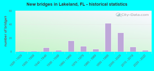
- New bridges - historical statistics
- 11920-1929
- 11930-1939
- 61940-1949
- 21950-1959
- 161960-1969
- 81970-1979
- 41980-1989
- 421990-1999
- 282000-2009
- 72010-2019
- 22020-2022
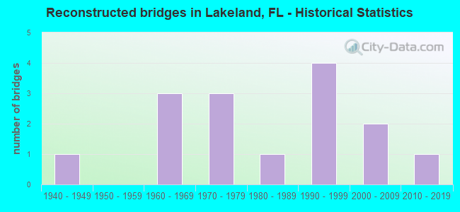
- Reconstructed bridges - Historical Statistics
- 11940-1949
- 01950-1959
- 31960-1969
- 31970-1979
- 11980-1989
- 41990-1999
- 22000-2009
- 12010-2019
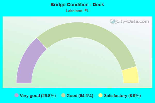
- Bridge Condition - Deck
- 26.8%Very good
- 64.3%Good
- 8.9%Satisfactory
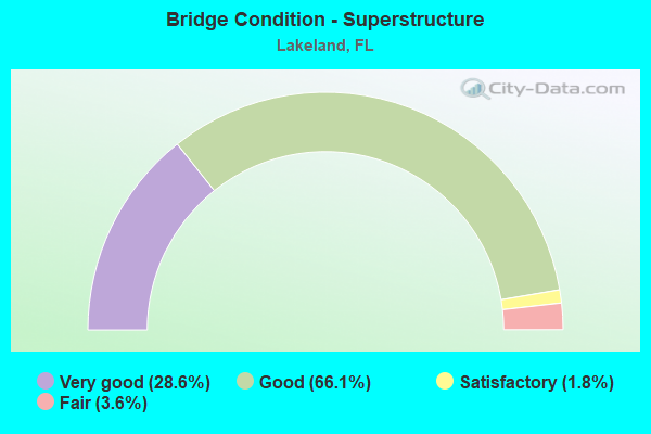
- Bridge Condition - Superstructure
- 28.6%Very good
- 66.1%Good
- 1.8%Satisfactory
- 3.6%Fair
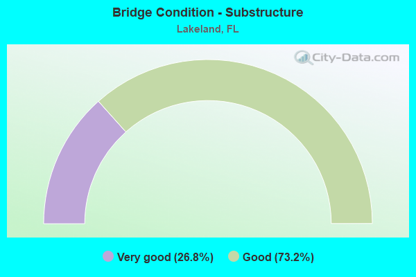
- Bridge Condition - Substructure
- 26.8%Very good
- 73.2%Good
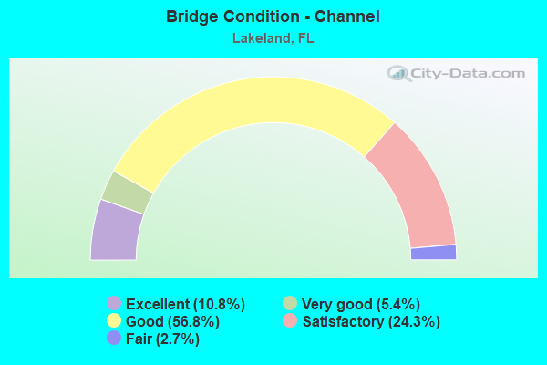
- Bridge Condition - Channel
- 10.8%Excellent
- 5.4%Very good
- 56.8%Good
- 24.3%Satisfactory
- 2.7%Fair
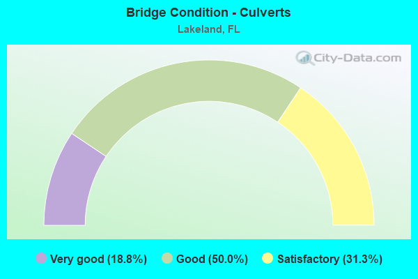
- Bridge Condition - Culverts
- 18.8%Very good
- 50.0%Good
- 31.3%Satisfactory
Find on map >> Show street view
Structure Number: 160322, Location: 0.9MI E OF US-98 (Lat: 28.093453, Lng: -81.958336), Route carried "on" structure: County highway , Year Built: 2004, Status: Open, Structure Length: 9.75m (31.99ft), Average Daily Traffic: 6,732 (year 2020), Truck Traffic: 2%, Average Future Daily Traffic: 11,680 (year 2042), Design Load: HS 20, Features Intersected: I-4 (SR-400), Facility Carried by Structure: CARPENTERS WAY
Minimum Vertical Clearance: 30+ m (98+ ft), Kilometerpoint: 0.164, Lanes on structure: 2, Lanes under structure: 6, Owner: State Highway Agency, Approaching Roadway Width: 10.5m (34.4ft), Material/Design: Prestressed concrete, Design/Construction: Stringer/Multi-beam, Number Of Spans In Main Unit: 2, Length of Maximum Span: 48.8m (160.1ft), Curb or Sidewalk Widths: Left: 2.0m (6.6ft), Right: 2.0m (6.6ft), Curb-To-Curb Width: 10.5m (34.4ft), Out-to-Out Width: 15.3m (50.2ft)
Condition: Deck: Good, Superstructure: Fair, Substructure: Good, Inventory Rating: 56.2 metric tons, Method Used To Determine Inventory Rating: Load Factor (LF), Structural Evaluation: Somewhat better than minimum adequacy, Deck Geometry: Meets minimum limits, Underclear: Better than present minimum criteria, Approach Roadway Alignment: Equal to present desirable criteria, Designated Inspection Frequency: Every 24 months, Inspection Date: July 2020, Deck Structure Type: Concrete Cast-file-Place
Find on map >> Show street view
Structure Number: 160323, Location: 2.4 MI EAST OF US-98 (Lat: 28.110083, Lng: -81.942361), Route carried "on" structure: County highway , Year Built: 2004, Status: Open, Structure Length: 10.82m (35.50ft), Average Daily Traffic: 9,200 (year 2020), Truck Traffic: 14%, Average Future Daily Traffic: 15,962 (year 2042), Design Load: HS 20, Features Intersected: I-4 (SR-400), Facility Carried by Structure: OLD COMBEE RD
Minimum Vertical Clearance: 30+ m (98+ ft), Kilometerpoint: 0.385, Lanes on structure: 2, Lanes under structure: 6, Owner: State Highway Agency, Approaching Roadway Width: 10.5m (34.4ft), Skew: 2 degrees, Material/Design: Steel continuous, Design/Construction: Stringer/Multi-beam, Number Of Spans In Main Unit: 2, Length of Maximum Span: 54.1m (177.5ft), Curb or Sidewalk Widths: Left: 2.0m (6.6ft), Right: 2.0m (6.6ft), Curb-To-Curb Width: 10.5m (34.4ft), Out-to-Out Width: 15.3m (50.2ft)
Condition: Deck: Very good, Superstructure: Good, Substructure: Good, Operating Rating: 55.5 metric tons, Method Used To Determine Operating Rating: Load Factor (LF), Inventory Rating: 33.3 metric tons, Method Used To Determine Inventory Rating: Load Factor (LF), Structural Evaluation: Better than present minimum criteria, Deck Geometry: Meets minimum limits, Underclear: Better than present minimum criteria, Approach Roadway Alignment: Equal to present desirable criteria, Designated Inspection Frequency: Every 24 months, Inspection Date: July 2020, Deck Structure Type: Concrete Cast-file-Place
Find on map >> Show street view
Structure Number: 160324, Location: 0.4 MI EAST OF SR-570 (Lat: 28.155667, Lng: -81.841806), Route carried "on" structure: County highway 400, Year Built: 2004, Status: Open, Structure Length: 10.18m (33.40ft), Average Daily Traffic: 3,400 (year 2020), Truck Traffic: 8%, Average Future Daily Traffic: 5,899 (year 2042), Design Load: HS 20, Features Intersected: I-4 (SR-400), Facility Carried by Structure: MT OLIVE CHURCH RD
Minimum Vertical Clearance: 30+ m (98+ ft), Kilometerpoint: 1.912, Lanes on structure: 2, Lanes under structure: 6, Owner: State Highway Agency, Approaching Roadway Width: 13.4m (44.0ft), Skew: 1 degrees, Material/Design: Prestressed concrete, Design/Construction: Stringer/Multi-beam, Number Of Spans In Main Unit: 2, Length of Maximum Span: 50.9m (167.0ft), Curb-To-Curb Width: 13.4m (44.0ft), Out-to-Out Width: 14.4m (47.2ft)
Condition: Deck: Very good, Superstructure: Good, Substructure: Very good, Operating Rating: 80.1 metric tons, Method Used To Determine Operating Rating: Load Factor (LF), Inventory Rating: 49.1 metric tons, Method Used To Determine Inventory Rating: Load Factor (LF), Structural Evaluation: Better than present minimum criteria, Deck Geometry: Better than present minimum criteria, Underclear: Superior to present desirable criteria, Approach Roadway Alignment: Equal to present desirable criteria, Designated Inspection Frequency: Every 24 months, Inspection Date: August 2020, Deck Structure Type: Concrete Cast-file-Place
Find on map >> Show street view
Structure Number: 160325, Location: 0.1MI EAST OF SUTTON RD. (Lat: 28.054944, Lng: -82.011000), Route carried "on" structure: City street , Year Built: 2005, Status: Open, Structure Length: 15.39m (50.49ft), Average Daily Traffic: 7,941 (year 2020), Truck Traffic: 5%, Average Future Daily Traffic: 13,778 (year 2042), Design Load: HS 20, Features Intersected: I-4 (SR-400), Facility Carried by Structure: SWINDELL ROAD
Minimum Vertical Clearance: 30+ m (98+ ft), Kilometerpoint: 0.695, Lanes on structure: 2, Lanes under structure: 7, Owner: State Highway Agency, Approaching Roadway Width: 13.4m (44.0ft), Skew: 5 degrees, Material/Design: Steel continuous, Design/Construction: Stringer/Multi-beam, Number Of Spans In Main Unit: 2, Length of Maximum Span: 77.0m (252.6ft), Curb or Sidewalk Widths: Left: 2.6m (8.5ft), Right: 2.6m (8.5ft), Curb-To-Curb Width: 13.4m (44.0ft), Out-to-Out Width: 19.8m (65.0ft)
Condition: Deck: Very good, Superstructure: Very good, Substructure: Very good, Operating Rating: 54.8 metric tons, Method Used To Determine Operating Rating: Load Factor (LF), Inventory Rating: 35.9 metric tons, Method Used To Determine Inventory Rating: Load Factor (LF), Structural Evaluation: Equal to present desirable criteria, Deck Geometry: Equal to present minimum criteria, Underclear: Equal to present desirable criteria, Approach Roadway Alignment: Equal to present desirable criteria, Designated Inspection Frequency: Every 24 months, Inspection Date: July 2020, Deck Structure Type: Concrete Cast-file-Place
Find on map >> Show street view
Structure Number: 160326, Location: 2.3 MI WEST OF US-98 (Lat: 28.062222, Lng: -82.000833), Route carried "on" structure: City street , Year Built: 2005, Status: Open, Structure Length: 15.42m (50.59ft), Average Daily Traffic: 5,500 (year 2020), Truck Traffic: 6%, Average Future Daily Traffic: 9,542 (year 2042), Design Load: HS 20, Features Intersected: I-4 (SR-400), Facility Carried by Structure: WEST 10TH ST.
Minimum Vertical Clearance: 30+ m (98+ ft), Kilometerpoint: 0.455, Lanes on structure: 2, Lanes under structure: 6, Owner: State Highway Agency, Approaching Roadway Width: 13.5m (44.3ft), Skew: 5 degrees, Material/Design: Steel continuous, Design/Construction: Stringer/Multi-beam, Number Of Spans In Main Unit: 2, Length of Maximum Span: 77.0m (252.6ft), Curb or Sidewalk Widths: Left: 2.5m (8.2ft), Right: 2.5m (8.2ft), Curb-To-Curb Width: 13.5m (44.3ft), Out-to-Out Width: 19.8m (65.0ft)
Condition: Deck: Good, Superstructure: Very good, Substructure: Good, Operating Rating: 54.8 metric tons, Method Used To Determine Operating Rating: Load Factor (LF), Inventory Rating: 35.9 metric tons, Method Used To Determine Inventory Rating: Load Factor (LF), Structural Evaluation: Better than present minimum criteria, Deck Geometry: Superior to present desirable criteria, Underclear: Superior to present desirable criteria, Approach Roadway Alignment: Equal to present desirable criteria, Designated Inspection Frequency: Every 24 months, Inspection Date: July 2020, Deck Structure Type: Concrete Cast-file-Place
Find on map >> Show street view
Structure Number: 160327, Location: 0.5 MI W OF KATHLEEN RD (Lat: 28.069678, Lng: -81.990881), Route carried "on" structure: City street , Year Built: 2005, Status: Open, Structure Length: 15.34m (50.33ft), Average Daily Traffic: 4,091 (year 2020), Truck Traffic: 10%, Average Future Daily Traffic: 7,098 (year 2042), Design Load: HL 93, Features Intersected: I-4 (SR-400), Facility Carried by Structure: W BELLA VISTA ST
Minimum Vertical Clearance: 30.45m (99.90ft), Kilometerpoint: 3.903, Lanes on structure: 2, Lanes under structure: 8, Owner: State Highway Agency, Approaching Roadway Width: 13.4m (44.0ft), Skew: 4 degrees, Material/Design: Steel continuous, Design/Construction: Stringer/Multi-beam, Number Of Spans In Main Unit: 2, Length of Maximum Span: 76.7m (251.6ft), Curb or Sidewalk Widths: Left: 1.6m (5.2ft), Right: 1.6m (5.2ft), Curb-To-Curb Width: 13.4m (44.0ft), Out-to-Out Width: 18.0m (59.1ft)
Condition: Deck: Satisfactory, Superstructure: Very good, Substructure: Very good, Operating Rating: 55.9 metric tons, Method Used To Determine Operating Rating: Load and Resistance Factor (LRFR), Inventory Rating: 41.8 metric tons, Method Used To Determine Inventory Rating: Load and Resistance Factor (LRFR), Structural Evaluation: Equal to present desirable criteria, Deck Geometry: Better than present minimum criteria, Underclear: Better than present minimum criteria, Approach Roadway Alignment: Equal to present desirable criteria, Designated Inspection Frequency: Every 24 months, Inspection Date: July 2020, Deck Structure Type: Concrete Cast-file-Place
Find on map >> Show street view
Structure Number: 160328, Location: 0.8 MI SOUTH OF CR-582 (Lat: 28.072736, Lng: -81.986858), Route carried "on" structure: State highway 539, Year Built: 2005, Status: Open, Structure Length: 9.92m (32.55ft), Average Daily Traffic: 32,500 (year 2020), Truck Traffic: 7%, Average Future Daily Traffic: 56,388 (year 2042), Design Load: HS 20+Mod, Features Intersected: I-4 (SR-400)
Minimum Vertical Clearance: 30+ m (98+ ft), Kilometerpoint: 3.880, Lanes on structure: 8, Lanes under structure: 6, Owner: State Highway Agency, Approaching Roadway Width: 32.9m (107.9ft), Skew: 21 degrees, Material/Design: Prestressed concrete, Design/Construction: Stringer/Multi-beam, Number Of Spans In Main Unit: 2, Length of Maximum Span: 49.7m (163.1ft), Curb or Sidewalk Widths: Left: 1.6m (5.2ft), Right: 1.6m (5.2ft), Curb-To-Curb Width: 32.9m (107.9ft), Out-to-Out Width: 37.7m (123.7ft)
Condition: Deck: Good, Superstructure: Good, Substructure: Good, Operating Rating: 57.2 metric tons, Method Used To Determine Operating Rating: Load Factor (LF), Inventory Rating: 21.5 metric tons, Method Used To Determine Inventory Rating: Load Factor (LF), Structural Evaluation: Somewhat better than minimum adequacy, Deck Geometry: Somewhat better than minimum adequacy, Underclear: Superior to present desirable criteria, Approach Roadway Alignment: Equal to present desirable criteria, Designated Inspection Frequency: Every 24 months, Inspection Date: July 2020, Deck Structure Type: Concrete Cast-file-Place
Find on map >> Show street view
Structure Number: 160329, Location: 0.7MI W OF US-98 (Lat: 28.080639, Lng: -81.976472), Route carried "on" structure: County highway 582, Year Built: 2005, Status: Open, Structure Length: 15.49m (50.82ft), Average Daily Traffic: 14,700 (year 2020), Truck Traffic: 4%, Average Future Daily Traffic: 25,504 (year 2042), Design Load: HL 93, Features Intersected: I-4 (SR-400)
Minimum Vertical Clearance: 30+ m (98+ ft), Kilometerpoint: 7.812, Lanes on structure: 4, Lanes under structure: 8, Owner: State Highway Agency, Approaching Roadway Width: 21.1m (69.2ft), Skew: 24 degrees, Material/Design: Steel continuous, Design/Construction: Stringer/Multi-beam, Number Of Spans In Main Unit: 2, Length of Maximum Span: 77.5m (254.3ft), Curb or Sidewalk Widths: Left: 2.0m (6.6ft), Right: 2.0m (6.6ft), Curb-To-Curb Width: 21.1m (69.2ft), Out-to-Out Width: 25.7m (84.3ft)
Condition: Deck: Very good, Superstructure: Very good, Substructure: Good, Operating Rating: 43.2 metric tons, Method Used To Determine Operating Rating: Load and Resistance Factor (LRFR), Inventory Rating: 33.3 metric tons, Method Used To Determine Inventory Rating: Load and Resistance Factor (LRFR), Structural Evaluation: Better than present minimum criteria, Deck Geometry: Superior to present desirable criteria, Underclear: High priority of corrective action, Approach Roadway Alignment: Equal to present desirable criteria, Designated Inspection Frequency: Every 24 months, Inspection Date: July 2020, Deck Structure Type: Concrete Cast-file-Place
Find on map >> Show street view
Structure Number: 160349, Location: 1.3MI E OF COMBEE RD (Lat: 28.047750, Lng: -81.886917), Route carried "on" structure: US 92, Year Built: 2016, Year Reconstructed: 2017, Status: Open, Structure Length: 1.62m (5.31ft), Average Daily Traffic: 32,500 (year 2019), Truck Traffic: 7%, Average Future Daily Traffic: 56,388 (year 2041), Design Load: HL 93, Features Intersected: Lk Parker Drainage Canal
Minimum Vertical Clearance: 30+ m (98+ ft), Kilometerpoint: 7.290, Lanes on structure: 4, Base Highway Network: Yes, Owner: State Highway Agency, Approaching Roadway Width: 9.3m (30.5ft), Skew: 20 degrees, Material/Design: Concrete, Design/Construction: Culvert, Number Of Spans In Main Unit: 4, Length of Maximum Span: 3.7m (12.1ft)
Condition: Channel: Good, Culverts: Very good, Operating Rating: 48.6 metric tons, Method Used To Determine Operating Rating: Load and Resistance Factor (LRFR), Inventory Rating: 37.6 metric tons, Method Used To Determine Inventory Rating: Load and Resistance Factor (LRFR), Structural Evaluation: Equal to present desirable criteria, Waterway Adequacy: Equal to present desirable criteria, Approach Roadway Alignment: Equal to present desirable criteria, Designated Inspection Frequency: Every 24 months, Inspection Date: January 2021
Find on map >> Show street view
Structure Number: 16035, Location: 1.9 MI EAST OF (SR-659) (Lat: 28.047781, Lng: -81.876639), Route carried "on" structure: US 92, Year Built: 2017, Status: Open, Structure Length: 5.12m (16.80ft), Average Daily Traffic: 16,250 (year 2019), Truck Traffic: 7%, Average Future Daily Traffic: 28,194 (year 2041), Design Load: HL 93, Features Intersected: SADDLE CREEK
Minimum Vertical Clearance: 30+ m (98+ ft), Kilometerpoint: 8.287, Lanes on structure: 2, Base Highway Network: Yes, Owner: State Highway Agency, Approaching Roadway Width: 12.2m (40.0ft), Material/Design: Concrete continuous, Design/Construction: Slab, Number Of Spans In Main Unit: 5, Length of Maximum Span: 11.0m (36.1ft), Curb-To-Curb Width: 12.2m (40.0ft), Out-to-Out Width: 13.1m (43.0ft)
Condition: Deck: Good, Superstructure: Good, Substructure: Very good, Channel: Good, Operating Rating: 66.0 metric tons, Method Used To Determine Operating Rating: Load and Resistance Factor (LRFR), Inventory Rating: 51.0 metric tons, Method Used To Determine Inventory Rating: Load and Resistance Factor (LRFR), Structural Evaluation: Better than present minimum criteria, Deck Geometry: Better than present minimum criteria, Waterway Adequacy: Equal to present desirable criteria, Approach Roadway Alignment: Equal to present desirable criteria, Designated Inspection Frequency: Every 24 months, Inspection Date: January 2021, Deck Structure Type: Concrete Cast-file-Place
Find on map >> Show street view
Structure Number: 160351, Location: 0.4 MI E OF SADDLE CRK RD (Lat: 28.047944, Lng: -81.876444), Route carried "on" structure: US 92, Year Built: 2017, Status: Open, Structure Length: 5.12m (16.80ft), Average Daily Traffic: 16,250 (year 2019), Truck Traffic: 7%, Average Future Daily Traffic: 28,194 (year 2041), Design Load: HL 93, Features Intersected: SADDLE CREEK
Minimum Vertical Clearance: 30.45m (99.90ft), Kilometerpoint: 8.287, Lanes on structure: 2, Base Highway Network: Yes, Owner: State Highway Agency, Approaching Roadway Width: 12.2m (40.0ft), Material/Design: Concrete continuous, Design/Construction: Slab, Number Of Spans In Main Unit: 5, Length of Maximum Span: 11.0m (36.1ft), Curb or Sidewalk Widths: Left: 1.6m (5.2ft), Right: 0.0m, Curb-To-Curb Width: 12.2m (40.0ft), Out-to-Out Width: 14.9m (48.9ft)
Condition: Deck: Good, Superstructure: Good, Substructure: Very good, Channel: Good, Operating Rating: 66.6 metric tons, Method Used To Determine Operating Rating: Load and Resistance Factor (LRFR), Inventory Rating: 51.3 metric tons, Method Used To Determine Inventory Rating: Load and Resistance Factor (LRFR), Structural Evaluation: Better than present minimum criteria, Deck Geometry: Better than present minimum criteria, Waterway Adequacy: Equal to present desirable criteria, Approach Roadway Alignment: Equal to present desirable criteria, Designated Inspection Frequency: Every 24 months, Inspection Date: January 2021, Deck Structure Type: Concrete Cast-file-Place
Find on map >> Show street view
Structure Number: 160526, Location: 0.3 MI EAST OF US-92 (Lat: 28.046022, Lng: -81.965664), Route carried "on" structure: State highway 548, Year Built: 2009, Status: Open, Structure Length: 4.71m (15.45ft), Average Daily Traffic: 15,100 (year 2020), Truck Traffic: 7%, Average Future Daily Traffic: 26,198 (year 2042), Design Load: HL 93, Features Intersected: CSX RR
Minimum Vertical Clearance: 30.45m (99.90ft), Kilometerpoint: 2.287, Lanes on structure: 4, Base Highway Network: Yes, Owner: State Highway Agency, Approaching Roadway Width: 19.0m (62.3ft), Skew: 25 degrees, Material/Design: Prestressed concrete, Design/Construction: Stringer/Multi-beam, Number Of Spans In Main Unit: 1, Length of Maximum Span: 47.1m (154.5ft), Curb or Sidewalk Widths: Left: 1.5m (4.9ft), Right: 1.5m (4.9ft), Curb-To-Curb Width: 19.0m (62.3ft), Out-to-Out Width: 29.3m (96.1ft)
Condition: Deck: Very good, Superstructure: Very good, Substructure: Very good, Operating Rating: 63.0 metric tons, Method Used To Determine Operating Rating: Load and Resistance Factor (LRFR), Inventory Rating: 57.5 metric tons, Method Used To Determine Inventory Rating: Load and Resistance Factor (LRFR), Structural Evaluation: Equal to present desirable criteria, Deck Geometry: Equal to present minimum criteria, Underclear: Somewhat better than minimum adequacy, Approach Roadway Alignment: Equal to present desirable criteria, Designated Inspection Frequency: Every 24 months, Inspection Date: August 2021, Deck Structure Type: Concrete Cast-file-Place
Find on map >> Show street view
Structure Number: 164117, Location: 0.8 Mi. South of CR 582 (Lat: 28.068094, Lng: -82.031372), Route carried "on" structure: County highway , Year Built: 1946, Year Reconstructed: 1960, Status: Open, Structure Length: 2.10m (6.89ft), Average Daily Traffic: 2,386 (year 2021), Truck Traffic: 3%, Average Future Daily Traffic: 4,140 (year 2042), Design Load: HS 20, Features Intersected: ITCHEPACKESASSA CREEK, Facility Carried by Structure: WALKER ROAD
Minimum Vertical Clearance: 30+ m (98+ ft), Kilometerpoint: 0.000, Lanes on structure: 2, Owner: County Highway Agency, Approaching Roadway Width: 6.6m (21.7ft), Material/Design: Prestressed concrete, Design/Construction: Tee Beam, Number Of Spans In Main Unit: 3, Length of Maximum Span: 7.5m (24.6ft), Curb-To-Curb Width: 6.6m (21.7ft), Out-to-Out Width: 7.3m (24.0ft)
Condition: Deck: Good, Superstructure: Good, Substructure: Good, Channel: Satisfactory, Operating Rating: 49.0 metric tons, Method Used To Determine Operating Rating: Load Factor (LF), Inventory Rating: 29.4 metric tons, Method Used To Determine Inventory Rating: Load Factor (LF), Structural Evaluation: Better than present minimum criteria, Deck Geometry: High priority of replacement, Waterway Adequacy: Better than present minimum criteria, Approach Roadway Alignment: Equal to present desirable criteria, Designated Inspection Frequency: Every 24 months, Inspection Date: September 2021, Deck Structure Type: Concrete Cast-file-Place, Wearing Surface/Protective System: Wearing Surface: Bituminous
Find on map >> Show street view
Structure Number: 16417, Location: 0.2 MI WEST OF US-98 (Lat: 28.135425, Lng: -81.976633), Route carried "on" structure: County highway , Year Built: 1987, Status: Open, Structure Length: 1.31m (4.30ft), Average Daily Traffic: 9,500 (year 2020), Truck Traffic: 13%, Average Future Daily Traffic: 16,483 (year 2042), Features Intersected: FOX BRANCH, Facility Carried by Structure: DUFF ROAD
Minimum Vertical Clearance: 30+ m (98+ ft), Kilometerpoint: 4.580, Lanes on structure: 2, Owner: County Highway Agency, Approaching Roadway Width: 6.2m (20.3ft), Material/Design: Prestressed concrete, Design/Construction: Slab, Number Of Spans In Main Unit: 1, Length of Maximum Span: 13.1m (43.0ft), Curb-To-Curb Width: 12.5m (41.0ft), Out-to-Out Width: 13.4m (44.0ft)
Condition: Deck: Good, Superstructure: Good, Substructure: Very good, Channel: Good, Operating Rating: 39.5 metric tons, Method Used To Determine Operating Rating: Load Factor (LF), Inventory Rating: 19.4 metric tons, Method Used To Determine Inventory Rating: Load Factor (LF), Structural Evaluation: Meets minimum limits, Deck Geometry: Somewhat better than minimum adequacy, Waterway Adequacy: Equal to present desirable criteria, Approach Roadway Alignment: Equal to present desirable criteria, Designated Inspection Frequency: Every 24 months, Inspection Date: December 2021, Deck Structure Type: Concrete Precast Panels, Wearing Surface/Protective System: Wearing Surface: Integral Concrete
Find on map >> Show street view
Structure Number: 164422, Location: 1.4MI E OF COUNTY LINE RD (Lat: 27.981978, Lng: -82.032789), Route carried "on" structure: County highway , Year Built: 1960, Status: Open, Structure Length: 0.76m (2.49ft), Average Daily Traffic: 1,150 (year 2020), Truck Traffic: 10%, Average Future Daily Traffic: 1,995 (year 2042), Design Load: HS 20, Features Intersected: ENGLISH CREEK, Facility Carried by Structure: MEDULLA ROAD
Minimum Vertical Clearance: 30+ m (98+ ft), Kilometerpoint: 2.245, Lanes on structure: 2, Owner: County Highway Agency, Approaching Roadway Width: 7.8m (25.6ft), Material/Design: Prestressed concrete, Design/Construction: Channel Beam, Number Of Spans In Main Unit: 1, Length of Maximum Span: 7.6m (24.9ft), Curb-To-Curb Width: 7.8m (25.6ft), Out-to-Out Width: 8.6m (28.2ft)
Condition: Deck: Good, Superstructure: Good, Substructure: Good, Channel: Satisfactory, Operating Rating: 47.0 metric tons, Method Used To Determine Operating Rating: Load Factor (LF), Inventory Rating: 28.1 metric tons, Method Used To Determine Inventory Rating: Load Factor (LF), Structural Evaluation: Better than present minimum criteria, Deck Geometry: Meets minimum limits, Waterway Adequacy: Better than present minimum criteria, Approach Roadway Alignment: Equal to present desirable criteria, Designated Inspection Frequency: Every 24 months, Inspection Date: September 2021, Deck Structure Type: Concrete Cast-file-Place, Wearing Surface/Protective System: Wearing Surface: Bituminous
Find on map >> Show street view
Structure Number: 164448, Location: 0.5 MI NORTH OF EWELL RD (Lat: 27.959528, Lng: -82.055583), Route carried "on" structure: County highway , Year Built: 1990, Year Reconstructed: 2009, Status: Open, Structure Length: 12.21m (40.06ft), Average Daily Traffic: 15,100 (year 2021), Truck Traffic: 12%, Average Future Daily Traffic: 26,198 (year 2042), Design Load: HL 93, Features Intersected: ENGLISH CREEK, Facility Carried by Structure: COUNTY LINE RD.
Minimum Vertical Clearance: 30+ m (98+ ft), Kilometerpoint: 3.513, Lanes on structure: 4, Base Highway Network: Yes, Owner: County Highway Agency, Approaching Roadway Width: 21.9m (71.9ft), Skew: 23 degrees, Material/Design: Prestressed concrete, Design/Construction: Stringer/Multi-beam, Number Of Spans In Main Unit: 4, Length of Maximum Span: 30.5m (100.1ft), Curb-To-Curb Width: 27.1m (88.9ft), Out-to-Out Width: 27.7m (90.9ft)
Condition: Deck: Satisfactory, Superstructure: Very good, Substructure: Very good, Channel: Good, Operating Rating: 39.2 metric tons, Method Used To Determine Operating Rating: Load and Resistance Factor (LRFR), Inventory Rating: 34.7 metric tons, Method Used To Determine Inventory Rating: Load and Resistance Factor (LRFR), Structural Evaluation: Equal to present desirable criteria, Deck Geometry: Superior to present desirable criteria, Waterway Adequacy: Equal to present desirable criteria, Approach Roadway Alignment: Equal to present desirable criteria, Designated Inspection Frequency: Every 24 months, Inspection Date: September 2021, Deck Structure Type: Concrete Cast-file-Place
Find on map >> Show street view
Structure Number: 16445, Location: 0.1MI E OF COUNTY LINE RD (Lat: 27.982047, Lng: -82.053617), Route carried "on" structure: County highway , Year Built: 1989, Status: Open, Structure Length: 3.05m (10.01ft), Average Daily Traffic: 1,150 (year 2020), Truck Traffic: 10%, Average Future Daily Traffic: 1,995 (year 2042), Design Load: HS 20, Features Intersected: HAMILTON CREEK, Facility Carried by Structure: MEDULLA RD
Minimum Vertical Clearance: 30+ m (98+ ft), Kilometerpoint: 0.220, Lanes on structure: 2, Owner: County Highway Agency, Approaching Roadway Width: 12.5m (41.0ft), Material/Design: Concrete continuous, Design/Construction: Slab, Number Of Spans In Main Unit: 3, Length of Maximum Span: 12.1m (39.7ft), Curb-To-Curb Width: 12.5m (41.0ft), Out-to-Out Width: 13.3m (43.6ft)
Condition: Deck: Satisfactory, Superstructure: Satisfactory, Substructure: Good, Channel: Satisfactory, Operating Rating: 41.7 metric tons, Method Used To Determine Operating Rating: Load and Resistance Factor (LRFR), Inventory Rating: 32.2 metric tons, Method Used To Determine Inventory Rating: Load and Resistance Factor (LRFR), Structural Evaluation: Equal to present minimum criteria, Deck Geometry: Better than present minimum criteria, Waterway Adequacy: Equal to present desirable criteria, Approach Roadway Alignment: Equal to present desirable criteria, Designated Inspection Frequency: Every 24 months, Inspection Date: September 2021, Deck Structure Type: Concrete Cast-file-Place
Find on map >> Show street view
Structure Number: 164501, Location: 0.1 MI SOUTH OF CR-582 (Lat: 28.079094, Lng: -81.957350), Route carried "on" structure: City street , Year Built: 1993, Status: Open, Structure Length: 0.90m (2.95ft), Average Daily Traffic: 3,300 (year 2021), Truck Traffic: 5%, Average Future Daily Traffic: 5,726 (year 2042), Design Load: HS 20, Features Intersected: LUGUNA CANAL, Facility Carried by Structure: NORTH FLORIDA AVE.
Minimum Vertical Clearance: 30+ m (98+ ft), Kilometerpoint: 0.000, Lanes on structure: 2, Owner: City or Municipal Highway Agency, Approaching Roadway Width: 11.4m (37.4ft), Material/Design: Concrete, Design/Construction: Culvert, Number Of Spans In Main Unit: 1, Length of Maximum Span: 9.0m (29.5ft), Curb or Sidewalk Widths: Left: 0.0m, Right: 1.5m (4.9ft)
Condition: Channel: Good, Culverts: Good, Operating Rating: 56.8 metric tons, Method Used To Determine Operating Rating: Load Factor (LF), Inventory Rating: 33.9 metric tons, Method Used To Determine Inventory Rating: Load Factor (LF), Structural Evaluation: Better than present minimum criteria, Waterway Adequacy: Equal to present minimum criteria, Approach Roadway Alignment: Equal to present desirable criteria, Designated Inspection Frequency: Every 24 months, Underwater Inspection Frequency: Every 24 months, Inspection Date: December 2021, Underwater Inspection Date: November 2021
Find on map >> Show street view
Structure Number: 164503, Location: 200FT S OF CAROLYN DR (Lat: 27.997167, Lng: -81.955583), Route carried "on" structure: City street , Year Built: 1994, Status: Open, Structure Length: 0.65m (2.13ft), Average Daily Traffic: 350 (year 2021), Average Future Daily Traffic: 607 (year 2042), Features Intersected: TIMMY'S DITCH, Facility Carried by Structure: WESTOVER STREET
Minimum Vertical Clearance: 30+ m (98+ ft), Kilometerpoint: 0.000, Lanes on structure: 2, Owner: City or Municipal Highway Agency, Approaching Roadway Width: 7.6m (24.9ft), Material/Design: Aluminum, Iron, Design/Construction: Culvert, Number Of Spans In Main Unit: 1, Length of Maximum Span: 6.5m (21.3ft)
Condition: Channel: Good, Culverts: Very good, Operating Rating: 39.6 metric tons, Method Used To Determine Operating Rating: Load Factor (LF), Inventory Rating: 23.9 metric tons, Method Used To Determine Inventory Rating: Load Factor (LF), Structural Evaluation: Equal to present minimum criteria, Waterway Adequacy: Equal to present desirable criteria, Approach Roadway Alignment: Meets minimum limits, Designated Inspection Frequency: Every 24 months, Inspection Date: May 2021
Find on map >> Show street view
Structure Number: 164504, Location: 98FT N OF N FRONTAGE RD (Lat: 27.997128, Lng: -81.968506), Route carried "on" structure: City street , Year Built: 1985, Status: Open, Structure Length: 2.37m (7.78ft), Average Daily Traffic: 1,500 (year 2021), Truck Traffic: 2%, Average Future Daily Traffic: 2,603 (year 2042), Design Load: HS 20, Features Intersected: DRAINAGE CANAL, Facility Carried by Structure: OAKBRIDGE BLVD NB
Minimum Vertical Clearance: 30+ m (98+ ft), Kilometerpoint: 0.000, Lanes on structure: 1, Owner: City or Municipal Highway Agency, Approaching Roadway Width: 4.3m (14.1ft), Material/Design: Wood or Timber, Design/Construction: Stringer/Multi-beam, Number Of Spans In Main Unit: 4, Length of Maximum Span: 5.8m (19.0ft), Curb or Sidewalk Widths: Left: 0.5m (1.6ft), Right: 2.1m (6.9ft), Curb-To-Curb Width: 4.3m (14.1ft), Out-to-Out Width: 8.0m (26.2ft)
Condition: Deck: Good, Superstructure: Good, Substructure: Good, Channel: Satisfactory, Operating Rating: 43.0 metric tons, Method Used To Determine Operating Rating: Allowable Stress (AS), Inventory Rating: 32.3 metric tons, Method Used To Determine Inventory Rating: Allowable Stress (AS), Structural Evaluation: Better than present minimum criteria, Deck Geometry: High priority of replacement, Waterway Adequacy: Superior to present desirable criteria, Approach Roadway Alignment: Equal to present desirable criteria, Designated Inspection Frequency: Every 24 months, Underwater Inspection Frequency: Every 24 months, Inspection Date: May 2021, Underwater Inspection Date: April 2021, Deck Structure Type: Wood or Timber, Wearing Surface/Protective System: Wearing Surface: Bituminous
Find on map >> Show street view
Structure Number: 164505, Location: 98FT N OF N FRONTAGE RD (Lat: 27.997125, Lng: -81.968614), Route carried "on" structure: City street , Year Built: 1985, Status: Open, Structure Length: 2.36m (7.74ft), Average Daily Traffic: 1,500 (year 2021), Truck Traffic: 2%, Average Future Daily Traffic: 2,603 (year 2042), Design Load: HS 20, Features Intersected: DRAINAGE CANAL, Facility Carried by Structure: OAKBRIDGE BLVD SB
Minimum Vertical Clearance: 30+ m (98+ ft), Kilometerpoint: 0.000, Lanes on structure: 1, Owner: City or Municipal Highway Agency, Approaching Roadway Width: 6.0m (19.7ft), Material/Design: Wood or Timber, Design/Construction: Stringer/Multi-beam, Number Of Spans In Main Unit: 4, Length of Maximum Span: 5.8m (19.0ft), Curb or Sidewalk Widths: Left: 0.5m (1.6ft), Right: 0.5m (1.6ft), Curb-To-Curb Width: 5.9m (19.4ft), Out-to-Out Width: 8.0m (26.2ft)
Condition: Deck: Good, Superstructure: Good, Substructure: Good, Channel: Satisfactory, Operating Rating: 43.0 metric tons, Method Used To Determine Operating Rating: Allowable Stress (AS), Inventory Rating: 32.3 metric tons, Method Used To Determine Inventory Rating: Allowable Stress (AS), Structural Evaluation: Better than present minimum criteria, Deck Geometry: High priority of replacement, Waterway Adequacy: Superior to present desirable criteria, Approach Roadway Alignment: Equal to present desirable criteria, Designated Inspection Frequency: Every 24 months, Underwater Inspection Frequency: Every 24 months, Inspection Date: May 2021, Underwater Inspection Date: April 2021, Deck Structure Type: Wood or Timber, Wearing Surface/Protective System: Wearing Surface: Bituminous
Find on map >> Show street view
Structure Number: 164506, Location: 0.1MI WEST OF MAIN ST. (Lat: 28.046383, Lng: -81.949133), Route carried "on" structure: US 98, Year Built: 2003, Status: Open, Structure Length: 24.53m (80.48ft), Average Daily Traffic: 34,500 (year 2020), Truck Traffic: 8%, Average Future Daily Traffic: 59,858 (year 2042), Design Load: HS 20+Mod, Features Intersected: CSX RR & CITY STREETS
Minimum Vertical Clearance: 30.45m (99.90ft), Kilometerpoint: 0.180, Lanes on structure: 4, Lanes under structure: 4, Base Highway Network: Yes, Owner: State Highway Agency, Approaching Roadway Width: 19.3m (63.3ft), Skew: 29 degrees, Material/Design: Steel continuous, Design/Construction: Stringer/Multi-beam, Number Of Spans In Main Unit: 6, Length of Maximum Span: 54.9m (180.1ft), Curb or Sidewalk Widths: Left: 1.6m (5.2ft), Right: 0.0m, Curb-To-Curb Width: 19.3m (63.3ft), Out-to-Out Width: 28.4m (93.2ft)
Condition: Deck: Good, Superstructure: Very good, Substructure: Good, Operating Rating: 57.5 metric tons, Method Used To Determine Operating Rating: Load Factor (LF), Inventory Rating: 34.6 metric tons, Method Used To Determine Inventory Rating: Load Factor (LF), Structural Evaluation: Better than present minimum criteria, Deck Geometry: Equal to present minimum criteria, Underclear: High priority of corrective action, Approach Roadway Alignment: Equal to present desirable criteria, Designated Inspection Frequency: Every 24 months, Inspection Date: July 2020, Deck Structure Type: Concrete Cast-file-Place
Find on map >> Show street view
Structure Number: 164509, Location: 1.3 MI S OF I-4 EAST (Lat: 28.135697, Lng: -81.840481), Route carried "on" structure: State highway 570, Year Built: 2011, Status: Open, Structure Length: 4.30m (14.11ft), Average Daily Traffic: 4,550 (year 2020), Truck Traffic: 17%, Average Future Daily Traffic: 7,894 (year 2042), Design Load: HL 93, Features Intersected: PACE RD
Minimum Vertical Clearance: 5.08m (16.67ft), Kilometerpoint: 36.999, Lanes on structure: 2, Lanes under structure: 8, Base Highway Network: Yes, Toll: On toll road, Owner: State Toll Authority, Approaching Roadway Width: 13.1m (43.0ft), Skew: 1 degrees, Material/Design: Prestressed concrete, Design/Construction: Stringer/Multi-beam, Number Of Spans In Main Unit: 1, Length of Maximum Span: 43.0m (141.1ft), Curb-To-Curb Width: 13.1m (43.0ft), Out-to-Out Width: 13.1m (43.0ft)
Condition: Deck: Very good, Superstructure: Good, Substructure: Good, Operating Rating: 36.9 metric tons, Method Used To Determine Operating Rating: Load and Resistance Factor (LRFR), Inventory Rating: 33.2 metric tons, Method Used To Determine Inventory Rating: Load and Resistance Factor (LRFR), Structural Evaluation: Better than present minimum criteria, Deck Geometry: Superior to present desirable criteria, Underclear: Better than present minimum criteria, Approach Roadway Alignment: Equal to present desirable criteria, Designated Inspection Frequency: Every 24 months, Inspection Date: May 2020, Deck Structure Type: Concrete Cast-file-Place
Find on map >> Show street view
Structure Number: 164524, Location: 0.3MI. E/O COUNTY LINE RD (Lat: 27.970975, Lng: -82.050497), Route carried "on" structure: County highway , Year Built: 2001, Status: Open, Structure Length: 11.58m (37.99ft), Average Daily Traffic: 5,150 (year 2020), Truck Traffic: 5%, Average Future Daily Traffic: 8,936 (year 2042), Design Load: HL 93, Features Intersected: ENGLISH CREEK, Facility Carried by Structure: W PIPKIN RD. WB
Minimum Vertical Clearance: 30.45m (99.90ft), Kilometerpoint: 0.452, Lanes on structure: 2, Base Highway Network: Yes, Owner: County Highway Agency, Approaching Roadway Width: 10.9m (35.8ft), Skew: 2 degrees, Material/Design: Prestressed concrete, Design/Construction: Stringer/Multi-beam, Number Of Spans In Main Unit: 5, Length of Maximum Span: 23.3m (76.4ft), Curb or Sidewalk Widths: Left: 1.4m (4.6ft), Right: 0.0m, Curb-To-Curb Width: 10.9m (35.8ft), Out-to-Out Width: 16.1m (52.8ft)
Condition: Deck: Very good, Superstructure: Good, Substructure: Very good, Channel: Excellent, Operating Rating: 42.5 metric tons, Method Used To Determine Operating Rating: Load and Resistance Factor (LRFR), Inventory Rating: 38.8 metric tons, Method Used To Determine Inventory Rating: Load and Resistance Factor (LRFR), Structural Evaluation: Better than present minimum criteria, Deck Geometry: Somewhat better than minimum adequacy, Waterway Adequacy: Equal to present desirable criteria, Approach Roadway Alignment: Equal to present desirable criteria, Designated Inspection Frequency: Every 24 months, Inspection Date: Febuary 2022, Deck Structure Type: Concrete Cast-file-Place, Wearing Surface/Protective System: Wearing Surface: Integral Concrete
Find on map >> Show street view
Structure Number: 164527, Location: 0.3MI. E/O COUNTY LINE RD (Lat: 27.970844, Lng: -82.050528), Route carried "on" structure: County highway , Year Built: 2002, Status: Open, Structure Length: 11.58m (37.99ft), Average Daily Traffic: 5,150 (year 2020), Truck Traffic: 5%, Average Future Daily Traffic: 8,936 (year 2042), Design Load: HL 93, Features Intersected: ENGLISH CREEK, Facility Carried by Structure: W PIPKIN RD. EB
Minimum Vertical Clearance: 30.45m (99.90ft), Kilometerpoint: 0.452, Lanes on structure: 2, Base Highway Network: Yes, Owner: County Highway Agency, Approaching Roadway Width: 10.8m (35.4ft), Skew: 3 degrees, Material/Design: Prestressed concrete, Design/Construction: Stringer/Multi-beam, Number Of Spans In Main Unit: 5, Length of Maximum Span: 23.2m (76.1ft), Curb or Sidewalk Widths: Left: 0.0m, Right: 1.5m (4.9ft), Curb-To-Curb Width: 10.8m (35.4ft), Out-to-Out Width: 15.2m (49.9ft)
Condition: Deck: Good, Superstructure: Very good, Substructure: Very good, Channel: Excellent, Operating Rating: 50.3 metric tons, Method Used To Determine Operating Rating: Load and Resistance Factor (LRFR), Inventory Rating: 46.1 metric tons, Method Used To Determine Inventory Rating: Load and Resistance Factor (LRFR), Structural Evaluation: Equal to present desirable criteria, Deck Geometry: Somewhat better than minimum adequacy, Waterway Adequacy: Equal to present desirable criteria, Approach Roadway Alignment: Equal to present desirable criteria, Designated Inspection Frequency: Every 24 months, Inspection Date: Febuary 2022, Deck Structure Type: Concrete Cast-file-Place, Wearing Surface/Protective System: Wearing Surface: Integral Concrete
Find on map >> Show street view
Structure Number: 164534, Location: 1.0MI N OF LAKE MIRIAM DR (Lat: 27.990458, Lng: -81.924000), Route carried "on" structure: County highway 37B, Year Built: 2011, Status: Open, Structure Length: 0.70m (2.30ft), Average Daily Traffic: 25,500 (year 2019), Truck Traffic: 14%, Average Future Daily Traffic: 44,243 (year 2041), Design Load: HL 93, Features Intersected: DEERFIELD CREEK
Minimum Vertical Clearance: 30+ m (98+ ft), Kilometerpoint: 1.743, Lanes on structure: 5, Owner: County Highway Agency, Approaching Roadway Width: 14.6m (47.9ft), Skew: 20 degrees, Material/Design: Concrete, Design/Construction: Culvert, Number Of Spans In Main Unit: 3, Length of Maximum Span: 2.1m (6.9ft), Curb or Sidewalk Widths: Left: 2.0m (6.6ft), Right: 2.0m (6.6ft)
Condition: Channel: Good, Culverts: Very good, Operating Rating: 71.5 metric tons, Method Used To Determine Operating Rating: Load and Resistance Factor (LRFR), Inventory Rating: 55.2 metric tons, Method Used To Determine Inventory Rating: Load and Resistance Factor (LRFR), Structural Evaluation: Equal to present desirable criteria, Waterway Adequacy: Superior to present desirable criteria, Approach Roadway Alignment: Equal to present desirable criteria, Designated Inspection Frequency: Every 24 months, Inspection Date: July 2020
Find on map >> Show street view
Structure Number: 165001, Location: 0.3MI NORTH OF EWELL RD (Lat: 27.957611, Lng: -82.034944), Route carried "on" structure: City street , Year Built: 2020, Status: Open, Structure Length: 5.33m (17.49ft), Average Daily Traffic: 30 (year 2020), Average Future Daily Traffic: 38 (year 2040), Design Load: HL 93, Features Intersected: WETLAND CONSERVATION, Facility Carried by Structure: STREET 4B
Minimum Vertical Clearance: 30+ m (98+ ft), Kilometerpoint: 0.000, Lanes on structure: 2, Owner: City or Municipal Highway Agency, Approaching Roadway Width: 7.0m (23.0ft), Material/Design: Concrete continuous, Design/Construction: Slab, Number Of Spans In Main Unit: 5, Length of Maximum Span: 10.7m (35.1ft), Curb or Sidewalk Widths: Left: 2.0m (6.6ft), Right: 2.0m (6.6ft), Curb-To-Curb Width: 7.0m (23.0ft), Out-to-Out Width: 11.6m (38.1ft)
Condition: Deck: Good, Superstructure: Very good, Substructure: Very good, Channel: Very good, Operating Rating: 53.1 metric tons, Method Used To Determine Operating Rating: Load and Resistance Factor (LRFR), Inventory Rating: 40.9 metric tons, Method Used To Determine Inventory Rating: Load and Resistance Factor (LRFR), Structural Evaluation: Equal to present desirable criteria, Deck Geometry: Somewhat better than minimum adequacy, Waterway Adequacy: Equal to present desirable criteria, Approach Roadway Alignment: Equal to present desirable criteria, Designated Inspection Frequency: Every 24 months, Inspection Date: August 2020, Deck Structure Type: Concrete Cast-file-Place
Find on map >> Show street view
Structure Number: 165703, Location: 1000Ft. E of SR-33 (Lat: 28.089750, Lng: -81.950361), Route carried "on" structure: City street , Year Built: 2016, Status: Open, Structure Length: 0.97m (3.18ft), Average Daily Traffic: 20 (year 2021), Average Future Daily Traffic: 35 (year 2042), Design Load: HL 93, Features Intersected: Lake Crago Canal, Facility Carried by Structure: Lake Crago Drive
Minimum Vertical Clearance: 30+ m (98+ ft), Kilometerpoint: 0.000, Lanes on structure: 2, Owner: City or Municipal Highway Agency, Approaching Roadway Width: 8.1m (26.6ft), Material/Design: Aluminum, Iron, Design/Construction: Culvert, Number Of Spans In Main Unit: 1, Length of Maximum Span: 9.7m (31.8ft), Curb or Sidewalk Widths: Left: 0.2m (0.7ft), Right: 3.2m (10.5ft), Curb-To-Curb Width: 8.1m (26.6ft), Out-to-Out Width: 8.1m (26.6ft)
Condition: Channel: Excellent, Culverts: Good, Operating Rating: 33.7 metric tons, Method Used To Determine Operating Rating: Load and Resistance Factor (LRFR), Inventory Rating: 25.9 metric tons, Method Used To Determine Inventory Rating: Load and Resistance Factor (LRFR), Structural Evaluation: Equal to present minimum criteria, Deck Geometry: Equal to present minimum criteria, Waterway Adequacy: Superior to present desirable criteria, Approach Roadway Alignment: Equal to present desirable criteria, Designated Inspection Frequency: Every 24 months, Underwater Inspection Frequency: Every 24 months, Inspection Date: Febuary 2021, Underwater Inspection Date: January 2021, Wearing Surface/Protective System: Deck Protection: Other
Find on map >> Show street view
Structure Number: 160023, Location: 0.3 MI S/O US-92 (Lat: 28.048111, Lng: -81.940889), Route carried "under" structure: City street 98, Year Built: 1962, Structure Length: 0. m, Average Daily Traffic: 31,230 (year 2021), Truck Traffic: 5%, Features Intersected: N LAKE PARKER AVE, Facility Carried by Structure: CSX RR
Minimum Vertical Clearance: 4.57m (14.99ft), Kilometerpoint: 1.088, Lanes under structure: 4, Material/Design: Steel, Design/Construction: Stringer/Multi-beam, Length of Maximum Span: 14.0m (45.9ft)
Find on map >> Show street view
Structure Number: 160028, Location: 0.3 MI N OF MAIN ST (Lat: 28.048611, Lng: -81.939167), Route carried "under" structure: Business US 92, Year Built: 1943, Structure Length: 0. m, Average Daily Traffic: 4,500 (year 2020), Truck Traffic: 5%, Features Intersected: US-92 BUS (N GARY), Facility Carried by Structure: CSX RR
Minimum Vertical Clearance: 4.11m (13.48ft), Kilometerpoint: 2.041, Lanes under structure: 2, Material/Design: Concrete, Design/Construction: Slab, Length of Maximum Span: 7.6m (24.9ft)
Find on map >> Show street view
Structure Number: 160068, Location: 0.7 MI S OF I-4 (SR-400) (Lat: 28.054856, Lng: -81.970322), Route carried "under" structure: State highway 539, Year Built: 1953, Structure Length: 0. m, Average Daily Traffic: 33,500 (year 2020), Truck Traffic: 6%, Features Intersected: SR-539 (KATHLEEN RD), Facility Carried by Structure: US-92 (SR-600A)
Minimum Vertical Clearance: 6.74m (22.11ft), Kilometerpoint: 1.263, Lanes on structure: 4, Lanes under structure: 4, Material/Design: Steel continuous, Design/Construction: Stringer/Multi-beam, Length of Maximum Span: 38.4m (126.0ft)
Find on map >> Show street view
Structure Number: 160173, Location: 0.3MI W OF CR-35A (Lat: 28.070539, Lng: -81.989842), Route carried "under" structure: Interstate 4, Year Built: 1961, Structure Length: 0. m, Average Daily Traffic: 104,000 (year 2017), Truck Traffic: 14%, Features Intersected: I-4, Facility Carried by Structure: CSX RR
Minimum Vertical Clearance: 5.58m (18.31ft), Kilometerpoint: 7.865, Lanes under structure: 6, Material/Design: Steel, Design/Construction: Girder and Floorbeam System, Length of Maximum Span: 21.4m (70.2ft)
Find on map >> Show street view
Structure Number: 160173, Location: 0.3MI W OF CR-35A (Lat: 28.070539, Lng: -81.989842), Route carried "under" structure: Ramp Interstate 4, Year Built: 1961, Structure Length: 0. m, Average Daily Traffic: 5,500 (year 2019), Truck Traffic: 14%, Features Intersected: I-4, Facility Carried by Structure: CSX RR
Minimum Vertical Clearance: 5.85m (19.19ft), Kilometerpoint: 0.042, Lanes under structure: 1, Material/Design: Steel, Design/Construction: Girder and Floorbeam System, Length of Maximum Span: 21.4m (70.2ft)
Find on map >> Show street view
Structure Number: 160173, Location: 0.3MI W OF CR-35A (Lat: 28.070539, Lng: -81.989842), Route carried "under" structure: Ramp Interstate , Year Built: 1961, Structure Length: 0. m, Average Daily Traffic: 5,400 (year 2019), Truck Traffic: 14%, Features Intersected: I-4, Facility Carried by Structure: CSX RR
Minimum Vertical Clearance: 5.91m (19.39ft), Kilometerpoint: 0.373, Lanes under structure: 1, Material/Design: Steel, Design/Construction: Girder and Floorbeam System, Length of Maximum Span: 21.4m (70.2ft)
Find on map >> Show street view
Structure Number: 160177, Location: 1.4 MI E OF US-98 (Lat: 28.098106, Lng: -81.951411), Route carried "under" structure: County highway 582, Year Built: 1961, Structure Length: 0. m, Average Daily Traffic: 24,500 (year 2020), Truck Traffic: 4%, Features Intersected: CR-582 (SOCRUM LOOP RD), Facility Carried by Structure: I-4 WB (SR-400)
Minimum Vertical Clearance: 5.03m (16.50ft), Kilometerpoint: 12.007, Lanes on structure: 3, Lanes under structure: 4, Material/Design: Prestressed concrete, Design/Construction: Stringer/Multi-beam, Length of Maximum Span: 19.2m (63.0ft)
Find on map >> Show street view
Structure Number: 160178, Location: 1.4MI E OF US-98 (Lat: 28.097594, Lng: -81.951472), Route carried "under" structure: County highway 582, Year Built: 1961, Structure Length: 0. m, Average Daily Traffic: 24,500 (year 2020), Truck Traffic: 4%, Features Intersected: CR-582 (SOCRUM LOOP RD), Facility Carried by Structure: I-4 EB (SR-400)
Minimum Vertical Clearance: 5.79m (19.00ft), Kilometerpoint: 11.974, Lanes on structure: 3, Lanes under structure: 4, Material/Design: Prestressed concrete, Design/Construction: Stringer/Multi-beam, Length of Maximum Span: 18.3m (60.0ft)
Find on map >> Show street view
Structure Number: 160181, Location: 3.4 MI WEST OF SR-570 (Lat: 28.140372, Lng: -81.898475), Route carried "under" structure: State highway 33, Year Built: 1961, Structure Length: 0. m, Average Daily Traffic: 14,400 (year 2020), Truck Traffic: 21%, Features Intersected: SR-33 (LAKELAND HILLS BL, Facility Carried by Structure: I-4 WB (SR-400)
Minimum Vertical Clearance: 4.57m (14.99ft), Kilometerpoint: 13.589, Lanes on structure: 3, Lanes under structure: 2, Material/Design: Prestressed concrete, Design/Construction: Stringer/Multi-beam, Length of Maximum Span: 18.6m (61.0ft)
Find on map >> Show street view
Structure Number: 160182, Location: 3.4 MI W OF SR-570 (Lat: 28.139986, Lng: -81.898664), Route carried "under" structure: State highway 33, Year Built: 1961, Structure Length: 0. m, Average Daily Traffic: 11,300 (year 2020), Truck Traffic: 18%, Features Intersected: SR-33 (LAKELAND HILLS B, Facility Carried by Structure: I-4 EB (SR-400)
Minimum Vertical Clearance: 4.51m (14.80ft), Kilometerpoint: 13.551, Lanes on structure: 3, Lanes under structure: 2, Material/Design: Prestressed concrete, Design/Construction: Stringer/Multi-beam, Length of Maximum Span: 18.6m (61.0ft)
Find on map >> Show street view
Structure Number: 160189, Location: 0.2MI W OF SR-37 (Lat: 28.044167, Lng: -81.961111), Route carried "under" structure: State highway 563, Year Built: 1975, Structure Length: 0. m, Average Daily Traffic: 30,500 (year 2019), Truck Traffic: 4%, Features Intersected: SR-563 (SIKES BLVD), Facility Carried by Structure: CSX RR (2 TRACKS)
Minimum Vertical Clearance: 5.03m (16.50ft), Kilometerpoint: 0.426, Lanes under structure: 5, Material/Design: Steel, Design/Construction: Stringer/Multi-beam, Length of Maximum Span: 19.2m (63.0ft)
Find on map >> Show street view
Structure Number: 16019, Location: 0.2MI W OF SR-37 (Lat: 28.044064, Lng: -81.960964), Route carried "under" structure: State highway 563, Year Built: 1975, Structure Length: 0. m, Average Daily Traffic: 26,500 (year 2020), Truck Traffic: 5%, Features Intersected: SIKES BLVD (SR-563), Facility Carried by Structure: MAIN ST (CR-542)
Minimum Vertical Clearance: 5.12m (16.80ft), Kilometerpoint: 0.404, Lanes on structure: 2, Lanes under structure: 5, Material/Design: Prestressed concrete, Design/Construction: Stringer/Multi-beam, Length of Maximum Span: 28.3m (92.8ft)
Find on map >> Show street view
Structure Number: 160191, Location: 0.2 MI WEST OF SR-37 (Lat: 28.042897, Lng: -81.960500), Route carried "under" structure: State highway 563, Year Built: 1975, Structure Length: 0. m, Average Daily Traffic: 25,500 (year 2020), Truck Traffic: 15%, Features Intersected: SIKES BLVD (SR-563), Facility Carried by Structure: LEMON ST
Minimum Vertical Clearance: 5.06m (16.60ft), Kilometerpoint: 0.264, Lanes on structure: 2, Lanes under structure: 6, Material/Design: Prestressed concrete, Design/Construction: Stringer/Multi-beam, Length of Maximum Span: 34.0m (111.5ft)
Find on map >> Show street view
Structure Number: 160192, Location: 0.2MI W OF SR-37 (Lat: 28.041678, Lng: -81.960114), Route carried "under" structure: State highway 563, Year Built: 1974, Structure Length: 0. m, Average Daily Traffic: 25,500 (year 2020), Truck Traffic: 5%, Features Intersected: SR-563, Facility Carried by Structure: WEST ORANGE STREET
Minimum Vertical Clearance: 5.00m (16.40ft), Kilometerpoint: 0.126, Lanes on structure: 2, Lanes under structure: 4, Material/Design: Prestressed concrete, Design/Construction: Stringer/Multi-beam, Length of Maximum Span: 25.3m (83.0ft)
Find on map >> Show street view
Structure Number: 160249, Location: 0.4MI W OF HARDEN BLVD (Lat: 27.996278, Lng: -81.981861), Route carried "under" structure: City street , Year Built: 1998, Structure Length: 0. m, Average Daily Traffic: 50 (year 2002), Truck Traffic: 25%, Features Intersected: CSXRR,Beaker&WilkinsonRd, Facility Carried by Structure: S FRONTAGE RD 5.0
Minimum Vertical Clearance: 5.86m (19.23ft), Kilometerpoint: 0.000, Lanes on structure: 3, Lanes under structure: 2, Material/Design: Steel continuous, Design/Construction: Stringer/Multi-beam, Length of Maximum Span: 60.3m (197.8ft)
Find on map >> Show street view
Structure Number: 16025, Location: 0.4 MI W OF HARDEN BLVD (Lat: 27.996769, Lng: -81.982525), Route carried "under" structure: City street , Year Built: 1998, Structure Length: 0. m, Average Daily Traffic: 15,900 (year 2016), Truck Traffic: 12%, Features Intersected: CSXRR,Beaker&WilkinsonRd, Facility Carried by Structure: SR 570 POLK WB 5.1
Minimum Vertical Clearance: 7.98m (26.18ft), Kilometerpoint: 0.000, Lanes on structure: 3, Lanes under structure: 2, Material/Design: Steel continuous, Design/Construction: Stringer/Multi-beam, Length of Maximum Span: 60.0m (196.9ft)
Find on map >> Show street view
Structure Number: 160251, Location: 0.4 MI W OF HARDEN BLVD (Lat: 27.996472, Lng: -81.982222), Route carried "under" structure: City street , Year Built: 1998, Structure Length: 0. m, Average Daily Traffic: 15,900 (year 2016), Truck Traffic: 12%, Features Intersected: CSXRR,Beaker&WilkinsonRd, Facility Carried by Structure: SR 570 POLK EB 5.1
Minimum Vertical Clearance: 8.13m (26.67ft), Kilometerpoint: 0.000, Lanes on structure: 2, Lanes under structure: 2, Material/Design: Steel continuous, Design/Construction: Stringer/Multi-beam, Length of Maximum Span: 59.5m (195.2ft)
Find on map >> Show street view
Structure Number: 160252, Location: 0.4 MI W OF HARDEN BLVD (Lat: 27.996911, Lng: -81.982653), Route carried "under" structure: City street , Year Built: 1998, Structure Length: 0. m, Average Daily Traffic: 50 (year 2002), Truck Traffic: 25%, Features Intersected: CSXRR,Beaker&WilkinsonRd, Facility Carried by Structure: N FRONTAGE RD 5.1
Minimum Vertical Clearance: 6.04m (19.82ft), Kilometerpoint: 0.000, Lanes on structure: 2, Lanes under structure: 2, Material/Design: Steel continuous, Design/Construction: Stringer/Multi-beam, Length of Maximum Span: 60.1m (197.2ft)
Find on map >> Show street view
Structure Number: 160255, Location: 6.3 MI EAST OF I-4 WEST (Lat: 27.996483, Lng: -81.963911), Route carried "under" structure: City street , Year Built: 1998, Structure Length: 0. m, Average Daily Traffic: 17,150 (year 2020), Truck Traffic: 17%, Features Intersected: UNDERPASS ROAD, Facility Carried by Structure: SR 570 POLK WB 6.2
Minimum Vertical Clearance: 5.56m (18.24ft), Kilometerpoint: 10.066, Lanes on structure: 2, Lanes under structure: 3, Material/Design: Prestressed concrete, Design/Construction: Stringer/Multi-beam, Length of Maximum Span: 25.7m (84.3ft)
Find on map >> Show street view
Structure Number: 160256, Location: 6.3 MI EAST OF I-4 WEST (Lat: 27.996250, Lng: -81.963903), Route carried "under" structure: City street , Year Built: 1998, Structure Length: 0. m, Average Daily Traffic: 17,150 (year 2020), Truck Traffic: 17%, Features Intersected: UNDERPASS ROAD, Facility Carried by Structure: SR 570 POLK EB 6.2
Minimum Vertical Clearance: 5.57m (18.27ft), Kilometerpoint: 10.066, Lanes on structure: 4, Lanes under structure: 3, Material/Design: Prestressed concrete, Design/Construction: Stringer/Multi-beam, Length of Maximum Span: 25.7m (84.3ft)
Find on map >> Show street view
Structure Number: 160257, Location: 6.8 MI EAST OF I-4 WEST (Lat: 27.996222, Lng: -81.957006), Route carried "under" structure: State highway 37, Year Built: 1998, Structure Length: 0. m, Average Daily Traffic: 32,500 (year 2020), Truck Traffic: 3%, Features Intersected: SR 37 S FLORIDA AVE, Facility Carried by Structure: SR 570 POLK WB 6.6
Minimum Vertical Clearance: 5.73m (18.80ft), Kilometerpoint: 40.842, Lanes on structure: 3, Lanes under structure: 10, Material/Design: Steel, Design/Construction: Stringer/Multi-beam, Length of Maximum Span: 54.8m (179.8ft)
Find on map >> Show street view
Structure Number: 160258, Location: 6.8 MI EAST OF I-4 WEST (Lat: 27.995992, Lng: -81.957006), Route carried "under" structure: State highway 37, Year Built: 1998, Structure Length: 0. m, Average Daily Traffic: 38,000 (year 2020), Truck Traffic: 5%, Features Intersected: SR 37 S FLORIDA AVE, Facility Carried by Structure: SR 570 POLK EB 6.6
Minimum Vertical Clearance: 5.11m (16.77ft), Kilometerpoint: 40.818, Lanes on structure: 2, Lanes under structure: 10, Material/Design: Steel, Design/Construction: Stringer/Multi-beam, Length of Maximum Span: 54.8m (179.8ft)
Find on map >> Show street view
Structure Number: 160259, Location: 7.3 MI EAST OF I-4 WEST (Lat: 27.994700, Lng: -81.948747), Route carried "under" structure: City street , Year Built: 1998, Structure Length: 0. m, Average Daily Traffic: 18,350 (year 2020), Truck Traffic: 17%, Features Intersected: CLEVELAND HEIGHTS BLVD, Facility Carried by Structure: SR 570 POLK WB 7.2
Minimum Vertical Clearance: 5.18m (16.99ft), Kilometerpoint: 11.586, Lanes on structure: 3, Lanes under structure: 3, Material/Design: Prestressed concrete, Design/Construction: Stringer/Multi-beam, Length of Maximum Span: 38.2m (125.3ft)
Find on map >> Show street view
Structure Number: 16026, Location: 7.3 MI EAST OF I-4 WEST (Lat: 27.994483, Lng: -81.948744), Route carried "under" structure: City street , Year Built: 1998, Structure Length: 0. m, Average Daily Traffic: 18,350 (year 2020), Truck Traffic: 17%, Features Intersected: CLEVELAND HEIGHTS BLVD, Facility Carried by Structure: SR 570 POLK EB 7.2
Minimum Vertical Clearance: 5.25m (17.22ft), Kilometerpoint: 11.584, Lanes on structure: 2, Lanes under structure: 2, Material/Design: Prestressed concrete, Design/Construction: Stringer/Multi-beam, Length of Maximum Span: 38.2m (125.3ft)
Find on map >> Show street view
Structure Number: 160263, Location: 10.1 MI EAST OF I-4 WEST (Lat: 28.000692, Lng: -81.901964), Route carried "under" structure: US 98, Year Built: 1999, Structure Length: 0. m, Average Daily Traffic: 39,000 (year 2020), Truck Traffic: 10%, Features Intersected: US 98, Facility Carried by Structure: SR570 POLK WB 10.1
Minimum Vertical Clearance: 5.06m (16.60ft), Kilometerpoint: 13.111, Lanes on structure: 4, Lanes under structure: 9, Material/Design: Prestressed concrete, Design/Construction: Stringer/Multi-beam, Length of Maximum Span: 28.0m (91.9ft)
Find on map >> Show street view
Structure Number: 160264, Location: 10.1 MI EAST OF I-4 WEST (Lat: 28.000472, Lng: -81.901789), Route carried "under" structure: US 98, Year Built: 1999, Structure Length: 0. m, Average Daily Traffic: 39,000 (year 2020), Truck Traffic: 10%, Features Intersected: US 98, Facility Carried by Structure: SR570 EB POLK 10.1
Minimum Vertical Clearance: 4.94m (16.21ft), Kilometerpoint: 13.081, Lanes on structure: 3, Lanes under structure: 9, Material/Design: Prestressed concrete, Design/Construction: Stringer/Multi-beam, Length of Maximum Span: 28.1m (92.2ft)
Find on map >> Show street view
Structure Number: 160273, Location: 11.1 MI EAST OF I-4 (Lat: 28.005697, Lng: -81.889217), Route carried "under" structure: City street , Year Built: 1998, Structure Length: 0. m, Average Daily Traffic: 7,600 (year 2020), Truck Traffic: 22%, Features Intersected: REYNOLDS ROAD, Facility Carried by Structure: SR 570 WB 10.8
Minimum Vertical Clearance: 5.16m (16.93ft), Kilometerpoint: 0.966, Lanes on structure: 2, Lanes under structure: 2, Material/Design: Prestressed concrete, Design/Construction: Stringer/Multi-beam, Length of Maximum Span: 34.5m (113.2ft)
Find on map >> Show street view
Structure Number: 160274, Location: 11.1 MI EAST OF I-4 (Lat: 28.005492, Lng: -81.889100), Route carried "under" structure: City street , Year Built: 1998, Structure Length: 0. m, Average Daily Traffic: 7,600 (year 2020), Truck Traffic: 22%, Features Intersected: REYNOLDS ROAD, Facility Carried by Structure: SR 570 EB 10.8
Minimum Vertical Clearance: 5.13m (16.83ft), Kilometerpoint: 0.966, Lanes on structure: 2, Lanes under structure: 2, Material/Design: Prestressed concrete, Design/Construction: Stringer/Multi-beam, Length of Maximum Span: 34.5m (113.2ft)
Find on map >> Show street view
Structure Number: 160288, Location: 1.3 MI S OF I-4 EAST (Lat: 28.135703, Lng: -81.840142), Route carried "under" structure: County highway , Year Built: 1999, Structure Length: 0. m, Average Daily Traffic: 30,370 (year 2011), Truck Traffic: 2%, Features Intersected: PACE RD, Facility Carried by Structure: SR 570 POLK 22.9
Minimum Vertical Clearance: 4.92m (16.14ft), Kilometerpoint: 0.000, Lanes on structure: 3, Lanes under structure: 8, Material/Design: Prestressed concrete, Design/Construction: Stringer/Multi-beam, Length of Maximum Span: 41.5m (136.2ft)
Find on map >> Show street view
Structure Number: 160297, Location: 0.7MI N OF NEW TAMPA HWY. (Lat: 28.036806, Lng: -82.055942), Route carried "under" structure: Interstate 4, Year Built: 1999, Structure Length: 0. m, Average Daily Traffic: 118,000 (year 2020), Truck Traffic: 16%, Features Intersected: I-4 (SR-400), Facility Carried by Structure: COUNTY LINE ROAD
Minimum Vertical Clearance: 6.16m (20.21ft), Kilometerpoint: 0.002, Lanes on structure: 4, Lanes under structure: 8, Material/Design: Prestressed concrete, Design/Construction: Stringer/Multi-beam, Length of Maximum Span: 42.1m (138.1ft)