Bridge Statistics for Lakewood, Colorado (CO)
Condition, Traffic, Stress, Structural Evaluation, Project Costs
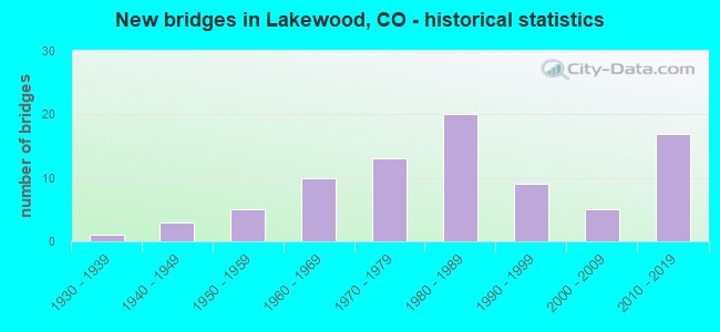
- New bridges - historical statistics
- 11930-1939
- 31940-1949
- 51950-1959
- 101960-1969
- 131970-1979
- 201980-1989
- 91990-1999
- 52000-2009
- 172010-2019

- Reconstructed bridges - Historical Statistics
- 21950-1959
- 11960-1969
- 11970-1979
- 21980-1989
- 11990-1999
- 12000-2009
- 12010-2019


- Bridge Condition - Deck
- 11.4%Very good
- 42.9%Good
- 25.7%Satisfactory
- 17.1%Fair
- 2.9%Poor

- Bridge Condition - Superstructure
- 14.3%Very good
- 45.7%Good
- 25.7%Satisfactory
- 11.4%Fair
- 2.9%Poor

- Bridge Condition - Substructure
- 14.3%Very good
- 37.1%Good
- 40.0%Satisfactory
- 8.6%Fair

- Bridge Condition - Channel
- 32.7%Very good
- 34.7%Good
- 18.4%Satisfactory
- 14.3%Fair

- Bridge Condition - Culverts
- 23.5%Good
- 67.6%Satisfactory
- 2.9%Fair
- 5.9%Poor
Find on map >> Show street view
Structure Number: F-16-YX, Location: 0.6 MI N OF JCT US6 (Lat: 39.734314, Lng: -105.081144), Route carried "on" structure: State highway 121A, Year Built: 2014, Status: Open, Structure Length: 0.66m (2.17ft), Average Daily Traffic: 47,000 (year 2020), Truck Traffic: 3%, Average Future Daily Traffic: 50,290 (year 2040), Design Load: HL 93, Features Intersected: UNNAMED DRAINAGE, Facility Carried by Structure: SH 121 ML_WADS BLV
Minimum Vertical Clearance: 30+ m (98+ ft), Kilometerpoint: 20.415, Lanes on structure: 6, Base Highway Network: Yes, Owner: State Highway Agency, Approaching Roadway Width: 21.9m (71.9ft), Skew: 3 degrees, Material/Design: Concrete, Design/Construction: Culvert, Number Of Spans In Main Unit: 1, Length of Maximum Span: 6.6m (21.7ft), Out-to-Out Width: 62.5m (205.1ft)
Condition: Channel: Very good, Culverts: Good, Operating Rating: 58.3 metric tons, Method Used To Determine Operating Rating: Load and Resistance Factor Rating (LRFR) rating reported by rating factor(RF) method using HL-93 loadings, Inventory Rating: 45.4 metric tons, Method Used To Determine Inventory Rating: Load and Resistance Factor Rating (LRFR) rating reported by rating factor(RF) method using HL-93 loadings, Structural Evaluation: Better than present minimum criteria, Waterway Adequacy: Better than present minimum criteria, Approach Roadway Alignment: Equal to present desirable criteria, Designated Inspection Frequency: Every 24 months, Inspection Date: October 2020
Find on map >> Show street view
Structure Number: G-15-Q, Location: SHAFFERS CROSSING (Lat: 39.479453, Lng: -105.368103), Route carried "on" structure: US 285D, Year Built: 2010, Status: Open, Structure Length: 1.96m (6.43ft), Average Daily Traffic: 9,500 (year 2020), Truck Traffic: 4%, Average Future Daily Traffic: 11,210 (year 2040), Design Load: HL 93, Features Intersected: ELK CREEK ROAD, Facility Carried by Structure: US 285 ML NBND
Minimum Vertical Clearance: 5.05m (16.57ft), Kilometerpoint: 111.283, Lanes on structure: 3, Lanes under structure: 2, Base Highway Network: Yes, Owner: State Highway Agency, Approaching Roadway Width: 14.6m (47.9ft), Material/Design: Prestressed concrete, Design/Construction: Slab, Number Of Spans In Main Unit: 1, Length of Maximum Span: 18.8m (61.7ft), Curb-To-Curb Width: 14.6m (47.9ft), Out-to-Out Width: 15.5m (50.9ft)
Condition: Deck: Good, Superstructure: Good, Substructure: Very good, Operating Rating: 81.6 metric tons, Method Used To Determine Operating Rating: Load Factor (LF), Inventory Rating: 65.0 metric tons, Method Used To Determine Inventory Rating: Load Factor (LF), Structural Evaluation: Better than present minimum criteria, Deck Geometry: Somewhat better than minimum adequacy, Underclear: Equal to present desirable criteria, Approach Roadway Alignment: Equal to present desirable criteria, Designated Inspection Frequency: Every 24 months, Inspection Date: August 2021, Deck Structure Type: Concrete Precast Panels, Wearing Surface/Protective System: Wearing Surface: Bituminous, Membrane: Built-up, Deck Protection: Epoxy Coated Reinforcing
Find on map >> Show street view
Structure Number: G-15-R, Location: SHAFFERS CROSSING (Lat: 39.479600, Lng: -105.368272), Route carried "on" structure: US 285D, Year Built: 2010, Status: Open, Structure Length: 1.96m (6.43ft), Average Daily Traffic: 9,500 (year 2020), Truck Traffic: 4%, Average Future Daily Traffic: 11,210 (year 2040), Design Load: HL 93, Features Intersected: ELK CREEK ROAD, Facility Carried by Structure: US 285 ML SBND
Minimum Vertical Clearance: 5.05m (16.57ft), Kilometerpoint: 111.276, Lanes on structure: 2, Lanes under structure: 2, Base Highway Network: Yes, Owner: State Highway Agency, Approaching Roadway Width: 12.2m (40.0ft), Material/Design: Prestressed concrete, Design/Construction: Slab, Number Of Spans In Main Unit: 1, Length of Maximum Span: 18.8m (61.7ft), Curb-To-Curb Width: 12.2m (40.0ft), Out-to-Out Width: 13.1m (43.0ft)
Condition: Deck: Very good, Superstructure: Very good, Substructure: Very good, Operating Rating: 81.6 metric tons, Method Used To Determine Operating Rating: Load Factor (LF), Inventory Rating: 64.7 metric tons, Method Used To Determine Inventory Rating: Load Factor (LF), Structural Evaluation: Equal to present desirable criteria, Deck Geometry: Better than present minimum criteria, Underclear: Better than present minimum criteria, Approach Roadway Alignment: Equal to present desirable criteria, Designated Inspection Frequency: Every 24 months, Inspection Date: August 2021, Deck Structure Type: Concrete Precast Panels, Wearing Surface/Protective System: Wearing Surface: Bituminous, Membrane: Built-up, Deck Protection: Epoxy Coated Reinforcing
Find on map >> Show street view
Structure Number: G-21-107, Location: 0.1 MI N OF COLFAX (Lat: 39.738492, Lng: -105.157039), Route carried "on" structure: County highway , Year Built: 1974, Status: Open, Structure Length: 0.76m (2.49ft), Average Daily Traffic: 7,081 (year 2021), Truck Traffic: 4%, Average Future Daily Traffic: 8,143 (year 2041), Design Load: HS 20, Features Intersected: LENA GULCH, Facility Carried by Structure: COLE/DENVER W PKWY
Minimum Vertical Clearance: 30+ m (98+ ft), Kilometerpoint: 0.013, Lanes on structure: 6, Owner: City or Municipal Highway Agency, Approaching Roadway Width: 28.6m (93.8ft), Skew: 30 degrees, Material/Design: Concrete, Design/Construction: Culvert, Number Of Spans In Main Unit: 2, Length of Maximum Span: 3.7m (12.1ft), Curb or Sidewalk Widths: Left: 2.6m (8.5ft), Right: 1.7m (5.6ft), Out-to-Out Width: 91.6m (300.5ft)
Condition: Channel: Very good, Culverts: Satisfactory, Operating Rating: 36.3 metric tons, Method Used To Determine Operating Rating: Field evaluation and documented engineering judgment, Inventory Rating: 32.7 metric tons, Method Used To Determine Inventory Rating: Field evaluation and documented engineering judgment, Structural Evaluation: Equal to present minimum criteria, Waterway Adequacy: Equal to present desirable criteria, Approach Roadway Alignment: Equal to present desirable criteria, Designated Inspection Frequency: Every 24 months, Inspection Date: Febuary 2021
Find on map >> Show street view
Structure Number: G-22-106, Location: IN DENVER W OFFICE PARK (Lat: 39.740342, Lng: -105.153814), Route carried "on" structure: County highway , Year Built: 1975, Status: Open, Structure Length: 0.79m (2.59ft), Average Daily Traffic: 938 (year 2021), Truck Traffic: 4%, Average Future Daily Traffic: 1,079 (year 2041), Design Load: HS 20, Features Intersected: LENA GULCH, Facility Carried by Structure: COLE BLVD
Minimum Vertical Clearance: 30+ m (98+ ft), Kilometerpoint: 1.001, Lanes on structure: 4, Owner: City or Municipal Highway Agency, Approaching Roadway Width: 17.1m (56.1ft), Skew: 30 degrees, Material/Design: Prestressed concrete, Design/Construction: Tee Beam, Number Of Spans In Main Unit: 1, Length of Maximum Span: 7.1m (23.3ft), Curb or Sidewalk Widths: Left: 2.0m (6.6ft), Right: 2.0m (6.6ft), Curb-To-Curb Width: 17.1m (56.1ft), Out-to-Out Width: 28.7m (94.2ft)
Condition: Deck: Fair, Superstructure: Satisfactory, Substructure: Satisfactory, Channel: Very good, Operating Rating: 36.3 metric tons, Method Used To Determine Operating Rating: Field evaluation and documented engineering judgment, Inventory Rating: 32.7 metric tons, Method Used To Determine Inventory Rating: Field evaluation and documented engineering judgment, Structural Evaluation: Equal to present minimum criteria, Deck Geometry: Somewhat better than minimum adequacy, Waterway Adequacy: Equal to present desirable criteria, Approach Roadway Alignment: Equal to present desirable criteria, Designated Inspection Frequency: Every 24 months, Inspection Date: March 2021, Deck Structure Type: Concrete Cast-file-Place, Wearing Surface/Protective System: Wearing Surface: Monolithic Concrete
Find on map >> Show street view
Structure Number: H-17-01, Location: 0.1 MI W OF S UPHAM CT (Lat: 39.680472, Lng: -105.077186), Route carried "on" structure: County highway , Year Built: 2017, Status: Open, Structure Length: 1.29m (4.23ft), Average Daily Traffic: 893 (year 2021), Truck Traffic: 2%, Average Future Daily Traffic: 1,027 (year 2041), Design Load: HS 20, Features Intersected: SANDERSON GULCH, Facility Carried by Structure: S UPHAM ST
Minimum Vertical Clearance: 30.17m (98.98ft), Kilometerpoint: 0.000, Lanes on structure: 3, Owner: County Highway Agency, Approaching Roadway Width: 14.6m (47.9ft), Material/Design: Concrete, Design/Construction: Culvert, Number Of Spans In Main Unit: 2, Length of Maximum Span: 6.1m (20.0ft), Curb or Sidewalk Widths: Left: 1.9m (6.2ft), Right: 2.2m (7.2ft), Curb-To-Curb Width: 14.3m (46.9ft), Out-to-Out Width: 20.8m (68.2ft)
Condition: Channel: Very good, Culverts: Good, Operating Rating: 63.0 metric tons, Method Used To Determine Operating Rating: Load Factor (LF), Inventory Rating: 37.7 metric tons, Method Used To Determine Inventory Rating: Load Factor (LF), Structural Evaluation: Better than present minimum criteria, Deck Geometry: Somewhat better than minimum adequacy, Waterway Adequacy: Equal to present desirable criteria, Approach Roadway Alignment: Equal to present desirable criteria, Designated Inspection Frequency: Every 24 months, Inspection Date: November 2020
Find on map >> Show street view
Structure Number: H-17-02, Location: 0.1 MI S OF S PIERCE WAY (Lat: 39.680578, Lng: -105.073711), Route carried "on" structure: County highway , Year Built: 2017, Status: Open, Structure Length: 1.29m (4.23ft), Average Daily Traffic: 666 (year 2021), Truck Traffic: 2%, Average Future Daily Traffic: 766 (year 2041), Design Load: HS 20, Features Intersected: SANDERSON GULCH, Facility Carried by Structure: S REED ST
Minimum Vertical Clearance: 30.17m (98.98ft), Kilometerpoint: 0.000, Lanes on structure: 2, Owner: County Highway Agency, Approaching Roadway Width: 8.5m (27.9ft), Material/Design: Concrete, Design/Construction: Culvert, Number Of Spans In Main Unit: 2, Length of Maximum Span: 6.1m (20.0ft), Curb or Sidewalk Widths: Left: 2.1m (6.9ft), Right: 2.1m (6.9ft), Curb-To-Curb Width: 8.5m (27.9ft), Out-to-Out Width: 13.9m (45.6ft)
Condition: Channel: Good, Culverts: Good, Operating Rating: 60.1 metric tons, Method Used To Determine Operating Rating: Load Factor (LF), Inventory Rating: 35.9 metric tons, Method Used To Determine Inventory Rating: Load Factor (LF), Structural Evaluation: Better than present minimum criteria, Deck Geometry: Somewhat better than minimum adequacy, Waterway Adequacy: Equal to present desirable criteria, Approach Roadway Alignment: Equal to present desirable criteria, Designated Inspection Frequency: Every 24 months, Inspection Date: November 2020
Find on map >> Show street view
Structure Number: LKWD-01-0.15-01, Location: NEAR ENT BEAR CREEK PK (Lat: 39.652119, Lng: -105.173528), Route carried "on" structure: City street , Year Built: 1984, Status: Open, Structure Length: 2.17m (7.12ft), Average Daily Traffic: 141 (year 2021), Truck Traffic: 2%, Average Future Daily Traffic: 162 (year 2041), Features Intersected: BEAR CREEK, Facility Carried by Structure: MARINA RD
Minimum Vertical Clearance: 30+ m (98+ ft), Kilometerpoint: 0.000, Lanes on structure: 2, Owner: City or Municipal Highway Agency, Approaching Roadway Width: 7.6m (24.9ft), Skew: 2 degrees, Material/Design: Prestressed concrete, Design/Construction: Box Beam or Girders - Multiple, Number Of Spans In Main Unit: 1, Length of Maximum Span: 20.7m (67.9ft), Curb or Sidewalk Widths: Left: 0.0m, Right: 1.3m (4.3ft), Curb-To-Curb Width: 8.5m (27.9ft), Out-to-Out Width: 11.0m (36.1ft)
Condition: Deck: Good, Superstructure: Good, Substructure: Good, Channel: Good, Operating Rating: 36.3 metric tons, Method Used To Determine Operating Rating: Field evaluation and documented engineering judgment, Inventory Rating: 32.7 metric tons, Method Used To Determine Inventory Rating: Field evaluation and documented engineering judgment, Structural Evaluation: Better than present minimum criteria, Deck Geometry: Equal to present minimum criteria, Waterway Adequacy: Equal to present desirable criteria, Approach Roadway Alignment: Equal to present desirable criteria, Designated Inspection Frequency: Every 24 months, Inspection Date: April 2021, Deck Structure Type: Other, Wearing Surface/Protective System: Wearing Surface: Bituminous, Membrane: Built-up
Find on map >> Show street view
Structure Number: LKWD-01-0.60-1A, Location: .5 MI S OF MORRISON RD (Lat: 39.662742, Lng: -105.109653), Route carried "on" structure: City street , Year Built: 2006, Status: Open, Structure Length: 2.62m (8.60ft), Average Daily Traffic: 4,249 (year 2021), Truck Traffic: 4%, Average Future Daily Traffic: 4,887 (year 2041), Design Load: HS 25 or greater, Features Intersected: BEAR CREEK, Facility Carried by Structure: KIPLING STREET
Minimum Vertical Clearance: 30+ m (98+ ft), Kilometerpoint: 0.253, Lanes on structure: 2, Owner: City or Municipal Highway Agency, Approaching Roadway Width: 11.6m (38.1ft), Material/Design: Prestressed concrete, Design/Construction: Box Beam or Girders - Multiple, Number Of Spans In Main Unit: 1, Length of Maximum Span: 24.7m (81.0ft), Curb or Sidewalk Widths: Left: 2.1m (6.9ft), Right: 2.1m (6.9ft), Curb-To-Curb Width: 9.8m (32.2ft), Out-to-Out Width: 15.0m (49.2ft)
Condition: Deck: Good, Superstructure: Good, Substructure: Good, Channel: Good, Operating Rating: 57.2 metric tons, Method Used To Determine Operating Rating: Load Factor (LF), Inventory Rating: 34.3 metric tons, Method Used To Determine Inventory Rating: Load Factor (LF), Structural Evaluation: Better than present minimum criteria, Deck Geometry: Meets minimum limits, Waterway Adequacy: Equal to present desirable criteria, Approach Roadway Alignment: Equal to present desirable criteria, Designated Inspection Frequency: Every 24 months, Inspection Date: April 2021, Deck Structure Type: Concrete Cast-file-Place, Wearing Surface/Protective System: Wearing Surface: Bituminous, Membrane: Built-up, Deck Protection: Epoxy Coated Reinforcing
Find on map >> Show street view
Structure Number: LKWD-01-1.35-01, Location: 1.35 MI EAST OF ENTRANCE (Lat: 39.654097, Lng: -105.149403), Route carried "on" structure: City street , Year Built: 1950, Status: Open, Structure Length: 0.79m (2.59ft), Average Daily Traffic: 282 (year 2021), Average Future Daily Traffic: 325 (year 2041), Features Intersected: BEAR CREEK TRIB, Facility Carried by Structure: BEAR CREEK PARK RD
Minimum Vertical Clearance: 30+ m (98+ ft), Kilometerpoint: 0.000, Lanes on structure: 2, Owner: City or Municipal Highway Agency, Approaching Roadway Width: 7.3m (24.0ft), Material/Design: Concrete, Design/Construction: Culvert, Number Of Spans In Main Unit: 3, Length of Maximum Span: 2.4m (7.9ft), Curb-To-Curb Width: 8.6m (28.2ft), Out-to-Out Width: 9.5m (31.2ft)
Condition: Channel: Satisfactory, Culverts: Satisfactory, Operating Rating: 36.3 metric tons, Method Used To Determine Operating Rating: Field evaluation and documented engineering judgment, Inventory Rating: 32.7 metric tons, Method Used To Determine Inventory Rating: Field evaluation and documented engineering judgment, Structural Evaluation: Equal to present minimum criteria, Deck Geometry: Equal to present minimum criteria, Waterway Adequacy: Equal to present desirable criteria, Approach Roadway Alignment: Equal to present desirable criteria, Designated Inspection Frequency: Every 24 months, Inspection Date: April 2021, Deck Structure Type: Concrete Cast-file-Place, Wearing Surface/Protective System: Wearing Surface: Bituminous
Find on map >> Show street view
Structure Number: LKWD-01-1.80-02, Location: 1.80 MI EAST OF ENTRANCE (Lat: 39.656872, Lng: -105.143947), Route carried "on" structure: City street , Year Built: 1986, Status: Open, Structure Length: 0.66m (2.17ft), Average Daily Traffic: 217 (year 2021), Average Future Daily Traffic: 249 (year 2041), Features Intersected: BEAR CREEK TRIB, Facility Carried by Structure: BEAR CREEK PARK RD
Minimum Vertical Clearance: 30+ m (98+ ft), Kilometerpoint: 0.000, Lanes on structure: 2, Owner: City or Municipal Highway Agency, Approaching Roadway Width: 7.6m (24.9ft), Material/Design: Concrete, Design/Construction: Culvert, Number Of Spans In Main Unit: 3, Length of Maximum Span: 1.8m (5.9ft), Curb-To-Curb Width: 9.1m (29.9ft), Out-to-Out Width: 14.9m (48.9ft)
Condition: Channel: Satisfactory, Culverts: Satisfactory, Operating Rating: 36.3 metric tons, Method Used To Determine Operating Rating: Field evaluation and documented engineering judgment, Inventory Rating: 32.7 metric tons, Method Used To Determine Inventory Rating: Field evaluation and documented engineering judgment, Structural Evaluation: Equal to present minimum criteria, Deck Geometry: Equal to present minimum criteria, Waterway Adequacy: Somewhat better than minimum adequacy, Approach Roadway Alignment: Equal to present desirable criteria, Designated Inspection Frequency: Every 24 months, Inspection Date: April 2021, Deck Structure Type: Concrete Cast-file-Place, Wearing Surface/Protective System: Wearing Surface: Bituminous
Find on map >> Show street view
Structure Number: LKWD-02-0.05-02, Location: 0.05 MI NORTH OF JEWELL (Lat: 39.683467, Lng: -105.061856), Route carried "on" structure: City street , Year Built: 2002, Status: Open, Structure Length: 1.04m (3.41ft), Average Daily Traffic: 245 (year 2021), Average Future Daily Traffic: 281 (year 2041), Design Load: HS 25 or greater, Features Intersected: SANDERSON GULCH, Facility Carried by Structure: HARLAN CIRCLE
Minimum Vertical Clearance: 0.00m, Kilometerpoint: 0.713, Lanes on structure: 2, Owner: City or Municipal Highway Agency, Approaching Roadway Width: 6.1m (20.0ft), Material/Design: Concrete, Design/Construction: Culvert, Number Of Spans In Main Unit: 2, Length of Maximum Span: 4.9m (16.1ft), Curb or Sidewalk Widths: Left: 2.0m (6.6ft), Right: 2.1m (6.9ft), Curb-To-Curb Width: 6.2m (20.3ft), Out-to-Out Width: 11.9m (39.0ft)
Condition: Channel: Satisfactory, Culverts: Satisfactory, Operating Rating: 84.7 metric tons, Method Used To Determine Operating Rating: Load Factor (LF), Inventory Rating: 50.8 metric tons, Method Used To Determine Inventory Rating: Load Factor (LF), Structural Evaluation: Equal to present minimum criteria, Deck Geometry: Meets minimum limits, Waterway Adequacy: Equal to present desirable criteria, Approach Roadway Alignment: Equal to present desirable criteria, Designated Inspection Frequency: Every 24 months, Inspection Date: April 2021
Find on map >> Show street view
Structure Number: LKWD-02-0.05-03, Location: 0.1 MI NORTH OF JEWELL (Lat: 39.684086, Lng: -105.066172), Route carried "on" structure: City street , Year Built: 2002, Status: Open, Structure Length: 1.04m (3.41ft), Average Daily Traffic: 317 (year 2021), Average Future Daily Traffic: 365 (year 2041), Design Load: HS 25 or greater, Features Intersected: SANDERSON GULCH, Facility Carried by Structure: HARLAN CIRCLE
Minimum Vertical Clearance: 0.00m, Kilometerpoint: 0.209, Lanes on structure: 2, Owner: City or Municipal Highway Agency, Approaching Roadway Width: 6.2m (20.3ft), Material/Design: Concrete, Design/Construction: Culvert, Number Of Spans In Main Unit: 2, Length of Maximum Span: 4.9m (16.1ft), Curb or Sidewalk Widths: Left: 2.0m (6.6ft), Right: 2.1m (6.9ft), Curb-To-Curb Width: 6.3m (20.7ft), Out-to-Out Width: 11.6m (38.1ft)
Condition: Channel: Fair, Culverts: Satisfactory, Operating Rating: 76.1 metric tons, Method Used To Determine Operating Rating: Load Factor (LF), Inventory Rating: 45.6 metric tons, Method Used To Determine Inventory Rating: Load Factor (LF), Structural Evaluation: Equal to present minimum criteria, Deck Geometry: Meets minimum limits, Waterway Adequacy: Equal to present desirable criteria, Approach Roadway Alignment: Better than present minimum criteria, Designated Inspection Frequency: Every 24 months, Inspection Date: April 2021
Find on map >> Show street view
Structure Number: LKWD-02-0.10-01, Location: 200 FT W OF KIPLING PKWY (Lat: 39.660889, Lng: -105.113075), Route carried "on" structure: City street , Year Built: 1982, Status: Open, Structure Length: 1.25m (4.10ft), Average Daily Traffic: 13,589 (year 2021), Truck Traffic: 4%, Average Future Daily Traffic: 15,628 (year 2041), Design Load: HS 20, Features Intersected: BEAR CREEK TRIBUTARY, Facility Carried by Structure: DARTMOUTH AVE
Minimum Vertical Clearance: 30+ m (98+ ft), Kilometerpoint: 0.054, Lanes on structure: 4, Owner: City or Municipal Highway Agency, Approaching Roadway Width: 15.2m (49.9ft), Skew: 4 degrees, Material/Design: Concrete, Design/Construction: Culvert, Number Of Spans In Main Unit: 2, Length of Maximum Span: 6.0m (19.7ft), Curb or Sidewalk Widths: Left: 1.5m (4.9ft), Right: 2.6m (8.5ft), Out-to-Out Width: 27.9m (91.5ft)
Condition: Channel: Fair, Culverts: Satisfactory, Operating Rating: 36.3 metric tons, Method Used To Determine Operating Rating: Field evaluation and documented engineering judgment, Inventory Rating: 32.7 metric tons, Method Used To Determine Inventory Rating: Field evaluation and documented engineering judgment, Structural Evaluation: Equal to present minimum criteria, Waterway Adequacy: Equal to present desirable criteria, Approach Roadway Alignment: Equal to present desirable criteria, Designated Inspection Frequency: Every 24 months, Inspection Date: April 2021
Find on map >> Show street view
Structure Number: LKWD-02-0.10-03, Location: FOX HOLLOW GOLF COURSE (Lat: 39.659558, Lng: -105.131125), Route carried "on" structure: City street , Year Built: 1955, Status: Open, Structure Length: 0.64m (2.10ft), Average Daily Traffic: 491 (year 2021), Truck Traffic: 2%, Average Future Daily Traffic: 565 (year 2041), Features Intersected: BEAR CREEK TRIB., Facility Carried by Structure: FOX HOLLOW LANE
Minimum Vertical Clearance: 30+ m (98+ ft), Kilometerpoint: 0.000, Lanes on structure: 1, Owner: City or Municipal Highway Agency, Approaching Roadway Width: 7.9m (25.9ft), Material/Design: Concrete, Design/Construction: Culvert, Number Of Spans In Main Unit: 2, Length of Maximum Span: 3.0m (9.8ft), Curb-To-Curb Width: 8.5m (27.9ft), Out-to-Out Width: 9.6m (31.5ft)
Condition: Channel: Fair, Culverts: Satisfactory, Operating Rating: 36.3 metric tons, Method Used To Determine Operating Rating: Field evaluation and documented engineering judgment, Inventory Rating: 32.7 metric tons, Method Used To Determine Inventory Rating: Field evaluation and documented engineering judgment, Structural Evaluation: Equal to present minimum criteria, Deck Geometry: Somewhat better than minimum adequacy, Waterway Adequacy: Somewhat better than minimum adequacy, Approach Roadway Alignment: Better than present minimum criteria, Designated Inspection Frequency: Every 24 months, Inspection Date: April 2021, Deck Structure Type: Concrete Cast-file-Place, Wearing Surface/Protective System: Wearing Surface: Bituminous
Find on map >> Show street view
Structure Number: LKWD-02-0.70-01, Location: .7 MILES NORTH OF US 285 (Lat: 39.663842, Lng: -105.095358), Route carried "on" structure: City street , Year Built: 1974, Status: Open, Structure Length: 2.47m (8.10ft), Average Daily Traffic: 10,318 (year 2021), Truck Traffic: 4%, Average Future Daily Traffic: 11,866 (year 2041), Design Load: HS 20, Features Intersected: BEAR CREEK, Facility Carried by Structure: ESTES STREET
Minimum Vertical Clearance: 30+ m (98+ ft), Kilometerpoint: 1.127, Lanes on structure: 2, Owner: City or Municipal Highway Agency, Approaching Roadway Width: 12.2m (40.0ft), Skew: 1 degrees, Material/Design: Prestressed concrete, Design/Construction: Box Beam or Girders - Multiple, Number Of Spans In Main Unit: 1, Length of Maximum Span: 23.8m (78.1ft), Curb or Sidewalk Widths: Left: 1.6m (5.2ft), Right: 4.9m (16.1ft), Curb-To-Curb Width: 12.2m (40.0ft), Out-to-Out Width: 19.4m (63.6ft)
Condition: Deck: Good, Superstructure: Satisfactory, Substructure: Satisfactory, Channel: Satisfactory, Operating Rating: 69.9 metric tons, Method Used To Determine Operating Rating: Load Factor (LF), Inventory Rating: 34.3 metric tons, Method Used To Determine Inventory Rating: Load Factor (LF), Structural Evaluation: Equal to present minimum criteria, Deck Geometry: Somewhat better than minimum adequacy, Waterway Adequacy: Equal to present desirable criteria, Approach Roadway Alignment: Equal to present desirable criteria, Designated Inspection Frequency: Every 24 months, Inspection Date: April 2021, Deck Structure Type: Other, Wearing Surface/Protective System: Wearing Surface: Bituminous
Find on map >> Show street view
Structure Number: LKWD-02-1.00-01, Location: 0.1 MI W OF HOYT COURT (Lat: 39.667739, Lng: -105.104572), Route carried "on" structure: City street , Year Built: 1982, Status: Open, Structure Length: 0.79m (2.59ft), Average Daily Traffic: 1,889 (year 2021), Truck Traffic: 2%, Average Future Daily Traffic: 2,173 (year 2041), Features Intersected: LOCAL DRAINAGE, Facility Carried by Structure: YALE AVENUE
Minimum Vertical Clearance: 30+ m (98+ ft), Kilometerpoint: 0.744, Lanes on structure: 2, Owner: City or Municipal Highway Agency, Approaching Roadway Width: 11.3m (37.1ft), Material/Design: Concrete, Design/Construction: Culvert, Number Of Spans In Main Unit: 3, Length of Maximum Span: 2.4m (7.9ft), Curb or Sidewalk Widths: Left: 1.5m (4.9ft), Right: 0.0m, Curb-To-Curb Width: 21.3m (69.9ft), Out-to-Out Width: 21.9m (71.9ft)
Condition: Channel: Very good, Culverts: Good, Operating Rating: 68.7 metric tons, Method Used To Determine Operating Rating: Load Factor (LF), Inventory Rating: 41.2 metric tons, Method Used To Determine Inventory Rating: Load Factor (LF), Structural Evaluation: Better than present minimum criteria, Deck Geometry: Superior to present desirable criteria, Waterway Adequacy: Equal to present desirable criteria, Approach Roadway Alignment: Equal to present desirable criteria, Designated Inspection Frequency: Every 48 months, Inspection Date: April 2021
Find on map >> Show street view
Structure Number: LKWD-03-0.50-01, Location: JUST N OF MEXICO DRIVE (Lat: 39.686444, Lng: -105.071817), Route carried "on" structure: City street , Year Built: 1974, Status: Open, Structure Length: 1.01m (3.31ft), Average Daily Traffic: 7,747 (year 2021), Truck Traffic: 4%, Average Future Daily Traffic: 8,910 (year 2041), Features Intersected: SANDERSON GULCH, Facility Carried by Structure: PIERCE STREET
Minimum Vertical Clearance: 30+ m (98+ ft), Kilometerpoint: 0.464, Lanes on structure: 2, Owner: City or Municipal Highway Agency, Approaching Roadway Width: 12.2m (40.0ft), Skew: 5 degrees, Material/Design: Concrete, Design/Construction: Culvert, Number Of Spans In Main Unit: 2, Length of Maximum Span: 4.8m (15.7ft), Curb or Sidewalk Widths: Left: 3.2m (10.5ft), Right: 1.5m (4.9ft), Curb-To-Curb Width: 12.2m (40.0ft), Out-to-Out Width: 19.1m (62.7ft)
Condition: Channel: Good, Culverts: Satisfactory, Operating Rating: 52.8 metric tons, Method Used To Determine Operating Rating: Load Factor (LF), Inventory Rating: 31.7 metric tons, Method Used To Determine Inventory Rating: Load Factor (LF), Structural Evaluation: Equal to present minimum criteria, Deck Geometry: Somewhat better than minimum adequacy, Waterway Adequacy: Equal to present desirable criteria, Approach Roadway Alignment: Equal to present desirable criteria, Designated Inspection Frequency: Every 24 months, Inspection Date: April 2021, Deck Structure Type: Concrete Cast-file-Place, Wearing Surface/Protective System: Wearing Surface: Bituminous
Find on map >> Show street view
Structure Number: LKWD-04-0.00-01, Location: N OF ALAMEDA AT PARK SER. (Lat: 39.701611, Lng: -105.141169), Route carried "on" structure: City street , Year Built: 1975, Status: Open, Structure Length: 0.84m (2.76ft), Average Daily Traffic: 1,460 (year 2021), Truck Traffic: 2%, Average Future Daily Traffic: 1,679 (year 2041), Design Load: HS 20+Mod, Features Intersected: LOCAL DRAINAGE, Facility Carried by Structure: YOUNGFIELD CT
Minimum Vertical Clearance: 30+ m (98+ ft), Kilometerpoint: 0.312, Lanes on structure: 2, Owner: City or Municipal Highway Agency, Approaching Roadway Width: 13.4m (44.0ft), Material/Design: Steel, Design/Construction: Culvert, Number Of Spans In Main Unit: 4, Length of Maximum Span: 1.6m (5.2ft), Curb or Sidewalk Widths: Left: 2.2m (7.2ft), Right: 2.3m (7.5ft), Curb-To-Curb Width: 13.5m (44.3ft), Out-to-Out Width: 18.4m (60.4ft)
Condition: Channel: Good, Culverts: Poor, Structural Evaluation: Meets minimum limits, Deck Geometry: Superior to present desirable criteria, Waterway Adequacy: Better than present minimum criteria, Approach Roadway Alignment: Equal to present desirable criteria, Designated Inspection Frequency: Every 24 months, Inspection Date: April 2021
Find on map >> Show street view
Structure Number: LKWD-04-0.50-01, Location: AT KENTUCKY AVENUE (Lat: 39.700331, Lng: -105.072267), Route carried "on" structure: City street , Year Built: 1966, Year Reconstructed: 1996, Status: Open, Structure Length: 0.64m (2.10ft), Average Daily Traffic: 6,278 (year 2021), Truck Traffic: 4%, Average Future Daily Traffic: 7,220 (year 2041), Design Load: HS 20, Features Intersected: WEIR GULCH, Facility Carried by Structure: PIERCE ST
Minimum Vertical Clearance: 0.00m, Kilometerpoint: 1.995, Lanes on structure: 3, Owner: City or Municipal Highway Agency, Approaching Roadway Width: 11.6m (38.1ft), Material/Design: Concrete, Design/Construction: Culvert, Number Of Spans In Main Unit: 2, Length of Maximum Span: 3.0m (9.8ft), Curb or Sidewalk Widths: Left: 2.8m (9.2ft), Right: 2.8m (9.2ft), Curb-To-Curb Width: 12.9m (42.3ft), Out-to-Out Width: 21.1m (69.2ft)
Condition: Channel: Satisfactory, Culverts: Satisfactory, Operating Rating: 33.6 metric tons, Method Used To Determine Operating Rating: Load Factor (LF), Inventory Rating: 20.1 metric tons, Method Used To Determine Inventory Rating: Load Factor (LF), Structural Evaluation: Somewhat better than minimum adequacy, Deck Geometry: Meets minimum limits, Waterway Adequacy: Equal to present desirable criteria, Approach Roadway Alignment: Equal to present desirable criteria, Designated Inspection Frequency: Every 24 months, Inspection Date: April 2021, Deck Structure Type: Concrete Cast-file-Place, Wearing Surface/Protective System: Wearing Surface: Bituminous
Find on map >> Show street view
Structure Number: LKWD-04-0.50-02, Location: 1/2 BLK W OF PIERCE ST (Lat: 39.700311, Lng: -105.073142), Route carried "on" structure: City street , Year Built: 1970, Status: Open, Structure Length: 0.98m (3.22ft), Average Daily Traffic: 5,467 (year 2021), Truck Traffic: 4%, Average Future Daily Traffic: 6,287 (year 2041), Design Load: HS 20+Mod, Features Intersected: WEIR GULCH, Facility Carried by Structure: KENTUCKY DR
Minimum Vertical Clearance: 0.00m, Kilometerpoint: 0.562, Lanes on structure: 3, Owner: City or Municipal Highway Agency, Approaching Roadway Width: 13.4m (44.0ft), Skew: 4 degrees, Material/Design: Steel, Design/Construction: Culvert, Number Of Spans In Main Unit: 2, Length of Maximum Span: 4.4m (14.4ft), Curb or Sidewalk Widths: Left: 1.7m (5.6ft), Right: 1.7m (5.6ft), Out-to-Out Width: 21.5m (70.5ft)
Condition: Channel: Fair, Culverts: Poor, Structural Evaluation: Meets minimum limits, Waterway Adequacy: Equal to present desirable criteria, Approach Roadway Alignment: Equal to present desirable criteria, Designated Inspection Frequency: Every 24 months, Inspection Date: April 2021
Find on map >> Show street view
Structure Number: LKWD-05-0.80-01, Location: 0.1 MI E OF SIMMS ST (Lat: 39.734378, Lng: -105.125931), Route carried "on" structure: City street , Year Built: 1997, Status: Open, Structure Length: 1.37m (4.49ft), Average Daily Traffic: 2,008 (year 2021), Truck Traffic: 2%, Average Future Daily Traffic: 2,309 (year 2041), Design Load: HS 20, Features Intersected: LAKEWOOD GULCH, Facility Carried by Structure: COLLINS AVENUE
Minimum Vertical Clearance: 30+ m (98+ ft), Kilometerpoint: 0.000, Lanes on structure: 3, Owner: City or Municipal Highway Agency, Approaching Roadway Width: 14.3m (46.9ft), Skew: 4 degrees, Material/Design: Concrete, Design/Construction: Culvert, Number Of Spans In Main Unit: 3, Length of Maximum Span: 4.3m (14.1ft), Curb or Sidewalk Widths: Left: 3.4m (11.2ft), Right: 3.4m (11.2ft), Curb-To-Curb Width: 14.5m (47.6ft), Out-to-Out Width: 22.9m (75.1ft)
Condition: Channel: Good, Culverts: Satisfactory, Structural Evaluation: Equal to present minimum criteria, Deck Geometry: Somewhat better than minimum adequacy, Waterway Adequacy: Somewhat better than minimum adequacy, Approach Roadway Alignment: Equal to present desirable criteria, Designated Inspection Frequency: Every 24 months, Inspection Date: April 2021
Find on map >> Show street view
Structure Number: LKWD-05-1.30-02, Location: JUST NORTH OF 9TH AVENUE (Lat: 39.730050, Lng: -105.100333), Route carried "on" structure: City street , Year Built: 1940, Status: Open, Structure Length: 0.98m (3.22ft), Average Daily Traffic: 9,987 (year 2021), Truck Traffic: 4%, Average Future Daily Traffic: 11,485 (year 2041), Features Intersected: LAKEWOOD GULCH, Facility Carried by Structure: GARRISON STREET
Minimum Vertical Clearance: 30+ m (98+ ft), Kilometerpoint: 6.341, Lanes on structure: 2, Owner: City or Municipal Highway Agency, Approaching Roadway Width: 10.7m (35.1ft), Skew: 3 degrees, Material/Design: Steel, Design/Construction: Stringer/Multi-beam, Number Of Spans In Main Unit: 1, Length of Maximum Span: 8.5m (27.9ft), Curb or Sidewalk Widths: Left: 2.6m (8.5ft), Right: 3.4m (11.2ft), Curb-To-Curb Width: 12.2m (40.0ft), Out-to-Out Width: 18.7m (61.4ft)
Condition: Deck: Good, Superstructure: Good, Substructure: Satisfactory, Channel: Very good, Operating Rating: 36.3 metric tons, Method Used To Determine Operating Rating: Load Factor (LF), Inventory Rating: 25.2 metric tons, Method Used To Determine Inventory Rating: Load Factor (LF), Structural Evaluation: Equal to present minimum criteria, Deck Geometry: Somewhat better than minimum adequacy, Waterway Adequacy: Better than present minimum criteria, Approach Roadway Alignment: Equal to present desirable criteria, Designated Inspection Frequency: Every 24 months, Inspection Date: April 2021, Deck Structure Type: Concrete Cast-file-Place, Wearing Surface/Protective System: Wearing Surface: Bituminous
Find on map >> Show street view
Structure Number: LKWD-05-2.40-03, Location: BTWN HIGHLAND DR & 9TH AV (Lat: 39.728942, Lng: -105.078469), Route carried "on" structure: City street , Year Built: 1967, Status: Open, Structure Length: 1.18m (3.87ft), Average Daily Traffic: 348 (year 2021), Truck Traffic: 2%, Average Future Daily Traffic: 401 (year 2041), Design Load: HS 20, Features Intersected: LAKEWOOD GULCH, Facility Carried by Structure: VANCE ST
Minimum Vertical Clearance: 30+ m (98+ ft), Kilometerpoint: 0.060, Lanes on structure: 2, Owner: City or Municipal Highway Agency, Approaching Roadway Width: 8.3m (27.2ft), Skew: 1 degrees, Material/Design: Concrete, Design/Construction: Culvert, Number Of Spans In Main Unit: 3, Length of Maximum Span: 3.7m (12.1ft), Curb or Sidewalk Widths: Left: 1.0m (3.3ft), Right: 1.0m (3.3ft), Curb-To-Curb Width: 10.4m (34.1ft), Out-to-Out Width: 12.7m (41.7ft)
Condition: Channel: Good, Culverts: Good, Operating Rating: 52.8 metric tons, Method Used To Determine Operating Rating: Load Factor (LF), Inventory Rating: 31.7 metric tons, Method Used To Determine Inventory Rating: Load Factor (LF), Structural Evaluation: Better than present minimum criteria, Deck Geometry: Better than present minimum criteria, Waterway Adequacy: Better than present minimum criteria, Approach Roadway Alignment: Equal to present desirable criteria, Length Of Structure Improvement: 1.18m (3.87ft), Designated Inspection Frequency: Every 24 months, Inspection Date: April 2021, Deck Structure Type: Concrete Cast-file-Place, Wearing Surface/Protective System: Wearing Surface: Monolithic Concrete
Find on map >> Show street view
Structure Number: LKWD-06-0.00-01, Location: .1 MI S OF 20TH AVE (Lat: 39.746508, Lng: -105.062631), Route carried "on" structure: City street , Year Built: 1982, Status: Open, Structure Length: 1.40m (4.59ft), Average Daily Traffic: 2,949 (year 2021), Truck Traffic: 4%, Average Future Daily Traffic: 3,391 (year 2041), Design Load: HS 20, Features Intersected: SLOANS LAKE DRAINAGE, Facility Carried by Structure: HARLAN ST
Minimum Vertical Clearance: 30+ m (98+ ft), Kilometerpoint: 0.174, Lanes on structure: 2, Owner: City or Municipal Highway Agency, Approaching Roadway Width: 7.2m (23.6ft), Skew: 5 degrees, Material/Design: Concrete, Design/Construction: Culvert, Number Of Spans In Main Unit: 2, Length of Maximum Span: 6.7m (22.0ft), Curb or Sidewalk Widths: Left: 1.4m (4.6ft), Right: 2.4m (7.9ft), Curb-To-Curb Width: 12.9m (42.3ft), Out-to-Out Width: 18.2m (59.7ft)
Condition: Channel: Satisfactory, Culverts: Satisfactory, Operating Rating: 67.2 metric tons, Method Used To Determine Operating Rating: Load Factor (LF), Inventory Rating: 40.4 metric tons, Method Used To Determine Inventory Rating: Load Factor (LF), Structural Evaluation: Equal to present minimum criteria, Deck Geometry: Equal to present minimum criteria, Waterway Adequacy: Better than present minimum criteria, Approach Roadway Alignment: Equal to present desirable criteria, Designated Inspection Frequency: Every 24 months, Inspection Date: April 2021
Find on map >> Show street view
Structure Number: LKWD-06-0.03-03, Location: .1 MI S OF 18TH AVE (Lat: 39.745239, Lng: -105.059081), Route carried "on" structure: City street , Year Built: 1982, Status: Open, Structure Length: 1.24m (4.07ft), Average Daily Traffic: 753 (year 2021), Truck Traffic: 4%, Average Future Daily Traffic: 866 (year 2041), Design Load: HS 20, Features Intersected: SLOANS LAKE DRAINAGE, Facility Carried by Structure: EATON ST
Minimum Vertical Clearance: 30+ m (98+ ft), Kilometerpoint: 0.746, Lanes on structure: 2, Owner: City or Municipal Highway Agency, Approaching Roadway Width: 9.2m (30.2ft), Skew: 5 degrees, Material/Design: Concrete, Design/Construction: Culvert, Number Of Spans In Main Unit: 2, Length of Maximum Span: 5.9m (19.4ft), Curb or Sidewalk Widths: Left: 2.6m (8.5ft), Right: 1.0m (3.3ft), Curb-To-Curb Width: 10.4m (34.1ft), Out-to-Out Width: 17.9m (58.7ft)
Condition: Channel: Good, Culverts: Satisfactory, Operating Rating: 70.7 metric tons, Method Used To Determine Operating Rating: Load Factor (LF), Inventory Rating: 42.4 metric tons, Method Used To Determine Inventory Rating: Load Factor (LF), Structural Evaluation: Equal to present minimum criteria, Deck Geometry: Equal to present minimum criteria, Waterway Adequacy: Equal to present desirable criteria, Approach Roadway Alignment: Equal to present desirable criteria, Designated Inspection Frequency: Every 48 months, Inspection Date: April 2021
Find on map >> Show street view
Structure Number: LKWD-06-0.04-04, Location: JUST S OF 18TH AVENUE (Lat: 39.745483, Lng: -105.057939), Route carried "on" structure: City street , Year Built: 1982, Status: Open, Structure Length: 0.76m (2.49ft), Average Daily Traffic: 2,639 (year 2021), Truck Traffic: 4%, Average Future Daily Traffic: 3,035 (year 2041), Design Load: HS 20, Features Intersected: SLOANS LAKE DRAINAGE, Facility Carried by Structure: DEPEW ST
Minimum Vertical Clearance: 30+ m (98+ ft), Kilometerpoint: 0.169, Lanes on structure: 2, Owner: City or Municipal Highway Agency, Approaching Roadway Width: 9.8m (32.2ft), Material/Design: Concrete, Design/Construction: Culvert, Number Of Spans In Main Unit: 2, Length of Maximum Span: 3.7m (12.1ft), Curb or Sidewalk Widths: Left: 2.6m (8.5ft), Right: 1.7m (5.6ft), Curb-To-Curb Width: 11.1m (36.4ft), Out-to-Out Width: 16.8m (55.1ft)
Condition: Channel: Good, Culverts: Good, Operating Rating: 83.8 metric tons, Method Used To Determine Operating Rating: Load Factor (LF), Inventory Rating: 50.3 metric tons, Method Used To Determine Inventory Rating: Load Factor (LF), Structural Evaluation: Better than present minimum criteria, Deck Geometry: Somewhat better than minimum adequacy, Waterway Adequacy: Equal to present desirable criteria, Approach Roadway Alignment: Equal to present desirable criteria, Designated Inspection Frequency: Every 24 months, Inspection Date: April 2021
Find on map >> Show street view
Structure Number: LKWD-07-0.00-01, Location: INLET MAPLE GROVE RESERVR (Lat: 39.747331, Lng: -105.135753), Route carried "on" structure: City street , Year Built: 1994, Status: Open, Structure Length: 2.02m (6.63ft), Average Daily Traffic: 7,150 (year 2021), Truck Traffic: 4%, Average Future Daily Traffic: 8,223 (year 2041), Design Load: HS 20, Features Intersected: LENA GULCH, Facility Carried by Structure: 20TH AVENUE
Minimum Vertical Clearance: 30+ m (98+ ft), Kilometerpoint: 0.702, Lanes on structure: 2, Owner: City or Municipal Highway Agency, Approaching Roadway Width: 6.7m (22.0ft), Material/Design: Concrete, Design/Construction: Culvert, Number Of Spans In Main Unit: 5, Length of Maximum Span: 4.0m (13.1ft), Curb or Sidewalk Widths: Left: 2.1m (6.9ft), Right: 2.1m (6.9ft), Curb-To-Curb Width: 13.4m (44.0ft), Out-to-Out Width: 18.3m (60.0ft)
Condition: Channel: Very good, Culverts: Good, Operating Rating: 83.1 metric tons, Method Used To Determine Operating Rating: Load Factor (LF), Inventory Rating: 49.9 metric tons, Method Used To Determine Inventory Rating: Load Factor (LF), Structural Evaluation: Better than present minimum criteria, Deck Geometry: Equal to present minimum criteria, Waterway Adequacy: Equal to present desirable criteria, Approach Roadway Alignment: Equal to present desirable criteria, Length Of Structure Improvement: 2.02m (6.63ft), Designated Inspection Frequency: Every 48 months, Inspection Date: April 2021
Find on map >> Show street view
Structure Number: LKWD-07-0.20-01, Location: SPILLWAY MAPLE GROVE RES. (Lat: 39.755625, Lng: -105.136958), Route carried "on" structure: City street , Year Built: 1989, Status: Open, Structure Length: 2.47m (8.10ft), Average Daily Traffic: 4,030 (year 2021), Truck Traffic: 4%, Average Future Daily Traffic: 4,635 (year 2041), Design Load: HS 20, Features Intersected: MAPLE GROVE RES SPLWY, Facility Carried by Structure: 27TH AVENUE
Minimum Vertical Clearance: 30+ m (98+ ft), Kilometerpoint: 0.459, Lanes on structure: 2, Owner: City or Municipal Highway Agency, Approaching Roadway Width: 8.5m (27.9ft), Skew: 1 degrees, Material/Design: Prestressed concrete, Design/Construction: Tee Beam, Number Of Spans In Main Unit: 2, Length of Maximum Span: 12.4m (40.7ft), Curb or Sidewalk Widths: Left: 2.1m (6.9ft), Right: 0.0m, Curb-To-Curb Width: 11.0m (36.1ft), Out-to-Out Width: 14.0m (45.9ft)
Condition: Deck: Good, Superstructure: Satisfactory, Substructure: Good, Channel: Very good, Operating Rating: 57.5 metric tons, Method Used To Determine Operating Rating: Load Factor (LF), Inventory Rating: 35.1 metric tons, Method Used To Determine Inventory Rating: Load Factor (LF), Structural Evaluation: Equal to present minimum criteria, Deck Geometry: Somewhat better than minimum adequacy, Waterway Adequacy: Equal to present desirable criteria, Approach Roadway Alignment: Equal to present minimum criteria, Designated Inspection Frequency: Every 24 months, Inspection Date: April 2021, Deck Structure Type: Concrete Cast-file-Place, Wearing Surface/Protective System: Wearing Surface: Bituminous, Membrane: Built-up
Find on map >> Show street view
Structure Number: F-16-EP, Location: 6th / KIPLING IN LAKEWOOD (Lat: 39.725286, Lng: -105.110025), Route carried "under" structure: State highway 391A, Year Built: 1965, Structure Length: 0. m, Average Daily Traffic: 44,000 (year 2011), Truck Traffic: 3%, Features Intersected: SH 391 ML, Facility Carried by Structure: US 6 ML
Minimum Vertical Clearance: 5.54m (18.18ft), Kilometerpoint: 8.431, Lanes on structure: 8, Lanes under structure: 6, Material/Design: Concrete continuous, Design/Construction: Tee Beam, Length of Maximum Span: 16.3m (53.5ft)
Find on map >> Show street view
Structure Number: F-16-GN, Location: IN LAKEWOOD (Lat: 39.725108, Lng: -105.130614), Route carried "under" structure: US 6G, Year Built: 1966, Structure Length: 0. m, Average Daily Traffic: 37,923 (year 2016), Truck Traffic: 4%, Features Intersected: US 6 ML, Facility Carried by Structure: SIMMS STREET
Minimum Vertical Clearance: 5.49m (18.01ft), Kilometerpoint: 5.008, Lanes on structure: 6, Lanes under structure: 6, Material/Design: Concrete continuous, Design/Construction: Tee Beam, Length of Maximum Span: 23.8m (78.1ft)
Find on map >> Show street view
Structure Number: F-16-HL, Location: 0.3 MI E OF JCT US 40 (Lat: 39.733925, Lng: -105.166400), Route carried "under" structure: City street , Year Built: 1968, Structure Length: 0. m, Average Daily Traffic: 1,000 (year 0000), Features Intersected: OLD GOLDEN ROAD, Facility Carried by Structure: I 70 ML EBND
Minimum Vertical Clearance: 4.85m (15.91ft), Kilometerpoint: 0.000, Lanes on structure: 3, Lanes under structure: 2, Material/Design: Concrete continuous, Design/Construction: Tee Beam, Length of Maximum Span: 24.1m (79.1ft)
Find on map >> Show street view
Structure Number: F-16-KN, Location: IN DENVER (Lat: 39.643500, Lng: -105.131294), Route carried "under" structure: US 285D, Year Built: 2003, Structure Length: 0. m, Average Daily Traffic: 4,751 (year 2016), Truck Traffic: 6%, Features Intersected: US 285 ML, Facility Carried by Structure: S. SIMMS ST
Minimum Vertical Clearance: 30+ m (98+ ft), Kilometerpoint: 7.355, Lanes on structure: 2, Lanes under structure: 5, Material/Design: Prestressed concrete continuous, Design/Construction: Stringer/Multi-beam, Length of Maximum Span: 33.5m (109.9ft)
Find on map >> Show street view
Structure Number: F-16-KU, Location: 1.8 MI S OF I-70/C470 INT (Lat: 39.687036, Lng: -105.188192), Route carried "under" structure: State highway 470A, Year Built: 1988, Structure Length: 0. m, Average Daily Traffic: 10,350 (year 2016), Truck Traffic: 2%, Features Intersected: SH 470 ML, Facility Carried by Structure: ALAMEDA PKWY
Minimum Vertical Clearance: 5.24m (17.19ft), Kilometerpoint: 0.489, Lanes on structure: 5, Lanes under structure: 6, Material/Design: Prestressed concrete continuous, Design/Construction: Box Beam or Girders - Multiple, Length of Maximum Span: 41.8m (137.1ft)
Find on map >> Show street view
Structure Number: F-16-LZ, Location: 0.9 MI E OF JCT US 40 (Lat: 39.739736, Lng: -105.158847), Route carried "under" structure: Interstate 70A, Year Built: 1996, Structure Length: 0. m, Average Daily Traffic: 23,250 (year 2016), Truck Traffic: 8%, Features Intersected: I 70 ML, Facility Carried by Structure: DENVER WEST BLVD
Minimum Vertical Clearance: 5.46m (17.91ft), Kilometerpoint: 0.478, Lanes on structure: 7, Lanes under structure: 6, Material/Design: Prestressed concrete continuous, Design/Construction: Stringer/Multi-beam, Length of Maximum Span: 39.6m (129.9ft)
Find on map >> Show street view
Structure Number: F-16-MY, Location: 2 MI S OF MORRISON (Lat: 39.637347, Lng: -105.166631), Route carried "under" structure: US 285D, Year Built: 1988, Structure Length: 0. m, Average Daily Traffic: 28,000 (year 2011), Truck Traffic: 9%, Features Intersected: US 285 ML, Facility Carried by Structure: SH 470 ML WBND
Minimum Vertical Clearance: 8.21m (26.94ft), Kilometerpoint: 402.443, Lanes on structure: 3, Lanes under structure: 7, Material/Design: Prestressed concrete continuous, Design/Construction: Stringer/Multi-beam, Length of Maximum Span: 38.0m (124.7ft)
Find on map >> Show street view
Structure Number: F-16-MZ, Location: 2 MI S OF MORRISON (Lat: 39.637247, Lng: -105.166919), Route carried "under" structure: US 285D, Year Built: 1988, Structure Length: 0. m, Average Daily Traffic: 28,000 (year 2011), Truck Traffic: 9%, Features Intersected: US 285 ML, Facility Carried by Structure: SH 470 ML EBND
Minimum Vertical Clearance: 7.29m (23.92ft), Kilometerpoint: 402.427, Lanes on structure: 3, Lanes under structure: 6, Material/Design: Prestressed concrete continuous, Design/Construction: Stringer/Multi-beam, Length of Maximum Span: 38.4m (126.0ft)
Find on map >> Show street view
Structure Number: F-16-O, Location: IN LAKEWOOD (Lat: 39.725400, Lng: -105.081889), Route carried "under" structure: State highway 121A, Year Built: 1972, Structure Length: 0. m, Average Daily Traffic: 56,000 (year 2011), Truck Traffic: 3%, Features Intersected: SH 121 ML, Facility Carried by Structure: US 6 ML
Minimum Vertical Clearance: 5.31m (17.42ft), Kilometerpoint: 20.022, Lanes on structure: 8, Lanes under structure: 6, Material/Design: Concrete continuous, Design/Construction: Tee Beam, Length of Maximum Span: 15.8m (51.8ft)
Find on map >> Show street view
Structure Number: F-16-RP, Location: 1.5 MI W OF JCT SH 121 (Lat: 39.653997, Lng: -105.109147), Route carried "under" structure: State highway 391A, Year Built: 1991, Structure Length: 0. m, Average Daily Traffic: 44,000 (year 2011), Truck Traffic: 3%, Features Intersected: KIPLING PARKWAY, Facility Carried by Structure: US 285 ML
Minimum Vertical Clearance: 5.08m (16.67ft), Kilometerpoint: 0.032, Lanes on structure: 4, Lanes under structure: 7, Material/Design: Prestressed concrete continuous, Design/Construction: Box Beam or Girders - Single/Spread, Length of Maximum Span: 33.6m (110.2ft)
Find on map >> Show street view
Structure Number: F-16-RQ, Location: HAMPDEN .75 MI E OF SH 39 (Lat: 39.653686, Lng: -105.095192), Route carried "under" structure: City street , Year Built: 1991, Structure Length: 0. m, Features Intersected: ESTES ST, Facility Carried by Structure: US 285 ML
Minimum Vertical Clearance: 16.93m (55.54ft), Kilometerpoint: 0.000, Lanes on structure: 4, Lanes under structure: 4, Material/Design: Prestressed concrete continuous, Design/Construction: Box Beam or Girders - Single/Spread, Length of Maximum Span: 20.1m (65.9ft)
Find on map >> Show street view
Structure Number: F-16-WI, Location: HAMPDEN/WADSWORTH (Lat: 39.652717, Lng: -105.081114), Route carried "under" structure: State highway 121A, Year Built: 2012, Structure Length: 0. m, Average Daily Traffic: 67,000 (year 2018), Truck Traffic: 3%, Features Intersected: SH 121 ML, Facility Carried by Structure: US 285 ML NBND
Minimum Vertical Clearance: 5.12m (16.80ft), Kilometerpoint: 149.733, Lanes on structure: 2, Lanes under structure: 7, Material/Design: Prestressed concrete, Design/Construction: Stringer/Multi-beam, Length of Maximum Span: 43.3m (142.1ft)
Find on map >> Show street view
Structure Number: F-16-XQ, Location: IN LAKEWOOD (Lat: 39.725567, Lng: -105.053650), Route carried "under" structure: State highway 95A, Year Built: 2011, Structure Length: 0. m, Average Daily Traffic: 52,000 (year 2011), Truck Traffic: 3%, Features Intersected: SH 95 ML/SHERIDAN AVE., Facility Carried by Structure: US 6 ML
Minimum Vertical Clearance: 5.21m (17.09ft), Kilometerpoint: 8.074, Lanes on structure: 6, Lanes under structure: 8, Material/Design: Prestressed concrete continuous, Design/Construction: Stringer/Multi-beam, Length of Maximum Span: 39.3m (128.9ft)
Find on map >> Show street view
Structure Number: F-16-YI, Location: HAMPDEN/WADSWORTH (Lat: 39.652892, Lng: -105.081128), Route carried "under" structure: State highway 121A, Year Built: 2012, Structure Length: 0. m, Average Daily Traffic: 46,000 (year 2018), Truck Traffic: 3%, Features Intersected: SH 121 ML, Facility Carried by Structure: US 285 ML SBND
Minimum Vertical Clearance: 5.09m (16.70ft), Kilometerpoint: 149.732, Lanes on structure: 2, Lanes under structure: 7, Material/Design: Prestressed concrete, Design/Construction: Stringer/Multi-beam, Length of Maximum Span: 44.2m (145.0ft)