Bridge Statistics for Lancaster, Texas (TX)
Condition, Traffic, Stress, Structural Evaluation, Project Costs
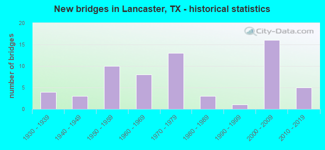
- New bridges - historical statistics
- 41930-1939
- 31940-1949
- 101950-1959
- 81960-1969
- 131970-1979
- 31980-1989
- 11990-1999
- 162000-2009
- 52010-2019

- Reconstructed bridges - Historical Statistics
- 11950-1959
- 11960-1969
- 11970-1979
- 01980-1989
- 21990-1999
- 22000-2009


- Bridge Condition - Deck
- 3.1%Very good
- 56.3%Good
- 34.4%Satisfactory
- 6.3%Fair

- Bridge Condition - Superstructure
- 15.6%Very good
- 43.8%Good
- 31.3%Satisfactory
- 9.4%Fair

- Bridge Condition - Substructure
- 56.3%Good
- 37.5%Satisfactory
- 3.1%Fair
- 3.1%Poor

- Bridge Condition - Channel
- 6.5%Very good
- 19.6%Good
- 41.3%Satisfactory
- 28.3%Fair
- 2.2%Poor
- 2.2%Serious

- Bridge Condition - Culverts
- 40.9%Good
- 54.5%Satisfactory
- 4.5%Fair
Find on map >> Show street view
Structure Number: 180570M00725002, Location: 0.60 MI S OF BELT LINE (Lat: 32.577336, Lng: -96.746189), Route carried "on" structure: City street 263, Year Built: 1952, Status: Open, Structure Length: 3.87m (12.70ft), Average Daily Traffic: 1,800 (year 2011), Average Future Daily Traffic: 2,900 (year 2031), Features Intersected: TEN MILE CREEK, Facility Carried by Structure: NOKOMIS RD
Minimum Vertical Clearance: 30+ m (98+ ft), Kilometerpoint: 1.658, Lanes on structure: 2, Owner: City or Municipal Highway Agency, Approaching Roadway Width: 7.3m (24.0ft), Material/Design: Concrete continuous, Design/Construction: Slab, Number Of Spans In Main Unit: 3, Number Of Approach Spans: 1, Length of Maximum Span: 12.5m (41.0ft), Curb-To-Curb Width: 7.3m (24.0ft), Out-to-Out Width: 8.2m (26.9ft)
Condition: Deck: Good, Superstructure: Good, Substructure: Good, Channel: Good, Operating Rating: 32.7 metric tons, Method Used To Determine Operating Rating: Field evaluation and documented engineering judgment, Inventory Rating: 24.5 metric tons, Method Used To Determine Inventory Rating: Field evaluation and documented engineering judgment, Structural Evaluation: Equal to present minimum criteria, Deck Geometry: Meets minimum limits, Waterway Adequacy: Equal to present minimum criteria, Approach Roadway Alignment: Equal to present desirable criteria, Designated Inspection Frequency: Every 24 months, Inspection Date: May 2021, Deck Structure Type: Concrete Cast-file-Place, Wearing Surface/Protective System: Wearing Surface: Bituminous
Find on map >> Show street view
Structure Number: 180570M00780001, Location: 0.10 MI E OF IH 35 (Lat: 32.575208, Lng: -96.820678), Route carried "on" structure: City street 258, Year Built: 1973, Status: Open, Structure Length: 2.77m (9.09ft), Average Daily Traffic: 739 (year 2020), Average Future Daily Traffic: 300 (year 2031), Design Load: H 15, Features Intersected: TEN MILE CRK TRIB, Facility Carried by Structure: PARKERVILLE RD
Minimum Vertical Clearance: 30+ m (98+ ft), Kilometerpoint: 0.177, Lanes on structure: 2, Owner: City or Municipal Highway Agency, Approaching Roadway Width: 6.7m (22.0ft), Material/Design: Concrete, Design/Construction: Stringer/Multi-beam, Number Of Spans In Main Unit: 3, Length of Maximum Span: 9.1m (29.9ft), Curb-To-Curb Width: 7.9m (25.9ft), Out-to-Out Width: 8.6m (28.2ft)
Condition: Deck: Good, Superstructure: Good, Substructure: Good, Channel: Satisfactory, Operating Rating: 62.6 metric tons, Method Used To Determine Operating Rating: Load Factor (LF), Inventory Rating: 37.2 metric tons, Method Used To Determine Inventory Rating: Load Factor (LF), Structural Evaluation: Better than present minimum criteria, Deck Geometry: Somewhat better than minimum adequacy, Waterway Adequacy: Equal to present minimum criteria, Approach Roadway Alignment: Equal to present desirable criteria, Designated Inspection Frequency: Every 24 months, Inspection Date: April 2021, Deck Structure Type: Concrete Cast-file-Place
Find on map >> Show street view
Structure Number: 180570M00850008, Location: 0.30 MI E OF IH 35E (Lat: 32.604219, Lng: -96.817483), Route carried "on" structure: City street 257, Year Built: 1972, Status: Open, Structure Length: 0.64m (2.10ft), Average Daily Traffic: 4,150 (year 2011), Average Future Daily Traffic: 6,700 (year 2031), Features Intersected: TEN MILE CREEK TRIBUTARY, Facility Carried by Structure: PLEASANT RUN RD
Minimum Vertical Clearance: 30+ m (98+ ft), Kilometerpoint: 13.486, Lanes on structure: 4, Owner: City or Municipal Highway Agency, Approaching Roadway Width: 14.6m (47.9ft), Skew: 30 degrees, Material/Design: Concrete, Design/Construction: Culvert, Number Of Spans In Main Unit: 2, Length of Maximum Span: 3.0m (9.8ft), Curb or Sidewalk Widths: Left: 0.0m, Right: 1.5m (4.9ft)
Condition: Channel: Fair, Culverts: Satisfactory, Operating Rating: 32.7 metric tons, Method Used To Determine Operating Rating: Field evaluation and documented engineering judgment, Inventory Rating: 24.5 metric tons, Method Used To Determine Inventory Rating: Field evaluation and documented engineering judgment, Structural Evaluation: Equal to present minimum criteria, Waterway Adequacy: Equal to present minimum criteria, Approach Roadway Alignment: Equal to present desirable criteria, Designated Inspection Frequency: Every 24 months, Inspection Date: April 2021
Find on map >> Show street view
Structure Number: 180570M00850009, Location: 0.10 MI E OF HOUSTON SCH (Lat: 32.604206, Lng: -96.803828), Route carried "on" structure: City street 257, Year Built: 1969, Status: Open, Structure Length: 2.77m (9.09ft), Average Daily Traffic: 4,150 (year 2011), Average Future Daily Traffic: 6,700 (year 2031), Features Intersected: MILL BRANCH, Facility Carried by Structure: PLEASANT RUN RD
Minimum Vertical Clearance: 30+ m (98+ ft), Kilometerpoint: 14.613, Lanes on structure: 4, Owner: City or Municipal Highway Agency, Approaching Roadway Width: 14.6m (47.9ft), Skew: 20 degrees, Material/Design: Concrete, Design/Construction: Stringer/Multi-beam, Number Of Spans In Main Unit: 3, Length of Maximum Span: 9.1m (29.9ft), Curb-To-Curb Width: 14.5m (47.6ft), Out-to-Out Width: 29.6m (97.1ft)
Condition: Deck: Satisfactory, Superstructure: Satisfactory, Substructure: Good, Channel: Satisfactory, Operating Rating: 32.7 metric tons, Method Used To Determine Operating Rating: Field evaluation and documented engineering judgment, Inventory Rating: 24.5 metric tons, Method Used To Determine Inventory Rating: Field evaluation and documented engineering judgment, Structural Evaluation: Equal to present minimum criteria, Deck Geometry: High priority of replacement, Waterway Adequacy: Equal to present minimum criteria, Approach Roadway Alignment: Equal to present desirable criteria, Length Of Structure Improvement: 2.77m (9.09ft), Designated Inspection Frequency: Every 24 months, Inspection Date: April 2021, Bridge Improvement Cost: $9,000, Roadway Improvement Cost: $2,000, Total Project Cost: $11,000, Deck Structure Type: Concrete Cast-file-Place
Find on map >> Show street view
Structure Number: 180570M0085001, Location: 0.30 MI E OF BLUEGROVE (Lat: 32.604589, Lng: -96.782694), Route carried "on" structure: City street , Year Built: 1969, Status: Open, Structure Length: 2.77m (9.09ft), Average Daily Traffic: 4,150 (year 2011), Average Future Daily Traffic: 5,800 (year 2031), Features Intersected: DEEP BRANCH, Facility Carried by Structure: PLEASANT RUN RD
Minimum Vertical Clearance: 30+ m (98+ ft), Kilometerpoint: 17.703, Lanes on structure: 4, Owner: City or Municipal Highway Agency, Approaching Roadway Width: 14.6m (47.9ft), Skew: 20 degrees, Material/Design: Concrete, Design/Construction: Stringer/Multi-beam, Number Of Spans In Main Unit: 3, Length of Maximum Span: 9.1m (29.9ft), Curb or Sidewalk Widths: Left: 2.8m (9.2ft), Right: 2.8m (9.2ft), Curb-To-Curb Width: 14.5m (47.6ft), Out-to-Out Width: 29.6m (97.1ft)
Condition: Deck: Satisfactory, Superstructure: Good, Substructure: Good, Channel: Satisfactory, Operating Rating: 32.7 metric tons, Method Used To Determine Operating Rating: Field evaluation and documented engineering judgment, Inventory Rating: 24.5 metric tons, Method Used To Determine Inventory Rating: Field evaluation and documented engineering judgment, Structural Evaluation: Equal to present minimum criteria, Deck Geometry: High priority of replacement, Waterway Adequacy: Equal to present minimum criteria, Approach Roadway Alignment: Equal to present desirable criteria, Length Of Structure Improvement: 2.77m (9.09ft), Designated Inspection Frequency: Every 24 months, Inspection Date: Febuary 2021, Bridge Improvement Cost: $9,000, Roadway Improvement Cost: $2,000, Total Project Cost: $11,000, Deck Structure Type: Concrete Cast-file-Place
Find on map >> Show street view
Structure Number: 180570M00850011, Location: 0.05 MI W OF JEFFERSON (Lat: 32.603925, Lng: -96.753636), Route carried "on" structure: City street , Year Built: 1965, Status: Open, Structure Length: 0.64m (2.10ft), Average Daily Traffic: 6,427 (year 2019), Average Future Daily Traffic: 6,000 (year 2031), Features Intersected: KELLER BRANCH, Facility Carried by Structure: PLEASANT RUN RD
Minimum Vertical Clearance: 30+ m (98+ ft), Kilometerpoint: 20.600, Lanes on structure: 2, Owner: City or Municipal Highway Agency, Approaching Roadway Width: 13.4m (44.0ft), Material/Design: Concrete, Design/Construction: Culvert, Number Of Spans In Main Unit: 2, Length of Maximum Span: 3.0m (9.8ft), Curb or Sidewalk Widths: Left: 0.0m, Right: 1.5m (4.9ft), Curb-To-Curb Width: 13.4m (44.0ft), Out-to-Out Width: 19.4m (63.6ft)
Condition: Channel: Fair, Culverts: Good, Operating Rating: 32.7 metric tons, Method Used To Determine Operating Rating: Field evaluation and documented engineering judgment, Inventory Rating: 24.5 metric tons, Method Used To Determine Inventory Rating: Field evaluation and documented engineering judgment, Structural Evaluation: Equal to present minimum criteria, Deck Geometry: Equal to present minimum criteria, Waterway Adequacy: Equal to present minimum criteria, Approach Roadway Alignment: Equal to present desirable criteria, Designated Inspection Frequency: Every 24 months, Inspection Date: Febuary 2021, Deck Structure Type: Concrete Cast-file-Place, Wearing Surface/Protective System: Wearing Surface: Bituminous
Find on map >> Show street view
Structure Number: 180570M00900001, Location: 0.10 MI S OF SH 342 (Lat: 32.578253, Lng: -96.757428), Route carried "on" structure: City street , Year Built: 1936, Status: Posted for load, Structure Length: 5.18m (16.99ft), Average Daily Traffic: 290 (year 2011), Average Future Daily Traffic: 380 (year 2031), Features Intersected: TEN MILE CREEK, Facility Carried by Structure: RED OAK RD
Minimum Vertical Clearance: 30+ m (98+ ft), Kilometerpoint: 0.241, Lanes on structure: 1, Owner: City or Municipal Highway Agency, Approaching Roadway Width: 4.9m (16.1ft), Material/Design: Steel, Design/Construction: Truss - Thru, Number Of Spans In Main Unit: 1, Number Of Approach Spans: 2, Length of Maximum Span: 24.4m (80.1ft), Curb-To-Curb Width: 6.1m (20.0ft), Out-to-Out Width: 7.0m (23.0ft)
Condition: Deck: Very good, Superstructure: Fair, Substructure: Good, Channel: Good, Operating Rating: 26.3 metric tons, Method Used To Determine Operating Rating: Allowable Stress (AS), Inventory Rating: 16.3 metric tons, Method Used To Determine Inventory Rating: Allowable Stress (AS), Structural Evaluation: Somewhat better than minimum adequacy, Deck Geometry: Meets minimum limits, Waterway Adequacy: Better than present minimum criteria, Approach Roadway Alignment: Equal to present desirable criteria, Bridge Posting: Required (Relationship of Operating Rating to Maximum Legal Load: 20.0 - 29.9% below), Length Of Structure Improvement: 5.30m (17.39ft), Designated Inspection Frequency: Every 24 months, Critical Feature Inspection Frequency: Every 24 months, Inspection Date: April 2021, Critical Feature Inspection Date: December 2019, Bridge Improvement Cost: $12,000, Roadway Improvement Cost: $3,000, Total Project Cost: $15,000, Deck Structure Type: Concrete Cast-file-Place
Find on map >> Show street view
Structure Number: 180570M01075001, Location: 0.1 MI W OF SH 342 (Lat: 32.626386, Lng: -96.773794), Route carried "on" structure: City street , Year Built: 1979, Status: Open, Structure Length: 0.64m (2.10ft), Average Daily Traffic: 1,000 (year 2011), Average Future Daily Traffic: 1,500 (year 2031), Features Intersected: NEWTON CREEK TRIB, Facility Carried by Structure: TELEPHONE RD
Minimum Vertical Clearance: 30+ m (98+ ft), Kilometerpoint: 1.883, Lanes on structure: 2, Owner: City or Municipal Highway Agency, Approaching Roadway Width: 7.3m (24.0ft), Material/Design: Concrete, Design/Construction: Culvert, Number Of Spans In Main Unit: 2, Length of Maximum Span: 3.0m (9.8ft), Curb-To-Curb Width: 7.4m (24.3ft), Out-to-Out Width: 7.9m (25.9ft)
Condition: Channel: Satisfactory, Culverts: Satisfactory, Operating Rating: 32.7 metric tons, Method Used To Determine Operating Rating: Field evaluation and documented engineering judgment, Inventory Rating: 24.5 metric tons, Method Used To Determine Inventory Rating: Field evaluation and documented engineering judgment, Structural Evaluation: Equal to present minimum criteria, Deck Geometry: Meets minimum limits, Waterway Adequacy: Better than present minimum criteria, Approach Roadway Alignment: Equal to present desirable criteria, Designated Inspection Frequency: Every 24 months, Inspection Date: April 2021, Deck Structure Type: Concrete Cast-file-Place, Wearing Surface/Protective System: Wearing Surface: Bituminous
Find on map >> Show street view
Structure Number: 180570M01200001, Location: 0.10 MI SW OF AMES RD (Lat: 32.618200, Lng: -96.790489), Route carried "on" structure: City street , Year Built: 1940, Status: Open, Structure Length: 0.73m (2.40ft), Average Daily Traffic: 510 (year 2011), Average Future Daily Traffic: 1,530 (year 2031), Features Intersected: DEEP BRANCH CREEK, Facility Carried by Structure: WINTERGREEN RD
Minimum Vertical Clearance: 30+ m (98+ ft), Kilometerpoint: 3.541, Lanes on structure: 2, Owner: City or Municipal Highway Agency, Approaching Roadway Width: 6.7m (22.0ft), Skew: 3 degrees, Material/Design: Concrete, Design/Construction: Culvert, Number Of Spans In Main Unit: 2, Length of Maximum Span: 3.0m (9.8ft), Curb-To-Curb Width: 7.3m (24.0ft), Out-to-Out Width: 8.2m (26.9ft)
Condition: Channel: Satisfactory, Culverts: Satisfactory, Operating Rating: 32.7 metric tons, Method Used To Determine Operating Rating: Field evaluation and documented engineering judgment, Inventory Rating: 24.5 metric tons, Method Used To Determine Inventory Rating: Field evaluation and documented engineering judgment, Structural Evaluation: Equal to present minimum criteria, Deck Geometry: Meets minimum limits, Waterway Adequacy: Better than present minimum criteria, Approach Roadway Alignment: Equal to present desirable criteria, Length Of Structure Improvement: 0.79m (2.59ft), Designated Inspection Frequency: Every 24 months, Inspection Date: April 2021, Bridge Improvement Cost: $12,000, Roadway Improvement Cost: $3,000, Total Project Cost: $15,000, Deck Structure Type: Concrete Cast-file-Place, Wearing Surface/Protective System: Wearing Surface: Bituminous
Find on map >> Show street view
Structure Number: 180570M01200004, Location: 0.70 MI E OF IH 35E (Lat: 32.618744, Lng: -96.810706), Route carried "on" structure: City street 256, Year Built: 1940, Status: Open, Structure Length: 0.70m (2.30ft), Average Daily Traffic: 630 (year 2011), Average Future Daily Traffic: 1,130 (year 2031), Features Intersected: MILL CREEK, Facility Carried by Structure: WINTERGREEN RD
Minimum Vertical Clearance: 30+ m (98+ ft), Kilometerpoint: 1.175, Lanes on structure: 2, Owner: City or Municipal Highway Agency, Approaching Roadway Width: 6.7m (22.0ft), Material/Design: Concrete, Design/Construction: Culvert, Number Of Spans In Main Unit: 2, Length of Maximum Span: 3.0m (9.8ft), Curb-To-Curb Width: 10.4m (34.1ft), Out-to-Out Width: 10.9m (35.8ft)
Condition: Channel: Satisfactory, Culverts: Good, Operating Rating: 32.7 metric tons, Method Used To Determine Operating Rating: Field evaluation and documented engineering judgment, Inventory Rating: 24.5 metric tons, Method Used To Determine Inventory Rating: Field evaluation and documented engineering judgment, Structural Evaluation: Equal to present minimum criteria, Deck Geometry: Equal to present minimum criteria, Waterway Adequacy: Equal to present minimum criteria, Approach Roadway Alignment: Equal to present desirable criteria, Designated Inspection Frequency: Every 24 months, Inspection Date: April 2021, Deck Structure Type: Concrete Cast-file-Place, Wearing Surface/Protective System: Wearing Surface: Bituminous
Find on map >> Show street view
Structure Number: 180570M01225001, Location: 0.30 MI E OF DALLAS AVE (Lat: 32.593519, Lng: -96.750767), Route carried "on" structure: City street , Year Built: 1958, Status: Open, Structure Length: 1.13m (3.71ft), Average Daily Traffic: 530 (year 2011), Average Future Daily Traffic: 950 (year 2031), Features Intersected: KELLER BRANCH, Facility Carried by Structure: SECOND ST
Minimum Vertical Clearance: 30+ m (98+ ft), Kilometerpoint: 0.483, Lanes on structure: 2, Owner: City or Municipal Highway Agency, Approaching Roadway Width: 7.3m (24.0ft), Skew: 3 degrees, Material/Design: Concrete, Design/Construction: Culvert, Number Of Spans In Main Unit: 3, Length of Maximum Span: 3.0m (9.8ft)
Condition: Channel: Satisfactory, Culverts: Satisfactory, Operating Rating: 32.7 metric tons, Method Used To Determine Operating Rating: Field evaluation and documented engineering judgment, Inventory Rating: 24.5 metric tons, Method Used To Determine Inventory Rating: Field evaluation and documented engineering judgment, Structural Evaluation: Equal to present minimum criteria, Waterway Adequacy: Better than present minimum criteria, Approach Roadway Alignment: Equal to present desirable criteria, Designated Inspection Frequency: Every 24 months, Inspection Date: April 2021
Find on map >> Show street view
Structure Number: 180570M01255001, Location: 0.05 MI E OF N ELM ST (Lat: 32.599933, Lng: -96.760933), Route carried "on" structure: City street , Year Built: 1957, Year Reconstructed: 1975, Status: Open, Structure Length: 1.07m (3.51ft), Average Daily Traffic: 2,030 (year 2011), Average Future Daily Traffic: 3,500 (year 2031), Features Intersected: HALLS BRANCH CREEK, Facility Carried by Structure: EIGHTH ST
Minimum Vertical Clearance: 30+ m (98+ ft), Kilometerpoint: 0.660, Lanes on structure: 2, Owner: City or Municipal Highway Agency, Approaching Roadway Width: 10.7m (35.1ft), Skew: 3 degrees, Material/Design: Concrete, Design/Construction: Culvert, Number Of Spans In Main Unit: 4, Length of Maximum Span: 2.4m (7.9ft), Curb-To-Curb Width: 10.9m (35.8ft), Out-to-Out Width: 14.4m (47.2ft)
Condition: Channel: Satisfactory, Culverts: Satisfactory, Operating Rating: 32.7 metric tons, Method Used To Determine Operating Rating: Field evaluation and documented engineering judgment, Inventory Rating: 24.5 metric tons, Method Used To Determine Inventory Rating: Field evaluation and documented engineering judgment, Structural Evaluation: Equal to present minimum criteria, Deck Geometry: Somewhat better than minimum adequacy, Waterway Adequacy: Better than present minimum criteria, Approach Roadway Alignment: Equal to present desirable criteria, Designated Inspection Frequency: Every 24 months, Inspection Date: April 2021, Deck Structure Type: Concrete Cast-file-Place, Wearing Surface/Protective System: Wearing Surface: Bituminous
Find on map >> Show street view
Structure Number: 180570044202085, Location: 0.6 Mi S of IH 20 (Lat: 32.633183, Lng: -96.822978), Route carried "under" structure: City street , Year Built: 2004, Structure Length: 0. m, Average Daily Traffic: 985 (year 2016), Features Intersected: Danieldale Rd, Facility Carried by Structure: IH 35E NB
Minimum Vertical Clearance: 5.43m (17.81ft), Kilometerpoint: 3.505, Lanes on structure: 5, Lanes under structure: 5, Material/Design: Prestressed concrete, Design/Construction: Stringer/Multi-beam, Length of Maximum Span: 37.5m (123.0ft)
Find on map >> Show street view
Structure Number: 180570044202087, Location: 1.6 Mi S of IH 20 (Lat: 32.618375, Lng: -96.822781), Route carried "under" structure: Alternate City street , Year Built: 2004, Structure Length: 0. m, Average Daily Traffic: 17,284 (year 2020), Truck Traffic: 3%, Features Intersected: Wintergreen Rd, Facility Carried by Structure: IH 35E NB
Minimum Vertical Clearance: 5.26m (17.26ft), Kilometerpoint: 12.040, Lanes on structure: 5, Lanes under structure: 7, Material/Design: Prestressed concrete, Design/Construction: Stringer/Multi-beam, Length of Maximum Span: 37.5m (123.0ft)
Find on map >> Show street view
Structure Number: 180570044202092, Location: 3.6 Mi S of IH 20 (Lat: 32.588897, Lng: -96.822167), Route carried "under" structure: City street , Year Built: 2005, Structure Length: 0. m, Average Daily Traffic: 18,303 (year 2020), Truck Traffic: 3%, Features Intersected: Ten Mile Ck & BeltlineRd, Facility Carried by Structure: IH 35E NBML
Minimum Vertical Clearance: 5.56m (18.24ft), Kilometerpoint: 4.828, Lanes on structure: 4, Lanes under structure: 8, Material/Design: Prestressed concrete, Design/Construction: Stringer/Multi-beam, Length of Maximum Span: 40.2m (131.9ft)
Find on map >> Show street view
Structure Number: 180570044202346, Location: 5.6 MI S OF IH 20 (Lat: 32.560417, Lng: -96.822297), Route carried "under" structure: City street , Year Built: 2008, Structure Length: 0. m, Average Daily Traffic: 12,521 (year 2014), Truck Traffic: 3%, Features Intersected: BEAR CREEK RD, Facility Carried by Structure: IH 35E NB
Minimum Vertical Clearance: 5.49m (18.01ft), Kilometerpoint: 0.000, Lanes on structure: 3, Lanes under structure: 4, Material/Design: Prestressed concrete, Design/Construction: Stringer/Multi-beam, Length of Maximum Span: 36.0m (118.1ft)
Find on map >> Show street view
Structure Number: 180570044202349, Location: 4.6 Mi S of IH 20 (Lat: 32.574772, Lng: -96.822183), Route carried "under" structure: City street , Year Built: 2010, Structure Length: 0. m, Average Daily Traffic: 14,026 (year 2020), Truck Traffic: 3%, Features Intersected: Parkerville Rd, Facility Carried by Structure: IH 35E NB
Minimum Vertical Clearance: 6.65m (21.82ft), Kilometerpoint: 1.456, Lanes on structure: 3, Lanes under structure: 2, Material/Design: Prestressed concrete, Design/Construction: Stringer/Multi-beam, Length of Maximum Span: 36.0m (118.1ft)
Find on map >> Show street view
Structure Number: 180570237403146, Location: 1.0 MI E OF IH 35E (Lat: 32.641908, Lng: -96.805592), Route carried "under" structure: Alternate City street , Year Built: 1971, Structure Length: 0. m, Average Daily Traffic: 1,273 (year 2011), Features Intersected: IH 20 EB, Facility Carried by Structure: IH 20 EBML
Minimum Vertical Clearance: 4.88m (16.01ft), Kilometerpoint: 116.566, Lanes on structure: 8, Material/Design: Steel continuous, Design/Construction: Stringer/Multi-beam, Length of Maximum Span: 29.3m (96.1ft)
Find on map >> Show street view
Structure Number: 180570237403147, Location: 1.0 MI E OF IH 35E (Lat: 32.642458, Lng: -96.805847), Route carried "under" structure: Alternate City street , Year Built: 1971, Structure Length: 0. m, Average Daily Traffic: 775 (year 2011), Features Intersected: IH 20 WBML, Facility Carried by Structure: IH 20 WBML
Minimum Vertical Clearance: 5.79m (19.00ft), Kilometerpoint: 116.566, Lanes on structure: 8, Material/Design: Steel continuous, Design/Construction: Stringer/Multi-beam, Length of Maximum Span: 29.3m (96.1ft)
Find on map >> Show street view
Structure Number: 180570237403157, Location: 0.7 MI E OF IH 35E (Lat: 32.641392, Lng: -96.811694), Route carried "under" structure: Ramp Interstate 20, Year Built: 2008, Structure Length: 0. m, Average Daily Traffic: 1,000 (year 2011), Truck Traffic: 10%, Features Intersected: IH 20 EB ON RAMP
Minimum Vertical Clearance: 5.49m (18.01ft), Kilometerpoint: 23.360, Lanes on structure: 1, Material/Design: Prestressed concrete, Design/Construction: Stringer/Multi-beam, Length of Maximum Span: 39.6m (129.9ft)
Find on map >> Show street view
Structure Number: 180570237403183, Location: AT IH 20 INTERCHANGE (Lat: 32.642014, Lng: -96.823389), Route carried "under" structure: Interstate 20, Year Built: 1974, Structure Length: 0. m, Average Daily Traffic: 311,226 (year 2020), Truck Traffic: 16%, Features Intersected: IH 35E CONN D, Facility Carried by Structure: IH 35E NB CONN D
Minimum Vertical Clearance: 30+ m (98+ ft), Kilometerpoint: 0.000, Lanes on structure: 12, Material/Design: Steel continuous, Design/Construction: Girder and Floorbeam System, Length of Maximum Span: 47.2m (154.9ft)