Bridge Statistics for Laramie, Wyoming (WY)
Condition, Traffic, Stress, Structural Evaluation, Project Costs
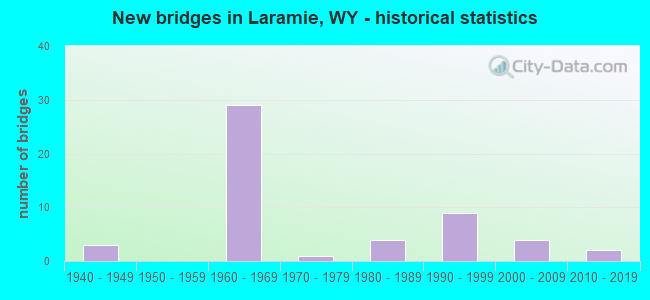
- New bridges - historical statistics
- 31940-1949
- 291960-1969
- 11970-1979
- 41980-1989
- 91990-1999
- 42000-2009
- 22010-2019

- Reconstructed bridges - Historical Statistics
- 31970-1979
- 01980-1989
- 21990-1999
- 22000-2009
- 12010-2019


- Bridge Condition - Deck
- 3.7%Very good
- 25.9%Good
- 44.4%Satisfactory
- 22.2%Fair
- 3.7%Poor

- Bridge Condition - Superstructure
- 7.4%Very good
- 48.1%Good
- 25.9%Satisfactory
- 14.8%Fair
- 3.7%Poor

- Bridge Condition - Substructure
- 51.9%Good
- 29.6%Satisfactory
- 11.1%Fair
- 3.7%Poor
- 3.7%Critical

- Bridge Condition - Channel
- 31.6%Very good
- 21.1%Good
- 47.4%Satisfactory

- Bridge Condition - Culverts
- 8.3%Very good
- 25.0%Good
- 58.3%Satisfactory
- 8.3%Fair
Find on map >> Show street view
Structure Number: AXQ, Location: Laramie (Lat: 41.291436, Lng: -105.538211), Route carried "under" structure: Interstate 80, Year Built: 1962, Structure Length: 0. m, Average Daily Traffic: 8,086 (year 2021), Truck Traffic: 44%, Features Intersected: I-80, Facility Carried by Structure: Vista Drive
Minimum Vertical Clearance: 5.21m (17.09ft), Kilometerpoint: 508.368, Lanes on structure: 2, Lanes under structure: 2, Material/Design: Concrete continuous, Design/Construction: Tee Beam, Length of Maximum Span: 17.1m (56.1ft)
Find on map >> Show street view
Structure Number: CLS, Location: Laramie Grand Ave Intg (Lat: 41.291278, Lng: -105.528683), Route carried "under" structure: Interstate 80, Year Built: 1962, Structure Length: 0. m, Average Daily Traffic: 8,086 (year 2021), Truck Traffic: 44%, Features Intersected: I-80
Minimum Vertical Clearance: 6.00m (19.69ft), Kilometerpoint: 509.163, Lanes on structure: 1, Lanes under structure: 2, Material/Design: Concrete continuous, Design/Construction: Tee Beam, Length of Maximum Span: 19.2m (63.0ft)
Find on map >> Show street view
Structure Number: CLS, Location: Laramie Grand Ave Intg (Lat: 41.291278, Lng: -105.528683), Route carried "under" structure: Interstate 80, Year Built: 1962, Structure Length: 0. m, Average Daily Traffic: 10,578 (year 2021), Truck Traffic: 63%, Features Intersected: I-80
Minimum Vertical Clearance: 8.00m (26.25ft), Kilometerpoint: 509.398, Lanes on structure: 1, Lanes under structure: 2, Material/Design: Concrete continuous, Design/Construction: Tee Beam, Length of Maximum Span: 19.2m (63.0ft)
Find on map >> Show street view
Structure Number: CXZ, Location: Curtis Street Laramie (Lat: 41.327908, Lng: -105.616247), Route carried "under" structure: Interstate 80, Year Built: 1969, Structure Length: 0. m, Average Daily Traffic: 6,427 (year 2021), Truck Traffic: 56%, Features Intersected: I-80
Minimum Vertical Clearance: 5.34m (17.52ft), Kilometerpoint: 499.339, Lanes on structure: 2, Lanes under structure: 2, Material/Design: Concrete continuous, Design/Construction: Box Beam or Girders - Multiple, Length of Maximum Span: 31.6m (103.7ft)
Find on map >> Show street view
Structure Number: CXZ, Location: Curtis Street Laramie (Lat: 41.327908, Lng: -105.616247), Route carried "under" structure: Interstate 80, Year Built: 1969, Structure Length: 0. m, Average Daily Traffic: 7,321 (year 2021), Truck Traffic: 44%, Features Intersected: I-80
Minimum Vertical Clearance: 5.31m (17.42ft), Kilometerpoint: 499.133, Lanes on structure: 2, Lanes under structure: 2, Material/Design: Concrete continuous, Design/Construction: Box Beam or Girders - Multiple, Length of Maximum Span: 31.6m (103.7ft)
Find on map >> Show street view
Structure Number: KLH, Location: Laramie Marginal (Lat: 41.309225, Lng: -105.614336), Route carried "under" structure: State highway 130, Year Built: 1997, Structure Length: 0. m, Average Daily Traffic: 4,943 (year 2021), Truck Traffic: 11%, Features Intersected: Snowy Range Road, Facility Carried by Structure: I-80 EBL
Minimum Vertical Clearance: 5.21m (17.09ft), Kilometerpoint: 161.049, Lanes on structure: 2, Lanes under structure: 5, Material/Design: Steel continuous, Design/Construction: Stringer/Multi-beam, Length of Maximum Span: 28.7m (94.2ft)
Find on map >> Show street view
Structure Number: KLI, Location: Laramie Marginal (Lat: 41.309233, Lng: -105.614086), Route carried "under" structure: State highway 130, Year Built: 1997, Structure Length: 0. m, Average Daily Traffic: 9,924 (year 2021), Truck Traffic: 5%, Features Intersected: Snowy Range Road, Facility Carried by Structure: I-80 WBL
Minimum Vertical Clearance: 5.21m (17.09ft), Kilometerpoint: 161.070, Lanes on structure: 2, Lanes under structure: 5, Material/Design: Steel continuous, Design/Construction: Stringer/Multi-beam, Length of Maximum Span: 28.7m (94.2ft)
Find on map >> Show street view
Structure Number: LBN, Location: Laramie Maginal (Lat: 41.297536, Lng: -105.595025), Route carried "under" structure: US 30, Year Built: 1999, Structure Length: 0. m, Average Daily Traffic: 2,163 (year 2021), Truck Traffic: 6%, Features Intersected: US 287, Facility Carried by Structure: I-80 EBL
Minimum Vertical Clearance: 5.67m (18.60ft), Kilometerpoint: 529.685, Lanes on structure: 2, Lanes under structure: 5, Material/Design: Steel continuous, Design/Construction: Stringer/Multi-beam, Length of Maximum Span: 34.4m (112.9ft)
Find on map >> Show street view
Structure Number: NFQ, Location: Laramie Grand Ave Intg (Lat: 41.290658, Lng: -105.528522), Route carried "under" structure: Interstate 80, Year Built: 1962, Structure Length: 0. m, Average Daily Traffic: 10,578 (year 2021), Truck Traffic: 63%, Features Intersected: I-80
Minimum Vertical Clearance: 8.00m (26.25ft), Kilometerpoint: 509.427, Lanes on structure: 1, Lanes under structure: 2, Material/Design: Concrete continuous, Design/Construction: Tee Beam, Length of Maximum Span: 19.2m (63.0ft)
Find on map >> Show street view
Structure Number: NFQ, Location: Laramie Grand Ave Intg (Lat: 41.290658, Lng: -105.528522), Route carried "under" structure: Interstate 80, Year Built: 1962, Structure Length: 0. m, Average Daily Traffic: 8,086 (year 2021), Truck Traffic: 44%, Features Intersected: I-80
Minimum Vertical Clearance: 6.00m (19.69ft), Kilometerpoint: 509.195, Lanes on structure: 1, Lanes under structure: 2, Material/Design: Concrete continuous, Design/Construction: Tee Beam, Length of Maximum Span: 19.2m (63.0ft)