Bridge Statistics for Las Cruces, New Mexico (NM)
Condition, Traffic, Stress, Structural Evaluation, Project Costs
- National Bridge Inventory (NBI) Statistics
- 138Number of bridges
- 1,460ft / 445mTotal length
- $3,422,000Total costs
- 1,668,998Total average daily traffic
- 279,746Total average daily truck traffic
- National Bridge Inventory (NBI) Registered Bridges for Las Cruces
- No street view available for this location
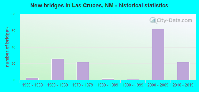
- New bridges - historical statistics
- 31950-1959
- 261960-1969
- 221970-1979
- 21980-1989
- 11990-1999
- 622000-2009
- 222010-2019

- Reconstructed bridges - Historical Statistics
- 11980-1989
- 31990-1999
- 32000-2009
- 32010-2019


- Bridge Condition - Deck
- 79.3%Good
- 19.0%Satisfactory
- 1.7%Fair

- Bridge Condition - Superstructure
- 65.5%Good
- 25.9%Satisfactory
- 3.4%Fair
- 5.2%Poor

- Bridge Condition - Substructure
- 63.8%Good
- 22.4%Satisfactory
- 8.6%Fair
- 5.2%Poor

- Bridge Condition - Channel
- 2.8%Very good
- 36.1%Good
- 19.4%Satisfactory
- 33.3%Fair
- 5.6%Poor
- 2.8%Serious

- Bridge Condition - Culverts
- 40.0%Good
- 40.0%Satisfactory
- 20.0%Fair
Find on map >> Show street view
Structure Number: 9207, Location: 1.3 Mi E o Jct I-25/US-70 (Lat: 32.364417, Lng: -106.749964), Route carried "on" structure: US 70, Year Built: 2003, Status: Open, Structure Length: 3.99m (13.09ft), Average Daily Traffic: 40,474 (year 2020), Truck Traffic: 37%, Average Future Daily Traffic: 69,288 (year 2040), Design Load: HS 20, Features Intersected: Rinconada Road
Minimum Vertical Clearance: 30+ m (98+ ft), Kilometerpoint: 244.459, Lanes on structure: 2, Lanes under structure: 4, Base Highway Network: Yes, Owner: State Highway Agency, Approaching Roadway Width: 11.0m (36.1ft), Material/Design: Steel, Design/Construction: Stringer/Multi-beam, Number Of Spans In Main Unit: 1, Length of Maximum Span: 39.7m (130.2ft), Curb-To-Curb Width: 10.9m (35.8ft), Out-to-Out Width: 11.6m (38.1ft)
Condition: Deck: Good, Superstructure: Good, Substructure: Good, Operating Rating: 55.3 metric tons, Method Used To Determine Operating Rating: Load Factor (LF), Inventory Rating: 32.7 metric tons, Method Used To Determine Inventory Rating: Load Factor (LF), Structural Evaluation: Better than present minimum criteria, Deck Geometry: Meets minimum limits, Underclear: High priority of corrective action, Approach Roadway Alignment: Equal to present desirable criteria, Designated Inspection Frequency: Every 24 months, Inspection Date: July 2020, Deck Structure Type: Concrete Cast-file-Place, Wearing Surface/Protective System: Wearing Surface: Epoxy Overlay, Deck Protection: Epoxy Coated Reinforcing
Find on map >> Show street view
Structure Number: 9208, Location: 2.3 Mi E Jct I-25/US-70 (Lat: 32.372161, Lng: -106.740219), Route carried "on" structure: US 70, Year Built: 2003, Status: Open, Structure Length: 8.53m (27.99ft), Average Daily Traffic: 40,474 (year 2020), Truck Traffic: 37%, Average Future Daily Traffic: 69,288 (year 2040), Design Load: HS 20, Features Intersected: Sonoma Ranch Blvd
Minimum Vertical Clearance: 30+ m (98+ ft), Kilometerpoint: 246.069, Lanes on structure: 2, Lanes under structure: 4, Base Highway Network: Yes, Owner: State Highway Agency, Approaching Roadway Width: 10.9m (35.8ft), Material/Design: Steel continuous, Design/Construction: Stringer/Multi-beam, Number Of Spans In Main Unit: 3, Length of Maximum Span: 36.6m (120.1ft), Curb-To-Curb Width: 10.7m (35.1ft), Out-to-Out Width: 11.7m (38.4ft)
Condition: Deck: Good, Superstructure: Good, Substructure: Good, Operating Rating: 51.8 metric tons, Method Used To Determine Operating Rating: Load Factor (LF), Inventory Rating: 40.5 metric tons, Method Used To Determine Inventory Rating: Load Factor (LF), Structural Evaluation: Better than present minimum criteria, Deck Geometry: Meets minimum limits, Underclear: Somewhat better than minimum adequacy, Approach Roadway Alignment: Equal to present desirable criteria, Designated Inspection Frequency: Every 24 months, Inspection Date: March 2022, Deck Structure Type: Concrete Cast-file-Place, Wearing Surface/Protective System: Deck Protection: Epoxy Coated Reinforcing
Find on map >> Show street view
Structure Number: 9209, Location: 2.3 Mi E of Jct I-25/US70 (Lat: 32.372289, Lng: -106.740356), Route carried "on" structure: US 70, Year Built: 2003, Status: Open, Structure Length: 8.53m (27.99ft), Average Daily Traffic: 40,474 (year 2020), Truck Traffic: 37%, Average Future Daily Traffic: 69,288 (year 2040), Design Load: HS 20, Features Intersected: Sonoma Ranch Blvd
Minimum Vertical Clearance: 30+ m (98+ ft), Kilometerpoint: 246.069, Lanes on structure: 2, Lanes under structure: 4, Base Highway Network: Yes, Owner: State Highway Agency, Approaching Roadway Width: 11.0m (36.1ft), Material/Design: Steel continuous, Design/Construction: Stringer/Multi-beam, Number Of Spans In Main Unit: 3, Length of Maximum Span: 36.6m (120.1ft), Curb-To-Curb Width: 10.8m (35.4ft), Out-to-Out Width: 11.7m (38.4ft)
Condition: Deck: Good, Superstructure: Good, Substructure: Good, Operating Rating: 51.8 metric tons, Method Used To Determine Operating Rating: Load Factor (LF), Inventory Rating: 40.5 metric tons, Method Used To Determine Inventory Rating: Load Factor (LF), Structural Evaluation: Better than present minimum criteria, Deck Geometry: Meets minimum limits, Underclear: Equal to present desirable criteria, Approach Roadway Alignment: Equal to present desirable criteria, Designated Inspection Frequency: Every 24 months, Inspection Date: March 2022, Deck Structure Type: Concrete Cast-file-Place, Wearing Surface/Protective System: Deck Protection: Epoxy Coated Reinforcing
Find on map >> Show street view
Structure Number: 921, Location: 4.1 M E EXIT 6 OF I-25 (Lat: 32.384264, Lng: -106.717333), Route carried "on" structure: US 70, Year Built: 2003, Status: Open, Structure Length: 8.56m (28.08ft), Average Daily Traffic: 40,474 (year 2020), Truck Traffic: 37%, Average Future Daily Traffic: 69,288 (year 2040), Design Load: HS 20, Features Intersected: MESA GRANDE DRIVE
Minimum Vertical Clearance: 30+ m (98+ ft), Kilometerpoint: 248.643, Lanes on structure: 2, Lanes under structure: 10, Base Highway Network: Yes, Owner: State Highway Agency, Approaching Roadway Width: 10.9m (35.8ft), Skew: 2 degrees, Material/Design: Prestressed concrete continuous, Design/Construction: Box Beam or Girders - Single/Spread, Number Of Spans In Main Unit: 3, Length of Maximum Span: 36.6m (120.1ft), Curb-To-Curb Width: 10.8m (35.4ft), Out-to-Out Width: 12.5m (41.0ft)
Condition: Deck: Good, Superstructure: Good, Substructure: Good, Operating Rating: 68.0 metric tons, Method Used To Determine Operating Rating: Load Factor (LF), Inventory Rating: 40.8 metric tons, Method Used To Determine Inventory Rating: Load Factor (LF), Structural Evaluation: Better than present minimum criteria, Deck Geometry: Meets minimum limits, Underclear: High priority of corrective action, Approach Roadway Alignment: Equal to present desirable criteria, Designated Inspection Frequency: Every 24 months, Inspection Date: January 2021, Deck Structure Type: Concrete Cast-file-Place, Wearing Surface/Protective System: Deck Protection: Epoxy Coated Reinforcing
Find on map >> Show street view
Structure Number: 9211, Location: 4.1 M E OF EXIT 6 OF I-25 (Lat: 32.384394, Lng: -106.717394), Route carried "on" structure: US 70, Year Built: 2003, Status: Open, Structure Length: 8.56m (28.08ft), Average Daily Traffic: 23,886 (year 2020), Truck Traffic: 37%, Average Future Daily Traffic: 40,892 (year 2040), Design Load: HS 20, Features Intersected: MESA GRANDE DRIVE
Minimum Vertical Clearance: 30+ m (98+ ft), Kilometerpoint: 248.644, Lanes on structure: 2, Lanes under structure: 10, Base Highway Network: Yes, Owner: State Highway Agency, Approaching Roadway Width: 11.0m (36.1ft), Skew: 2 degrees, Material/Design: Prestressed concrete continuous, Design/Construction: Box Beam or Girders - Single/Spread, Number Of Spans In Main Unit: 3, Length of Maximum Span: 36.6m (120.1ft), Curb-To-Curb Width: 10.9m (35.8ft), Out-to-Out Width: 12.4m (40.7ft)
Condition: Deck: Good, Superstructure: Good, Substructure: Good, Operating Rating: 68.0 metric tons, Method Used To Determine Operating Rating: Load Factor (LF), Inventory Rating: 40.8 metric tons, Method Used To Determine Inventory Rating: Load Factor (LF), Structural Evaluation: Better than present minimum criteria, Deck Geometry: Meets minimum limits, Underclear: Meets minimum limits, Approach Roadway Alignment: Equal to present desirable criteria, Designated Inspection Frequency: Every 24 months, Inspection Date: June 2020, Deck Structure Type: Concrete Cast-file-Place, Wearing Surface/Protective System: Deck Protection: Epoxy Coated Reinforcing
Find on map >> Show street view
Structure Number: 9212, Location: 5.2 M E OF EXIT 6 OF I-25 (Lat: 32.390142, Lng: -106.700222), Route carried "on" structure: US 70, Year Built: 2003, Status: Open, Structure Length: 3.65m (11.98ft), Average Daily Traffic: 23,886 (year 2020), Truck Traffic: 37%, Average Future Daily Traffic: 40,892 (year 2040), Design Load: HS 20, Features Intersected: PORTER DRIVE
Minimum Vertical Clearance: 30+ m (98+ ft), Kilometerpoint: 250.414, Lanes on structure: 2, Lanes under structure: 6, Base Highway Network: Yes, Owner: State Highway Agency, Approaching Roadway Width: 10.9m (35.8ft), Skew: 1 degrees, Material/Design: Prestressed concrete, Design/Construction: Box Beam or Girders - Single/Spread, Number Of Spans In Main Unit: 1, Length of Maximum Span: 35.8m (117.5ft), Curb-To-Curb Width: 10.8m (35.4ft), Out-to-Out Width: 12.3m (40.4ft)
Condition: Deck: Good, Superstructure: Good, Substructure: Good, Operating Rating: 77.1 metric tons, Method Used To Determine Operating Rating: Load Factor (LF), Inventory Rating: 32.7 metric tons, Method Used To Determine Inventory Rating: Load Factor (LF), Structural Evaluation: Better than present minimum criteria, Deck Geometry: Meets minimum limits, Underclear: Superior to present desirable criteria, Approach Roadway Alignment: Equal to present desirable criteria, Designated Inspection Frequency: Every 24 months, Inspection Date: May 2020, Deck Structure Type: Concrete Cast-file-Place, Wearing Surface/Protective System: Deck Protection: Epoxy Coated Reinforcing
Find on map >> Show street view
Structure Number: 9213, Location: 5.2 M E OF EXIT 6 OF I-25 (Lat: 32.390325, Lng: -106.700222), Route carried "on" structure: US 70, Year Built: 2003, Status: Open, Structure Length: 3.65m (11.98ft), Average Daily Traffic: 23,886 (year 2020), Truck Traffic: 37%, Average Future Daily Traffic: 40,892 (year 2040), Design Load: HS 20, Features Intersected: PORTER DRIVE
Minimum Vertical Clearance: 30+ m (98+ ft), Kilometerpoint: 250.414, Lanes on structure: 2, Lanes under structure: 6, Base Highway Network: Yes, Owner: State Highway Agency, Approaching Roadway Width: 10.9m (35.8ft), Skew: 1 degrees, Material/Design: Prestressed concrete, Design/Construction: Box Beam or Girders - Single/Spread, Number Of Spans In Main Unit: 1, Length of Maximum Span: 35.8m (117.5ft), Curb-To-Curb Width: 10.9m (35.8ft), Out-to-Out Width: 12.3m (40.4ft)
Condition: Deck: Good, Superstructure: Good, Substructure: Good, Operating Rating: 77.1 metric tons, Method Used To Determine Operating Rating: Load Factor (LF), Inventory Rating: 34.5 metric tons, Method Used To Determine Inventory Rating: Load Factor (LF), Structural Evaluation: Better than present minimum criteria, Deck Geometry: Meets minimum limits, Underclear: Superior to present desirable criteria, Approach Roadway Alignment: Equal to present desirable criteria, Designated Inspection Frequency: Every 24 months, Inspection Date: May 2020, Deck Structure Type: Concrete Cast-file-Place, Wearing Surface/Protective System: Deck Protection: Epoxy Coated Reinforcing
Find on map >> Show street view
Structure Number: 9214, Location: 6.3 mi east of I-25 Exit (Lat: 32.396050, Lng: -106.683075), Route carried "on" structure: US 70, Year Built: 2003, Status: Open, Structure Length: 3.65m (11.98ft), Average Daily Traffic: 12,521 (year 2020), Truck Traffic: 16%, Average Future Daily Traffic: 9,664 (year 2040), Design Load: HS 20, Features Intersected: Holman Road / Dunn Drive
Minimum Vertical Clearance: 30+ m (98+ ft), Kilometerpoint: 251.862, Lanes on structure: 2, Lanes under structure: 6, Base Highway Network: Yes, Owner: State Highway Agency, Approaching Roadway Width: 10.9m (35.8ft), Material/Design: Prestressed concrete, Design/Construction: Box Beam or Girders - Single/Spread, Number Of Spans In Main Unit: 1, Length of Maximum Span: 35.8m (117.5ft), Curb-To-Curb Width: 10.8m (35.4ft), Out-to-Out Width: 12.6m (41.3ft)
Condition: Deck: Good, Superstructure: Good, Substructure: Good, Operating Rating: 77.1 metric tons, Method Used To Determine Operating Rating: Load Factor (LF), Inventory Rating: 34.5 metric tons, Method Used To Determine Inventory Rating: Load Factor (LF), Structural Evaluation: Better than present minimum criteria, Deck Geometry: Meets minimum limits, Underclear: Better than present minimum criteria, Approach Roadway Alignment: Better than present minimum criteria, Designated Inspection Frequency: Every 24 months, Inspection Date: March 2021, Deck Structure Type: Concrete Cast-file-Place, Wearing Surface/Protective System: Deck Protection: Epoxy Coated Reinforcing
Find on map >> Show street view
Structure Number: 9215, Location: 6.3 mi east of I-25 exit (Lat: 32.396225, Lng: -106.683078), Route carried "on" structure: US 70, Year Built: 2007, Status: Open, Structure Length: 3.65m (11.98ft), Average Daily Traffic: 12,521 (year 2020), Truck Traffic: 16%, Average Future Daily Traffic: 9,664 (year 2040), Design Load: HS 20, Features Intersected: Hollman Road / Dunn Driv
Minimum Vertical Clearance: 30+ m (98+ ft), Kilometerpoint: 251.862, Lanes on structure: 2, Lanes under structure: 6, Base Highway Network: Yes, Owner: State Highway Agency, Approaching Roadway Width: 10.9m (35.8ft), Material/Design: Prestressed concrete, Design/Construction: Box Beam or Girders - Single/Spread, Number Of Spans In Main Unit: 1, Length of Maximum Span: 35.8m (117.5ft), Curb-To-Curb Width: 10.9m (35.8ft), Out-to-Out Width: 12.7m (41.7ft)
Condition: Deck: Good, Superstructure: Good, Substructure: Good, Operating Rating: 77.1 metric tons, Method Used To Determine Operating Rating: Load Factor (LF), Inventory Rating: 34.5 metric tons, Method Used To Determine Inventory Rating: Load Factor (LF), Structural Evaluation: Better than present minimum criteria, Deck Geometry: Meets minimum limits, Underclear: Better than present minimum criteria, Approach Roadway Alignment: Equal to present desirable criteria, Designated Inspection Frequency: Every 24 months, Inspection Date: May 2021, Deck Structure Type: Concrete Cast-file-Place, Wearing Surface/Protective System: Deck Protection: Epoxy Coated Reinforcing
Find on map >> Show street view
Structure Number: 9216, Location: 7.9 mi east of I-25 exit (Lat: 32.404942, Lng: -106.657275), Route carried "on" structure: US 70, Year Built: 2007, Status: Open, Structure Length: 3.65m (11.98ft), Average Daily Traffic: 12,521 (year 2020), Truck Traffic: 16%, Average Future Daily Traffic: 9,664 (year 2040), Design Load: HS 20, Features Intersected: Weisner Road
Minimum Vertical Clearance: 30+ m (98+ ft), Kilometerpoint: 254.437, Lanes on structure: 2, Lanes under structure: 6, Base Highway Network: Yes, Owner: State Highway Agency, Approaching Roadway Width: 11.0m (36.1ft), Material/Design: Prestressed concrete, Design/Construction: Box Beam or Girders - Single/Spread, Number Of Spans In Main Unit: 1, Length of Maximum Span: 35.8m (117.5ft), Curb-To-Curb Width: 10.8m (35.4ft), Out-to-Out Width: 12.7m (41.7ft)
Condition: Deck: Good, Superstructure: Good, Substructure: Satisfactory, Operating Rating: 78.4 metric tons, Method Used To Determine Operating Rating: Load Factor (LF), Inventory Rating: 47.4 metric tons, Method Used To Determine Inventory Rating: Load Factor (LF), Structural Evaluation: Equal to present minimum criteria, Deck Geometry: Meets minimum limits, Underclear: Superior to present desirable criteria, Approach Roadway Alignment: Equal to present desirable criteria, Designated Inspection Frequency: Every 24 months, Inspection Date: March 2021, Deck Structure Type: Concrete Cast-file-Place, Wearing Surface/Protective System: Deck Protection: Epoxy Coated Reinforcing
Find on map >> Show street view
Structure Number: 9217, Location: 7.9 Mi E of I-25 Exit-6 (Lat: 32.405133, Lng: -106.657278), Route carried "on" structure: US 70, Year Built: 2003, Status: Open, Structure Length: 3.65m (11.98ft), Average Daily Traffic: 12,521 (year 2020), Truck Traffic: 16%, Average Future Daily Traffic: 9,664 (year 2040), Design Load: HS 20, Features Intersected: Weisner Road
Minimum Vertical Clearance: 30+ m (98+ ft), Kilometerpoint: 254.437, Lanes on structure: 2, Lanes under structure: 4, Base Highway Network: Yes, Owner: State Highway Agency, Approaching Roadway Width: 11.0m (36.1ft), Skew: 2 degrees, Material/Design: Prestressed concrete, Design/Construction: Box Beam or Girders - Single/Spread, Number Of Spans In Main Unit: 1, Length of Maximum Span: 35.8m (117.5ft), Curb-To-Curb Width: 10.8m (35.4ft), Out-to-Out Width: 12.7m (41.7ft)
Condition: Deck: Good, Superstructure: Good, Substructure: Satisfactory, Operating Rating: 78.4 metric tons, Method Used To Determine Operating Rating: Load Factor (LF), Inventory Rating: 47.4 metric tons, Method Used To Determine Inventory Rating: Load Factor (LF), Structural Evaluation: Equal to present minimum criteria, Deck Geometry: Meets minimum limits, Underclear: Superior to present desirable criteria, Approach Roadway Alignment: Equal to present desirable criteria, Designated Inspection Frequency: Every 24 months, Inspection Date: March 2021, Deck Structure Type: Concrete Cast-file-Place
Find on map >> Show street view
Structure Number: 9264, Location: Junction of I-25 & Lohman (Lat: 32.313828, Lng: -106.747211), Route carried "on" structure: City street 5614, Year Built: 2002, Status: Open, Structure Length: 4.63m (15.19ft), Average Daily Traffic: 11,010 (year 2020), Truck Traffic: 7%, Average Future Daily Traffic: 15,494 (year 2040), Design Load: HS 20, Features Intersected: I-25 NBL and SBL
Minimum Vertical Clearance: 30+ m (98+ ft), Kilometerpoint: 6.458, Lanes on structure: 8, Lanes under structure: 4, Base Highway Network: Yes, Owner: State Highway Agency, Approaching Roadway Width: 41.3m (135.5ft), Skew: 20 degrees, Material/Design: Prestressed concrete continuous, Design/Construction: Stringer/Multi-beam, Number Of Spans In Main Unit: 2, Length of Maximum Span: 22.9m (75.1ft), Curb-To-Curb Width: 47.5m (155.8ft), Out-to-Out Width: 49.3m (161.7ft)
Condition: Deck: Good, Superstructure: Good, Substructure: Good, Operating Rating: 75.3 metric tons, Method Used To Determine Operating Rating: Load Factor (LF), Inventory Rating: 32.7 metric tons, Method Used To Determine Inventory Rating: Load Factor (LF), Structural Evaluation: Better than present minimum criteria, Deck Geometry: Superior to present desirable criteria, Underclear: Equal to present minimum criteria, Approach Roadway Alignment: Equal to present desirable criteria, Designated Inspection Frequency: Every 24 months, Inspection Date: November 2021, Deck Structure Type: Concrete Cast-file-Place, Wearing Surface/Protective System: Deck Protection: Epoxy Coated Reinforcing
Find on map >> Show street view
Structure Number: 9265, Location: 0.1 M W OF I-25 EXIT # 3 (Lat: 32.313592, Lng: -106.748292), Route carried "on" structure: City street 5614, Year Built: 2003, Status: Open, Structure Length: 2.10m (6.89ft), Average Daily Traffic: 20,634 (year 2020), Truck Traffic: 7%, Average Future Daily Traffic: 29,037 (year 2040), Design Load: HS 20, Features Intersected: TRIVIZ DRIVE
Minimum Vertical Clearance: 30+ m (98+ ft), Kilometerpoint: 0.000, Lanes on structure: 4, Lanes under structure: 2, Base Highway Network: Yes, Owner: State Highway Agency, Approaching Roadway Width: 36.1m (118.4ft), Skew: 20 degrees, Material/Design: Prestressed concrete, Design/Construction: Stringer/Multi-beam, Number Of Spans In Main Unit: 1, Length of Maximum Span: 20.6m (67.6ft), Curb-To-Curb Width: 45.2m (148.3ft), Out-to-Out Width: 50.7m (166.3ft)
Condition: Deck: Good, Superstructure: Good, Substructure: Good, Operating Rating: 62.6 metric tons, Method Used To Determine Operating Rating: Load Factor (LF), Inventory Rating: 31.8 metric tons, Method Used To Determine Inventory Rating: Load Factor (LF), Structural Evaluation: Better than present minimum criteria, Deck Geometry: Superior to present desirable criteria, Underclear: High priority of corrective action, Approach Roadway Alignment: Equal to present desirable criteria, Designated Inspection Frequency: Every 24 months, Inspection Date: July 2021, Deck Structure Type: Concrete Cast-file-Place, Wearing Surface/Protective System: Deck Protection: Epoxy Coated Reinforcing
Find on map >> Show street view
Structure Number: 9266, Location: 7.2 Mi E of I-10 Exit 135 (Lat: 32.281269, Lng: -106.770192), Route carried "on" structure: Interstate 10, Year Built: 2004, Status: Open, Structure Length: 19.57m (64.21ft), Average Daily Traffic: 20,900 (year 2020), Truck Traffic: 13%, Average Future Daily Traffic: 38,515 (year 2040), Design Load: HS 20, Features Intersected: NM-101, NM-478, BNSF R/R
Minimum Vertical Clearance: 30+ m (98+ ft), Kilometerpoint: 227.787, Lanes on structure: 2, Lanes under structure: 8, Base Highway Network: Yes, Owner: State Highway Agency, Approaching Roadway Width: 17.1m (56.1ft), Skew: 1 degrees, Material/Design: Prestressed concrete continuous, Design/Construction: Box Beam or Girders - Single/Spread, Number Of Spans In Main Unit: 5, Length of Maximum Span: 42.1m (138.1ft), Curb-To-Curb Width: 15.2m (49.9ft), Out-to-Out Width: 16.2m (53.1ft)
Condition: Deck: Good, Superstructure: Poor, Substructure: Good, Operating Rating: 53.9 metric tons, Method Used To Determine Operating Rating: Load Factor (LF), Inventory Rating: 32.7 metric tons, Method Used To Determine Inventory Rating: Load Factor (LF), Structural Evaluation: Meets minimum limits, Deck Geometry: Superior to present desirable criteria, Underclear: Equal to present minimum criteria, Approach Roadway Alignment: Equal to present desirable criteria, Designated Inspection Frequency: Every 12 months, Inspection Date: April 2021, Deck Structure Type: Concrete Cast-file-Place, Wearing Surface/Protective System: Deck Protection: Epoxy Coated Reinforcing
Find on map >> Show street view
Structure Number: 9267, Location: 7.2 Mi E of I-10 Exit-135 (Lat: 32.281072, Lng: -106.770181), Route carried "on" structure: Interstate 10, Year Built: 2004, Status: Open, Structure Length: 15.54m (50.98ft), Average Daily Traffic: 17,518 (year 2020), Truck Traffic: 13%, Average Future Daily Traffic: 32,283 (year 2040), Design Load: HS 20, Features Intersected: NM-101,NM-478, BNSF RR
Minimum Vertical Clearance: 30+ m (98+ ft), Kilometerpoint: 227.722, Lanes on structure: 3, Lanes under structure: 8, Base Highway Network: Yes, Owner: State Highway Agency, Approaching Roadway Width: 15.2m (49.9ft), Skew: 1 degrees, Material/Design: Prestressed concrete continuous, Design/Construction: Box Beam or Girders - Single/Spread, Number Of Spans In Main Unit: 4, Length of Maximum Span: 42.1m (138.1ft), Curb-To-Curb Width: 15.3m (50.2ft), Out-to-Out Width: 16.2m (53.1ft)
Condition: Deck: Good, Superstructure: Poor, Substructure: Good, Operating Rating: 53.9 metric tons, Method Used To Determine Operating Rating: Load Factor (LF), Inventory Rating: 32.7 metric tons, Method Used To Determine Inventory Rating: Load Factor (LF), Structural Evaluation: Meets minimum limits, Deck Geometry: Meets minimum limits, Underclear: Somewhat better than minimum adequacy, Approach Roadway Alignment: Equal to present desirable criteria, Designated Inspection Frequency: Every 12 months, Inspection Date: April 2021, Deck Structure Type: Concrete Cast-file-Place, Wearing Surface/Protective System: Deck Protection: Epoxy Coated Reinforcing
Find on map >> Show street view
Structure Number: 945, Location: 4.65 MI E OF NM-28 (Lat: 32.296842, Lng: -106.722917), Route carried "on" structure: State highway 101, Year Built: 2008, Status: Open, Structure Length: 3.07m (10.07ft), Average Daily Traffic: 7,128 (year 2020), Truck Traffic: 7%, Average Future Daily Traffic: 10,030 (year 2040), Design Load: HS 20, Features Intersected: DRIPPING SPRINGS TORTUGA
Minimum Vertical Clearance: 30+ m (98+ ft), Kilometerpoint: 7.483, Lanes on structure: 2, Owner: County Highway Agency, Approaching Roadway Width: 18.5m (60.7ft), Material/Design: Concrete, Design/Construction: Culvert, Number Of Spans In Main Unit: 3, Length of Maximum Span: 9.8m (32.2ft)
Condition: Channel: Fair, Culverts: Satisfactory, Operating Rating: 53.5 metric tons, Method Used To Determine Operating Rating: Load Factor (LF), Inventory Rating: 32.4 metric tons, Method Used To Determine Inventory Rating: Load Factor (LF), Structural Evaluation: Equal to present minimum criteria, Waterway Adequacy: Better than present minimum criteria, Approach Roadway Alignment: Equal to present minimum criteria, Designated Inspection Frequency: Every 24 months, Inspection Date: May 2020
Find on map >> Show street view
Structure Number: 949, Location: Jct I-10/I-25 Las Cruces (Lat: 32.259108, Lng: -106.730786), Route carried "on" structure: Interstate 10, Year Built: 2013, Status: Open, Structure Length: 3.41m (11.19ft), Average Daily Traffic: 32,356 (year 2020), Truck Traffic: 13%, Average Future Daily Traffic: 59,627 (year 2040), Design Load: HS 20, Features Intersected: I-25 SB off ramp
Minimum Vertical Clearance: 30.45m (99.90ft), Kilometerpoint: 232.341, Lanes on structure: 2, Lanes under structure: 2, Base Highway Network: Yes, Owner: State Highway Agency, Approaching Roadway Width: 17.7m (58.1ft), Skew: 5 degrees, Material/Design: Prestressed concrete, Design/Construction: Stringer/Multi-beam, Number Of Spans In Main Unit: 1, Length of Maximum Span: 32.5m (106.6ft), Curb-To-Curb Width: 17.8m (58.4ft), Out-to-Out Width: 18.6m (61.0ft)
Condition: Deck: Good, Superstructure: Good, Substructure: Good, Operating Rating: 72.3 metric tons, Method Used To Determine Operating Rating: Load Factor (LF), Inventory Rating: 37.4 metric tons, Method Used To Determine Inventory Rating: Load Factor (LF), Structural Evaluation: Better than present minimum criteria, Deck Geometry: Superior to present desirable criteria, Underclear: Meets minimum limits, Approach Roadway Alignment: Equal to present desirable criteria, Designated Inspection Frequency: Every 24 months, Inspection Date: August 2021, Deck Structure Type: Concrete Cast-file-Place
Find on map >> Show street view
Structure Number: 9505, Location: I-10/I-25 Interchange (Lat: 32.263592, Lng: -106.730958), Route carried "on" structure: Ramp Interstate 1114, Year Built: 2013, Status: Open, Structure Length: 10.36m (33.99ft), Average Daily Traffic: 1,941 (year 2020), Truck Traffic: 13%, Average Future Daily Traffic: 3,577 (year 2040), Design Load: HS 20, Features Intersected: I-25, Facility Carried by Structure: I-10 EB off Ramp
Minimum Vertical Clearance: 30+ m (98+ ft), Kilometerpoint: 0.483, Lanes on structure: 2, Lanes under structure: 4, Base Highway Network: Yes, Owner: State Highway Agency, Approaching Roadway Width: 9.3m (30.5ft), Skew: 2 degrees, Material/Design: Steel continuous, Design/Construction: Stringer/Multi-beam, Number Of Spans In Main Unit: 2, Length of Maximum Span: 55.5m (182.1ft), Curb-To-Curb Width: 9.3m (30.5ft), Out-to-Out Width: 10.1m (33.1ft)
Condition: Deck: Good, Superstructure: Good, Substructure: Good, Operating Rating: 83.9 metric tons, Method Used To Determine Operating Rating: Load Factor (LF), Inventory Rating: 50.3 metric tons, Method Used To Determine Inventory Rating: Load Factor (LF), Structural Evaluation: Better than present minimum criteria, Deck Geometry: Somewhat better than minimum adequacy, Underclear: Equal to present minimum criteria, Approach Roadway Alignment: Equal to present desirable criteria, Designated Inspection Frequency: Every 24 months, Inspection Date: August 2021, Deck Structure Type: Concrete Cast-file-Place, Wearing Surface/Protective System: Deck Protection: Epoxy Coated Reinforcing
Find on map >> Show street view
Structure Number: 9506, Location: I-10/I-25 Interchange (Lat: 32.262211, Lng: -106.733631), Route carried "on" structure: Ramp Interstate 1114, Year Built: 2013, Status: Open, Structure Length: 12.68m (41.60ft), Average Daily Traffic: 1,941 (year 2020), Truck Traffic: 13%, Average Future Daily Traffic: 3,577 (year 2040), Design Load: HS 20, Features Intersected: I-10, Facility Carried by Structure: I-10 EB off Ramp
Minimum Vertical Clearance: 30+ m (98+ ft), Kilometerpoint: 0.885, Lanes on structure: 1, Lanes under structure: 4, Base Highway Network: Yes, Owner: State Highway Agency, Approaching Roadway Width: 9.3m (30.5ft), Skew: 2 degrees, Material/Design: Steel continuous, Design/Construction: Stringer/Multi-beam, Number Of Spans In Main Unit: 2, Length of Maximum Span: 64.0m (210.0ft), Curb-To-Curb Width: 9.3m (30.5ft), Out-to-Out Width: 10.0m (32.8ft)
Condition: Deck: Good, Superstructure: Good, Substructure: Good, Operating Rating: 83.9 metric tons, Method Used To Determine Operating Rating: Load Factor (LF), Inventory Rating: 50.3 metric tons, Method Used To Determine Inventory Rating: Load Factor (LF), Structural Evaluation: Better than present minimum criteria, Deck Geometry: Superior to present desirable criteria, Underclear: Equal to present minimum criteria, Approach Roadway Alignment: Equal to present desirable criteria, Designated Inspection Frequency: Every 24 months, Inspection Date: August 2021, Deck Structure Type: Concrete Cast-file-Place, Wearing Surface/Protective System: Deck Protection: Epoxy Coated Reinforcing
Find on map >> Show street view
Structure Number: 9573, Location: 4.5 M E of Exit 135 (Lat: 32.293978, Lng: -106.809783), Route carried "on" structure: Interstate 10, Year Built: 2013, Status: Open, Structure Length: 3.99m (13.09ft), Average Daily Traffic: 28,905 (year 2020), Truck Traffic: 13%, Average Future Daily Traffic: 53,267 (year 2040), Design Load: HS 20, Features Intersected: NM-292(Motel Blvd.)
Minimum Vertical Clearance: 30+ m (98+ ft), Kilometerpoint: 223.699, Lanes on structure: 2, Lanes under structure: 6, Base Highway Network: Yes, Owner: State Highway Agency, Approaching Roadway Width: 11.9m (39.0ft), Skew: 1 degrees, Material/Design: Prestressed concrete, Design/Construction: Stringer/Multi-beam, Number Of Spans In Main Unit: 1, Length of Maximum Span: 39.0m (128.0ft), Curb-To-Curb Width: 11.6m (38.1ft), Out-to-Out Width: 12.5m (41.0ft)
Condition: Deck: Good, Superstructure: Good, Substructure: Good, Operating Rating: 86.5 metric tons, Method Used To Determine Operating Rating: Load Factor (LF), Inventory Rating: 45.6 metric tons, Method Used To Determine Inventory Rating: Load Factor (LF), Structural Evaluation: Better than present minimum criteria, Deck Geometry: Equal to present minimum criteria, Approach Roadway Alignment: Equal to present desirable criteria, Designated Inspection Frequency: Every 24 months, Inspection Date: November 2021
Find on map >> Show street view
Structure Number: 9574, Location: 4.5 M E of Exit 135/i-10 (Lat: 32.294133, Lng: -106.809914), Route carried "on" structure: Interstate 10, Year Built: 2013, Status: Open, Structure Length: 3.99m (13.09ft), Average Daily Traffic: 19,232 (year 2020), Truck Traffic: 13%, Average Future Daily Traffic: 35,441 (year 2040), Design Load: HS 20, Features Intersected: NM-292 (Motel Blvd)
Minimum Vertical Clearance: 30+ m (98+ ft), Kilometerpoint: 223.699, Lanes on structure: 2, Lanes under structure: 4, Base Highway Network: Yes, Owner: State Highway Agency, Approaching Roadway Width: 11.9m (39.0ft), Skew: 1 degrees, Material/Design: Prestressed concrete, Design/Construction: Stringer/Multi-beam, Number Of Spans In Main Unit: 1, Length of Maximum Span: 39.0m (128.0ft), Curb-To-Curb Width: 11.6m (38.1ft), Out-to-Out Width: 12.5m (41.0ft)
Condition: Deck: Good, Superstructure: Good, Substructure: Good, Operating Rating: 86.5 metric tons, Method Used To Determine Operating Rating: Load Factor (LF), Inventory Rating: 45.6 metric tons, Method Used To Determine Inventory Rating: Load Factor (LF), Structural Evaluation: Better than present minimum criteria, Deck Geometry: Equal to present minimum criteria, Underclear: Equal to present minimum criteria, Approach Roadway Alignment: Equal to present desirable criteria, Designated Inspection Frequency: Every 24 months, Inspection Date: November 2021
Find on map >> Show street view
Structure Number: 961, Location: 5.7 M E of I-10 exit 135 (Lat: 32.289614, Lng: -106.790692), Route carried "on" structure: Interstate 10, Year Built: 2015, Status: Open, Structure Length: 3.78m (12.40ft), Average Daily Traffic: 20,900 (year 2020), Truck Traffic: 13%, Average Future Daily Traffic: 38,515 (year 2040), Design Load: HS 20, Features Intersected: NM-28
Minimum Vertical Clearance: 30+ m (98+ ft), Kilometerpoint: 225.550, Lanes on structure: 2, Lanes under structure: 5, Base Highway Network: Yes, Owner: State Highway Agency, Approaching Roadway Width: 11.9m (39.0ft), Material/Design: Prestressed concrete, Design/Construction: Stringer/Multi-beam, Number Of Spans In Main Unit: 1, Length of Maximum Span: 37.1m (121.7ft), Curb-To-Curb Width: 11.6m (38.1ft), Out-to-Out Width: 12.5m (41.0ft)
Condition: Deck: Good, Superstructure: Good, Substructure: Good, Operating Rating: 93.9 metric tons, Method Used To Determine Operating Rating: Load Factor (LF), Inventory Rating: 49.2 metric tons, Method Used To Determine Inventory Rating: Load Factor (LF), Structural Evaluation: Better than present minimum criteria, Deck Geometry: Equal to present minimum criteria, Underclear: Meets minimum limits, Approach Roadway Alignment: Equal to present desirable criteria, Designated Inspection Frequency: Every 24 months, Inspection Date: May 2021, Deck Structure Type: Concrete Cast-file-Place
Find on map >> Show street view
Structure Number: 9611, Location: 5.7 M E of I-10, exit 135 (Lat: 32.289769, Lng: -106.790594), Route carried "on" structure: Interstate 10, Year Built: 2015, Status: Open, Structure Length: 3.78m (12.40ft), Average Daily Traffic: 20,311 (year 2020), Truck Traffic: 13%, Average Future Daily Traffic: 37,430 (year 2040), Design Load: HS 20, Features Intersected: NM-28 Avenida De Mesilla
Minimum Vertical Clearance: 30+ m (98+ ft), Kilometerpoint: 225.550, Lanes on structure: 2, Lanes under structure: 4, Base Highway Network: Yes, Owner: State Highway Agency, Approaching Roadway Width: 11.9m (39.0ft), Skew: 4 degrees, Material/Design: Prestressed concrete, Design/Construction: Stringer/Multi-beam, Number Of Spans In Main Unit: 1, Length of Maximum Span: 37.8m (124.0ft), Curb-To-Curb Width: 11.6m (38.1ft), Out-to-Out Width: 12.5m (41.0ft)
Condition: Deck: Good, Superstructure: Good, Substructure: Good, Operating Rating: 93.9 metric tons, Method Used To Determine Operating Rating: Load Factor (LF), Inventory Rating: 49.2 metric tons, Method Used To Determine Inventory Rating: Load Factor (LF), Structural Evaluation: Better than present minimum criteria, Deck Geometry: Somewhat better than minimum adequacy, Underclear: Equal to present minimum criteria, Approach Roadway Alignment: Equal to present desirable criteria, Designated Inspection Frequency: Every 24 months, Inspection Date: May 2021, Deck Structure Type: Concrete Cast-file-Place, Wearing Surface/Protective System: Deck Protection: Epoxy Coated Reinforcing
Find on map >> Show street view
Structure Number: 9626, Location: 1.8 miles on Las Alturas (Lat: 32.264656, Lng: -106.718414), Route carried "on" structure: City street 13003, Year Built: 2013, Status: Open, Structure Length: 0.94m (3.08ft), Average Daily Traffic: 2,647 (year 2020), Truck Traffic: 7%, Average Future Daily Traffic: 4,314 (year 2040), Design Load: HS 20, Features Intersected: Tellbrook Arroyo, Facility Carried by Structure: TELLBROOK RD.
Minimum Vertical Clearance: 30+ m (98+ ft), Kilometerpoint: 1.287, Lanes on structure: 2, Owner: County Highway Agency, Approaching Roadway Width: 7.3m (24.0ft), Material/Design: Concrete, Design/Construction: Culvert, Number Of Spans In Main Unit: 2, Length of Maximum Span: 0.0m, Curb or Sidewalk Widths: Left: 1.2m (3.9ft), Right: 1.2m (3.9ft)
Condition: Channel: Satisfactory, Culverts: Good, Operating Rating: 53.9 metric tons, Method Used To Determine Operating Rating: Load Factor (LF), Inventory Rating: 32.7 metric tons, Method Used To Determine Inventory Rating: Load Factor (LF), Structural Evaluation: Better than present minimum criteria, Waterway Adequacy: Equal to present minimum criteria, Approach Roadway Alignment: Better than present minimum criteria, Designated Inspection Frequency: Every 24 months, Inspection Date: October 2021
Find on map >> Show street view
Structure Number: 967, Location: 3.7 MS Jct I-25 and US-70 (Lat: 32.298861, Lng: -106.742667), Route carried "on" structure: Interstate 25, Year Built: 2017, Status: Open, Structure Length: 3.78m (12.40ft), Average Daily Traffic: 38,810 (year 2020), Truck Traffic: 13%, Average Future Daily Traffic: 71,520 (year 2040), Design Load: HS 20, Features Intersected: Missouri Avenue
Minimum Vertical Clearance: 30+ m (98+ ft), Kilometerpoint: 3.701, Lanes on structure: 6, Lanes under structure: 6, Base Highway Network: Yes, Owner: State Highway Agency, Approaching Roadway Width: 36.1m (118.4ft), Skew: 30 degrees, Material/Design: Prestressed concrete, Design/Construction: Stringer/Multi-beam, Number Of Spans In Main Unit: 1, Length of Maximum Span: 36.9m (121.1ft), Curb-To-Curb Width: 17.1m (56.1ft), Out-to-Out Width: 36.0m (118.1ft)
Condition: Deck: Good, Superstructure: Good, Substructure: Good, Operating Rating: 79.8 metric tons, Method Used To Determine Operating Rating: Load Factor (LF), Inventory Rating: 42.6 metric tons, Method Used To Determine Inventory Rating: Load Factor (LF), Structural Evaluation: Better than present minimum criteria, Deck Geometry: High priority of replacement, Approach Roadway Alignment: Equal to present desirable criteria, Designated Inspection Frequency: Every 24 months, Inspection Date: March 2020, Deck Structure Type: Concrete Cast-file-Place
Find on map >> Show street view
Structure Number: 973, Location: 0.1 MN Dripping Sprg Rd. (Lat: 32.301244, Lng: -106.709078), Route carried "on" structure: City street 1, Year Built: 2011, Status: Open, Structure Length: 3.05m (10.01ft), Average Daily Traffic: 5,739 (year 2020), Truck Traffic: 7%, Average Future Daily Traffic: 8,076 (year 2040), Design Load: HS 20, Features Intersected: Tortugas Arroyo, Facility Carried by Structure: Sonoma Ranch Blvd.
Minimum Vertical Clearance: 30+ m (98+ ft), Kilometerpoint: 0.161, Lanes on structure: 2, Owner: City or Municipal Highway Agency, Approaching Roadway Width: 9.7m (31.8ft), Material/Design: Concrete, Design/Construction: Culvert, Number Of Spans In Main Unit: 7, Length of Maximum Span: 3.0m (9.8ft)
Condition: Channel: Serious, Culverts: Good, Operating Rating: 53.5 metric tons, Method Used To Determine Operating Rating: Allowable Stress (AS), Inventory Rating: 32.7 metric tons, Method Used To Determine Inventory Rating: Allowable Stress (AS), Structural Evaluation: Better than present minimum criteria, Waterway Adequacy: Better than present minimum criteria, Approach Roadway Alignment: Equal to present desirable criteria, Designated Inspection Frequency: Every 24 months, Critical Feature Inspection Frequency: Every 24 months, Inspection Date: March 2022, Critical Feature Inspection Date: March 2022
Find on map >> Show street view
Structure Number: 9732, Location: .6 MN Dripping Sprg Rd (Lat: 32.308000, Lng: -106.709028), Route carried "on" structure: City street 1, Year Built: 2006, Status: Open, Structure Length: 3.54m (11.61ft), Average Daily Traffic: 5,739 (year 2020), Truck Traffic: 7%, Average Future Daily Traffic: 8,076 (year 2040), Design Load: HS 20, Features Intersected: Tortugas Arroyo, Facility Carried by Structure: Sonoma Ranch Blvd.
Minimum Vertical Clearance: 30+ m (98+ ft), Kilometerpoint: 0.966, Lanes on structure: 2, Owner: City or Municipal Highway Agency, Approaching Roadway Width: 9.3m (30.5ft), Material/Design: Concrete, Design/Construction: Culvert, Number Of Spans In Main Unit: 5, Length of Maximum Span: 1.5m (4.9ft)
Condition: Culverts: Good, Operating Rating: 53.5 metric tons, Method Used To Determine Operating Rating: Allowable Stress (AS), Inventory Rating: 32.7 metric tons, Method Used To Determine Inventory Rating: Allowable Stress (AS), Structural Evaluation: Better than present minimum criteria, Waterway Adequacy: Somewhat better than minimum adequacy, Approach Roadway Alignment: Better than present minimum criteria, Designated Inspection Frequency: Every 24 months, Inspection Date: March 2022
Find on map >> Show street view
Structure Number: 9733, Location: 0.9 MN Dripping Spring Rd (Lat: 32.310300, Lng: -106.709800), Route carried "on" structure: City street 13001, Year Built: 2014, Status: Open, Structure Length: 3.52m (11.55ft), Average Daily Traffic: 5,739 (year 2020), Truck Traffic: 7%, Average Future Daily Traffic: 8,076 (year 2040), Design Load: HS 20, Features Intersected: Tortugas Arroyo, Facility Carried by Structure: 13-001
Minimum Vertical Clearance: 30+ m (98+ ft), Kilometerpoint: 0.000, Lanes on structure: 2, Owner: City or Municipal Highway Agency, Approaching Roadway Width: 9.1m (29.9ft), Skew: 10 degrees, Material/Design: Concrete, Design/Construction: Culvert, Number Of Spans In Main Unit: 5, Length of Maximum Span: 2.7m (8.9ft)
Condition: Channel: Fair, Culverts: Good, Operating Rating: 53.5 metric tons, Method Used To Determine Operating Rating: Allowable Stress (AS), Inventory Rating: 32.7 metric tons, Method Used To Determine Inventory Rating: Allowable Stress (AS), Structural Evaluation: Better than present minimum criteria, Waterway Adequacy: Somewhat better than minimum adequacy, Approach Roadway Alignment: Equal to present desirable criteria, Designated Inspection Frequency: Every 24 months, Inspection Date: October 2020
Find on map >> Show street view
Structure Number: 9734, Location: .1 MN of E. Lohman (Lat: 32.328333, Lng: -106.723889), Route carried "on" structure: City street 1, Year Built: 2006, Status: Open, Structure Length: 4.88m (16.01ft), Average Daily Traffic: 9,980 (year 2020), Truck Traffic: 7%, Average Future Daily Traffic: 14,045 (year 2040), Design Load: HS 20, Features Intersected: South Las Cruces Arroyo, Facility Carried by Structure: Sonoma Ranch Blvd.
Minimum Vertical Clearance: 30+ m (98+ ft), Kilometerpoint: 3.701, Lanes on structure: 2, Owner: City or Municipal Highway Agency, Approaching Roadway Width: 8.5m (27.9ft), Skew: 10 degrees, Material/Design: Concrete, Design/Construction: Culvert, Number Of Spans In Main Unit: 15, Length of Maximum Span: 3.2m (10.5ft)
Condition: Channel: Fair, Culverts: Satisfactory, Operating Rating: 53.5 metric tons, Method Used To Determine Operating Rating: Allowable Stress (AS), Inventory Rating: 32.7 metric tons, Method Used To Determine Inventory Rating: Allowable Stress (AS), Structural Evaluation: Equal to present minimum criteria, Waterway Adequacy: Somewhat better than minimum adequacy, Approach Roadway Alignment: Equal to present desirable criteria, Designated Inspection Frequency: Every 24 months, Inspection Date: April 2020
Find on map >> Show street view
Structure Number: 9736, Location: 2.8 MN of E. Lohman (Lat: 32.357417, Lng: -106.740250), Route carried "on" structure: City street 1, Year Built: 2006, Status: Open, Structure Length: 0.61m (2.00ft), Average Daily Traffic: 11,440 (year 2020), Truck Traffic: 7%, Average Future Daily Traffic: 16,099 (year 2040), Design Load: HS 20, Features Intersected: Alemeda Arroyo, Facility Carried by Structure: Sonoma Ranch Blvd.
Minimum Vertical Clearance: 30+ m (98+ ft), Kilometerpoint: 0.000, Lanes on structure: 4, Owner: City or Municipal Highway Agency, Approaching Roadway Width: 8.2m (26.9ft), Skew: 10 degrees, Material/Design: Concrete, Design/Construction: Culvert, Number Of Spans In Main Unit: 1, Length of Maximum Span: 6.1m (20.0ft)
Condition: Channel: Fair, Culverts: Good, Operating Rating: 53.5 metric tons, Method Used To Determine Operating Rating: Allowable Stress (AS), Inventory Rating: 32.7 metric tons, Method Used To Determine Inventory Rating: Allowable Stress (AS), Structural Evaluation: Better than present minimum criteria, Waterway Adequacy: Somewhat better than minimum adequacy, Approach Roadway Alignment: Equal to present desirable criteria, Designated Inspection Frequency: Every 24 months, Inspection Date: October 2020
Find on map >> Show street view
Structure Number: 9737, Location: 2.8 M N Intsec E. Lohman (Lat: 32.358639, Lng: -106.739889), Route carried "on" structure: City street 1, Year Built: 2006, Status: Open, Structure Length: 5.36m (17.59ft), Average Daily Traffic: 11,440 (year 2020), Truck Traffic: 7%, Average Future Daily Traffic: 16,099 (year 2040), Design Load: HS 20, Features Intersected: Alameda Arroyo, Facility Carried by Structure: Sonoma Ranch Blvd.
Minimum Vertical Clearance: 30+ m (98+ ft), Kilometerpoint: 7.886, Lanes on structure: 4, Owner: City or Municipal Highway Agency, Approaching Roadway Width: 11.8m (38.7ft), Skew: 20 degrees, Material/Design: Steel, Design/Construction: Culvert, Number Of Spans In Main Unit: 7, Length of Maximum Span: 1.8m (5.9ft)
Condition: Channel: Fair, Culverts: Fair, Operating Rating: 53.5 metric tons, Method Used To Determine Operating Rating: Allowable Stress (AS), Inventory Rating: 32.7 metric tons, Method Used To Determine Inventory Rating: Allowable Stress (AS), Structural Evaluation: Somewhat better than minimum adequacy, Waterway Adequacy: Somewhat better than minimum adequacy, Approach Roadway Alignment: Equal to present desirable criteria, Designated Inspection Frequency: Every 24 months, Inspection Date: April 2020
Find on map >> Show street view
Structure Number: 9738, Location: .02 ME Of S Recycling Fa (Lat: 32.296222, Lng: -106.814028), Route carried "on" structure: City street 1301, Year Built: 2006, Status: Open, Structure Length: 0.92m (3.02ft), Average Daily Traffic: 260 (year 2020), Average Future Daily Traffic: 481 (year 2040), Design Load: HS 20, Features Intersected: Irrigation Lateral, Facility Carried by Structure: Amado/Lohman
Minimum Vertical Clearance: 30+ m (98+ ft), Kilometerpoint: 0.322, Lanes on structure: 2, Owner: City or Municipal Highway Agency, Approaching Roadway Width: 9.1m (29.9ft), Material/Design: Prestressed concrete, Design/Construction: Tee Beam, Number Of Spans In Main Unit: 5, Length of Maximum Span: 8.4m (27.6ft), Curb-To-Curb Width: 8.9m (29.2ft), Out-to-Out Width: 9.1m (29.9ft)
Condition: Deck: Satisfactory, Superstructure: Satisfactory, Substructure: Satisfactory, Channel: Fair, Operating Rating: 53.5 metric tons, Method Used To Determine Operating Rating: Allowable Stress (AS), Inventory Rating: 32.7 metric tons, Method Used To Determine Inventory Rating: Allowable Stress (AS), Structural Evaluation: Equal to present minimum criteria, Deck Geometry: Equal to present minimum criteria, Waterway Adequacy: Somewhat better than minimum adequacy, Approach Roadway Alignment: Equal to present desirable criteria, Designated Inspection Frequency: Every 23 months, Inspection Date: June 2020, Deck Structure Type: Concrete Cast-file-Place
Find on map >> Show street view
Structure Number: 9739, Location: 0.2 M S Intsec E Lohman (Lat: 32.323000, Lng: -106.733528), Route carried "on" structure: City street 1, Year Built: 2006, Status: Open, Structure Length: 4.84m (15.88ft), Average Daily Traffic: 6,380 (year 2020), Truck Traffic: 7%, Average Future Daily Traffic: 7,147 (year 2040), Design Load: HS 20, Features Intersected: South Las Cruces Arroyo, Facility Carried by Structure: N. Roadrunner pkwy
Minimum Vertical Clearance: 0.00m, Kilometerpoint: 0.322, Lanes on structure: 4, Owner: City or Municipal Highway Agency, Approaching Roadway Width: 7.8m (25.6ft), Skew: 20 degrees, Material/Design: Concrete continuous, Design/Construction: Culvert, Number Of Spans In Main Unit: 15, Length of Maximum Span: 3.1m (10.2ft), Curb-To-Curb Width: 43.6m (143.0ft), Out-to-Out Width: 45.7m (149.9ft)
Condition: Channel: Fair, Culverts: Satisfactory, Operating Rating: 53.5 metric tons, Method Used To Determine Operating Rating: Allowable Stress (AS), Inventory Rating: 32.7 metric tons, Method Used To Determine Inventory Rating: Allowable Stress (AS), Structural Evaluation: Equal to present minimum criteria, Deck Geometry: Superior to present desirable criteria, Waterway Adequacy: Somewhat better than minimum adequacy, Approach Roadway Alignment: Equal to present desirable criteria, Designated Inspection Frequency: Every 24 months, Inspection Date: June 2020
Find on map >> Show street view
Structure Number: 974, Location: 3.0 M N intsec E. Lohman (Lat: 32.352575, Lng: -106.751453), Route carried "on" structure: City street 1, Year Built: 2006, Status: Open, Structure Length: 1.58m (5.18ft), Average Daily Traffic: 9,142 (year 2020), Truck Traffic: 7%, Average Future Daily Traffic: 10,240 (year 2040), Design Load: HS 20, Features Intersected: Alameda Arroyo, Facility Carried by Structure: N. Roadrunner Pkwy
Minimum Vertical Clearance: 30+ m (98+ ft), Kilometerpoint: 4.828, Lanes on structure: 4, Owner: City or Municipal Highway Agency, Approaching Roadway Width: 8.7m (28.5ft), Skew: 10 degrees, Material/Design: Concrete continuous, Design/Construction: Culvert, Number Of Spans In Main Unit: 5, Length of Maximum Span: 3.0m (9.8ft)
Condition: Channel: Poor, Culverts: Satisfactory, Operating Rating: 53.5 metric tons, Method Used To Determine Operating Rating: Allowable Stress (AS), Inventory Rating: 32.7 metric tons, Method Used To Determine Inventory Rating: Allowable Stress (AS), Structural Evaluation: Equal to present minimum criteria, Waterway Adequacy: Somewhat better than minimum adequacy, Approach Roadway Alignment: Equal to present desirable criteria, Designated Inspection Frequency: Every 24 months, Inspection Date: April 2020
Find on map >> Show street view
Structure Number: 9761, Location: .05 miles South Dunn (Lat: 32.395194, Lng: -106.683056), Route carried "on" structure: City street 1, Year Built: 2006, Status: Open, Structure Length: 1.92m (6.30ft), Average Daily Traffic: 735 (year 2020), Truck Traffic: 6%, Average Future Daily Traffic: 1,197 (year 2040), Design Load: HS 20, Features Intersected: Unnamed Waterway, Facility Carried by Structure: Dunn Drive
Minimum Vertical Clearance: 30+ m (98+ ft), Kilometerpoint: 1.448, Lanes on structure: 2, Owner: City or Municipal Highway Agency, Approaching Roadway Width: 12.5m (41.0ft), Material/Design: Concrete, Design/Construction: Culvert, Number Of Spans In Main Unit: 5, Length of Maximum Span: 3.0m (9.8ft)
Condition: Channel: Satisfactory, Culverts: Good, Operating Rating: 53.5 metric tons, Method Used To Determine Operating Rating: Allowable Stress (AS), Inventory Rating: 32.7 metric tons, Method Used To Determine Inventory Rating: Allowable Stress (AS), Structural Evaluation: Better than present minimum criteria, Waterway Adequacy: Equal to present minimum criteria, Approach Roadway Alignment: Better than present minimum criteria, Designated Inspection Frequency: Every 24 months, Inspection Date: June 2020
Find on map >> Show street view
Structure Number: 9762, Location: .07 Triviz Drive (Lat: 32.299572, Lng: -106.743283), Route carried "on" structure: City street 1, Year Built: 2006, Status: Open, Structure Length: 0.69m (2.26ft), Average Daily Traffic: 7,160 (year 2020), Truck Traffic: 7%, Average Future Daily Traffic: 8,020 (year 2040), Design Load: HS 20, Features Intersected: Unnamed Waterway, Facility Carried by Structure: Triviz Drive
Minimum Vertical Clearance: 30+ m (98+ ft), Kilometerpoint: 4.184, Lanes on structure: 2, Owner: City or Municipal Highway Agency, Approaching Roadway Width: 14.3m (46.9ft), Skew: 10 degrees, Material/Design: Concrete, Design/Construction: Culvert, Number Of Spans In Main Unit: 4, Length of Maximum Span: 6.9m (22.6ft)
Condition: Channel: Good, Culverts: Good, Operating Rating: 53.5 metric tons, Method Used To Determine Operating Rating: Allowable Stress (AS), Inventory Rating: 32.7 metric tons, Method Used To Determine Inventory Rating: Allowable Stress (AS), Structural Evaluation: Better than present minimum criteria, Waterway Adequacy: Better than present minimum criteria, Approach Roadway Alignment: Equal to present desirable criteria, Designated Inspection Frequency: Every 24 months, Inspection Date: June 2020
Find on map >> Show street view
Structure Number: 9763, Location: .5 M S N. Main St. (Lat: 32.344056, Lng: -106.767972), Route carried "on" structure: City street 1, Year Built: 2006, Status: Open, Structure Length: 2.04m (6.69ft), Average Daily Traffic: 8,134 (year 2020), Truck Traffic: 7%, Average Future Daily Traffic: 9,111 (year 2040), Design Load: HS 20, Features Intersected: Alameda Arroyo, Facility Carried by Structure: N. Triviz Drive
Minimum Vertical Clearance: 30+ m (98+ ft), Kilometerpoint: 9.817, Lanes on structure: 2, Owner: City or Municipal Highway Agency, Approaching Roadway Width: 10.9m (35.8ft), Material/Design: Concrete, Design/Construction: Culvert, Number Of Spans In Main Unit: 2, Length of Maximum Span: 8.4m (27.6ft)
Condition: Channel: Fair, Culverts: Fair, Operating Rating: 53.5 metric tons, Method Used To Determine Operating Rating: Allowable Stress (AS), Inventory Rating: 32.7 metric tons, Method Used To Determine Inventory Rating: Allowable Stress (AS), Structural Evaluation: Somewhat better than minimum adequacy, Waterway Adequacy: Somewhat better than minimum adequacy, Approach Roadway Alignment: Equal to present minimum criteria, Designated Inspection Frequency: Every 24 months, Inspection Date: June 2020
Find on map >> Show street view
Structure Number: 9764, Location: 0.1 M N Bently Drive (Lat: 32.342028, Lng: -106.771464), Route carried "on" structure: City street 13, Year Built: 2006, Status: Open, Structure Length: 0.62m (2.03ft), Average Daily Traffic: 260 (year 2020), Average Future Daily Traffic: 481 (year 2040), Design Load: HS 20, Features Intersected: Unnamed waterway, Facility Carried by Structure: Boxter Way
Minimum Vertical Clearance: 30+ m (98+ ft), Kilometerpoint: 0.161, Lanes on structure: 2, Owner: City or Municipal Highway Agency, Approaching Roadway Width: 10.9m (35.8ft), Material/Design: Concrete, Design/Construction: Culvert, Number Of Spans In Main Unit: 2, Length of Maximum Span: 3.0m (9.8ft)
Condition: Channel: Good, Culverts: Good, Operating Rating: 53.5 metric tons, Method Used To Determine Operating Rating: Allowable Stress (AS), Inventory Rating: 32.7 metric tons, Method Used To Determine Inventory Rating: Allowable Stress (AS), Structural Evaluation: Better than present minimum criteria, Waterway Adequacy: Better than present minimum criteria, Approach Roadway Alignment: Equal to present desirable criteria, Designated Inspection Frequency: Every 24 months, Inspection Date: June 2020
Find on map >> Show street view
Structure Number: 9773, Location: 1.6 M of S. Solano Dr. (Lat: 32.306222, Lng: -106.764333), Route carried "on" structure: City street 1, Year Built: 2016, Status: Open, Structure Length: 3.51m (11.52ft), Average Daily Traffic: 9,656 (year 2020), Truck Traffic: 7%, Average Future Daily Traffic: 10,816 (year 2040), Design Load: HS 20, Features Intersected: Las Cruces Arroyo, Facility Carried by Structure: S. Solano Dr.
Minimum Vertical Clearance: 30+ m (98+ ft), Kilometerpoint: 2.575, Lanes on structure: 2, Owner: City or Municipal Highway Agency, Approaching Roadway Width: 14.6m (47.9ft), Skew: 3 degrees, Material/Design: Steel, Design/Construction: Culvert, Number Of Spans In Main Unit: 2, Length of Maximum Span: 1.8m (5.9ft)
Condition: Channel: Fair, Culverts: Fair, Operating Rating: 53.5 metric tons, Method Used To Determine Operating Rating: Allowable Stress (AS), Inventory Rating: 32.7 metric tons, Method Used To Determine Inventory Rating: Allowable Stress (AS), Structural Evaluation: Somewhat better than minimum adequacy, Waterway Adequacy: Somewhat better than minimum adequacy, Approach Roadway Alignment: Equal to present desirable criteria, Designated Inspection Frequency: Every 24 months, Inspection Date: December 2020
Find on map >> Show street view
Structure Number: 9774, Location: 0.2 M N of US-70 Main St (Lat: 32.356500, Lng: -106.782944), Route carried "on" structure: City street 1, Year Built: 2016, Status: Open, Structure Length: 0.62m (2.03ft), Average Daily Traffic: 335 (year 2019), Average Future Daily Traffic: 481 (year 2039), Design Load: HS 20, Features Intersected: Las Cruces Arroyo, Facility Carried by Structure: Spitz Street
Minimum Vertical Clearance: 30+ m (98+ ft), Kilometerpoint: 0.322, Lanes on structure: 2, Owner: City or Municipal Highway Agency, Approaching Roadway Width: 14.6m (47.9ft), Material/Design: Concrete continuous, Design/Construction: Culvert, Number Of Spans In Main Unit: 2, Length of Maximum Span: 3.0m (9.8ft)
Condition: Channel: Fair, Culverts: Fair, Operating Rating: 53.5 metric tons, Method Used To Determine Operating Rating: Allowable Stress (AS), Inventory Rating: 32.7 metric tons, Method Used To Determine Inventory Rating: Allowable Stress (AS), Structural Evaluation: Somewhat better than minimum adequacy, Waterway Adequacy: Somewhat better than minimum adequacy, Approach Roadway Alignment: Equal to present desirable criteria, Designated Inspection Frequency: Every 24 months, Inspection Date: December 2020
Find on map >> Show street view
Structure Number: 6134, Location: Junction I-25/US-70 (Lat: 32.348031, Lng: -106.769581), Route carried "under" structure: Interstate 25, Year Built: 1960, Structure Length: 0. m, Average Daily Traffic: 15,732 (year 2020), Truck Traffic: 13%, Features Intersected: I-25 NBL/SBL, Facility Carried by Structure: US-70 EBL/WBL
Minimum Vertical Clearance: 4.88m (16.01ft), Kilometerpoint: 9.817, Lanes on structure: 3, Lanes under structure: 6, Material/Design: Steel continuous, Design/Construction: Stringer/Multi-beam, Length of Maximum Span: 20.4m (66.9ft)
Find on map >> Show street view
Structure Number: 6562, Location: 17.1 M E Luna/Dona Ana CL (Lat: 32.262161, Lng: -107.008700), Route carried "under" structure: Interstate 10, Year Built: 1966, Structure Length: 0. m, Average Daily Traffic: 14,322 (year 2020), Truck Traffic: 37%, Features Intersected: I-10 EBL/WBL @ MP-127, Facility Carried by Structure: 13Z003
Minimum Vertical Clearance: 4.88m (16.01ft), Kilometerpoint: 204.515, Lanes on structure: 2, Lanes under structure: 4, Material/Design: Prestressed concrete, Design/Construction: Stringer/Multi-beam, Length of Maximum Span: 18.0m (59.1ft)
Find on map >> Show street view
Structure Number: 6662, Location: Jct. US-70 and I-10 (Lat: 32.282153, Lng: -106.882486), Route carried "under" structure: Interstate 10, Year Built: 1966, Structure Length: 0. m, Average Daily Traffic: 19,756 (year 2020), Truck Traffic: 13%, Features Intersected: I-10 EBL/WBL, Facility Carried by Structure: US-70
Minimum Vertical Clearance: 4.61m (15.12ft), Kilometerpoint: 216.682, Lanes on structure: 2, Lanes under structure: 4, Material/Design: Prestressed concrete, Design/Construction: Stringer/Multi-beam, Length of Maximum Span: 25.6m (84.0ft)
Find on map >> Show street view
Structure Number: 6823, Location: Jct I-25/NM101-University (Lat: 32.286983, Lng: -106.738603), Route carried "under" structure: Interstate 25, Year Built: 1968, Structure Length: 0. m, Average Daily Traffic: 38,810 (year 2020), Truck Traffic: 13%, Features Intersected: I-25 NBL and SBL, Facility Carried by Structure: NM-101
Minimum Vertical Clearance: 5.18m (16.99ft), Kilometerpoint: 2.543, Lanes on structure: 4, Lanes under structure: 4, Material/Design: Prestressed concrete, Design/Construction: Stringer/Multi-beam, Length of Maximum Span: 18.0m (59.1ft)
Find on map >> Show street view
Structure Number: 6829, Location: 6.0 M S Jct I-25/ US-70 (Lat: 32.268508, Lng: -106.732500), Route carried "under" structure: City street 1036, Year Built: 1968, Structure Length: 0. m, Average Daily Traffic: 3,473 (year 2020), Truck Traffic: 6%, Features Intersected: Cholla Road, Facility Carried by Structure: I-25 NBL
Minimum Vertical Clearance: 4.72m (15.49ft), Kilometerpoint: 4.828, Lanes on structure: 2, Lanes under structure: 2, Material/Design: Concrete continuous, Design/Construction: Slab, Length of Maximum Span: 11.9m (39.0ft)
Find on map >> Show street view
Structure Number: 683, Location: 6.0 M S I-25/US-70/CRUCES (Lat: 32.268461, Lng: -106.732719), Route carried "under" structure: City street 1036, Year Built: 1968, Structure Length: 0. m, Average Daily Traffic: 3,473 (year 2020), Truck Traffic: 6%, Features Intersected: Cholla Road, Facility Carried by Structure: I-25 SBL
Minimum Vertical Clearance: 4.79m (15.72ft), Kilometerpoint: 4.828, Lanes on structure: 2, Lanes under structure: 2, Material/Design: Concrete continuous, Design/Construction: Slab, Length of Maximum Span: 11.6m (38.1ft)
Find on map >> Show street view
Structure Number: 6831, Location: 1.6 M W Jct I-10 & I-25 (Lat: 32.265422, Lng: -106.738642), Route carried "under" structure: City street 5539, Year Built: 1968, Structure Length: 0. m, Average Daily Traffic: 3,374 (year 2020), Truck Traffic: 6%, Features Intersected: Cholla Road, Facility Carried by Structure: I-10 EBL
Minimum Vertical Clearance: 4.75m (15.58ft), Kilometerpoint: 0.161, Lanes on structure: 2, Lanes under structure: 2, Material/Design: Concrete continuous, Design/Construction: Slab, Length of Maximum Span: 11.7m (38.4ft)
Find on map >> Show street view
Structure Number: 6832, Location: 1.6 M W Jct I-10 & I-25 (Lat: 32.265575, Lng: -106.738528), Route carried "under" structure: City street 5539, Year Built: 1968, Structure Length: 0. m, Average Daily Traffic: 3,374 (year 2020), Truck Traffic: 6%, Features Intersected: Cholla Road, Facility Carried by Structure: I-10 WBL
Minimum Vertical Clearance: 4.75m (15.58ft), Kilometerpoint: 0.161, Lanes on structure: 2, Lanes under structure: 2, Material/Design: Concrete continuous, Design/Construction: Slab, Length of Maximum Span: 11.6m (38.1ft)
Find on map >> Show street view
Structure Number: 7169, Location: 2.4 Mi E of I-10 Exit-135 (Lat: 32.286233, Lng: -106.843336), Route carried "under" structure: State highway 359, Year Built: 1971, Structure Length: 0. m, Average Daily Traffic: 1,183 (year 2020), Truck Traffic: 7%, Features Intersected: Local Road (NM 359), Facility Carried by Structure: I-10 EBL
Minimum Vertical Clearance: 4.91m (16.11ft), Kilometerpoint: 0.035, Lanes on structure: 2, Lanes under structure: 2, Material/Design: Prestressed concrete, Design/Construction: Stringer/Multi-beam, Length of Maximum Span: 19.5m (64.0ft)
Find on map >> Show street view
Structure Number: 717, Location: 2.4 Mi E of I-10 Exit-135 (Lat: 32.286436, Lng: -106.843261), Route carried "under" structure: State highway 13003, Year Built: 1971, Structure Length: 0. m, Average Daily Traffic: 1,183 (year 2020), Truck Traffic: 7%, Features Intersected: Local Road, Facility Carried by Structure: I-10 WBL
Minimum Vertical Clearance: 4.97m (16.31ft), Kilometerpoint: 0.037, Lanes on structure: 2, Lanes under structure: 2, Material/Design: Prestressed concrete, Design/Construction: Stringer/Multi-beam, Length of Maximum Span: 19.4m (63.6ft)