Bridge Statistics for Las Vegas, New Mexico (NM)
Condition, Traffic, Stress, Structural Evaluation, Project Costs
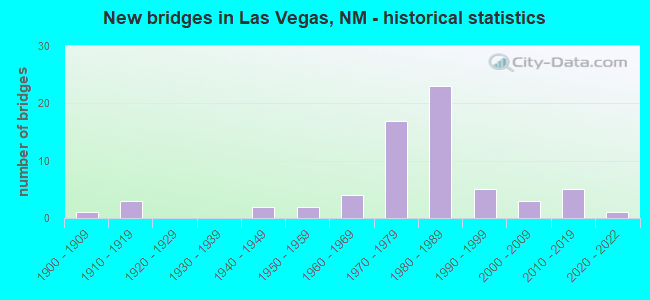
- New bridges - historical statistics
- 11900-1909
- 31910-1919
- 21940-1949
- 21950-1959
- 41960-1969
- 171970-1979
- 231980-1989
- 51990-1999
- 32000-2009
- 52010-2019
- 12020-2022

- Reconstructed bridges - Historical Statistics
- 11950-1959
- 11960-1969
- 21970-1979
- 01980-1989
- 21990-1999
- 22000-2009


- Bridge Condition - Deck
- 43.9%Good
- 41.5%Satisfactory
- 12.2%Fair
- 2.4%Critical

- Bridge Condition - Superstructure
- 4.9%Very good
- 48.8%Good
- 31.7%Satisfactory
- 14.6%Fair

- Bridge Condition - Substructure
- 4.9%Very good
- 43.9%Good
- 24.4%Satisfactory
- 26.8%Fair

- Bridge Condition - Channel
- 13.6%Very good
- 38.6%Good
- 45.5%Satisfactory
- 2.3%Poor

- Bridge Condition - Culverts
- 6.7%Excellent
- 53.3%Good
- 33.3%Satisfactory
- 6.7%Fair
Find on map >> Show street view
Structure Number: 8726, Location: 0.1 MI N OF BERNALILLO ST (Lat: 35.595158, Lng: -105.231550), Route carried "on" structure: City street 47001, Year Built: 1988, Status: Open, Structure Length: 0.67m (2.20ft), Average Daily Traffic: 162 (year 2020), Average Future Daily Traffic: 268 (year 2040), Design Load: HS 20, Features Intersected: LA MANTECA RIVER, Facility Carried by Structure: 47-Z001
Minimum Vertical Clearance: 30+ m (98+ ft), Kilometerpoint: 0.024, Lanes on structure: 2, Owner: County Highway Agency, Approaching Roadway Width: 7.6m (24.9ft), Skew: 1 degrees, Material/Design: Concrete continuous, Design/Construction: Culvert, Number Of Spans In Main Unit: 2, Length of Maximum Span: 3.0m (9.8ft)
Condition: Channel: Satisfactory, Culverts: Good, Operating Rating: 35.6 metric tons, Method Used To Determine Operating Rating: Load Factor (LF), Inventory Rating: 32.4 metric tons, Method Used To Determine Inventory Rating: Load Factor (LF), Structural Evaluation: Better than present minimum criteria, Waterway Adequacy: Equal to present desirable criteria, Approach Roadway Alignment: Equal to present desirable criteria, Designated Inspection Frequency: Every 48 months, Inspection Date: June 2018
Find on map >> Show street view
Structure Number: 8787, Location: 0.2 MI W OF LOOP-15/VEGAS (Lat: 35.588031, Lng: -105.218942), Route carried "on" structure: City street 5562, Year Built: 1991, Status: Open, Structure Length: 4.39m (14.40ft), Average Daily Traffic: 1,722 (year 2018), Truck Traffic: 4%, Average Future Daily Traffic: 2,274 (year 2038), Design Load: HS 20, Features Intersected: GALLINAS RIVER
Minimum Vertical Clearance: 30+ m (98+ ft), Kilometerpoint: 0.425, Lanes on structure: 2, Owner: City or Municipal Highway Agency, Approaching Roadway Width: 10.1m (33.1ft), Material/Design: Concrete continuous, Design/Construction: Slab, Number Of Spans In Main Unit: 4, Length of Maximum Span: 12.2m (40.0ft), Curb or Sidewalk Widths: Left: 1.4m (4.6ft), Right: 0.0m, Curb-To-Curb Width: 10.4m (34.1ft), Out-to-Out Width: 12.6m (41.3ft)
Condition: Deck: Good, Superstructure: Good, Substructure: Good, Channel: Satisfactory, Operating Rating: 28.6 metric tons, Method Used To Determine Operating Rating: Load Factor (LF), Inventory Rating: 17.5 metric tons, Method Used To Determine Inventory Rating: Load Factor (LF), Structural Evaluation: Meets minimum limits, Deck Geometry: Equal to present minimum criteria, Waterway Adequacy: Equal to present desirable criteria, Approach Roadway Alignment: Equal to present desirable criteria, Designated Inspection Frequency: Every 24 months, Inspection Date: December 2020, Deck Structure Type: Concrete Cast-file-Place, Wearing Surface/Protective System: Deck Protection: Epoxy Coated Reinforcing
Find on map >> Show street view
Structure Number: 8937, Location: JCT PECOS ST/NM104 (Lat: 35.595975, Lng: -105.211128), Route carried "on" structure: City street 5662, Year Built: 1997, Status: Open, Structure Length: 1.92m (6.30ft), Average Daily Traffic: 162 (year 2020), Average Future Daily Traffic: 268 (year 2040), Design Load: HS 20, Features Intersected: OPEN FIELD
Minimum Vertical Clearance: 30+ m (98+ ft), Kilometerpoint: 0.161, Lanes on structure: 2, Owner: City or Municipal Highway Agency, Approaching Roadway Width: 10.1m (33.1ft), Material/Design: Steel, Design/Construction: Stringer/Multi-beam, Number Of Spans In Main Unit: 1, Length of Maximum Span: 16.5m (54.1ft), Curb or Sidewalk Widths: Left: 2.0m (6.6ft), Right: 0.0m, Curb-To-Curb Width: 10.1m (33.1ft), Out-to-Out Width: 13.0m (42.7ft)
Condition: Deck: Good, Superstructure: Good, Substructure: Good, Operating Rating: 53.5 metric tons, Method Used To Determine Operating Rating: Load Factor (LF), Inventory Rating: 32.4 metric tons, Method Used To Determine Inventory Rating: Load Factor (LF), Structural Evaluation: Better than present minimum criteria, Deck Geometry: Better than present minimum criteria, Approach Roadway Alignment: Equal to present desirable criteria, Designated Inspection Frequency: Every 24 months, Inspection Date: October 2021, Deck Structure Type: Concrete Cast-file-Place, Wearing Surface/Protective System: Deck Protection: Epoxy Coated Reinforcing
Find on map >> Show street view
Structure Number: 8941, Location: 1.0 M W JCT US 85 & MILLS (Lat: 35.602564, Lng: -105.228397), Route carried "on" structure: City street 4560, Year Built: 1998, Status: Open, Structure Length: 6.19m (20.31ft), Average Daily Traffic: 11,574 (year 2020), Truck Traffic: 2%, Average Future Daily Traffic: 9,384 (year 2040), Design Load: HS 20, Features Intersected: GALLINAS RIVER, Facility Carried by Structure: Mills AVE. (LV)
Minimum Vertical Clearance: 30+ m (98+ ft), Kilometerpoint: 0.644, Lanes on structure: 4, Owner: City or Municipal Highway Agency, Approaching Roadway Width: 39.0m (128.0ft), Skew: 12 degrees, Material/Design: Concrete continuous, Design/Construction: Slab, Number Of Spans In Main Unit: 6, Length of Maximum Span: 11.0m (36.1ft), Curb-To-Curb Width: 19.5m (64.0ft), Out-to-Out Width: 24.1m (79.1ft)
Condition: Deck: Good, Superstructure: Good, Substructure: Good, Channel: Very good, Operating Rating: 53.9 metric tons, Method Used To Determine Operating Rating: Load Factor (LF), Inventory Rating: 32.7 metric tons, Method Used To Determine Inventory Rating: Load Factor (LF), Structural Evaluation: Better than present minimum criteria, Deck Geometry: Better than present minimum criteria, Waterway Adequacy: Equal to present desirable criteria, Approach Roadway Alignment: Equal to present desirable criteria, Designated Inspection Frequency: Every 24 months, Inspection Date: December 2020, Deck Structure Type: Concrete Cast-file-Place
Find on map >> Show street view
Structure Number: 9083, Location: 0.05 MI E OF NEW MEX. AVE (Lat: 35.586844, Lng: -105.226864), Route carried "on" structure: City street 5502, Year Built: 1997, Status: Open, Structure Length: 1.04m (3.41ft), Average Daily Traffic: 162 (year 2020), Average Future Daily Traffic: 268 (year 2040), Design Load: HS 20, Features Intersected: PAJARITO ARROYO
Minimum Vertical Clearance: 30+ m (98+ ft), Kilometerpoint: 0.080, Lanes on structure: 2, Owner: City or Municipal Highway Agency, Approaching Roadway Width: 8.8m (28.9ft), Skew: 4 degrees, Material/Design: Concrete continuous, Design/Construction: Culvert, Number Of Spans In Main Unit: 3, Length of Maximum Span: 2.4m (7.9ft)
Condition: Channel: Good, Culverts: Good, Operating Rating: 37.3 metric tons, Method Used To Determine Operating Rating: Load Factor (LF), Inventory Rating: 32.4 metric tons, Method Used To Determine Inventory Rating: Load Factor (LF), Structural Evaluation: Better than present minimum criteria, Waterway Adequacy: Equal to present desirable criteria, Approach Roadway Alignment: Equal to present minimum criteria, Designated Inspection Frequency: Every 48 months, Inspection Date: November 2019
Find on map >> Show street view
Structure Number: 9177, Location: 6.4 Mi N LOOP-15-/Vegas (Lat: 35.682489, Lng: -105.227444), Route carried "on" structure: State highway 518, Year Built: 2000, Status: Open, Structure Length: 2.80m (9.19ft), Average Daily Traffic: 3,263 (year 2020), Truck Traffic: 21%, Average Future Daily Traffic: 2,804 (year 2040), Design Load: HS 20, Features Intersected: UNNAMED WATERWAY
Minimum Vertical Clearance: 30+ m (98+ ft), Kilometerpoint: 8.750, Lanes on structure: 2, Owner: State Highway Agency, Approaching Roadway Width: 11.0m (36.1ft), Material/Design: Steel, Design/Construction: Culvert, Number Of Spans In Main Unit: 6, Length of Maximum Span: 2.4m (7.9ft)
Condition: Channel: Good, Culverts: Satisfactory, Operating Rating: 45.4 metric tons, Method Used To Determine Operating Rating: Load Factor (LF), Inventory Rating: 32.4 metric tons, Method Used To Determine Inventory Rating: Load Factor (LF), Structural Evaluation: Equal to present minimum criteria, Waterway Adequacy: Equal to present desirable criteria, Approach Roadway Alignment: Equal to present desirable criteria, Designated Inspection Frequency: Every 48 months, Inspection Date: April 2020
Find on map >> Show street view
Structure Number: 9222, Location: STORRIE LAKE PARK (Lat: 35.653561, Lng: -105.240169), Route carried "on" structure: State lands road 47007, Year Built: 2000, Status: Closed, Structure Length: 1.22m (4.00ft), Average Daily Traffic: 162 (year 2020), Average Future Daily Traffic: 268 (year 2040), Design Load: H 15, Features Intersected: GALLINAS CANAL, Facility Carried by Structure: SP-4007
Minimum Vertical Clearance: 30+ m (98+ ft), Kilometerpoint: 0.002, Lanes on structure: 1, Owner: State Agenciy, Approaching Roadway Width: 4.1m (13.5ft), Material/Design: Wood or Timber, Design/Construction: Truss - Thru, Number Of Spans In Main Unit: 1, Length of Maximum Span: 11.6m (38.1ft), Curb-To-Curb Width: 3.4m (11.2ft), Out-to-Out Width: 3.4m (11.2ft)
Condition: Deck: Critical, Superstructure: Good, Substructure: Satisfactory, Channel: Poor, Waterway Adequacy: Equal to present desirable criteria, Approach Roadway Alignment: Equal to present desirable criteria, Bridge Posting: Required (Relationship of Operating Rating to Maximum Legal Load: > 39.9% below), Length Of Structure Improvement: 6.10m (20.01ft), Designated Inspection Frequency: Every 12 months, Critical Feature Inspection Frequency: Every 12 months, Inspection Date: October 2021, Critical Feature Inspection Date: October 2021, Bridge Improvement Cost: $250,000, Roadway Improvement Cost: $150,000, Total Project Cost: $500,000 ( Estimate for 2040), Deck Structure Type: Wood or Timber, Wearing Surface/Protective System: Wearing Surface: Wood or Timber
Find on map >> Show street view
Structure Number: 935, Location: 0.1 M W JCT GRANT AVE (Lat: 35.622231, Lng: -105.207300), Route carried "on" structure: City street 47001, Year Built: 2004, Status: Open, Structure Length: 4.75m (15.58ft), Average Daily Traffic: 162 (year 2020), Average Future Daily Traffic: 268 (year 2040), Design Load: HS 20, Features Intersected: PECOS ARROYO, Facility Carried by Structure: 47-Z001
Minimum Vertical Clearance: 30+ m (98+ ft), Kilometerpoint: 0.805, Lanes on structure: 2, Owner: City or Municipal Highway Agency, Approaching Roadway Width: 13.4m (44.0ft), Skew: 5 degrees, Material/Design: Concrete continuous, Design/Construction: Culvert, Number Of Spans In Main Unit: 3, Length of Maximum Span: 3.7m (12.1ft), Curb or Sidewalk Widths: Left: 0.0m, Right: 1.5m (4.9ft)
Condition: Channel: Good, Culverts: Good, Operating Rating: 71.4 metric tons, Method Used To Determine Operating Rating: Load Factor (LF), Inventory Rating: 32.4 metric tons, Method Used To Determine Inventory Rating: Load Factor (LF), Structural Evaluation: Better than present minimum criteria, Waterway Adequacy: Better than present minimum criteria, Approach Roadway Alignment: Equal to present minimum criteria, Designated Inspection Frequency: Every 48 months, Inspection Date: November 2020
Find on map >> Show street view
Structure Number: 9623, Location: 12.2 M N Jct I-25/US-84 (Lat: 35.677900, Lng: -105.170400), Route carried "on" structure: County highway 250, Year Built: 2014, Status: Open, Structure Length: 5.18m (16.99ft), Average Daily Traffic: 593 (year 2020), Truck Traffic: 16%, Average Future Daily Traffic: 1,109 (year 2040), Design Load: HS 20, Features Intersected: I-25 NBL/SBL
Minimum Vertical Clearance: 30+ m (98+ ft), Kilometerpoint: 4.263, Lanes on structure: 2, Lanes under structure: 4, Owner: State Highway Agency, Approaching Roadway Width: 10.0m (32.8ft), Material/Design: Prestressed concrete, Design/Construction: Box Beam or Girders - Multiple, Number Of Spans In Main Unit: 2, Length of Maximum Span: 25.9m (85.0ft), Curb-To-Curb Width: 10.3m (33.8ft), Out-to-Out Width: 11.0m (36.1ft)
Condition: Deck: Good, Superstructure: Good, Substructure: Good, Operating Rating: 78.0 metric tons, Method Used To Determine Operating Rating: Load Factor (LF), Inventory Rating: 47.2 metric tons, Method Used To Determine Inventory Rating: Load Factor (LF), Structural Evaluation: Better than present minimum criteria, Deck Geometry: Equal to present minimum criteria, Underclear: Equal to present minimum criteria, Approach Roadway Alignment: Somewhat better than minimum adequacy, Designated Inspection Frequency: Every 24 months, Inspection Date: March 2021, Deck Structure Type: Concrete Cast-file-Place, Wearing Surface/Protective System: Wearing Surface: Epoxy Overlay, Membrane: Epoxy, Deck Protection: Epoxy Coated Reinforcing
Find on map >> Show street view
Structure Number: 9651, Location: 13.1 MI N OF JCT NM-104 (Lat: 35.578608, Lng: -104.424856), Route carried "on" structure: State highway 419, Year Built: 2016, Status: Open, Structure Length: 1.94m (6.36ft), Average Daily Traffic: 49 (year 2020), Truck Traffic: 16%, Average Future Daily Traffic: 67 (year 2040), Design Load: HS 20, Features Intersected: ARROYO MESTENO
Minimum Vertical Clearance: 30+ m (98+ ft), Kilometerpoint: 21.024, Lanes on structure: 2, Owner: State Highway Agency, Approaching Roadway Width: 7.6m (24.9ft), Material/Design: Concrete continuous, Design/Construction: Culvert, Number Of Spans In Main Unit: 5, Length of Maximum Span: 3.7m (12.1ft), Curb-To-Curb Width: 9.8m (32.2ft), Out-to-Out Width: 12.8m (42.0ft)
Condition: Channel: Very good, Culverts: Excellent, Operating Rating: 83.3 metric tons, Method Used To Determine Operating Rating: Load Factor (LF), Inventory Rating: 49.9 metric tons, Method Used To Determine Inventory Rating: Load Factor (LF), Structural Evaluation: Superior to present desirable criteria, Deck Geometry: Equal to present desirable criteria, Waterway Adequacy: Superior to present desirable criteria, Approach Roadway Alignment: Equal to present desirable criteria, Designated Inspection Frequency: Every 48 months, Inspection Date: April 2020, Deck Structure Type: Concrete Cast-file-Place, Wearing Surface/Protective System: Wearing Surface: Monolithic Concrete, Deck Protection: Epoxy Coated Reinforcing
Find on map >> Show street view
Structure Number: 9703, Location: 3.4 MI NE OF NM-39 (Lat: 35.823403, Lng: -103.762189), Route carried "on" structure: State highway 102, Year Built: 2020, Status: Open, Structure Length: 7.67m (25.16ft), Average Daily Traffic: 80 (year 2020), Truck Traffic: 16%, Average Future Daily Traffic: 150 (year 2040), Design Load: HL 93, Features Intersected: TEQUESQUITE CREEK
Minimum Vertical Clearance: 30+ m (98+ ft), Kilometerpoint: 5.451, Lanes on structure: 2, Owner: State Highway Agency, Approaching Roadway Width: 8.5m (27.9ft), Material/Design: Concrete, Design/Construction: Stringer/Multi-beam, Number Of Spans In Main Unit: 3, Length of Maximum Span: 25.3m (83.0ft), Curb-To-Curb Width: 8.5m (27.9ft), Out-to-Out Width: 9.8m (32.2ft)
Condition: Deck: Good, Superstructure: Very good, Substructure: Good, Channel: Very good, Operating Rating: 49.0 metric tons, Method Used To Determine Operating Rating: Load Factor (LF), Inventory Rating: 32.7 metric tons, Method Used To Determine Inventory Rating: Load Factor (LF), Structural Evaluation: Better than present minimum criteria, Deck Geometry: Better than present minimum criteria, Waterway Adequacy: Superior to present desirable criteria, Approach Roadway Alignment: Equal to present desirable criteria, Length Of Structure Improvement: 7.68m (25.20ft), Designated Inspection Frequency: Every 24 months, Inspection Date: Febuary 2022, Bridge Improvement Cost: $275,000, Roadway Improvement Cost: $27,000, Total Project Cost: $413,000 ( Estimate for 2030), Deck Structure Type: Concrete Cast-file-Place, Wearing Surface/Protective System: Wearing Surface: Epoxy Overlay, Membrane: Epoxy, Deck Protection: Epoxy Coated Reinforcing
Find on map >> Show street view
Structure Number: 9722, Location: 18.5 MI SE OF JCT NM-419 (Lat: 35.299511, Lng: -104.312014), Route carried "on" structure: State highway 104, Year Built: 2018, Status: Open, Structure Length: 5.18m (16.99ft), Average Daily Traffic: 181 (year 2018), Truck Traffic: 17%, Average Future Daily Traffic: 142 (year 2038), Design Load: HS 20, Features Intersected: LITTLE CUERVO CREEK
Minimum Vertical Clearance: 0.00m, Kilometerpoint: 104.363, Lanes on structure: 2, Owner: State Highway Agency, Approaching Roadway Width: 7.3m (24.0ft), Skew: 2 degrees, Material/Design: Prestressed concrete continuous, Design/Construction: Stringer/Multi-beam, Number Of Spans In Main Unit: 2, Length of Maximum Span: 25.6m (84.0ft), Curb-To-Curb Width: 9.8m (32.2ft), Out-to-Out Width: 10.7m (35.1ft)
Condition: Deck: Good, Superstructure: Good, Substructure: Very good, Channel: Very good, Operating Rating: 53.5 metric tons, Method Used To Determine Operating Rating: Load Factor (LF), Inventory Rating: 32.7 metric tons, Method Used To Determine Inventory Rating: Load Factor (LF), Structural Evaluation: Better than present minimum criteria, Deck Geometry: Better than present minimum criteria, Waterway Adequacy: Superior to present desirable criteria, Approach Roadway Alignment: Equal to present desirable criteria, Designated Inspection Frequency: Every 24 months, Inspection Date: April 2021, Deck Structure Type: Concrete Cast-file-Place
Find on map >> Show street view
Structure Number: 9723, Location: 17.3 MI SE OF JCT NM-419 (Lat: 35.301331, Lng: -104.341919), Route carried "on" structure: State highway 104, Year Built: 2016, Status: Open, Structure Length: 2.87m (9.42ft), Average Daily Traffic: 181 (year 2018), Truck Traffic: 17%, Average Future Daily Traffic: 142 (year 2038), Design Load: HS 20, Features Intersected: PINO CREEK
Minimum Vertical Clearance: 0.00m, Kilometerpoint: 102.016, Lanes on structure: 2, Owner: State Highway Agency, Approaching Roadway Width: 7.3m (24.0ft), Skew: 9 degrees, Material/Design: Prestressed concrete continuous, Design/Construction: Stringer/Multi-beam, Number Of Spans In Main Unit: 2, Length of Maximum Span: 27.7m (90.9ft), Curb-To-Curb Width: 9.8m (32.2ft), Out-to-Out Width: 10.7m (35.1ft)
Condition: Deck: Good, Superstructure: Good, Substructure: Very good, Channel: Very good, Operating Rating: 53.5 metric tons, Method Used To Determine Operating Rating: Load Factor (LF), Inventory Rating: 32.7 metric tons, Method Used To Determine Inventory Rating: Load Factor (LF), Structural Evaluation: Better than present minimum criteria, Deck Geometry: Better than present minimum criteria, Waterway Adequacy: Superior to present desirable criteria, Approach Roadway Alignment: Equal to present desirable criteria, Designated Inspection Frequency: Every 24 months, Inspection Date: April 2021, Deck Structure Type: Concrete Cast-file-Place
Find on map >> Show street view
Structure Number: 7328, Location: 1.7 M S OF S VEGAS INTRCH (Lat: 35.545764, Lng: -105.227408), Route carried "under" structure: Interstate 25, Year Built: 1973, Structure Length: 0. m, Average Daily Traffic: 10,521 (year 2020), Truck Traffic: 37%, Features Intersected: I-25 NBLS/SBLS, Facility Carried by Structure: FR-2138
Minimum Vertical Clearance: 4.90m (16.08ft), Kilometerpoint: 550.850, Lanes on structure: 2, Lanes under structure: 4, Material/Design: Prestressed concrete, Design/Construction: Stringer/Multi-beam, Length of Maximum Span: 25.9m (85.0ft)
Find on map >> Show street view
Structure Number: 7331, Location: 0.9 M S OF S VEGAS INTRCH (Lat: 35.557100, Lng: -105.224908), Route carried "under" structure: Interstate 25, Year Built: 1973, Structure Length: 0. m, Average Daily Traffic: 10,521 (year 2020), Truck Traffic: 37%, Features Intersected: I-25 NBL/SBL, Facility Carried by Structure: NM-283
Minimum Vertical Clearance: 4.90m (16.08ft), Kilometerpoint: 552.166, Lanes on structure: 2, Lanes under structure: 4, Material/Design: Prestressed concrete, Design/Construction: Stringer/Multi-beam, Length of Maximum Span: 25.9m (85.0ft)
Find on map >> Show street view
Structure Number: 7332, Location: SOUTH LAS VEGAS INTERCHNG (Lat: 35.568839, Lng: -105.220303), Route carried "under" structure: State highway 15, Year Built: 1973, Structure Length: 0. m, Average Daily Traffic: 3,127 (year 2020), Truck Traffic: 7%, Features Intersected: LOOP-15/LAS VEGAS, Facility Carried by Structure: I-25 NBL
Minimum Vertical Clearance: 5.36m (17.59ft), Kilometerpoint: 0.233, Lanes on structure: 2, Lanes under structure: 4, Material/Design: Prestressed concrete, Design/Construction: Stringer/Multi-beam, Length of Maximum Span: 30.2m (99.1ft)
Find on map >> Show street view
Structure Number: 7333, Location: SOUTH LAS VEGAS INTERCHNG (Lat: 35.569044, Lng: -105.220497), Route carried "under" structure: State highway 15, Year Built: 1973, Structure Length: 0. m, Average Daily Traffic: 3,127 (year 2020), Truck Traffic: 7%, Features Intersected: LOOP-15/LAS VEGAS, Facility Carried by Structure: I-25 SBL
Minimum Vertical Clearance: 5.00m (16.40ft), Kilometerpoint: 0.249, Lanes on structure: 2, Lanes under structure: 4, Material/Design: Prestressed concrete, Design/Construction: Stringer/Multi-beam, Length of Maximum Span: 30.2m (99.1ft)
Find on map >> Show street view
Structure Number: 7893, Location: 0.2 MI E OF LOOP-15 (Lat: 35.596003, Lng: -105.210433), Route carried "under" structure: Interstate 25, Year Built: 1982, Structure Length: 0. m, Average Daily Traffic: 6,559 (year 2020), Truck Traffic: 51%, Features Intersected: I-25/R/R/CITY ST/WATERWY, Facility Carried by Structure: NM-104
Minimum Vertical Clearance: 9.45m (31.00ft), Kilometerpoint: 556.869, Lanes on structure: 4, Lanes under structure: 4, Material/Design: Steel continuous, Design/Construction: Stringer/Multi-beam, Length of Maximum Span: 31.1m (102.0ft)
Find on map >> Show street view
Structure Number: 8239, Location: 1.4 MI S OF JCT NM-104 (Lat: 35.575678, Lng: -105.212142), Route carried "under" structure: County highway 47023, Year Built: 1982, Structure Length: 0. m, Average Daily Traffic: 203 (year 2020), Truck Traffic: 6%, Features Intersected: COUNTY RD-21, Facility Carried by Structure: I-25 NBL
Minimum Vertical Clearance: 5.69m (18.67ft), Kilometerpoint: 0.761, Lanes on structure: 2, Lanes under structure: 2, Material/Design: Prestressed concrete continuous, Design/Construction: Stringer/Multi-beam, Length of Maximum Span: 17.1m (56.1ft)
Find on map >> Show street view
Structure Number: 824, Location: 1.4 MI S OF JCT NM-104 (Lat: 35.575722, Lng: -105.212450), Route carried "under" structure: County highway 47023, Year Built: 1982, Structure Length: 0. m, Average Daily Traffic: 203 (year 2020), Truck Traffic: 6%, Features Intersected: COUNTY RD-21, Facility Carried by Structure: I-25 SBL
Minimum Vertical Clearance: 4.95m (16.24ft), Kilometerpoint: 0.745, Lanes on structure: 2, Lanes under structure: 2, Material/Design: Prestressed concrete continuous, Design/Construction: Stringer/Multi-beam, Length of Maximum Span: 17.1m (56.1ft)
Find on map >> Show street view
Structure Number: 8251, Location: 2.0 MI N OF JCT NM-104 (Lat: 35.624650, Lng: -105.203292), Route carried "under" structure: State highway 15, Year Built: 1982, Structure Length: 0. m, Average Daily Traffic: 1,993 (year 2020), Truck Traffic: 7%, Features Intersected: LOOP-15, Facility Carried by Structure: I-25 NBL
Minimum Vertical Clearance: 5.44m (17.85ft), Kilometerpoint: 6.687, Lanes on structure: 2, Lanes under structure: 4, Material/Design: Steel continuous, Design/Construction: Stringer/Multi-beam, Length of Maximum Span: 35.1m (115.2ft)
Find on map >> Show street view
Structure Number: 8252, Location: 2.0 MI N OF JCT NM-104 (Lat: 35.624500, Lng: -105.203600), Route carried "under" structure: State highway 15, Year Built: 1982, Structure Length: 0. m, Average Daily Traffic: 4,115 (year 2020), Truck Traffic: 7%, Features Intersected: LOOP-15, Facility Carried by Structure: I-25 SBL
Minimum Vertical Clearance: 5.49m (18.01ft), Kilometerpoint: 6.671, Lanes on structure: 2, Lanes under structure: 4, Material/Design: Steel continuous, Design/Construction: Stringer/Multi-beam, Length of Maximum Span: 35.1m (115.2ft)
Find on map >> Show street view
Structure Number: 9623, Location: 12.2 M N Jct I-25/US-84 (Lat: 35.677900, Lng: -105.170400), Route carried "under" structure: Interstate 25, Year Built: 2014, Structure Length: 0. m, Average Daily Traffic: 5,858 (year 2020), Truck Traffic: 37%, Features Intersected: I-25 NBL/SBL
Minimum Vertical Clearance: 5.09m (16.70ft), Kilometerpoint: 566.811, Lanes on structure: 2, Lanes under structure: 4, Material/Design: Prestressed concrete, Design/Construction: Box Beam or Girders - Multiple, Length of Maximum Span: 25.9m (85.0ft)