Bridge Statistics for Lawrenceville, Georgia (GA)
Condition, Traffic, Stress, Structural Evaluation, Project Costs
- National Bridge Inventory (NBI) Statistics
- 72Number of bridges
- 863ft / 263mTotal length
- $302,444,000Total costs
- 1,849,720Total average daily traffic
- 25,690Total average daily truck traffic
- National Bridge Inventory (NBI) Registered Bridges for Lawrenceville
- No street view available for this location
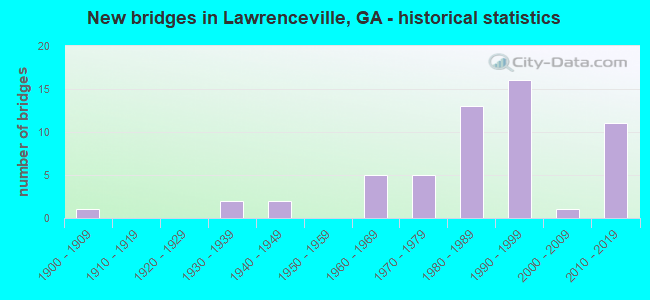
- New bridges - historical statistics
- 11900-1909
- 21930-1939
- 21940-1949
- 51960-1969
- 51970-1979
- 131980-1989
- 161990-1999
- 12000-2009
- 112010-2019

- Reconstructed bridges - Historical Statistics
- 21970-1979
- 41980-1989
- 21990-1999


- Bridge Condition - Deck
- 15.8%Very good
- 76.3%Good
- 7.9%Satisfactory

- Bridge Condition - Superstructure
- 68.4%Very good
- 26.3%Good
- 5.3%Satisfactory

- Bridge Condition - Substructure
- 21.1%Very good
- 68.4%Good
- 10.5%Satisfactory

- Bridge Condition - Channel
- 2.7%Excellent
- 40.5%Very good
- 32.4%Good
- 8.1%Satisfactory
- 16.2%Fair

- Bridge Condition - Culverts
- 88.9%Good
- 11.1%Satisfactory
Find on map >> Show street view
Structure Number: 1355185, Location: 1.4 MI W OF LAWRENCEVILLE (Lat: 33.951828, Lng: -84.015019), Route carried "on" structure: City street 9466, Year Built: 1999, Status: Open, Structure Length: 1.19m (3.90ft), Average Daily Traffic: 7,890 (year 2012), Truck Traffic: 1%, Average Future Daily Traffic: 11,835 (year 2032), Design Load: HS 20+Mod, Features Intersected: REDLAND CREEK, Facility Carried by Structure: L-VILLE-SUWANEE RD
Minimum Vertical Clearance: 30+ m (98+ ft), Kilometerpoint: 3.219, Lanes on structure: 4, Base Highway Network: Yes, Owner: County Highway Agency, Approaching Roadway Width: 21.9m (71.9ft), Skew: 13 degrees, Material/Design: Concrete, Design/Construction: Culvert, Number Of Spans In Main Unit: 3, Length of Maximum Span: 3.7m (12.1ft)
Condition: Channel: Good, Culverts: Good, Structural Evaluation: Better than present minimum criteria, Waterway Adequacy: Equal to present desirable criteria, Approach Roadway Alignment: Equal to present desirable criteria, Designated Inspection Frequency: Every 24 months, Inspection Date: October 2021, Bridge Improvement Cost: $235,000, Roadway Improvement Cost: $24,000, Total Project Cost: $353,000
Find on map >> Show street view
Structure Number: 1355189, Location: 4.6 MI W OF LAWRENCIVILLE (Lat: 33.966736, Lng: -84.068142), Route carried "on" structure: City street 6512, Year Built: 1999, Status: Open, Structure Length: 1.34m (4.40ft), Average Daily Traffic: 32,720 (year 2012), Truck Traffic: 1%, Average Future Daily Traffic: 49,080 (year 2032), Design Load: HS 20+Mod, Features Intersected: FORK CREEK TRIB, Facility Carried by Structure: SUGARLOAF PARKWAY
Minimum Vertical Clearance: 30+ m (98+ ft), Kilometerpoint: 8.047, Lanes on structure: 4, Base Highway Network: Yes, Owner: County Highway Agency, Approaching Roadway Width: 19.5m (64.0ft), Skew: 24 degrees, Material/Design: Concrete, Design/Construction: Culvert, Number Of Spans In Main Unit: 3, Length of Maximum Span: 4.3m (14.1ft)
Condition: Channel: Very good, Culverts: Good, Operating Rating: 55.3 metric tons, Method Used To Determine Operating Rating: Field evaluation and documented engineering judgment, Inventory Rating: 32.6 metric tons, Method Used To Determine Inventory Rating: Field evaluation and documented engineering judgment, Structural Evaluation: Better than present minimum criteria, Waterway Adequacy: Equal to present desirable criteria, Approach Roadway Alignment: Equal to present desirable criteria, Designated Inspection Frequency: Every 24 months, Inspection Date: October 2021, Bridge Improvement Cost: $266,000, Roadway Improvement Cost: $27,000, Total Project Cost: $399,000
Find on map >> Show street view
Structure Number: 1355226, Location: 5.2 MI W OF LAWRENCEVILLE (Lat: 33.954944, Lng: -84.082178), Route carried "on" structure: County highway 544, Year Built: 2009, Status: Open, Structure Length: 5.33m (17.49ft), Average Daily Traffic: 1,930 (year 2012), Truck Traffic: 1%, Average Future Daily Traffic: 2,895 (year 2032), Design Load: HS 20+Mod, Features Intersected: FORK CREEK TRIB, Facility Carried by Structure: HERRINGTON ROAD
Minimum Vertical Clearance: 30+ m (98+ ft), Kilometerpoint: 1.609, Lanes on structure: 2, Base Highway Network: Yes, Owner: County Highway Agency, Approaching Roadway Width: 12.8m (42.0ft), Skew: 1 degrees, Material/Design: Prestressed concrete, Design/Construction: Stringer/Multi-beam, Number Of Spans In Main Unit: 3, Length of Maximum Span: 18.3m (60.0ft), Curb or Sidewalk Widths: Left: 3.0m (9.8ft), Right: 3.0m (9.8ft), Curb-To-Curb Width: 12.8m (42.0ft), Out-to-Out Width: 19.7m (64.6ft)
Condition: Deck: Good, Superstructure: Very good, Substructure: Good, Channel: Good, Operating Rating: 32.6 metric tons, Method Used To Determine Operating Rating: Allowable Stress (AS), Inventory Rating: 20.8 metric tons, Method Used To Determine Inventory Rating: Allowable Stress (AS), Structural Evaluation: Somewhat better than minimum adequacy, Deck Geometry: Better than present minimum criteria, Waterway Adequacy: Better than present minimum criteria, Approach Roadway Alignment: Equal to present minimum criteria, Length Of Structure Improvement: 41.79m (137.11ft), Designated Inspection Frequency: Every 24 months, Inspection Date: September 2021, Bridge Improvement Cost: $684,000, Roadway Improvement Cost: $68,000, Total Project Cost: $1,026,000, Deck Structure Type: Concrete Cast-file-Place
Find on map >> Show street view
Structure Number: 1355228, Location: 3.5 MI SW OF LAWRENCEVILL (Lat: 33.925847, Lng: -84.037928), Route carried "on" structure: County highway 461, Year Built: 2011, Status: Open, Structure Length: 3.75m (12.30ft), Average Daily Traffic: 1,930 (year 2012), Truck Traffic: 1%, Average Future Daily Traffic: 2,895 (year 2032), Design Load: HS 20+Mod, Features Intersected: PEW CREEK, Facility Carried by Structure: PATTERSON ROAD
Minimum Vertical Clearance: 30+ m (98+ ft), Kilometerpoint: 1.609, Lanes on structure: 2, Base Highway Network: Yes, Owner: County Highway Agency, Approaching Roadway Width: 10.4m (34.1ft), Skew: 1 degrees, Material/Design: Concrete, Design/Construction: Stringer/Multi-beam, Number Of Spans In Main Unit: 2, Length of Maximum Span: 26.8m (87.9ft), Curb or Sidewalk Widths: Left: 1.8m (5.9ft), Right: 1.8m (5.9ft), Curb-To-Curb Width: 11.3m (37.1ft), Out-to-Out Width: 15.6m (51.2ft)
Condition: Deck: Good, Superstructure: Very good, Substructure: Very good, Channel: Very good, Operating Rating: 67.1 metric tons, Method Used To Determine Operating Rating: Load Factor (LF), Inventory Rating: 34.4 metric tons, Method Used To Determine Inventory Rating: Load Factor (LF), Structural Evaluation: Equal to present desirable criteria, Deck Geometry: Equal to present minimum criteria, Waterway Adequacy: Better than present minimum criteria, Approach Roadway Alignment: Somewhat better than minimum adequacy, Designated Inspection Frequency: Every 24 months, Inspection Date: October 2021, Bridge Improvement Cost: $481,000, Roadway Improvement Cost: $48,000, Total Project Cost: $721,000, Deck Structure Type: Concrete Cast-file-Place
Find on map >> Show street view
Structure Number: 1355232, Location: LAWRENCEVILLE (Lat: 33.927036, Lng: -83.952500), Route carried "on" structure: County highway 6512, Year Built: 2010, Status: Open, Structure Length: 2.29m (7.51ft), Average Daily Traffic: 4,330 (year 2012), Truck Traffic: 1%, Average Future Daily Traffic: 6,495 (year 2032), Design Load: HS 20+Mod, Features Intersected: CHANDLER ROAD, Facility Carried by Structure: SUGARLOAF PKY (NBL
Minimum Vertical Clearance: 30+ m (98+ ft), Kilometerpoint: 6.437, Lanes on structure: 2, Lanes under structure: 2, Base Highway Network: Yes, Owner: County Highway Agency, Approaching Roadway Width: 10.7m (35.1ft), Skew: 10 degrees, Material/Design: Prestressed concrete, Design/Construction: Stringer/Multi-beam, Number Of Spans In Main Unit: 1, Length of Maximum Span: 22.9m (75.1ft), Curb-To-Curb Width: 12.2m (40.0ft), Out-to-Out Width: 13.3m (43.6ft)
Condition: Deck: Good, Superstructure: Very good, Substructure: Very good, Operating Rating: 75.2 metric tons, Method Used To Determine Operating Rating: Load Factor (LF), Inventory Rating: 37.1 metric tons, Method Used To Determine Inventory Rating: Load Factor (LF), Structural Evaluation: Equal to present desirable criteria, Deck Geometry: Better than present minimum criteria, Underclear: Somewhat better than minimum adequacy, Approach Roadway Alignment: Equal to present desirable criteria, Designated Inspection Frequency: Every 24 months, Inspection Date: Febuary 2022, Bridge Improvement Cost: $293,000, Roadway Improvement Cost: $29,000, Total Project Cost: $440,000, Deck Structure Type: Concrete Cast-file-Place
Find on map >> Show street view
Structure Number: 1355233, Location: LAWRENCEVILLE (Lat: 33.926878, Lng: -83.952353), Route carried "on" structure: County highway 6512, Year Built: 2010, Status: Open, Structure Length: 2.29m (7.51ft), Average Daily Traffic: 4,330 (year 2012), Truck Traffic: 1%, Average Future Daily Traffic: 6,495 (year 2032), Design Load: HS 20+Mod, Features Intersected: CHANDLER ROAD, Facility Carried by Structure: SUGARLOAF PKY (SBL
Minimum Vertical Clearance: 30+ m (98+ ft), Kilometerpoint: 6.437, Lanes on structure: 2, Lanes under structure: 2, Base Highway Network: Yes, Owner: County Highway Agency, Approaching Roadway Width: 10.7m (35.1ft), Skew: 10 degrees, Material/Design: Prestressed concrete, Design/Construction: Stringer/Multi-beam, Number Of Spans In Main Unit: 1, Length of Maximum Span: 22.9m (75.1ft), Curb-To-Curb Width: 12.2m (40.0ft), Out-to-Out Width: 13.3m (43.6ft)
Condition: Deck: Good, Superstructure: Very good, Substructure: Very good, Operating Rating: 75.2 metric tons, Method Used To Determine Operating Rating: Load Factor (LF), Inventory Rating: 37.1 metric tons, Method Used To Determine Inventory Rating: Load Factor (LF), Structural Evaluation: Equal to present desirable criteria, Deck Geometry: Better than present minimum criteria, Underclear: Somewhat better than minimum adequacy, Approach Roadway Alignment: Equal to present desirable criteria, Designated Inspection Frequency: Every 24 months, Inspection Date: Febuary 2022, Bridge Improvement Cost: $293,000, Roadway Improvement Cost: $29,000, Total Project Cost: $440,000, Deck Structure Type: Concrete Cast-file-Place
Find on map >> Show street view
Structure Number: 1355234, Location: LAWRENCEVILLE (Lat: 33.935231, Lng: -83.933492), Route carried "on" structure: County highway 99998, Year Built: 2010, Status: Open, Structure Length: 6.22m (20.41ft), Average Daily Traffic: 1,930 (year 2012), Truck Traffic: 1%, Average Future Daily Traffic: 2,895 (year 2032), Design Load: HS 20+Mod, Features Intersected: SUGARLOAF PKY, Facility Carried by Structure: HIRAM DAVIS ROAD
Minimum Vertical Clearance: 30+ m (98+ ft), Kilometerpoint: 1.609, Lanes on structure: 2, Lanes under structure: 5, Owner: County Highway Agency, Approaching Roadway Width: 8.2m (26.9ft), Skew: 2 degrees, Material/Design: Prestressed concrete, Design/Construction: Stringer/Multi-beam, Number Of Spans In Main Unit: 2, Length of Maximum Span: 34.7m (113.8ft), Curb-To-Curb Width: 13.4m (44.0ft), Out-to-Out Width: 14.5m (47.6ft)
Condition: Deck: Very good, Superstructure: Very good, Substructure: Good, Operating Rating: 62.5 metric tons, Method Used To Determine Operating Rating: Load Factor (LF), Inventory Rating: 38.1 metric tons, Method Used To Determine Inventory Rating: Load Factor (LF), Structural Evaluation: Better than present minimum criteria, Deck Geometry: Equal to present desirable criteria, Underclear: Equal to present minimum criteria, Approach Roadway Alignment: Equal to present desirable criteria, Designated Inspection Frequency: Every 24 months, Inspection Date: Febuary 2022, Bridge Improvement Cost: $797,000, Roadway Improvement Cost: $80,000, Total Project Cost: $1,196,000, Deck Structure Type: Concrete Cast-file-Place
Find on map >> Show street view
Structure Number: 1355235, Location: LAWRENCEVILLE (Lat: 33.932094, Lng: -83.940761), Route carried "on" structure: County highway 99999, Year Built: 2010, Status: Open, Structure Length: 4.94m (16.21ft), Average Daily Traffic: 8,640 (year 2012), Truck Traffic: 1%, Average Future Daily Traffic: 12,960 (year 2032), Design Load: HS 20+Mod, Features Intersected: SUGARLOAF PKY, Facility Carried by Structure: NEW HOPE ROAD
Minimum Vertical Clearance: 30+ m (98+ ft), Kilometerpoint: 4.828, Lanes on structure: 6, Lanes under structure: 4, Owner: County Highway Agency, Approaching Roadway Width: 24.1m (79.1ft), Material/Design: Prestressed concrete, Design/Construction: Stringer/Multi-beam, Number Of Spans In Main Unit: 2, Length of Maximum Span: 24.7m (81.0ft), Curb-To-Curb Width: 40.8m (133.9ft), Out-to-Out Width: 41.9m (137.5ft)
Condition: Deck: Very good, Superstructure: Very good, Substructure: Very good, Operating Rating: 58.0 metric tons, Method Used To Determine Operating Rating: Load Factor (LF), Inventory Rating: 34.4 metric tons, Method Used To Determine Inventory Rating: Load Factor (LF), Structural Evaluation: Equal to present desirable criteria, Deck Geometry: Superior to present desirable criteria, Underclear: Better than present minimum criteria, Approach Roadway Alignment: Equal to present desirable criteria, Designated Inspection Frequency: Every 24 months, Inspection Date: Febuary 2022, Bridge Improvement Cost: $1,323,000, Roadway Improvement Cost: $132,000, Total Project Cost: $1,985,000, Deck Structure Type: Concrete Cast-file-Place
Find on map >> Show street view
Structure Number: 135525, Location: AT FORSYTH COUNTY LINE (Lat: 34.126017, Lng: -84.093417), Route carried "on" structure: State highway 20, Year Built: 2015, Status: Open, Structure Length: 14.17m (46.49ft), Average Daily Traffic: 28,840 (year 2012), Truck Traffic: 7%, Average Future Daily Traffic: 43,260 (year 2032), Design Load: HS 20+Mod, Features Intersected: CHATTAHOOCHEE RIVER
Minimum Vertical Clearance: 30+ m (98+ ft), Kilometerpoint: 0.000, Lanes on structure: 2, Base Highway Network: Yes, Owner: State Highway Agency, Approaching Roadway Width: 7.3m (24.0ft), Skew: 5 degrees, Material/Design: Concrete, Design/Construction: Stringer/Multi-beam, Number Of Spans In Main Unit: 4, Length of Maximum Span: 42.7m (140.1ft), Curb or Sidewalk Widths: Left: 0.6m (2.0ft), Right: 1.8m (5.9ft), Curb-To-Curb Width: 11.0m (36.1ft), Out-to-Out Width: 13.7m (44.9ft)
Condition: Deck: Good, Superstructure: Good, Substructure: Good, Channel: Very good, Operating Rating: 70.7 metric tons, Method Used To Determine Operating Rating: Load Factor (LF), Inventory Rating: 35.3 metric tons, Method Used To Determine Inventory Rating: Load Factor (LF), Structural Evaluation: Better than present minimum criteria, Deck Geometry: Equal to present minimum criteria, Waterway Adequacy: Superior to present desirable criteria, Approach Roadway Alignment: Equal to present desirable criteria, Length Of Structure Improvement: 17.01m (55.81ft), Designated Inspection Frequency: Every 24 months, Underwater Inspection Frequency: Every 60 months, Inspection Date: November 2021, Underwater Inspection Date: April 2019, Bridge Improvement Cost: $41,292,000, Roadway Improvement Cost: $4,129,000, Total Project Cost: $61,938,000 ( Estimate for 2016), Deck Structure Type: Concrete Cast-file-Place
Find on map >> Show street view
Structure Number: 1355251, Location: 1.5 MI N OF LAWRENCEVILLE (Lat: 33.975817, Lng: -84.002486), Route carried "on" structure: State highway 316, Year Built: 2015, Status: Open, Structure Length: 3.14m (10.30ft), Average Daily Traffic: 60,490 (year 2012), Truck Traffic: 1%, Average Future Daily Traffic: 90,735 (year 2032), Design Load: HS 20+Mod, Features Intersected: YELLOW RIV TRIB-COL PIPE
Minimum Vertical Clearance: 30+ m (98+ ft), Kilometerpoint: 9.656, Lanes on structure: 3, Base Highway Network: Yes, Owner: State Highway Agency, Approaching Roadway Width: 14.6m (47.9ft), Skew: 16 degrees, Material/Design: Prestressed concrete, Design/Construction: Stringer/Multi-beam, Number Of Spans In Main Unit: 1, Length of Maximum Span: 31.4m (103.0ft), Curb-To-Curb Width: 27.7m (90.9ft), Out-to-Out Width: 28.6m (93.8ft)
Condition: Deck: Good, Superstructure: Very good, Substructure: Very good, Channel: Excellent, Operating Rating: 88.9 metric tons, Method Used To Determine Operating Rating: Load Factor (LF), Inventory Rating: 37.1 metric tons, Method Used To Determine Inventory Rating: Load Factor (LF), Structural Evaluation: Equal to present desirable criteria, Deck Geometry: Superior to present desirable criteria, Waterway Adequacy: Equal to present desirable criteria, Approach Roadway Alignment: Better than present minimum criteria, Length Of Structure Improvement: 3.78m (12.40ft), Designated Inspection Frequency: Every 24 months, Inspection Date: Febuary 2022, Bridge Improvement Cost: $9,176,000, Roadway Improvement Cost: $918,000, Total Project Cost: $13,764,000 ( Estimate for 2016), Deck Structure Type: Concrete Cast-file-Place
Find on map >> Show street view
Structure Number: 1355254, Location: 1.5 MI N OF LAWRENCEVILLE (Lat: 33.976031, Lng: -84.002797), Route carried "on" structure: State highway 316, Year Built: 2015, Status: Open, Structure Length: 5.61m (18.41ft), Average Daily Traffic: 60,490 (year 2012), Truck Traffic: 1%, Average Future Daily Traffic: 90,735 (year 2032), Design Load: HS 20+Mod, Features Intersected: YELLOW RIV TRIB-COL PIPE
Minimum Vertical Clearance: 30+ m (98+ ft), Kilometerpoint: 9.656, Lanes on structure: 3, Base Highway Network: Yes, Owner: State Highway Agency, Approaching Roadway Width: 14.6m (47.9ft), Skew: 16 degrees, Material/Design: Prestressed concrete, Design/Construction: Stringer/Multi-beam, Number Of Spans In Main Unit: 1, Length of Maximum Span: 56.1m (184.1ft), Curb-To-Curb Width: 27.7m (90.9ft), Out-to-Out Width: 28.6m (93.8ft)
Condition: Deck: Good, Superstructure: Good, Substructure: Very good, Channel: Very good, Operating Rating: 55.3 metric tons, Method Used To Determine Operating Rating: Field evaluation and documented engineering judgment, Inventory Rating: 32.6 metric tons, Method Used To Determine Inventory Rating: Field evaluation and documented engineering judgment, Structural Evaluation: Better than present minimum criteria, Deck Geometry: Superior to present desirable criteria, Waterway Adequacy: Equal to present desirable criteria, Approach Roadway Alignment: Better than present minimum criteria, Length Of Structure Improvement: 6.71m (22.01ft), Designated Inspection Frequency: Every 24 months, Inspection Date: Febuary 2022, Bridge Improvement Cost: $16,280,000, Roadway Improvement Cost: $1,628,000, Total Project Cost: $24,420,000 ( Estimate for 2017), Deck Structure Type: Concrete Cast-file-Place
Find on map >> Show street view
Structure Number: 1355258, Location: IN LAWRENCEVILLE (Lat: 33.979258, Lng: -83.985419), Route carried "on" structure: State highway 20, Year Built: 2016, Status: Open, Structure Length: 10.93m (35.86ft), Average Daily Traffic: 25,730 (year 2012), Truck Traffic: 1%, Average Future Daily Traffic: 38,595 (year 2032), Design Load: HS 20+Mod, Features Intersected: HWY 316
Minimum Vertical Clearance: 30+ m (98+ ft), Kilometerpoint: 24.140, Lanes on structure: 8, Lanes under structure: 4, Base Highway Network: Yes, Owner: State Highway Agency, Approaching Roadway Width: 37.8m (124.0ft), Material/Design: Prestressed concrete, Design/Construction: Stringer/Multi-beam, Number Of Spans In Main Unit: 4, Length of Maximum Span: 32.0m (105.0ft), Curb or Sidewalk Widths: Left: 1.8m (5.9ft), Right: 1.8m (5.9ft), Curb-To-Curb Width: 37.8m (124.0ft), Out-to-Out Width: 42.2m (138.5ft)
Condition: Deck: Good, Superstructure: Very good, Substructure: Good, Operating Rating: 48.9 metric tons, Method Used To Determine Operating Rating: Load Factor (LF), Inventory Rating: 29.0 metric tons, Method Used To Determine Inventory Rating: Load Factor (LF), Structural Evaluation: Better than present minimum criteria, Deck Geometry: Superior to present desirable criteria, Underclear: Superior to present desirable criteria, Approach Roadway Alignment: Equal to present desirable criteria, Length Of Structure Improvement: 13.11m (43.01ft), Designated Inspection Frequency: Every 24 months, Inspection Date: Febuary 2022, Bridge Improvement Cost: $31,820,000, Roadway Improvement Cost: $3,182,000, Total Project Cost: $47,730,000 ( Estimate for 2018), Deck Structure Type: Concrete Cast-file-Place
Find on map >> Show street view
Structure Number: 1355259, Location: .5 MI W OF LAWRENCEVILLE (Lat: 33.977244, Lng: -83.996039), Route carried "on" structure: County highway 104, Year Built: 2016, Status: Open, Structure Length: 11.03m (36.19ft), Average Daily Traffic: 9,790 (year 2012), Truck Traffic: 1%, Average Future Daily Traffic: 14,685 (year 2032), Design Load: HS 20+Mod, Features Intersected: SR 316, Facility Carried by Structure: COLLINS HILL RD
Minimum Vertical Clearance: 30+ m (98+ ft), Kilometerpoint: 4.828, Lanes on structure: 4, Lanes under structure: 9, Owner: State Highway Agency, Approaching Roadway Width: 24.4m (80.1ft), Skew: 13 degrees, Material/Design: Prestressed concrete, Design/Construction: Stringer/Multi-beam, Number Of Spans In Main Unit: 4, Length of Maximum Span: 31.7m (104.0ft), Curb or Sidewalk Widths: Left: 1.8m (5.9ft), Right: 1.8m (5.9ft), Curb-To-Curb Width: 24.4m (80.1ft), Out-to-Out Width: 28.8m (94.5ft)
Condition: Deck: Good, Superstructure: Very good, Substructure: Good, Operating Rating: 55.3 metric tons, Method Used To Determine Operating Rating: Load Factor (LF), Inventory Rating: 32.6 metric tons, Method Used To Determine Inventory Rating: Load Factor (LF), Structural Evaluation: Better than present minimum criteria, Deck Geometry: Superior to present desirable criteria, Underclear: Meets minimum limits, Approach Roadway Alignment: Equal to present minimum criteria, Length Of Structure Improvement: 13.23m (43.41ft), Designated Inspection Frequency: Every 24 months, Inspection Date: Febuary 2022, Bridge Improvement Cost: $31,116,000, Roadway Improvement Cost: $3,212,000, Total Project Cost: $48,174,000 ( Estimate for 2018), Deck Structure Type: Concrete Cast-file-Place
Find on map >> Show street view
Structure Number: 135526, Location: .5 MI W OF LAWRENCEVILLE (Lat: 33.972281, Lng: -84.008256), Route carried "on" structure: County highway 3931, Year Built: 2017, Status: Open, Structure Length: 11.25m (36.91ft), Average Daily Traffic: 6,800 (year 2017), Truck Traffic: 1%, Average Future Daily Traffic: 8,400 (year 2036), Design Load: HS 20+Mod, Features Intersected: SR 316, Facility Carried by Structure: WALTHER BLVD
Minimum Vertical Clearance: 30+ m (98+ ft), Kilometerpoint: 3.219, Lanes on structure: 4, Lanes under structure: 4, Owner: State Highway Agency, Approaching Roadway Width: 14.6m (47.9ft), Skew: 3 degrees, Material/Design: Prestressed concrete, Design/Construction: Stringer/Multi-beam, Number Of Spans In Main Unit: 4, Length of Maximum Span: 39.6m (129.9ft), Curb or Sidewalk Widths: Left: 1.8m (5.9ft), Right: 1.8m (5.9ft), Curb-To-Curb Width: 15.2m (49.9ft), Out-to-Out Width: 19.7m (64.6ft)
Condition: Deck: Very good, Superstructure: Very good, Substructure: Good, Operating Rating: 68.0 metric tons, Method Used To Determine Operating Rating: Load Factor (LF), Inventory Rating: 37.1 metric tons, Method Used To Determine Inventory Rating: Load Factor (LF), Structural Evaluation: Better than present minimum criteria, Deck Geometry: High priority of corrective action, Underclear: Superior to present desirable criteria, Approach Roadway Alignment: Equal to present minimum criteria, Length Of Structure Improvement: 13.50m (44.29ft), Designated Inspection Frequency: Every 24 months, Inspection Date: Febuary 2022, Bridge Improvement Cost: $32,782,000, Roadway Improvement Cost: $3,278,000, Total Project Cost: $49,173,000 ( Estimate for 2018), Deck Structure Type: Concrete Cast-file-Place
Find on map >> Show street view
Structure Number: 1350027, Location: .5 MI W OF LAWRENCEVILLE (Lat: 33.967200, Lng: -84.016503), Route carried "under" structure: State highway 316, Structure Length: 0. m, Average Daily Traffic: 53,600 (year 1998), Truck Traffic: 1%, Features Intersected: SR 120, Facility Carried by Structure: SR 120
Minimum Vertical Clearance: 5.23m (17.16ft), Kilometerpoint: 8.047, Lanes on structure: 5, Length of Maximum Span: 0.0m
Find on map >> Show street view
Structure Number: 135006, Location: 3.8 MI SE OF DULUTH (Lat: 33.962608, Lng: -84.079478), Route carried "under" structure: State highway 316, Structure Length: 0. m, Average Daily Traffic: 86,400 (year 1998), Truck Traffic: 1%, Features Intersected: CR 544 HERRINGTON ROAD, Facility Carried by Structure: HERRINGTON ROAD
Minimum Vertical Clearance: 5.38m (17.65ft), Kilometerpoint: 1.609, Lanes on structure: 2, Length of Maximum Span: 0.0m
Find on map >> Show street view
Structure Number: 1350115, Location: IN LAWRENCEVILLE (Lat: 33.956272, Lng: -83.994017), Route carried "under" structure: State highway 120, Structure Length: 0. m, Average Daily Traffic: 22,110 (year 1998), Truck Traffic: 1%, Features Intersected: SR 8 SBL (US 29), Facility Carried by Structure: US 29 SBL/ SR 8
Minimum Vertical Clearance: 5.38m (17.65ft), Kilometerpoint: 19.312, Lanes on structure: 2, Length of Maximum Span: 0.0m
Find on map >> Show street view
Structure Number: 1355144, Location: WEST END OF LAWRENCEVILLE (Lat: 33.959667, Lng: -84.035181), Route carried "under" structure: State highway 316, Structure Length: 0. m, Average Daily Traffic: 75,500 (year 1998), Truck Traffic: 1%, Features Intersected: M-9480 RIVERSIDE PKWY, Facility Carried by Structure: RIVERSIDE PARKWAY
Minimum Vertical Clearance: 5.43m (17.81ft), Kilometerpoint: 6.437, Lanes on structure: 7, Length of Maximum Span: 0.0m
Find on map >> Show street view
Structure Number: 1355162, Location: 2 MI E OF LAWRENCEVILLE (Lat: 33.963503, Lng: -84.022767), Route carried "under" structure: State highway 316, Structure Length: 0. m, Average Daily Traffic: 48,900 (year 1995), Truck Traffic: 1%, Features Intersected: M-9466 L'VILLE-SWNEE RD, Facility Carried by Structure: L'VILLE-SUWANEE RD
Minimum Vertical Clearance: 5.30m (17.39ft), Kilometerpoint: 9.656, Lanes on structure: 4, Length of Maximum Span: 0.0m
Find on map >> Show street view
Structure Number: 1355167, Location: 4.2 MI W OF LAWRENCVILLE (Lat: 33.960519, Lng: -84.060508), Route carried "under" structure: Ramp City street 316, Structure Length: 0. m, Average Daily Traffic: 65,300 (year 1995), Truck Traffic: 1%, Features Intersected: SUGARLOAF PARKWAY, Facility Carried by Structure: SUGARLOAF PARKWAY
Minimum Vertical Clearance: 5.41m (17.75ft), Kilometerpoint: 3.219, Lanes on structure: 6, Length of Maximum Span: 0.0m
Find on map >> Show street view
Structure Number: 1355167, Location: 4.2 MI W OF LAWRENCVILLE (Lat: 33.960519, Lng: -84.060508), Route carried "under" structure: State highway 316, Structure Length: 0. m, Average Daily Traffic: 75,500 (year 1998), Truck Traffic: 1%, Features Intersected: SUGARLOAF PARKWAY, Facility Carried by Structure: SUGARLOAF PARKWAY
Minimum Vertical Clearance: 5.41m (17.75ft), Kilometerpoint: 3.219, Lanes on structure: 6, Length of Maximum Span: 0.0m
Find on map >> Show street view
Structure Number: 1355232, Location: LAWRENCEVILLE (Lat: 33.927036, Lng: -83.952500), Route carried "under" structure: County highway , Structure Length: 0. m, Average Daily Traffic: 200 (year 2010), Features Intersected: SUGARLOAF PKY (NBL), Facility Carried by Structure: SUGARLOAF PKY (NBL
Minimum Vertical Clearance: 6.09m (19.98ft), Kilometerpoint: 0.000, Lanes on structure: 2, Length of Maximum Span: 0.0m
Find on map >> Show street view
Structure Number: 1355233, Location: LAWRENCEVILLE (Lat: 33.926878, Lng: -83.952353), Route carried "under" structure: County highway , Structure Length: 0. m, Average Daily Traffic: 200 (year 2010), Features Intersected: SUGARLOAF PKY (SBL), Facility Carried by Structure: SUGARLOAF PKY (SBL
Minimum Vertical Clearance: 6.85m (22.47ft), Kilometerpoint: 0.000, Lanes on structure: 2, Length of Maximum Span: 0.0m
Find on map >> Show street view
Structure Number: 1355234, Location: LAWRENCEVILLE (Lat: 33.935231, Lng: -83.933492), Route carried "under" structure: County highway , Structure Length: 0. m, Average Daily Traffic: 200 (year 2010), Features Intersected: HIRAM DAVIS RD, Facility Carried by Structure: HIRAM DAVIS ROAD
Minimum Vertical Clearance: 6.83m (22.41ft), Kilometerpoint: 0.000, Lanes on structure: 2, Length of Maximum Span: 0.0m
Find on map >> Show street view
Structure Number: 1355235, Location: LAWRENCEVILLE (Lat: 33.932094, Lng: -83.940761), Route carried "under" structure: County highway , Structure Length: 0. m, Average Daily Traffic: 200 (year 2010), Features Intersected: NEW HOPE ROAD, Facility Carried by Structure: NEW HOPE ROAD
Minimum Vertical Clearance: 6.57m (21.56ft), Kilometerpoint: 0.000, Lanes on structure: 6, Length of Maximum Span: 0.0m
Find on map >> Show street view
Structure Number: 1355258, Location: IN LAWRENCEVILLE (Lat: 33.979258, Lng: -83.985419), Route carried "under" structure: State highway 316, Structure Length: 0. m, Average Daily Traffic: 34,820 (year 2017), Truck Traffic: 1%, Features Intersected: SR 20, Facility Carried by Structure: SR20
Minimum Vertical Clearance: 5.94m (19.49ft), Kilometerpoint: 8.047, Lanes on structure: 8, Length of Maximum Span: 0.0m
Find on map >> Show street view
Structure Number: 1355259, Location: .5 MI W OF LAWRENCEVILLE (Lat: 33.977244, Lng: -83.996039), Route carried "under" structure: Ramp State highway 316, Structure Length: 0. m, Average Daily Traffic: 53,600 (year 1998), Truck Traffic: 1%, Features Intersected: COLLINS HILL RD, Facility Carried by Structure: COLLINS HILL RD
Minimum Vertical Clearance: 5.68m (18.64ft), Kilometerpoint: 9.656, Lanes on structure: 4, Length of Maximum Span: 0.0m
Find on map >> Show street view
Structure Number: 1355259, Location: .5 MI W OF LAWRENCEVILLE (Lat: 33.977244, Lng: -83.996039), Route carried "under" structure: State highway 316, Structure Length: 0. m, Average Daily Traffic: 53,600 (year 1998), Truck Traffic: 1%, Features Intersected: COLLINS HILL RD, Facility Carried by Structure: COLLINS HILL RD
Minimum Vertical Clearance: 5.91m (19.39ft), Kilometerpoint: 9.656, Lanes on structure: 4, Length of Maximum Span: 0.0m
Find on map >> Show street view
Structure Number: 1355259, Location: .5 MI W OF LAWRENCEVILLE (Lat: 33.977244, Lng: -83.996039), Route carried "under" structure: Ramp State highway 316, Structure Length: 0. m, Average Daily Traffic: 53,600 (year 1998), Truck Traffic: 1%, Features Intersected: COLLINS HILL RD, Facility Carried by Structure: COLLINS HILL RD
Minimum Vertical Clearance: 5.63m (18.47ft), Kilometerpoint: 9.656, Lanes on structure: 4, Length of Maximum Span: 0.0m
Find on map >> Show street view
Structure Number: 135526, Location: .5 MI W OF LAWRENCEVILLE (Lat: 33.972281, Lng: -84.008256), Route carried "under" structure: State highway 316, Structure Length: 0. m, Average Daily Traffic: 53,600 (year 2017), Truck Traffic: 3%, Features Intersected: CR3929, Facility Carried by Structure: WALTHER BLVD
Minimum Vertical Clearance: 5.23m (17.16ft), Kilometerpoint: 8.047, Lanes on structure: 4, Length of Maximum Span: 0.0m