Bridge Statistics for Lebanon, Ohio (OH)
Condition, Traffic, Stress, Structural Evaluation, Project Costs
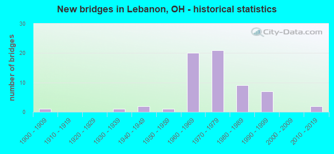
- New bridges - historical statistics
- 11900-1909
- 11930-1939
- 21940-1949
- 11950-1959
- 201960-1969
- 211970-1979
- 91980-1989
- 71990-1999
- 22010-2019

- Reconstructed bridges - Historical Statistics
- 21970-1979
- 21980-1989
- 61990-1999
- 42000-2009
- 12010-2019


- Bridge Condition - Deck
- 4.2%Excellent
- 22.9%Very good
- 33.3%Good
- 25.0%Satisfactory
- 12.5%Fair
- 2.1%Poor

- Bridge Condition - Superstructure
- 4.2%Excellent
- 29.2%Very good
- 25.0%Good
- 29.2%Satisfactory
- 10.4%Fair
- 2.1%Poor

- Bridge Condition - Substructure
- 2.1%Excellent
- 27.1%Very good
- 39.6%Good
- 18.8%Satisfactory
- 8.3%Fair
- 4.2%Poor

- Bridge Condition - Channel
- 2.1%Excellent
- 38.3%Very good
- 23.4%Good
- 29.8%Satisfactory
- 4.3%Fair
- 2.1%Poor

- Bridge Condition - Culverts
- 50.0%Good
- 16.7%Satisfactory
- 16.7%Fair
- 16.7%Serious
Find on map >> Show street view
Structure Number: 8334196, Location: 0.11 mi W of SR 123 (Lat: 39.451111, Lng: -84.238211), Route carried "on" structure: County highway C0020, Year Built: 1979, Status: Open, Structure Length: 1.59m (5.22ft), Average Daily Traffic: 2,560 (year 2015), Truck Traffic: 8%, Average Future Daily Traffic: 3,553 (year 2035), Design Load: HS 20, Features Intersected: REEDERS RUN, Facility Carried by Structure: GREENTREE ROAD
Minimum Vertical Clearance: 30+ m (98+ ft), Kilometerpoint: 9.946, Lanes on structure: 2, Owner: County Highway Agency, Approaching Roadway Width: 7.6m (24.9ft), Material/Design: Prestressed concrete, Design/Construction: Box Beam or Girders - Multiple, Number Of Spans In Main Unit: 1, Length of Maximum Span: 15.9m (52.2ft), Curb-To-Curb Width: 7.3m (24.0ft), Out-to-Out Width: 7.3m (24.0ft)
Condition: Deck: Very good, Superstructure: Very good, Substructure: Satisfactory, Channel: Satisfactory, Operating Rating: 55.1 metric tons, Method Used To Determine Operating Rating: Load Factor (LF) rating reported by rating factor (RF) method using MS18 loading, Inventory Rating: 35.6 metric tons, Method Used To Determine Inventory Rating: Load Factor (LF) rating reported by rating factor (RF) method using MS18 loading, Structural Evaluation: Equal to present minimum criteria, Deck Geometry: High priority of replacement, Waterway Adequacy: Equal to present desirable criteria, Approach Roadway Alignment: Better than present minimum criteria, Designated Inspection Frequency: Every 12 months, Inspection Date: December 2021, Deck Structure Type: Concrete Cast-file-Place, Wearing Surface/Protective System: Wearing Surface: Bituminous
Find on map >> Show street view
Structure Number: 8334439, Location: 0.40 mi W of US RT 42 (Lat: 39.421869, Lng: -84.242739), Route carried "on" structure: County highway T0071, Year Built: 1982, Status: Posted for load, Structure Length: 2.62m (8.60ft), Average Daily Traffic: 983 (year 2015), Truck Traffic: 5%, Average Future Daily Traffic: 1,364 (year 2035), Design Load: HS 20+Mod, Features Intersected: TURTLE CREEK, Facility Carried by Structure: MCCLURE ROAD
Minimum Vertical Clearance: 30+ m (98+ ft), Kilometerpoint: 0.628, Lanes on structure: 2, Owner: County Highway Agency, Approaching Roadway Width: 7.3m (24.0ft), Skew: 1 degrees, Material/Design: Prestressed concrete, Design/Construction: Box Beam or Girders - Multiple, Number Of Spans In Main Unit: 1, Length of Maximum Span: 24.4m (80.1ft), Curb-To-Curb Width: 7.3m (24.0ft), Out-to-Out Width: 7.3m (24.0ft)
Condition: Deck: Poor, Superstructure: Poor, Substructure: Very good, Channel: Good, Operating Rating: 9.7 metric tons, Method Used To Determine Operating Rating: Load and Resistance Factor Rating (LRFR) rating reported by rating factor(RF) method using HL-93 loadings, Inventory Rating: 3.2 metric tons, Method Used To Determine Inventory Rating: Load and Resistance Factor Rating (LRFR) rating reported by rating factor(RF) method using HL-93 loadings, Structural Evaluation: High priority of corrective action, Deck Geometry: Meets minimum limits, Waterway Adequacy: Equal to present desirable criteria, Approach Roadway Alignment: Somewhat better than minimum adequacy, Bridge Posting: Required (Relationship of Operating Rating to Maximum Legal Load: > 39.9% below), Designated Inspection Frequency: Every 12 months, Inspection Date: December 2021, Deck Structure Type: Concrete Cast-file-Place, Wearing Surface/Protective System: Wearing Surface: Bituminous
Find on map >> Show street view
Structure Number: 8334463, Location: 0.40 mi N of TR 82 (Lat: 39.387981, Lng: -84.200211), Route carried "on" structure: County highway T0081, Year Built: 1982, Year Reconstructed: 2008, Status: Open, Structure Length: 0.88m (2.89ft), Average Daily Traffic: 347 (year 2015), Truck Traffic: 5%, Average Future Daily Traffic: 482 (year 2035), Design Load: HS 20, Features Intersected: DRY RUN, Facility Carried by Structure: DRY RUN ROAD
Minimum Vertical Clearance: 30+ m (98+ ft), Kilometerpoint: 1.963, Lanes on structure: 1, Owner: County Highway Agency, Approaching Roadway Width: 4.9m (16.1ft), Material/Design: Steel, Design/Construction: Stringer/Multi-beam, Number Of Spans In Main Unit: 1, Length of Maximum Span: 7.6m (24.9ft), Curb-To-Curb Width: 4.9m (16.1ft), Out-to-Out Width: 4.9m (16.1ft)
Condition: Deck: Good, Superstructure: Fair, Substructure: Fair, Channel: Satisfactory, Operating Rating: 87.5 metric tons, Method Used To Determine Operating Rating: Load Factor (LF) rating reported by rating factor (RF) method using MS18 loading, Inventory Rating: 61.6 metric tons, Method Used To Determine Inventory Rating: Load Factor (LF) rating reported by rating factor (RF) method using MS18 loading, Structural Evaluation: Somewhat better than minimum adequacy, Deck Geometry: High priority of replacement, Waterway Adequacy: Equal to present desirable criteria, Approach Roadway Alignment: Meets minimum limits, Designated Inspection Frequency: Every 12 months, Inspection Date: November 2021, Deck Structure Type: Wood or Timber, Wearing Surface/Protective System: Wearing Surface: Wood or Timber
Find on map >> Show street view
Structure Number: 8334641, Location: 0.49 mi W of TR 42 (Lat: 39.493031, Lng: -84.170000), Route carried "on" structure: County highway C0230, Year Built: 1981, Status: Open, Structure Length: 1.86m (6.10ft), Average Daily Traffic: 4,041 (year 2015), Truck Traffic: 7%, Average Future Daily Traffic: 5,609 (year 2035), Features Intersected: CLEAR CREEK, Facility Carried by Structure: OLD S.R. 122
Minimum Vertical Clearance: 30+ m (98+ ft), Kilometerpoint: 2.849, Lanes on structure: 2, Owner: County Highway Agency, Approaching Roadway Width: 13.4m (44.0ft), Material/Design: Concrete continuous, Design/Construction: Slab, Number Of Spans In Main Unit: 3, Length of Maximum Span: 6.7m (22.0ft), Curb-To-Curb Width: 13.4m (44.0ft), Out-to-Out Width: 13.8m (45.3ft)
Condition: Deck: Satisfactory, Superstructure: Satisfactory, Substructure: Satisfactory, Channel: Very good, Operating Rating: 40.8 metric tons, Method Used To Determine Operating Rating: Field evaluation and documented engineering judgment, Inventory Rating: 32.7 metric tons, Method Used To Determine Inventory Rating: Field evaluation and documented engineering judgment, Structural Evaluation: Equal to present minimum criteria, Deck Geometry: Better than present minimum criteria, Waterway Adequacy: Equal to present desirable criteria, Approach Roadway Alignment: Equal to present desirable criteria, Designated Inspection Frequency: Every 12 months, Inspection Date: November 2021, Deck Structure Type: Concrete Cast-file-Place, Wearing Surface/Protective System: Wearing Surface: Bituminous
Find on map >> Show street view
Structure Number: 8335109, Location: 0.28 mi N of CR 7 (Lat: 39.434139, Lng: -84.158581), Route carried "on" structure: County highway T0095, Year Built: 1988, Status: Open, Structure Length: 0.73m (2.40ft), Average Daily Traffic: 351 (year 2015), Truck Traffic: 7%, Average Future Daily Traffic: 487 (year 2035), Design Load: HS 20, Features Intersected: BR. OF TURTLE CREEK, Facility Carried by Structure: LIBERTY-KEUTER
Minimum Vertical Clearance: 30+ m (98+ ft), Kilometerpoint: 1.754, Lanes on structure: 2, Owner: County Highway Agency, Approaching Roadway Width: 6.1m (20.0ft), Material/Design: Aluminum, Iron, Design/Construction: Culvert, Number Of Spans In Main Unit: 1, Length of Maximum Span: 7.3m (24.0ft)
Condition: Channel: Very good, Culverts: Good, Operating Rating: 64.8 metric tons, Method Used To Determine Operating Rating: Load Factor (LF) rating reported by rating factor (RF) method using MS18 loading, Inventory Rating: 38.9 metric tons, Method Used To Determine Inventory Rating: Load Factor (LF) rating reported by rating factor (RF) method using MS18 loading, Structural Evaluation: Better than present minimum criteria, Waterway Adequacy: Equal to present desirable criteria, Approach Roadway Alignment: Equal to present minimum criteria, Designated Inspection Frequency: Every 24 months, Inspection Date: December 2021
Find on map >> Show street view
Structure Number: 8335338, Location: 0.02 mi N of M 38 (Lat: 39.371989, Lng: -84.251239), Route carried "on" structure: County highway M0015, Year Built: 2011, Status: Open, Structure Length: 2.50m (8.20ft), Average Daily Traffic: 4,254 (year 2015), Truck Traffic: 14%, Average Future Daily Traffic: 5,905 (year 2035), Design Load: HL 93, Features Intersected: MUDDY CREEK, Facility Carried by Structure: COLUMBIA ROAD
Minimum Vertical Clearance: 30+ m (98+ ft), Kilometerpoint: 8.336, Lanes on structure: 3, Owner: County Highway Agency, Approaching Roadway Width: 11.0m (36.1ft), Material/Design: Prestressed concrete, Design/Construction: Box Beam or Girders - Multiple, Number Of Spans In Main Unit: 1, Length of Maximum Span: 24.4m (80.1ft), Curb-To-Curb Width: 15.9m (52.2ft), Out-to-Out Width: 15.9m (52.2ft)
Condition: Deck: Excellent, Superstructure: Excellent, Substructure: Excellent, Channel: Very good, Operating Rating: 84.2 metric tons, Method Used To Determine Operating Rating: Load Factor (LF) rating reported by rating factor (RF) method using MS18 loading, Inventory Rating: 51.8 metric tons, Method Used To Determine Inventory Rating: Load Factor (LF) rating reported by rating factor (RF) method using MS18 loading, Structural Evaluation: Superior to present desirable criteria, Deck Geometry: Better than present minimum criteria, Waterway Adequacy: Equal to present desirable criteria, Approach Roadway Alignment: Equal to present desirable criteria, Designated Inspection Frequency: Every 24 months, Inspection Date: November 2021, Deck Structure Type: Concrete Cast-file-Place, Wearing Surface/Protective System: Wearing Surface: Monolithic Concrete, Deck Protection: Epoxy Coated Reinforcing
Find on map >> Show street view
Structure Number: 8360006, Location: 0.4 MI E of N Broadway St (Lat: 39.456511, Lng: -84.196039), Route carried "on" structure: City street MILLR, Year Built: 1996, Status: Open, Structure Length: 1.04m (3.41ft), Average Daily Traffic: 13,801 (year 2018), Truck Traffic: 5%, Average Future Daily Traffic: 19,156 (year 2038), Design Load: HS 20, Features Intersected: N Fork Turtle Creek, Facility Carried by Structure: MILLER ROAD
Minimum Vertical Clearance: 30+ m (98+ ft), Kilometerpoint: 0.579, Lanes on structure: 2, Owner: City or Municipal Highway Agency, Approaching Roadway Width: 8.5m (27.9ft), Skew: 1 degrees, Material/Design: Concrete, Design/Construction: Culvert, Number Of Spans In Main Unit: 1, Length of Maximum Span: 9.8m (32.2ft)
Condition: Channel: Satisfactory, Culverts: Good, Operating Rating: 97.2 metric tons, Method Used To Determine Operating Rating: Load Factor (LF) rating reported by rating factor (RF) method using MS18 loading, Inventory Rating: 74.5 metric tons, Method Used To Determine Inventory Rating: Load Factor (LF) rating reported by rating factor (RF) method using MS18 loading, Structural Evaluation: Better than present minimum criteria, Waterway Adequacy: Superior to present desirable criteria, Approach Roadway Alignment: Equal to present desirable criteria, Designated Inspection Frequency: Every 24 months, Inspection Date: May 2021
Find on map >> Show street view
Structure Number: 8360065, Location: 0.2 MI S of E MAIN ST (Lat: 39.430969, Lng: -84.204189), Route carried "on" structure: City street MR318, Year Built: 1971, Status: Open, Structure Length: 3.65m (11.98ft), Average Daily Traffic: 1,500 (year 1977), Truck Traffic: 5%, Average Future Daily Traffic: 2,082 (year 1997), Design Load: HS 20+Mod, Features Intersected: TURTLE CREEK, Facility Carried by Structure: S EAST STREET
Minimum Vertical Clearance: 30+ m (98+ ft), Kilometerpoint: 1.014, Lanes on structure: 2, Owner: City or Municipal Highway Agency, Approaching Roadway Width: 11.9m (39.0ft), Skew: 3 degrees, Material/Design: Concrete continuous, Design/Construction: Slab, Number Of Spans In Main Unit: 3, Length of Maximum Span: 13.7m (44.9ft), Curb or Sidewalk Widths: Left: 1.2m (3.9ft), Right: 1.2m (3.9ft), Curb-To-Curb Width: 11.9m (39.0ft), Out-to-Out Width: 14.9m (48.9ft)
Condition: Deck: Satisfactory, Superstructure: Satisfactory, Substructure: Good, Channel: Satisfactory, Operating Rating: 38.9 metric tons, Method Used To Determine Operating Rating: Load Factor (LF) rating reported by rating factor (RF) method using MS18 loading, Inventory Rating: 22.7 metric tons, Method Used To Determine Inventory Rating: Load Factor (LF) rating reported by rating factor (RF) method using MS18 loading, Structural Evaluation: Equal to present minimum criteria, Deck Geometry: Equal to present minimum criteria, Waterway Adequacy: Equal to present desirable criteria, Approach Roadway Alignment: Equal to present desirable criteria, Designated Inspection Frequency: Every 12 months, Inspection Date: May 2021, Deck Structure Type: Concrete Cast-file-Place, Wearing Surface/Protective System: Wearing Surface: Monolithic Concrete, Membrane: Other
Find on map >> Show street view
Structure Number: 8360073, Location: 0.2 MI S of E Main St (Lat: 39.431619, Lng: -84.207031), Route carried "on" structure: City street MECNC, Year Built: 1977, Year Reconstructed: 2012, Status: Open, Structure Length: 3.20m (10.50ft), Average Daily Traffic: 1,000 (year 2020), Truck Traffic: 5%, Average Future Daily Traffic: 1,388 (year 2040), Design Load: HS 20+Mod, Features Intersected: TURTLE CREEK, Facility Carried by Structure: S MECHANIC STREET
Minimum Vertical Clearance: 30+ m (98+ ft), Kilometerpoint: 0.386, Lanes on structure: 2, Owner: City or Municipal Highway Agency, Approaching Roadway Width: 12.5m (41.0ft), Skew: 2 degrees, Material/Design: Concrete continuous, Design/Construction: Slab, Number Of Spans In Main Unit: 3, Length of Maximum Span: 12.4m (40.7ft), Curb or Sidewalk Widths: Left: 1.5m (4.9ft), Right: 1.5m (4.9ft), Curb-To-Curb Width: 7.3m (24.0ft), Out-to-Out Width: 10.4m (34.1ft)
Condition: Deck: Good, Superstructure: Good, Substructure: Good, Channel: Good, Operating Rating: 51.8 metric tons, Method Used To Determine Operating Rating: Load Factor (LF) rating reported by rating factor (RF) method using MS18 loading, Inventory Rating: 32.4 metric tons, Method Used To Determine Inventory Rating: Load Factor (LF) rating reported by rating factor (RF) method using MS18 loading, Structural Evaluation: Better than present minimum criteria, Deck Geometry: Meets minimum limits, Waterway Adequacy: Equal to present desirable criteria, Approach Roadway Alignment: Equal to present desirable criteria, Designated Inspection Frequency: Every 24 months, Inspection Date: May 2021, Deck Structure Type: Concrete Cast-file-Place, Wearing Surface/Protective System: Wearing Surface: Integral Concrete
Find on map >> Show street view
Structure Number: 8360081, Location: 0.1 MI S of E South St (Lat: 39.431039, Lng: -84.208561), Route carried "on" structure: County highway CR511, Year Built: 1900, Status: Open, Structure Length: 3.05m (10.01ft), Average Daily Traffic: 11,006 (year 2021), Truck Traffic: 5%, Average Future Daily Traffic: 15,276 (year 2041), Design Load: H 15, Features Intersected: TURTLE CREEK, Facility Carried by Structure: S BROADWAY STREET
Minimum Vertical Clearance: 30+ m (98+ ft), Kilometerpoint: 0.644, Lanes on structure: 2, Owner: City or Municipal Highway Agency, Approaching Roadway Width: 12.2m (40.0ft), Skew: 3 degrees, Material/Design: Concrete, Design/Construction: Arch - Deck, Number Of Spans In Main Unit: 2, Length of Maximum Span: 11.3m (37.1ft), Curb or Sidewalk Widths: Left: 1.8m (5.9ft), Right: 1.8m (5.9ft), Curb-To-Curb Width: 6.7m (22.0ft), Out-to-Out Width: 11.0m (36.1ft)
Condition: Deck: Satisfactory, Superstructure: Satisfactory, Substructure: Satisfactory, Channel: Satisfactory, Operating Rating: 48.6 metric tons, Method Used To Determine Operating Rating: Load Factor (LF) rating reported by rating factor (RF) method using MS18 loading, Inventory Rating: 29.2 metric tons, Method Used To Determine Inventory Rating: Load Factor (LF) rating reported by rating factor (RF) method using MS18 loading, Structural Evaluation: Equal to present minimum criteria, Deck Geometry: High priority of replacement, Waterway Adequacy: Equal to present desirable criteria, Approach Roadway Alignment: Equal to present desirable criteria, Designated Inspection Frequency: Every 12 months, Inspection Date: May 2021, Wearing Surface/Protective System: Wearing Surface: Bituminous
Find on map >> Show street view
Structure Number: 8360138, Location: 0.2 MI SE of E Main St (Lat: 39.431111, Lng: -84.194639), Route carried "on" structure: City street MR272, Year Built: 1984, Status: Posted for load-capacity, Structure Length: 2.59m (8.50ft), Average Daily Traffic: 289 (year 2018), Truck Traffic: 3%, Average Future Daily Traffic: 402 (year 2038), Design Load: HS 20, Features Intersected: TURTLE CREEK, Facility Carried by Structure: JAMESON LANE
Minimum Vertical Clearance: 30+ m (98+ ft), Kilometerpoint: 0.391, Lanes on structure: 1, Owner: City or Municipal Highway Agency, Approaching Roadway Width: 6.4m (21.0ft), Material/Design: Prestressed concrete, Design/Construction: Box Beam or Girders - Multiple, Number Of Spans In Main Unit: 1, Length of Maximum Span: 25.0m (82.0ft), Curb-To-Curb Width: 4.9m (16.1ft), Out-to-Out Width: 4.9m (16.1ft)
Condition: Deck: Satisfactory, Superstructure: Satisfactory, Substructure: Good, Channel: Satisfactory, Operating Rating: 64.8 metric tons, Method Used To Determine Operating Rating: Load Factor (LF) rating reported by rating factor (RF) method using MS18 loading, Inventory Rating: 38.9 metric tons, Method Used To Determine Inventory Rating: Load Factor (LF) rating reported by rating factor (RF) method using MS18 loading, Structural Evaluation: Equal to present minimum criteria, Deck Geometry: High priority of replacement, Waterway Adequacy: Equal to present desirable criteria, Approach Roadway Alignment: Meets minimum limits, Designated Inspection Frequency: Every 12 months, Inspection Date: May 2021, Deck Structure Type: Other, Wearing Surface/Protective System: Wearing Surface: Bituminous, Membrane: Preformed Fabric
Find on map >> Show street view
Structure Number: 8360189, Location: AT N Water St (Lat: 39.434619, Lng: -84.211300), Route carried "on" structure: City street MR337, Year Built: 1982, Status: Open, Structure Length: 1.55m (5.09ft), Average Daily Traffic: 1,000 (year 1951), Truck Traffic: 5%, Average Future Daily Traffic: 1,388 (year 1971), Design Load: HS 20, Features Intersected: NORTH FORK TURTLE CREEK, Facility Carried by Structure: W MULBERRY STREET
Minimum Vertical Clearance: 30+ m (98+ ft), Kilometerpoint: 0.338, Lanes on structure: 2, Owner: City or Municipal Highway Agency, Approaching Roadway Width: 12.2m (40.0ft), Material/Design: Prestressed concrete, Design/Construction: Box Beam or Girders - Multiple, Number Of Spans In Main Unit: 1, Length of Maximum Span: 15.2m (49.9ft), Curb or Sidewalk Widths: Left: 1.2m (3.9ft), Right: 0.0m, Curb-To-Curb Width: 7.3m (24.0ft), Out-to-Out Width: 8.5m (27.9ft)
Condition: Deck: Good, Superstructure: Good, Substructure: Good, Channel: Good, Operating Rating: 68.0 metric tons, Method Used To Determine Operating Rating: Load Factor (LF) rating reported by rating factor (RF) method using MS18 loading, Inventory Rating: 38.9 metric tons, Method Used To Determine Inventory Rating: Load Factor (LF) rating reported by rating factor (RF) method using MS18 loading, Structural Evaluation: Better than present minimum criteria, Deck Geometry: Meets minimum limits, Waterway Adequacy: Equal to present desirable criteria, Approach Roadway Alignment: Equal to present desirable criteria, Designated Inspection Frequency: Every 24 months, Inspection Date: May 2021, Deck Structure Type: Other, Wearing Surface/Protective System: Wearing Surface: Bituminous
Find on map >> Show street view
Structure Number: 8360219, Location: 300 FT N OF CONCORD DR (Lat: 39.426511, Lng: -84.216189), Route carried "on" structure: City street MR325, Year Built: 2013, Status: Open, Structure Length: 0.79m (2.59ft), Average Daily Traffic: 200 (year 2013), Truck Traffic: 3%, Average Future Daily Traffic: 278 (year 2033), Design Load: HL 93, Features Intersected: BAINUMS CREEK, Facility Carried by Structure: S WEST STREET
Minimum Vertical Clearance: 30+ m (98+ ft), Kilometerpoint: 0.113, Lanes on structure: 2, Owner: City or Municipal Highway Agency, Approaching Roadway Width: 8.5m (27.9ft), Material/Design: Concrete, Design/Construction: Culvert, Number Of Spans In Main Unit: 1, Length of Maximum Span: 7.3m (24.0ft)
Condition: Channel: Satisfactory, Culverts: Good, Operating Rating: 42.1 metric tons, Method Used To Determine Operating Rating: Load and Resistance Factor Rating (LRFR) rating reported by rating factor(RF) method using HL-93 loadings, Inventory Rating: 32.4 metric tons, Method Used To Determine Inventory Rating: Load and Resistance Factor Rating (LRFR) rating reported by rating factor(RF) method using HL-93 loadings, Structural Evaluation: Better than present minimum criteria, Waterway Adequacy: Better than present minimum criteria, Approach Roadway Alignment: Equal to present desirable criteria, Designated Inspection Frequency: Every 24 months, Inspection Date: May 2021
Find on map >> Show street view
Structure Number: 8360227, Location: At Deerfield Road (Lat: 39.422519, Lng: -84.205289), Route carried "on" structure: City street MR318, Year Built: 1991, Status: Open, Structure Length: 0.91m (2.99ft), Average Daily Traffic: 11,006 (year 2015), Truck Traffic: 5%, Average Future Daily Traffic: 15,276 (year 2035), Features Intersected: TRB TURTL CR (BAINUMS CR, Facility Carried by Structure: S EAST STREET
Minimum Vertical Clearance: 30+ m (98+ ft), Kilometerpoint: 0.016, Lanes on structure: 3, Owner: City or Municipal Highway Agency, Approaching Roadway Width: 12.8m (42.0ft), Material/Design: Concrete, Design/Construction: Frame, Number Of Spans In Main Unit: 1, Length of Maximum Span: 8.5m (27.9ft), Curb or Sidewalk Widths: Left: 1.5m (4.9ft), Right: 1.2m (3.9ft), Curb-To-Curb Width: 12.8m (42.0ft), Out-to-Out Width: 25.9m (85.0ft)
Condition: Deck: Satisfactory, Superstructure: Satisfactory, Substructure: Satisfactory, Channel: Poor, Operating Rating: 68.0 metric tons, Method Used To Determine Operating Rating: Load Factor (LF) rating reported by rating factor (RF) method using MS18 loading, Inventory Rating: 42.1 metric tons, Method Used To Determine Inventory Rating: Load Factor (LF) rating reported by rating factor (RF) method using MS18 loading, Structural Evaluation: Equal to present minimum criteria, Deck Geometry: Meets minimum limits, Waterway Adequacy: Better than present minimum criteria, Approach Roadway Alignment: Better than present minimum criteria, Designated Inspection Frequency: Every 12 months, Inspection Date: May 2021, Deck Structure Type: Concrete Cast-file-Place, Wearing Surface/Protective System: Wearing Surface: Bituminous
Find on map >> Show street view
Structure Number: 8360235, Location: At Turtlecreek Rd (Lat: 39.381031, Lng: -84.238200), Route carried "on" structure: City street KINGV, Year Built: 1985, Status: Open, Structure Length: 6.92m (22.70ft), Average Daily Traffic: 1,000 (year 2020), Truck Traffic: 5%, Average Future Daily Traffic: 1,388 (year 2040), Design Load: HS 20+Mod, Features Intersected: TURTLE CREEK, Facility Carried by Structure: KINGSVIEW DRIVE
Minimum Vertical Clearance: 30+ m (98+ ft), Kilometerpoint: 1.175, Lanes on structure: 2, Owner: City or Municipal Highway Agency, Approaching Roadway Width: 8.5m (27.9ft), Material/Design: Prestressed concrete continuous, Design/Construction: Box Beam or Girders - Multiple, Number Of Spans In Main Unit: 3, Length of Maximum Span: 22.9m (75.1ft), Curb or Sidewalk Widths: Left: 0.9m (3.0ft), Right: 0.9m (3.0ft), Curb-To-Curb Width: 8.5m (27.9ft), Out-to-Out Width: 11.0m (36.1ft)
Condition: Deck: Fair, Superstructure: Fair, Substructure: Fair, Channel: Fair, Operating Rating: 51.8 metric tons, Method Used To Determine Operating Rating: Load and Resistance Factor Rating (LRFR) rating reported by rating factor(RF) method using HL-93 loadings, Inventory Rating: 38.9 metric tons, Method Used To Determine Inventory Rating: Load and Resistance Factor Rating (LRFR) rating reported by rating factor(RF) method using HL-93 loadings, Structural Evaluation: Somewhat better than minimum adequacy, Deck Geometry: Somewhat better than minimum adequacy, Waterway Adequacy: Equal to present desirable criteria, Approach Roadway Alignment: Equal to present desirable criteria, Designated Inspection Frequency: Every 12 months, Inspection Date: May 2021, Deck Structure Type: Other, Wearing Surface/Protective System: Wearing Surface: Bituminous, Membrane: Built-up
Find on map >> Show street view
Structure Number: 8301174, Location: .4 MI N LEBANON S CORP (Lat: 39.405500, Lng: -84.208000), Route carried "under" structure: State highway 48, Year Built: 1971, Structure Length: 0. m, Average Daily Traffic: 31,700 (year 2015), Truck Traffic: 6%, Features Intersected: TURTLECREEK-UNION ROAD, Facility Carried by Structure: TURTLECREEK UNION
Minimum Vertical Clearance: 4.90m (16.08ft), Kilometerpoint: 18.572, Lanes on structure: 2, Lanes under structure: 4, Material/Design: Steel continuous, Design/Construction: Stringer/Multi-beam, Length of Maximum Span: 19.2m (63.0ft)
Find on map >> Show street view
Structure Number: 8301921, Location: 1.2 MI N OF SR 741 (Lat: 39.371019, Lng: -84.250039), Route carried "under" structure: County highway 38, Year Built: 1964, Structure Length: 0. m, Average Daily Traffic: 7,785 (year 2015), Truck Traffic: 5%, Features Intersected: I71*S, Facility Carried by Structure: SB IR 71
Minimum Vertical Clearance: 5.56m (18.24ft), Kilometerpoint: 92.215, Lanes on structure: 3, Lanes under structure: 2, Material/Design: Steel continuous, Design/Construction: Stringer/Multi-beam, Length of Maximum Span: 32.0m (105.0ft)
Find on map >> Show street view
Structure Number: 8301956, Location: 1.2 MI N OF SR 741 (Lat: 39.370850, Lng: -84.249769), Route carried "under" structure: County highway 38, Year Built: 1964, Structure Length: 0. m, Average Daily Traffic: 7,785 (year 2015), Truck Traffic: 5%, Features Intersected: I71*N, Facility Carried by Structure: NB IR 71
Minimum Vertical Clearance: 5.49m (18.01ft), Kilometerpoint: 92.215, Lanes on structure: 3, Lanes under structure: 2, Material/Design: Steel continuous, Design/Construction: Stringer/Multi-beam, Length of Maximum Span: 32.0m (105.0ft)
Find on map >> Show street view
Structure Number: 8302049, Location: .8 MI S OF SR 48 (Lat: 39.380061, Lng: -84.235781), Route carried "under" structure: County highway 72, Year Built: 1965, Structure Length: 0. m, Average Daily Traffic: 951 (year 2015), Truck Traffic: 5%, Features Intersected: I71*S, Facility Carried by Structure: SB IR 71
Minimum Vertical Clearance: 4.80m (15.75ft), Kilometerpoint: 0.998, Lanes on structure: 3, Lanes under structure: 2, Material/Design: Steel continuous, Design/Construction: Stringer/Multi-beam, Length of Maximum Span: 37.2m (122.0ft)
Find on map >> Show street view
Structure Number: 8302073, Location: .8 MI S OF SR 48 (Lat: 39.379900, Lng: -84.235450), Route carried "under" structure: County highway 72, Year Built: 1965, Structure Length: 0. m, Average Daily Traffic: 951 (year 2015), Truck Traffic: 5%, Features Intersected: I71*N, Facility Carried by Structure: NB IR 71
Minimum Vertical Clearance: 4.42m (14.50ft), Kilometerpoint: 0.998, Lanes on structure: 3, Lanes under structure: 2, Material/Design: Steel continuous, Design/Construction: Stringer/Multi-beam, Length of Maximum Span: 37.2m (122.0ft)
Find on map >> Show street view
Structure Number: 8302162, Location: 1.6 MI S OF SR 123 (Lat: 39.402881, Lng: -84.178289), Route carried "under" structure: Interstate 71, Year Built: 1964, Structure Length: 0. m, Average Daily Traffic: 44,274 (year 2015), Truck Traffic: 11%, Features Intersected: C35(STUBBS MILL ROAD), Facility Carried by Structure: STUBBS MILL RD C35
Minimum Vertical Clearance: 5.51m (18.08ft), Kilometerpoint: 17.767, Lanes on structure: 2, Lanes under structure: 4, Material/Design: Steel continuous, Design/Construction: Stringer/Multi-beam, Length of Maximum Span: 25.3m (83.0ft)
Find on map >> Show street view
Structure Number: 8302227, Location: 1 MI N OF SR 123 (Lat: 39.414261, Lng: -84.132989), Route carried "under" structure: Interstate 71, Year Built: 1964, Structure Length: 0. m, Average Daily Traffic: 44,150 (year 2015), Truck Traffic: 11%, Features Intersected: T39(WAYNESVILLE ROAD), Facility Carried by Structure: WAYNESVILLE RD T39
Minimum Vertical Clearance: 4.88m (16.01ft), Kilometerpoint: 22.064, Lanes on structure: 2, Lanes under structure: 4, Material/Design: Steel continuous, Design/Construction: Stringer/Multi-beam, Length of Maximum Span: 25.3m (83.0ft)
Find on map >> Show street view
Structure Number: 8304416, Location: OVER IR 71 (Lat: 39.412581, Lng: -84.152561), Route carried "under" structure: Interstate 71, Year Built: 1964, Structure Length: 0. m, Average Daily Traffic: 39,426 (year 2015), Truck Traffic: 11%, Features Intersected: S123, Facility Carried by Structure: SR 123
Minimum Vertical Clearance: 4.95m (16.24ft), Kilometerpoint: 20.358, Lanes on structure: 4, Lanes under structure: 4, Material/Design: Steel continuous, Design/Construction: Stringer/Multi-beam, Length of Maximum Span: 28.2m (92.5ft)
Find on map >> Show street view
Structure Number: 830556, Location: OVER SR 48 & 123 (Lat: 39.431900, Lng: -84.190581), Route carried "under" structure: State highway 48, Year Built: 1971, Structure Length: 0. m, Average Daily Traffic: 10,259 (year 2015), Truck Traffic: 6%, Features Intersected: S48J*S(S48*S FUTURE)
Minimum Vertical Clearance: 4.65m (15.26ft), Kilometerpoint: 22.080, Lanes on structure: 2, Lanes under structure: 5, Material/Design: Steel continuous, Design/Construction: Stringer/Multi-beam, Length of Maximum Span: 25.9m (85.0ft)
Find on map >> Show street view
Structure Number: 8305579, Location: OVER SR 48 & 123 (Lat: 39.431850, Lng: -84.190339), Route carried "under" structure: State highway 48, Year Built: 1971, Structure Length: 0. m, Average Daily Traffic: 10,259 (year 2015), Truck Traffic: 6%, Features Intersected: S48J*N(S48*N FUTURE)
Minimum Vertical Clearance: 4.50m (14.76ft), Kilometerpoint: 22.064, Lanes on structure: 2, Lanes under structure: 5, Material/Design: Steel continuous, Design/Construction: Stringer/Multi-beam, Length of Maximum Span: 25.9m (85.0ft)