Bridge Statistics for Lee, Massachusetts (MA)
Condition, Traffic, Stress, Structural Evaluation, Project Costs
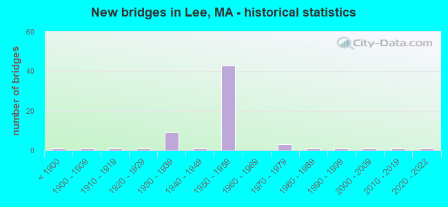
- New bridges - historical statistics
- 1Before 1900
- 11900-1909
- 11910-1919
- 11920-1929
- 91930-1939
- 11940-1949
- 431950-1959
- 31970-1979
- 11980-1989
- 11990-1999
- 12000-2009
- 12010-2019
- 12020-2022

- Reconstructed bridges - Historical Statistics
- 11920-1929
- 11930-1939
- 01940-1949
- 11950-1959
- 11960-1969
- 01970-1979
- 171980-1989
- 51990-1999
- 02000-2009
- 12010-2019


- Bridge Condition - Deck
- 2.4%Excellent
- 4.9%Very good
- 56.1%Good
- 22.0%Satisfactory
- 12.2%Fair
- 2.4%Serious

- Bridge Condition - Superstructure
- 2.4%Excellent
- 7.3%Very good
- 26.8%Good
- 36.6%Satisfactory
- 17.1%Fair
- 9.8%Poor

- Bridge Condition - Substructure
- 2.4%Excellent
- 2.4%Very good
- 43.9%Good
- 34.1%Satisfactory
- 17.1%Fair

- Bridge Condition - Channel
- 3.8%Excellent
- 7.7%Very good
- 42.3%Good
- 26.9%Satisfactory
- 11.5%Fair
- 3.8%Poor
- 3.8%Serious

- Bridge Condition - Culverts
- 33.3%Good
- 66.7%Satisfactory
Find on map >> Show street view
Structure Number: G1103104QDEMNBI, Location: 500' SOUTH OF LEE T.L. (Lat: 42.256431, Lng: -73.285825), Route carried "on" structure: City street , Year Built: 1925, Year Reconstructed: 1960, Status: Open, Structure Length: 0.76m (2.49ft), Average Daily Traffic: 300 (year 2012), Truck Traffic: 6%, Average Future Daily Traffic: 158 (year 2031), Features Intersected: WATER WEST BROOK, Facility Carried by Structure: HWY BEARTOWN MTN
Minimum Vertical Clearance: 30+ m (98+ ft), Kilometerpoint: 0.000, Lanes on structure: 2, Owner: State Park, Forest, or Reservation Agency, Approaching Roadway Width: 5.2m (17.1ft), Skew: 1 degrees, Material/Design: Steel, Design/Construction: Stringer/Multi-beam, Number Of Spans In Main Unit: 1, Length of Maximum Span: 6.2m (20.3ft), Curb-To-Curb Width: 5.5m (18.0ft), Out-to-Out Width: 5.5m (18.0ft)
Condition: Deck: Good, Superstructure: Satisfactory, Substructure: Fair, Channel: Good, Operating Rating: 76.2 metric tons, Method Used To Determine Operating Rating: Allowable Stress (AS), Inventory Rating: 54.1 metric tons, Method Used To Determine Inventory Rating: Allowable Stress (AS), Structural Evaluation: Somewhat better than minimum adequacy, Deck Geometry: High priority of corrective action, Waterway Adequacy: Better than present minimum criteria, Approach Roadway Alignment: Equal to present minimum criteria, Length Of Structure Improvement: 0.80m (2.62ft), Designated Inspection Frequency: Every 24 months, Inspection Date: May 2020, Bridge Improvement Cost: $173,000, Roadway Improvement Cost: $18,000, Total Project Cost: $260,000 ( Estimate for 2022), Deck Structure Type: Concrete Cast-file-Place
Find on map >> Show street view
Structure Number: L050010DKDOT634, Location: 1.2 MI S JCT US20 73.85 (Lat: 42.282908, Lng: -73.249375), Route carried "on" structure: State highway 102, Year Built: 1905, Year Reconstructed: 1958, Status: Open, Structure Length: 1.42m (4.66ft), Average Daily Traffic: 7,512 (year 2017), Truck Traffic: 6%, Average Future Daily Traffic: 10,581 (year 2032), Design Load: H 20, Features Intersected: RR HRR
Minimum Vertical Clearance: 30+ m (98+ ft), Kilometerpoint: 18.016, Lanes on structure: 2, Base Highway Network: Yes, Owner: State Highway Agency, Approaching Roadway Width: 13.4m (44.0ft), Skew: 3 degrees, Material/Design: Steel, Design/Construction: Stringer/Multi-beam, Number Of Spans In Main Unit: 1, Length of Maximum Span: 12.4m (40.7ft), Curb or Sidewalk Widths: Left: 0.2m (0.7ft), Right: 1.5m (4.9ft), Curb-To-Curb Width: 12.2m (40.0ft), Out-to-Out Width: 15.2m (49.9ft)
Condition: Deck: Good, Superstructure: Good, Substructure: Good, Operating Rating: 43.4 metric tons, Method Used To Determine Operating Rating: Load Factor (LF), Inventory Rating: 25.9 metric tons, Method Used To Determine Inventory Rating: Load Factor (LF), Structural Evaluation: Equal to present minimum criteria, Deck Geometry: Somewhat better than minimum adequacy, Underclear: High priority of corrective action, Approach Roadway Alignment: Equal to present desirable criteria, Length Of Structure Improvement: 1.50m (4.92ft), Designated Inspection Frequency: Every 24 months, Inspection Date: November 2021, Bridge Improvement Cost: $896,000, Roadway Improvement Cost: $90,000, Total Project Cost: $1,345,000 ( Estimate for 2022), Deck Structure Type: Concrete Cast-file-Place, Wearing Surface/Protective System: Wearing Surface: Bituminous, Membrane: Built-up
Find on map >> Show street view
Structure Number: L05002057MUNNBI, Location: AT ROUTE 102 INT. (Lat: 42.276206, Lng: -73.285122), Route carried "on" structure: City street , Year Built: 1951, Status: Open, Structure Length: 3.81m (12.50ft), Average Daily Traffic: 300 (year 2021), Truck Traffic: 50%, Average Future Daily Traffic: 411 (year 2031), Design Load: H 20, Features Intersected: WATER HOUSATONIC RIVER, Facility Carried by Structure: HWY WILLOW ST
Minimum Vertical Clearance: 30+ m (98+ ft), Kilometerpoint: 0.000, Lanes on structure: 2, Owner: Town or Township Highway Agency, Approaching Roadway Width: 8.5m (27.9ft), Material/Design: Steel, Design/Construction: Truss - Thru, Number Of Spans In Main Unit: 1, Length of Maximum Span: 37.4m (122.7ft), Curb or Sidewalk Widths: Left: 0.0m, Right: 0.4m (1.3ft), Curb-To-Curb Width: 7.9m (25.9ft), Out-to-Out Width: 9.1m (29.9ft)
Condition: Deck: Satisfactory, Superstructure: Fair, Substructure: Satisfactory, Channel: Good, Operating Rating: 40.1 metric tons, Method Used To Determine Operating Rating: Load Factor (LF), Inventory Rating: 24.0 metric tons, Method Used To Determine Inventory Rating: Load Factor (LF), Structural Evaluation: Somewhat better than minimum adequacy, Deck Geometry: Somewhat better than minimum adequacy, Waterway Adequacy: Equal to present desirable criteria, Approach Roadway Alignment: Equal to present minimum criteria, Length Of Structure Improvement: 3.90m (12.80ft), Designated Inspection Frequency: Every 24 months, Critical Feature Inspection Frequency: Every 24 months, Inspection Date: July 2021, Critical Feature Inspection Date: July 2021, Bridge Improvement Cost: $1,395,000, Roadway Improvement Cost: $140,000, Total Project Cost: $2,093,000 ( Estimate for 2022), Deck Structure Type: Concrete Cast-file-Place, Wearing Surface/Protective System: Wearing Surface: Bituminous, Membrane: Built-up
Find on map >> Show street view
Structure Number: L05003058MUNNBI, Location: AT RTE 102 INTERSECTION (Lat: 42.278081, Lng: -73.275200), Route carried "on" structure: City street , Year Built: 1954, Status: Posted for load, Structure Length: 3.82m (12.53ft), Average Daily Traffic: 5,200 (year 2021), Truck Traffic: 6%, Average Future Daily Traffic: 7,896 (year 2031), Design Load: H 20, Features Intersected: WATER HOUSATONIC RIVER, Facility Carried by Structure: HWY MEADOW ST
Minimum Vertical Clearance: 30+ m (98+ ft), Kilometerpoint: 4.023, Lanes on structure: 2, Owner: Town or Township Highway Agency, Approaching Roadway Width: 7.9m (25.9ft), Material/Design: Steel, Design/Construction: Truss - Thru, Number Of Spans In Main Unit: 1, Length of Maximum Span: 37.4m (122.7ft), Curb or Sidewalk Widths: Left: 0.0m, Right: 1.5m (4.9ft), Curb-To-Curb Width: 7.9m (25.9ft), Out-to-Out Width: 9.1m (29.9ft)
Condition: Deck: Fair, Superstructure: Fair, Substructure: Satisfactory, Channel: Satisfactory, Operating Rating: 35.0 metric tons, Method Used To Determine Operating Rating: Load Factor (LF), Inventory Rating: 21.0 metric tons, Method Used To Determine Inventory Rating: Load Factor (LF), Structural Evaluation: Somewhat better than minimum adequacy, Deck Geometry: High priority of replacement, Waterway Adequacy: Somewhat better than minimum adequacy, Approach Roadway Alignment: Meets minimum limits, Length Of Structure Improvement: 3.90m (12.80ft), Designated Inspection Frequency: Every 24 months, Critical Feature Inspection Frequency: Every 24 months, Underwater Inspection Frequency: Every 36 months, Inspection Date: July 2021, Critical Feature Inspection Date: July 2021, Underwater Inspection Date: September 2020, Bridge Improvement Cost: $1,395,000, Roadway Improvement Cost: $140,000, Total Project Cost: $2,093,000 ( Estimate for 2022), Deck Structure Type: Concrete Cast-file-Place, Wearing Surface/Protective System: Wearing Surface: Bituminous, Membrane: Built-up
Find on map >> Show street view
Structure Number: L05004059MUNNBI, Location: .5 MI SOUTH OF RTE 102 (Lat: 42.273175, Lng: -73.269419), Route carried "on" structure: City street , Year Built: 1939, Status: Temporarily open, Structure Length: 1.22m (4.00ft), Average Daily Traffic: 647 (year 2018), Truck Traffic: 5%, Average Future Daily Traffic: 474 (year 2033), Design Load: H 15, Features Intersected: WATER POWDER MILL BROOK, Facility Carried by Structure: HWY MEADOW ST
Minimum Vertical Clearance: 30+ m (98+ ft), Kilometerpoint: 0.000, Lanes on structure: 2, Owner: Town or Township Highway Agency, Approaching Roadway Width: 4.2m (13.8ft), Skew: 3 degrees, Material/Design: Steel, Design/Construction: Stringer/Multi-beam, Number Of Spans In Main Unit: 1, Length of Maximum Span: 10.4m (34.1ft), Curb or Sidewalk Widths: Left: 0.2m (0.7ft), Right: 0.2m (0.7ft), Curb-To-Curb Width: 6.0m (19.7ft), Out-to-Out Width: 7.3m (24.0ft)
Condition: Deck: Serious, Superstructure: Poor, Substructure: Satisfactory, Channel: Poor, Structural Evaluation: High priority of replacement, Waterway Adequacy: Somewhat better than minimum adequacy, Approach Roadway Alignment: Somewhat better than minimum adequacy, Bridge Posting: Required (Relationship of Operating Rating to Maximum Legal Load: > 39.9% below), Length Of Structure Improvement: 1.90m (6.23ft), Designated Inspection Frequency: Every 24 months, Inspection Date: Febuary 2021, Bridge Improvement Cost: $1,344,000, Roadway Improvement Cost: $135,000, Total Project Cost: $2,017,000 ( Estimate for 2022), Deck Structure Type: Concrete Cast-file-Place, Wearing Surface/Protective System: Wearing Surface: Bituminous
Find on map >> Show street view
Structure Number: L05006016MUNNBI, Location: JUST S OF RTE 102 (Lat: 42.294767, Lng: -73.238956), Route carried "on" structure: City street , Year Built: 1938, Year Reconstructed: 1995, Status: Open, Structure Length: 1.84m (6.04ft), Average Daily Traffic: 1,400 (year 2014), Truck Traffic: 6%, Average Future Daily Traffic: 2,211 (year 2031), Design Load: HS 20, Features Intersected: WATER GOOSE POND BROOK, Facility Carried by Structure: HWY TYRINGHAM RD
Minimum Vertical Clearance: 30+ m (98+ ft), Kilometerpoint: 0.000, Lanes on structure: 2, Owner: Town or Township Highway Agency, Approaching Roadway Width: 7.9m (25.9ft), Skew: 4 degrees, Material/Design: Prestressed concrete, Design/Construction: Slab, Number Of Spans In Main Unit: 2, Length of Maximum Span: 8.4m (27.6ft), Curb or Sidewalk Widths: Left: 0.1m (0.3ft), Right: 1.5m (4.9ft), Curb-To-Curb Width: 7.9m (25.9ft), Out-to-Out Width: 10.4m (34.1ft)
Condition: Deck: Good, Superstructure: Good, Substructure: Good, Channel: Satisfactory, Operating Rating: 94.9 metric tons, Method Used To Determine Operating Rating: Allowable Stress (AS), Inventory Rating: 52.9 metric tons, Method Used To Determine Inventory Rating: Allowable Stress (AS), Structural Evaluation: Better than present minimum criteria, Deck Geometry: Meets minimum limits, Waterway Adequacy: Better than present minimum criteria, Approach Roadway Alignment: Better than present minimum criteria, Length Of Structure Improvement: 1.90m (6.23ft), Designated Inspection Frequency: Every 24 months, Inspection Date: Febuary 2021, Bridge Improvement Cost: $986,000, Roadway Improvement Cost: $99,000, Total Project Cost: $1,480,000 ( Estimate for 2022), Deck Structure Type: Concrete Precast Panels, Wearing Surface/Protective System: Wearing Surface: Bituminous, Membrane: Preformed Fabric, Deck Protection: Epoxy Coated Reinforcing
Find on map >> Show street view
Structure Number: L0500705AMUNNBI, Location: 300' S OF INT WITH RT 20 (Lat: 42.294292, Lng: -73.226053), Route carried "on" structure: City street , Year Built: 1970, Status: Open, Structure Length: 1.31m (4.30ft), Average Daily Traffic: 2,198 (year 2018), Truck Traffic: 6%, Average Future Daily Traffic: 158 (year 2033), Design Load: H 20, Features Intersected: WATER GREENWATER BROOK, Facility Carried by Structure: HWY FOREST ST
Minimum Vertical Clearance: 30+ m (98+ ft), Kilometerpoint: 0.000, Lanes on structure: 2, Owner: Town or Township Highway Agency, Approaching Roadway Width: 9.1m (29.9ft), Material/Design: Prestressed concrete, Design/Construction: Slab, Number Of Spans In Main Unit: 1, Length of Maximum Span: 12.6m (41.3ft), Curb or Sidewalk Widths: Left: 1.9m (6.2ft), Right: 0.5m (1.6ft), Curb-To-Curb Width: 9.1m (29.9ft), Out-to-Out Width: 12.3m (40.4ft)
Condition: Deck: Satisfactory, Superstructure: Satisfactory, Substructure: Good, Channel: Satisfactory, Operating Rating: 46.0 metric tons, Method Used To Determine Operating Rating: Load Factor (LF), Inventory Rating: 26.2 metric tons, Method Used To Determine Inventory Rating: Load Factor (LF), Structural Evaluation: Equal to present minimum criteria, Deck Geometry: Meets minimum limits, Waterway Adequacy: Better than present minimum criteria, Approach Roadway Alignment: Equal to present desirable criteria, Length Of Structure Improvement: 1.40m (4.59ft), Designated Inspection Frequency: Every 24 months, Inspection Date: Febuary 2022, Bridge Improvement Cost: $677,000, Roadway Improvement Cost: $68,000, Total Project Cost: $1,016,000 ( Estimate for 2022), Deck Structure Type: Concrete Precast Panels, Wearing Surface/Protective System: Wearing Surface: Bituminous
Find on map >> Show street view
Structure Number: L0500805BMUNNBI, Location: AT JCT W/ ROUTE 20 (Lat: 42.298828, Lng: -73.221000), Route carried "on" structure: City street , Year Built: 1939, Status: Posted for load, Structure Length: 1.22m (4.00ft), Average Daily Traffic: 240 (year 2015), Truck Traffic: 6%, Average Future Daily Traffic: 158 (year 2032), Design Load: H 15, Features Intersected: WATER GREENWATER BROOK, Facility Carried by Structure: HWY SILVER ST
Minimum Vertical Clearance: 30+ m (98+ ft), Kilometerpoint: 0.000, Lanes on structure: 2, Owner: Town or Township Highway Agency, Approaching Roadway Width: 7.9m (25.9ft), Skew: 1 degrees, Material/Design: Steel, Design/Construction: Stringer/Multi-beam, Number Of Spans In Main Unit: 1, Length of Maximum Span: 10.7m (35.1ft), Curb or Sidewalk Widths: Left: 0.1m (0.3ft), Right: 0.1m (0.3ft), Curb-To-Curb Width: 7.9m (25.9ft), Out-to-Out Width: 9.1m (29.9ft)
Condition: Deck: Fair, Superstructure: Poor, Substructure: Satisfactory, Channel: Fair, Operating Rating: 29.6 metric tons, Method Used To Determine Operating Rating: Load Factor (LF), Inventory Rating: 17.7 metric tons, Method Used To Determine Inventory Rating: Load Factor (LF), Structural Evaluation: Meets minimum limits, Deck Geometry: Somewhat better than minimum adequacy, Waterway Adequacy: Better than present minimum criteria, Approach Roadway Alignment: Equal to present minimum criteria, Bridge Posting: Required (Relationship of Operating Rating to Maximum Legal Load: 0.1 - 9.9% below), Length Of Structure Improvement: 1.90m (6.23ft), Designated Inspection Frequency: Every 12 months, Other Special Inspection Frequency: Every 12 months, Inspection Date: August 2021, Other Special Inspection Date: August 2021, Bridge Improvement Cost: $1,215,000, Roadway Improvement Cost: $122,000, Total Project Cost: $1,823,000 ( Estimate for 2022), Deck Structure Type: Concrete Cast-file-Place, Wearing Surface/Protective System: Wearing Surface: Bituminous
Find on map >> Show street view
Structure Number: L05010014MUNNBI, Location: JUST W OF RTE 20 (Lat: 42.303786, Lng: -73.251100), Route carried "on" structure: City street , Year Built: 1890, Year Reconstructed: 1932, Status: Open, Structure Length: 3.81m (12.50ft), Average Daily Traffic: 6,200 (year 2014), Truck Traffic: 4%, Average Future Daily Traffic: 10,265 (year 2031), Features Intersected: WATER HOUSATONIC RIVER, Facility Carried by Structure: HWY W PARK ST
Minimum Vertical Clearance: 30+ m (98+ ft), Kilometerpoint: 0.000, Lanes on structure: 2, Owner: Town or Township Highway Agency, Approaching Roadway Width: 9.1m (29.9ft), Material/Design: Steel continuous, Design/Construction: Stringer/Multi-beam, Number Of Spans In Main Unit: 2, Length of Maximum Span: 18.7m (61.4ft), Curb or Sidewalk Widths: Left: 1.5m (4.9ft), Right: 1.5m (4.9ft), Curb-To-Curb Width: 9.1m (29.9ft), Out-to-Out Width: 13.2m (43.3ft)
Condition: Deck: Fair, Superstructure: Fair, Substructure: Fair, Channel: Satisfactory, Operating Rating: 76.0 metric tons, Method Used To Determine Operating Rating: Load Factor (LF), Inventory Rating: 45.5 metric tons, Method Used To Determine Inventory Rating: Load Factor (LF), Structural Evaluation: Somewhat better than minimum adequacy, Deck Geometry: High priority of corrective action, Waterway Adequacy: Better than present minimum criteria, Approach Roadway Alignment: Equal to present minimum criteria, Length Of Structure Improvement: 3.90m (12.80ft), Designated Inspection Frequency: Every 24 months, Inspection Date: October 2020, Bridge Improvement Cost: $2,023,000, Roadway Improvement Cost: $203,000, Total Project Cost: $3,035,000 ( Estimate for 2022), Deck Structure Type: Concrete Cast-file-Place, Wearing Surface/Protective System: Wearing Surface: Bituminous, Membrane: Built-up
Find on map >> Show street view
Structure Number: L050110AYDOTNBI, Location: AT SUMMER ST INTERSECTION (Lat: 42.310625, Lng: -73.254756), Route carried "on" structure: US 20, Year Built: 1985, Status: Open, Structure Length: 4.27m (14.01ft), Average Daily Traffic: 12,893 (year 2014), Truck Traffic: 9%, Average Future Daily Traffic: 18,794 (year 2031), Design Load: HS 20, Features Intersected: WATER HOUSATONIC RIVER
Minimum Vertical Clearance: 30+ m (98+ ft), Kilometerpoint: 28.029, Lanes on structure: 2, Base Highway Network: Yes, Owner: State Highway Agency, Approaching Roadway Width: 12.2m (40.0ft), Skew: 2 degrees, Material/Design: Steel, Design/Construction: Stringer/Multi-beam, Number Of Spans In Main Unit: 1, Length of Maximum Span: 42.1m (138.1ft), Curb or Sidewalk Widths: Left: 1.8m (5.9ft), Right: 1.8m (5.9ft), Curb-To-Curb Width: 12.2m (40.0ft), Out-to-Out Width: 16.7m (54.8ft)
Condition: Deck: Good, Superstructure: Good, Substructure: Good, Channel: Good, Operating Rating: 63.8 metric tons, Method Used To Determine Operating Rating: Load Factor (LF), Inventory Rating: 38.3 metric tons, Method Used To Determine Inventory Rating: Load Factor (LF), Structural Evaluation: Better than present minimum criteria, Deck Geometry: Somewhat better than minimum adequacy, Waterway Adequacy: Equal to present desirable criteria, Approach Roadway Alignment: Better than present minimum criteria, Length Of Structure Improvement: 4.30m (14.11ft), Designated Inspection Frequency: Every 24 months, Inspection Date: March 2020, Bridge Improvement Cost: $487,000, Roadway Improvement Cost: $49,000, Total Project Cost: $731,000 ( Estimate for 2022), Deck Structure Type: Concrete Cast-file-Place, Wearing Surface/Protective System: Wearing Surface: Bituminous, Membrane: Built-up
Find on map >> Show street view
Structure Number: L05013015MUNNBI, Location: .2 MI S OF LENOX TL (Lat: 42.327847, Lng: -73.241892), Route carried "on" structure: City street , Year Built: 1911, Year Reconstructed: 1937, Status: Temporarily open, Structure Length: 0.98m (3.22ft), Average Daily Traffic: 2,172 (year 2018), Truck Traffic: 6%, Average Future Daily Traffic: 1,421 (year 2031), Features Intersected: WATER WASHNGTN MTN BROOK, Facility Carried by Structure: HWY MILL ST
Minimum Vertical Clearance: 30+ m (98+ ft), Kilometerpoint: 0.000, Lanes on structure: 2, Owner: Town or Township Highway Agency, Approaching Roadway Width: 7.9m (25.9ft), Material/Design: Steel, Design/Construction: Stringer/Multi-beam, Number Of Spans In Main Unit: 1, Length of Maximum Span: 8.5m (27.9ft), Curb-To-Curb Width: 8.1m (26.6ft), Out-to-Out Width: 9.1m (29.9ft)
Condition: Deck: Fair, Superstructure: Poor, Substructure: Satisfactory, Channel: Satisfactory, Operating Rating: 47.8 metric tons, Method Used To Determine Operating Rating: Load Factor (LF), Inventory Rating: 28.6 metric tons, Method Used To Determine Inventory Rating: Load Factor (LF), Structural Evaluation: Meets minimum limits, Deck Geometry: High priority of corrective action, Waterway Adequacy: Better than present minimum criteria, Approach Roadway Alignment: Equal to present desirable criteria, Length Of Structure Improvement: 1.70m (5.58ft), Designated Inspection Frequency: Every 12 months, Other Special Inspection Frequency: Every 12 months, Inspection Date: June 2020, Other Special Inspection Date: June 2021, Bridge Improvement Cost: $1,283,000, Roadway Improvement Cost: $129,000, Total Project Cost: $1,925,000 ( Estimate for 2022), Deck Structure Type: Concrete Cast-file-Place, Wearing Surface/Protective System: Wearing Surface: Bituminous
Find on map >> Show street view
Structure Number: L0501405CMUNNBI, Location: BETW MILL ST&WOODLND RD (Lat: 42.328294, Lng: -73.240947), Route carried "on" structure: City street , Year Built: 1936, Status: Posted for load, Structure Length: 1.10m (3.61ft), Average Daily Traffic: 388 (year 2019), Truck Traffic: 6%, Average Future Daily Traffic: 158 (year 2032), Features Intersected: WATER WASHNGTN MTN BROOK, Facility Carried by Structure: HWY WASH MTN RD
Minimum Vertical Clearance: 30+ m (98+ ft), Kilometerpoint: 0.000, Lanes on structure: 2, Owner: Town or Township Highway Agency, Approaching Roadway Width: 6.4m (21.0ft), Skew: 1 degrees, Material/Design: Steel, Design/Construction: Stringer/Multi-beam, Number Of Spans In Main Unit: 1, Length of Maximum Span: 10.6m (34.8ft), Curb or Sidewalk Widths: Left: 0.2m (0.7ft), Right: 0.2m (0.7ft), Curb-To-Curb Width: 6.4m (21.0ft), Out-to-Out Width: 6.8m (22.3ft)
Condition: Deck: Satisfactory, Superstructure: Satisfactory, Substructure: Good, Channel: Good, Operating Rating: 28.2 metric tons, Method Used To Determine Operating Rating: Load Factor (LF), Inventory Rating: 16.9 metric tons, Method Used To Determine Inventory Rating: Load Factor (LF), Structural Evaluation: Somewhat better than minimum adequacy, Deck Geometry: Meets minimum limits, Waterway Adequacy: Equal to present minimum criteria, Approach Roadway Alignment: Equal to present minimum criteria, Bridge Posting: Required (Relationship of Operating Rating to Maximum Legal Load: 10.0 - 19.9% below), Length Of Structure Improvement: 1.20m (3.94ft), Designated Inspection Frequency: Every 24 months, Inspection Date: January 2021, Bridge Improvement Cost: $321,000, Roadway Improvement Cost: $33,000, Total Project Cost: $482,000 ( Estimate for 2022), Deck Structure Type: Concrete Cast-file-Place, Wearing Surface/Protective System: Wearing Surface: Bituminous
Find on map >> Show street view
Structure Number: L0501505DMUNNBI, Location: 500' N. OF WSHGTN MT. RD. (Lat: 42.331650, Lng: -73.237072), Route carried "on" structure: City street , Year Built: 1935, Year Reconstructed: 1996, Status: Open, Structure Length: 1.57m (5.15ft), Average Daily Traffic: 388 (year 2018), Truck Traffic: 6%, Average Future Daily Traffic: 505 (year 2031), Design Load: HS 20, Features Intersected: WATER WASHNGTN MTN BROOK, Facility Carried by Structure: HWY WOODLAND RD
Minimum Vertical Clearance: 30+ m (98+ ft), Kilometerpoint: 0.000, Lanes on structure: 2, Owner: Town or Township Highway Agency, Approaching Roadway Width: 6.3m (20.7ft), Material/Design: Prestressed concrete, Design/Construction: Box Beam or Girders - Multiple, Number Of Spans In Main Unit: 1, Length of Maximum Span: 15.2m (49.9ft), Curb-To-Curb Width: 6.3m (20.7ft), Out-to-Out Width: 7.3m (24.0ft)
Condition: Deck: Good, Superstructure: Good, Substructure: Good, Channel: Fair, Operating Rating: 66.4 metric tons, Method Used To Determine Operating Rating: Allowable Stress (AS), Inventory Rating: 33.4 metric tons, Method Used To Determine Inventory Rating: Allowable Stress (AS), Structural Evaluation: Better than present minimum criteria, Deck Geometry: Meets minimum limits, Waterway Adequacy: Equal to present minimum criteria, Approach Roadway Alignment: Better than present minimum criteria, Length Of Structure Improvement: 1.60m (5.25ft), Designated Inspection Frequency: Every 24 months, Inspection Date: March 2022, Bridge Improvement Cost: $710,000, Roadway Improvement Cost: $72,000, Total Project Cost: $1,066,000 ( Estimate for 2022), Deck Structure Type: Concrete Precast Panels, Wearing Surface/Protective System: Wearing Surface: Bituminous, Membrane: Preformed Fabric, Deck Protection: Epoxy Coated Reinforcing
Find on map >> Show street view
Structure Number: L0501605EMUNNBI, Location: .25 M EAST OF WOODLAND RD (Lat: 42.332947, Lng: -73.230347), Route carried "on" structure: City street , Year Built: 1938, Year Reconstructed: 1988, Status: Open, Structure Length: 1.02m (3.35ft), Average Daily Traffic: 160 (year 2018), Truck Traffic: 6%, Average Future Daily Traffic: 158 (year 2031), Design Load: H 20, Features Intersected: WATER WASHNGTN MTN BROOK, Facility Carried by Structure: HWY WASH MTN RD
Minimum Vertical Clearance: 30+ m (98+ ft), Kilometerpoint: 0.000, Lanes on structure: 2, Owner: Town or Township Highway Agency, Approaching Roadway Width: 5.5m (18.0ft), Skew: 3 degrees, Material/Design: Prestressed concrete, Design/Construction: Slab, Number Of Spans In Main Unit: 1, Length of Maximum Span: 8.8m (28.9ft), Curb-To-Curb Width: 5.5m (18.0ft), Out-to-Out Width: 6.1m (20.0ft)
Condition: Deck: Good, Superstructure: Good, Substructure: Good, Channel: Satisfactory, Operating Rating: 68.4 metric tons, Method Used To Determine Operating Rating: Load Factor (LF), Inventory Rating: 40.9 metric tons, Method Used To Determine Inventory Rating: Load Factor (LF), Structural Evaluation: Better than present minimum criteria, Deck Geometry: High priority of corrective action, Waterway Adequacy: Equal to present desirable criteria, Approach Roadway Alignment: Equal to present desirable criteria, Length Of Structure Improvement: 1.10m (3.61ft), Designated Inspection Frequency: Every 24 months, Inspection Date: July 2020, Bridge Improvement Cost: $571,000, Roadway Improvement Cost: $58,000, Total Project Cost: $857,000 ( Estimate for 2022), Deck Structure Type: Concrete Precast Panels, Wearing Surface/Protective System: Wearing Surface: Bituminous, Membrane: Preformed Fabric
Find on map >> Show street view
Structure Number: L05019AXYMUNNBI, Location: NEAR INT. W/ BRADLEY ST. (Lat: 42.321831, Lng: -73.242061), Route carried "on" structure: City street , Year Built: 2005, Status: Open, Structure Length: 3.17m (10.40ft), Average Daily Traffic: 120 (year 2016), Truck Traffic: 6%, Average Future Daily Traffic: 158 (year 2031), Design Load: HS 25 or greater, Features Intersected: WATER HOUSATONIC RIVER, Facility Carried by Structure: HWY GOLDEN HILL
Minimum Vertical Clearance: 30+ m (98+ ft), Kilometerpoint: 0.000, Lanes on structure: 2, Owner: Town or Township Highway Agency, Approaching Roadway Width: 6.2m (20.3ft), Material/Design: Steel, Design/Construction: Truss - Thru, Number Of Spans In Main Unit: 1, Length of Maximum Span: 30.5m (100.1ft), Curb-To-Curb Width: 6.2m (20.3ft), Out-to-Out Width: 7.2m (23.6ft)
Condition: Deck: Good, Superstructure: Very good, Substructure: Good, Channel: Good, Operating Rating: 43.2 metric tons, Method Used To Determine Operating Rating: Load Factor (LF), Inventory Rating: 25.9 metric tons, Method Used To Determine Inventory Rating: Load Factor (LF), Structural Evaluation: Equal to present minimum criteria, Deck Geometry: Meets minimum limits, Waterway Adequacy: Equal to present minimum criteria, Approach Roadway Alignment: Meets minimum limits, Length Of Structure Improvement: 3.20m (10.50ft), Designated Inspection Frequency: Every 24 months, Critical Feature Inspection Frequency: Every 24 months, Inspection Date: May 2020, Critical Feature Inspection Date: May 2020, Bridge Improvement Cost: $906,000, Roadway Improvement Cost: $91,000, Total Project Cost: $1,360,000 ( Estimate for 2022), Deck Structure Type: Concrete Cast-file-Place, Wearing Surface/Protective System: Wearing Surface: Monolithic Concrete, Deck Protection: Epoxy Coated Reinforcing
Find on map >> Show street view
Structure Number: L05020BUUMUNNBI, Location: OFF CRYSTAL @ WOODS POND (Lat: 42.343733, Lng: -73.245217), Route carried "on" structure: City street , Year Built: 2020, Status: Open, Structure Length: 3.38m (11.09ft), Average Daily Traffic: 650 (year 2016), Truck Traffic: 20%, Design Load: HL 93, Features Intersected: WATER HOUSATONIC RIVER, Facility Carried by Structure: HWY VALLEY ST
Minimum Vertical Clearance: 30+ m (98+ ft), Kilometerpoint: 0.000, Lanes on structure: 2, Owner: Town or Township Highway Agency, Approaching Roadway Width: 6.5m (21.3ft), Skew: 1 degrees, Material/Design: Steel, Design/Construction: Truss - Thru, Number Of Spans In Main Unit: 1, Length of Maximum Span: 32.0m (105.0ft), Curb-To-Curb Width: 6.7m (22.0ft), Out-to-Out Width: 7.6m (24.9ft)
Condition: Deck: Excellent, Superstructure: Excellent, Substructure: Excellent, Channel: Excellent, Operating Rating: 45.4 metric tons, Method Used To Determine Operating Rating: Load and Resistance Factor Rating (LRFR) rating reported by rating factor(RF) method using HL-93 loadings, Inventory Rating: 35.6 metric tons, Method Used To Determine Inventory Rating: Load and Resistance Factor Rating (LRFR) rating reported by rating factor(RF) method using HL-93 loadings, Structural Evaluation: Superior to present desirable criteria, Deck Geometry: Meets minimum limits, Waterway Adequacy: Better than present minimum criteria, Approach Roadway Alignment: Equal to present minimum criteria, Designated Inspection Frequency: Every 24 months, Critical Feature Inspection Frequency: Every 24 months, Inspection Date: May 2020, Critical Feature Inspection Date: May 2020, Deck Structure Type: Concrete Cast-file-Place, Wearing Surface/Protective System: Wearing Surface: Bituminous, Membrane: Epoxy, Deck Protection: Epoxy Coated Reinforcing
Find on map >> Show street view
Structure Number: L050236J0DOTNBI, Location: 0.1 MI W OF ST 102 (Lat: 42.293694, Lng: -73.241494), Route carried "on" structure: Other road , Year Built: 2011, Status: Open, Structure Length: 3.16m (10.37ft), Average Daily Traffic: 1,200 (year 2017), Truck Traffic: 1%, Average Future Daily Traffic: 474 (year 2032), Design Load: HS 25 or greater, Features Intersected: WATER HOUSATONIC RIVER, Facility Carried by Structure: HWY OLD PLEASANT
Minimum Vertical Clearance: 30+ m (98+ ft), Kilometerpoint: 0.000, Lanes on structure: 2, Owner: State Highway Agency, Approaching Roadway Width: 9.8m (32.2ft), Skew: 1 degrees, Material/Design: Prestressed concrete, Design/Construction: Box Beam or Girders - Single/Spread, Number Of Spans In Main Unit: 1, Length of Maximum Span: 30.4m (99.7ft), Curb or Sidewalk Widths: Left: 1.8m (5.9ft), Right: 0.0m, Curb-To-Curb Width: 7.9m (25.9ft), Out-to-Out Width: 10.7m (35.1ft)
Condition: Deck: Very good, Superstructure: Very good, Substructure: Very good, Channel: Very good, Operating Rating: 75.2 metric tons, Method Used To Determine Operating Rating: Load Factor (LF), Inventory Rating: 46.0 metric tons, Method Used To Determine Inventory Rating: Load Factor (LF), Structural Evaluation: Equal to present desirable criteria, Deck Geometry: Meets minimum limits, Waterway Adequacy: Better than present minimum criteria, Approach Roadway Alignment: Equal to present desirable criteria, Length Of Structure Improvement: 3.20m (10.50ft), Designated Inspection Frequency: Every 24 months, Inspection Date: Febuary 2021, Bridge Improvement Cost: $1,660,000, Roadway Improvement Cost: $167,000, Total Project Cost: $2,491,000 ( Estimate for 2022), Deck Structure Type: Concrete Cast-file-Place, Wearing Surface/Protective System: Wearing Surface: Bituminous, Membrane: Preformed Fabric, Deck Protection: Epoxy Coated Reinforcing
Find on map >> Show street view
Structure Number: L050240AXDOTNBI, Location: 0.3 MI. E. OF MAPLE ST. (Lat: 42.299697, Lng: -73.214681), Route carried "on" structure: US 20, Year Built: 1939, Year Reconstructed: 1992, Status: Open, Structure Length: 1.16m (3.81ft), Average Daily Traffic: 4,745 (year 2018), Truck Traffic: 9%, Average Future Daily Traffic: 6,475 (year 2032), Features Intersected: WATER GREENWATER BROOK
Minimum Vertical Clearance: 30+ m (98+ ft), Kilometerpoint: 32.680, Lanes on structure: 2, Base Highway Network: Yes, Owner: State Highway Agency, Approaching Roadway Width: 9.1m (29.9ft), Skew: 1 degrees, Material/Design: Steel, Design/Construction: Stringer/Multi-beam, Number Of Spans In Main Unit: 1, Length of Maximum Span: 10.7m (35.1ft), Curb or Sidewalk Widths: Left: 2.0m (6.6ft), Right: 2.0m (6.6ft), Curb-To-Curb Width: 12.2m (40.0ft), Out-to-Out Width: 17.0m (55.8ft)
Condition: Deck: Good, Superstructure: Good, Substructure: Good, Channel: Good, Operating Rating: 40.9 metric tons, Method Used To Determine Operating Rating: Allowable Stress (AS), Inventory Rating: 23.9 metric tons, Method Used To Determine Inventory Rating: Allowable Stress (AS), Structural Evaluation: Equal to present minimum criteria, Deck Geometry: Equal to present minimum criteria, Waterway Adequacy: Better than present minimum criteria, Approach Roadway Alignment: Equal to present desirable criteria, Length Of Structure Improvement: 1.20m (3.94ft), Designated Inspection Frequency: Every 24 months, Inspection Date: November 2021, Bridge Improvement Cost: $802,000, Roadway Improvement Cost: $81,000, Total Project Cost: $1,204,000 ( Estimate for 2022), Deck Structure Type: Concrete Cast-file-Place, Wearing Surface/Protective System: Wearing Surface: Bituminous, Membrane: Preformed Fabric, Deck Protection: Epoxy Coated Reinforcing
Find on map >> Show street view
Structure Number: L050270AWDOTNBI, Location: 0.1 MI W OF BR OVER I-90 (Lat: 42.296822, Lng: -73.187444), Route carried "on" structure: US 20, Year Built: 1956, Status: Open, Structure Length: 0.68m (2.23ft), Average Daily Traffic: 4,745 (year 2018), Truck Traffic: 9%, Average Future Daily Traffic: 6,475 (year 2032), Design Load: H 20, Features Intersected: WATER GREENWATER BROOK
Minimum Vertical Clearance: 30+ m (98+ ft), Kilometerpoint: 35.051, Lanes on structure: 2, Base Highway Network: Yes, Owner: State Highway Agency, Approaching Roadway Width: 9.8m (32.2ft), Skew: 1 degrees, Material/Design: Concrete, Design/Construction: Culvert, Number Of Spans In Main Unit: 1, Length of Maximum Span: 6.8m (22.3ft)
Condition: Channel: Fair, Culverts: Satisfactory, Operating Rating: 77.5 metric tons, Method Used To Determine Operating Rating: Load Factor (LF), Inventory Rating: 46.5 metric tons, Method Used To Determine Inventory Rating: Load Factor (LF), Structural Evaluation: Equal to present minimum criteria, Waterway Adequacy: Superior to present desirable criteria, Approach Roadway Alignment: Equal to present desirable criteria, Length Of Structure Improvement: 0.40m (1.31ft), Designated Inspection Frequency: Every 24 months, Inspection Date: November 2021, Bridge Improvement Cost: $250,000, Roadway Improvement Cost: $26,000, Total Project Cost: $376,000 ( Estimate for 2022)
Find on map >> Show street view
Structure Number: L0503005JMUNNBI, Location: 500' N OF ROUTE 20 (Lat: 42.300208, Lng: -73.203875), Route carried "on" structure: City street , Year Built: 1970, Status: Open, Structure Length: 1.16m (3.81ft), Average Daily Traffic: 129 (year 2018), Truck Traffic: 6%, Average Future Daily Traffic: 158 (year 2033), Design Load: H 20, Features Intersected: WATER GREENWATER BROOK, Facility Carried by Structure: HWY CHESTNUT ST
Minimum Vertical Clearance: 30+ m (98+ ft), Kilometerpoint: 0.000, Lanes on structure: 2, Owner: Town or Township Highway Agency, Approaching Roadway Width: 6.7m (22.0ft), Material/Design: Prestressed concrete, Design/Construction: Slab, Number Of Spans In Main Unit: 1, Length of Maximum Span: 11.1m (36.4ft), Curb or Sidewalk Widths: Left: 0.5m (1.6ft), Right: 1.8m (5.9ft), Curb-To-Curb Width: 6.7m (22.0ft), Out-to-Out Width: 9.9m (32.5ft)
Condition: Deck: Satisfactory, Superstructure: Satisfactory, Substructure: Good, Channel: Good, Operating Rating: 82.7 metric tons, Method Used To Determine Operating Rating: Load Factor (LF), Inventory Rating: 46.0 metric tons, Method Used To Determine Inventory Rating: Load Factor (LF), Structural Evaluation: Equal to present minimum criteria, Deck Geometry: Meets minimum limits, Waterway Adequacy: Equal to present desirable criteria, Approach Roadway Alignment: Equal to present desirable criteria, Length Of Structure Improvement: 1.20m (3.94ft), Designated Inspection Frequency: Every 24 months, Inspection Date: Febuary 2022, Bridge Improvement Cost: $487,000, Roadway Improvement Cost: $49,000, Total Project Cost: $731,000 ( Estimate for 2022), Deck Structure Type: Concrete Precast Panels, Wearing Surface/Protective System: Wearing Surface: Bituminous, Membrane: Built-up
Find on map >> Show street view
Structure Number: L0503305LMUNNBI, Location: 0.9MI FROM JCT W/ROUTE 20 (Lat: 42.307722, Lng: -73.194494), Route carried "on" structure: City street , Year Built: 1939, Status: Open, Structure Length: 0.61m (2.00ft), Average Daily Traffic: 129 (year 2019), Truck Traffic: 2%, Average Future Daily Traffic: 16 (year 2031), Design Load: H 15, Features Intersected: WATER DAVIS BROOK, Facility Carried by Structure: HWY CHESTNUT ST
Minimum Vertical Clearance: 30+ m (98+ ft), Kilometerpoint: 0.000, Lanes on structure: 1, Owner: Town or Township Highway Agency, Approaching Roadway Width: 2.4m (7.9ft), Skew: 3 degrees, Material/Design: Concrete, Design/Construction: Culvert, Number Of Spans In Main Unit: 1, Length of Maximum Span: 6.1m (20.0ft)
Condition: Channel: Good, Culverts: Good, Operating Rating: 47.2 metric tons, Method Used To Determine Operating Rating: Load Factor (LF), Inventory Rating: 28.3 metric tons, Method Used To Determine Inventory Rating: Load Factor (LF), Structural Evaluation: Better than present minimum criteria, Waterway Adequacy: Equal to present desirable criteria, Approach Roadway Alignment: Meets minimum limits, Length Of Structure Improvement: 1.60m (5.25ft), Designated Inspection Frequency: Every 24 months, Inspection Date: May 2021, Bridge Improvement Cost: $532,000, Roadway Improvement Cost: $54,000, Total Project Cost: $799,000 ( Estimate for 2022)
Find on map >> Show street view
Structure Number: L0503405KMUNNBI, Location: OFF 20 BTWN FORST&SLVR ST (Lat: 42.297869, Lng: -73.222906), Route carried "on" structure: City street , Year Built: 1939, Year Reconstructed: 2018, Status: Open, Structure Length: 1.16m (3.81ft), Average Daily Traffic: 129 (year 2019), Truck Traffic: 6%, Average Future Daily Traffic: 158 (year 2032), Design Load: HL 93, Features Intersected: WATER GREENWATER BROOK, Facility Carried by Structure: HWY CHAPEL ST
Minimum Vertical Clearance: 30+ m (98+ ft), Kilometerpoint: 0.000, Lanes on structure: 2, Owner: Town or Township Highway Agency, Approaching Roadway Width: 6.1m (20.0ft), Material/Design: Steel, Design/Construction: Stringer/Multi-beam, Number Of Spans In Main Unit: 1, Length of Maximum Span: 9.7m (31.8ft), Curb-To-Curb Width: 6.1m (20.0ft), Out-to-Out Width: 7.0m (23.0ft)
Condition: Deck: Very good, Superstructure: Very good, Substructure: Good, Channel: Very good, Operating Rating: 51.8 metric tons, Method Used To Determine Operating Rating: Load and Resistance Factor Rating (LRFR) rating reported by rating factor(RF) method using HL-93 loadings, Inventory Rating: 42.1 metric tons, Method Used To Determine Inventory Rating: Load and Resistance Factor Rating (LRFR) rating reported by rating factor(RF) method using HL-93 loadings, Structural Evaluation: Better than present minimum criteria, Deck Geometry: Meets minimum limits, Waterway Adequacy: Superior to present desirable criteria, Approach Roadway Alignment: Equal to present minimum criteria, Designated Inspection Frequency: Every 24 months, Inspection Date: May 2021, Deck Structure Type: Other, Wearing Surface/Protective System: Wearing Surface: Epoxy Overlay
Find on map >> Show street view
Structure Number: L050400DLDOT634, Location: 0.4 MI N OF US20 76.34 (Lat: 42.315711, Lng: -73.246594), Route carried "on" structure: City street , Year Built: 1943, Year Reconstructed: 1987, Status: Open, Structure Length: 1.37m (4.49ft), Average Daily Traffic: 129 (year 2017), Truck Traffic: 6%, Average Future Daily Traffic: 474 (year 2032), Design Load: HS 20+Mod, Features Intersected: RR HRR, Facility Carried by Structure: HWY CLM ST TO ML
Minimum Vertical Clearance: 30+ m (98+ ft), Kilometerpoint: 0.000, Lanes on structure: 2, Owner: State Highway Agency, Approaching Roadway Width: 6.7m (22.0ft), Material/Design: Prestressed concrete, Design/Construction: Slab, Number Of Spans In Main Unit: 1, Length of Maximum Span: 11.9m (39.0ft), Curb-To-Curb Width: 6.7m (22.0ft), Out-to-Out Width: 7.9m (25.9ft)
Condition: Deck: Good, Superstructure: Good, Substructure: Good, Operating Rating: 70.8 metric tons, Method Used To Determine Operating Rating: Load Factor (LF), Inventory Rating: 50.2 metric tons, Method Used To Determine Inventory Rating: Load Factor (LF), Structural Evaluation: Better than present minimum criteria, Deck Geometry: Meets minimum limits, Underclear: High priority of corrective action, Approach Roadway Alignment: Equal to present minimum criteria, Length Of Structure Improvement: 1.40m (4.59ft), Designated Inspection Frequency: Every 24 months, Inspection Date: November 2021, Bridge Improvement Cost: $568,000, Roadway Improvement Cost: $57,000, Total Project Cost: $853,000 ( Estimate for 2022), Deck Structure Type: Concrete Precast Panels, Wearing Surface/Protective System: Wearing Surface: Bituminous, Membrane: Preformed Fabric, Deck Protection: Epoxy Coated Reinforcing
Find on map >> Show street view
Structure Number: L050414GPDOTNBI, Location: .5 MI SOUTH OF SPRING ST (Lat: 42.297272, Lng: -73.269097), Route carried "on" structure: City street , Year Built: 1957, Year Reconstructed: 1995, Status: Open, Structure Length: 6.40m (21.00ft), Average Daily Traffic: 5,050 (year 2010), Truck Traffic: 6%, Average Future Daily Traffic: 3,001 (year 2031), Design Load: H 20, Features Intersected: I 90, Facility Carried by Structure: HWY STOCKBRDG RD
Minimum Vertical Clearance: 30+ m (98+ ft), Kilometerpoint: 14.162, Lanes on structure: 2, Lanes under structure: 4, Toll: On toll road, Owner: State Highway Agency, Approaching Roadway Width: 9.1m (29.9ft), Skew: 2 degrees, Material/Design: Steel, Design/Construction: Stringer/Multi-beam, Number Of Spans In Main Unit: 4, Length of Maximum Span: 17.4m (57.1ft), Curb or Sidewalk Widths: Left: 0.8m (2.6ft), Right: 1.2m (3.9ft), Curb-To-Curb Width: 9.1m (29.9ft), Out-to-Out Width: 12.0m (39.4ft)
Condition: Deck: Good, Superstructure: Satisfactory, Substructure: Satisfactory, Operating Rating: 61.6 metric tons, Method Used To Determine Operating Rating: Load Factor (LF), Inventory Rating: 36.9 metric tons, Method Used To Determine Inventory Rating: Load Factor (LF), Structural Evaluation: Equal to present minimum criteria, Deck Geometry: Meets minimum limits, Underclear: High priority of corrective action, Approach Roadway Alignment: Equal to present desirable criteria, Length Of Structure Improvement: 6.50m (21.33ft), Designated Inspection Frequency: Every 24 months, Inspection Date: April 2020, Bridge Improvement Cost: $2,636,000, Roadway Improvement Cost: $264,000, Total Project Cost: $3,955,000 ( Estimate for 2022), Deck Structure Type: Concrete Cast-file-Place, Wearing Surface/Protective System: Wearing Surface: Bituminous, Membrane: Preformed Fabric, Deck Protection: Epoxy Coated Reinforcing
Find on map >> Show street view
Structure Number: L050424GKDOTNBI, Location: .2 MI E. FAIRVIEW ST A13 (Lat: 42.296594, Lng: -73.251786), Route carried "on" structure: Interstate 90, Year Built: 1957, Year Reconstructed: 1993, Status: Open, Structure Length: 5.20m (17.06ft), Average Daily Traffic: 29,932 (year 2016), Truck Traffic: 22%, Average Future Daily Traffic: 36,087 (year 2031), Design Load: HS 20+Mod, Features Intersected: COMB QUARRY RD & HRR
Minimum Vertical Clearance: 30+ m (98+ ft), Kilometerpoint: 15.610, Lanes on structure: 2, Lanes under structure: 2, Base Highway Network: Yes, Toll: On toll road, Owner: State Highway Agency, Approaching Roadway Width: 12.7m (41.7ft), Skew: 1 degrees, Material/Design: Steel, Design/Construction: Stringer/Multi-beam, Number Of Spans In Main Unit: 4, Length of Maximum Span: 16.1m (52.8ft), Curb-To-Curb Width: 12.7m (41.7ft), Out-to-Out Width: 13.6m (44.6ft)
Condition: Deck: Good, Superstructure: Fair, Substructure: Satisfactory, Operating Rating: 55.0 metric tons, Method Used To Determine Operating Rating: Load Factor (LF), Inventory Rating: 33.0 metric tons, Method Used To Determine Inventory Rating: Load Factor (LF), Structural Evaluation: Somewhat better than minimum adequacy, Deck Geometry: Better than present minimum criteria, Underclear: High priority of corrective action, Approach Roadway Alignment: Equal to present desirable criteria, Length Of Structure Improvement: 5.20m (17.06ft), Designated Inspection Frequency: Every 24 months, Inspection Date: April 2021, Bridge Improvement Cost: $2,778,000, Roadway Improvement Cost: $278,000, Total Project Cost: $4,168,000 ( Estimate for 2022), Deck Structure Type: Concrete Cast-file-Place, Wearing Surface/Protective System: Wearing Surface: Bituminous, Membrane: Preformed Fabric, Deck Protection: Epoxy Coated Reinforcing
Find on map >> Show street view
Structure Number: L050424GLDOTNBI, Location: .2 MI E. FAIRVIEW ST A13 (Lat: 42.296756, Lng: -73.251803), Route carried "on" structure: Interstate 90, Year Built: 1957, Year Reconstructed: 1993, Status: Open, Structure Length: 5.20m (17.06ft), Average Daily Traffic: 29,932 (year 2016), Truck Traffic: 22%, Average Future Daily Traffic: 36,087 (year 2031), Design Load: HS 20+Mod, Features Intersected: COMB QUARRY RD & HRR
Minimum Vertical Clearance: 30+ m (98+ ft), Kilometerpoint: 15.610, Lanes on structure: 2, Lanes under structure: 2, Base Highway Network: Yes, Toll: On toll road, Owner: State Highway Agency, Approaching Roadway Width: 12.7m (41.7ft), Skew: 1 degrees, Material/Design: Steel, Design/Construction: Stringer/Multi-beam, Number Of Spans In Main Unit: 4, Length of Maximum Span: 16.1m (52.8ft), Curb-To-Curb Width: 12.7m (41.7ft), Out-to-Out Width: 13.6m (44.6ft)
Condition: Deck: Good, Superstructure: Fair, Substructure: Satisfactory, Operating Rating: 55.0 metric tons, Method Used To Determine Operating Rating: Load Factor (LF), Inventory Rating: 33.0 metric tons, Method Used To Determine Inventory Rating: Load Factor (LF), Structural Evaluation: Somewhat better than minimum adequacy, Deck Geometry: Better than present minimum criteria, Underclear: High priority of corrective action, Approach Roadway Alignment: Equal to present desirable criteria, Length Of Structure Improvement: 5.20m (17.06ft), Designated Inspection Frequency: Every 24 months, Inspection Date: April 2021, Bridge Improvement Cost: $2,778,000, Roadway Improvement Cost: $278,000, Total Project Cost: $4,168,000 ( Estimate for 2022), Deck Structure Type: Concrete Cast-file-Place, Wearing Surface/Protective System: Wearing Surface: Bituminous, Membrane: Preformed Fabric, Deck Protection: Epoxy Coated Reinforcing
Find on map >> Show street view
Structure Number: L050434GJDOTNBI, Location: @ CLARK CT INT. A14 (Lat: 42.297022, Lng: -73.248567), Route carried "on" structure: City street , Year Built: 1957, Year Reconstructed: 1994, Status: Open, Structure Length: 4.94m (16.21ft), Average Daily Traffic: 3,362 (year 2017), Truck Traffic: 5%, Average Future Daily Traffic: 474 (year 2031), Design Load: HS 20, Features Intersected: I 90, Facility Carried by Structure: HWY MARBLE ST
Minimum Vertical Clearance: 30+ m (98+ ft), Kilometerpoint: 15.932, Lanes on structure: 2, Lanes under structure: 4, Owner: State Highway Agency, Approaching Roadway Width: 7.3m (24.0ft), Skew: 1 degrees, Material/Design: Steel, Design/Construction: Stringer/Multi-beam, Number Of Spans In Main Unit: 4, Length of Maximum Span: 15.8m (51.8ft), Curb or Sidewalk Widths: Left: 0.8m (2.6ft), Right: 1.2m (3.9ft), Curb-To-Curb Width: 7.3m (24.0ft), Out-to-Out Width: 11.6m (38.1ft)
Condition: Deck: Good, Superstructure: Satisfactory, Substructure: Fair, Operating Rating: 62.5 metric tons, Method Used To Determine Operating Rating: Load Factor (LF), Inventory Rating: 37.4 metric tons, Method Used To Determine Inventory Rating: Load Factor (LF), Structural Evaluation: Somewhat better than minimum adequacy, Deck Geometry: High priority of replacement, Underclear: High priority of corrective action, Approach Roadway Alignment: Equal to present desirable criteria, Length Of Structure Improvement: 5.00m (16.40ft), Designated Inspection Frequency: Every 24 months, Inspection Date: April 2020, Bridge Improvement Cost: $2,279,000, Roadway Improvement Cost: $228,000, Total Project Cost: $3,419,000 ( Estimate for 2022), Deck Structure Type: Concrete Cast-file-Place, Wearing Surface/Protective System: Wearing Surface: Monolithic Concrete, Deck Protection: Epoxy Coated Reinforcing
Find on map >> Show street view
Structure Number: L050444GGDOTNBI, Location: AT MILE MARKER 10.3 A15 (Lat: 42.297833, Lng: -73.240656), Route carried "on" structure: Interstate 90, Year Built: 1957, Year Reconstructed: 1990, Status: Open, Structure Length: 11.90m (39.04ft), Average Daily Traffic: 29,932 (year 2016), Truck Traffic: 22%, Average Future Daily Traffic: 36,087 (year 2032), Design Load: HS 20+Mod, Features Intersected: COMB US20 & HOUSATNC R
Minimum Vertical Clearance: 30+ m (98+ ft), Kilometerpoint: 16.576, Lanes on structure: 2, Lanes under structure: 4, Base Highway Network: Yes, Toll: On toll road, Owner: State Highway Agency, Approaching Roadway Width: 12.6m (41.3ft), Material/Design: Steel, Design/Construction: Stringer/Multi-beam, Number Of Spans In Main Unit: 6, Length of Maximum Span: 29.1m (95.5ft), Curb-To-Curb Width: 12.6m (41.3ft), Out-to-Out Width: 13.6m (44.6ft)
Condition: Deck: Good, Superstructure: Satisfactory, Substructure: Satisfactory, Channel: Satisfactory, Operating Rating: 53.0 metric tons, Method Used To Determine Operating Rating: Load Factor (LF), Inventory Rating: 31.7 metric tons, Method Used To Determine Inventory Rating: Load Factor (LF), Structural Evaluation: Equal to present minimum criteria, Deck Geometry: Better than present minimum criteria, Underclear: Equal to present minimum criteria, Waterway Adequacy: Superior to present desirable criteria, Approach Roadway Alignment: Equal to present desirable criteria, Length Of Structure Improvement: 12.00m (39.37ft), Designated Inspection Frequency: Every 24 months, Underwater Inspection Frequency: Every 36 months, Inspection Date: April 2021, Underwater Inspection Date: April 2020, Bridge Improvement Cost: $6,411,000, Roadway Improvement Cost: $642,000, Total Project Cost: $9,617,000 ( Estimate for 2022), Deck Structure Type: Concrete Cast-file-Place, Wearing Surface/Protective System: Wearing Surface: Bituminous, Membrane: Built-up, Deck Protection: Epoxy Coated Reinforcing
Find on map >> Show street view
Structure Number: L050444GHDOTNBI, Location: AT INT. 2 A15 (Lat: 42.297981, Lng: -73.240692), Route carried "on" structure: Interstate 90, Year Built: 1957, Year Reconstructed: 1991, Status: Open, Structure Length: 11.21m (36.78ft), Average Daily Traffic: 29,932 (year 2016), Truck Traffic: 22%, Average Future Daily Traffic: 36,087 (year 2032), Design Load: HS 20+Mod, Features Intersected: COMB US20 & HOUSATNC R
Minimum Vertical Clearance: 30+ m (98+ ft), Kilometerpoint: 16.576, Lanes on structure: 2, Lanes under structure: 4, Base Highway Network: Yes, Toll: On toll road, Owner: State Highway Agency, Approaching Roadway Width: 12.6m (41.3ft), Skew: 1 degrees, Material/Design: Steel, Design/Construction: Stringer/Multi-beam, Number Of Spans In Main Unit: 6, Length of Maximum Span: 29.1m (95.5ft), Curb-To-Curb Width: 12.6m (41.3ft), Out-to-Out Width: 13.6m (44.6ft)
Condition: Deck: Satisfactory, Superstructure: Satisfactory, Substructure: Good, Channel: Good, Operating Rating: 53.9 metric tons, Method Used To Determine Operating Rating: Load Factor (LF), Inventory Rating: 32.3 metric tons, Method Used To Determine Inventory Rating: Load Factor (LF), Structural Evaluation: Equal to present minimum criteria, Deck Geometry: Better than present minimum criteria, Underclear: High priority of corrective action, Waterway Adequacy: Superior to present desirable criteria, Approach Roadway Alignment: Equal to present desirable criteria, Length Of Structure Improvement: 11.30m (37.07ft), Designated Inspection Frequency: Every 24 months, Underwater Inspection Frequency: Every 36 months, Inspection Date: April 2021, Underwater Inspection Date: April 2020, Bridge Improvement Cost: $6,037,000, Roadway Improvement Cost: $604,000, Total Project Cost: $9,056,000 ( Estimate for 2022), Deck Structure Type: Concrete Cast-file-Place, Wearing Surface/Protective System: Wearing Surface: Bituminous, Membrane: Built-up, Deck Protection: Epoxy Coated Reinforcing
Find on map >> Show street view
Structure Number: L050450BYDOTNBI, Location: 0.3 MI W OF US 20 (Lat: 42.292819, Lng: -73.240758), Route carried "on" structure: State highway 102, Year Built: 1958, Status: Open, Structure Length: 5.59m (18.34ft), Average Daily Traffic: 12,284 (year 2018), Truck Traffic: 11%, Average Future Daily Traffic: 21,636 (year 2031), Design Load: HS 20, Features Intersected: WATER HOUSATONIC RIVER
Minimum Vertical Clearance: 30+ m (98+ ft), Kilometerpoint: 19.341, Lanes on structure: 2, Base Highway Network: Yes, Owner: State Highway Agency, Approaching Roadway Width: 13.4m (44.0ft), Skew: 3 degrees, Material/Design: Steel, Design/Construction: Stringer/Multi-beam, Number Of Spans In Main Unit: 3, Length of Maximum Span: 31.1m (102.0ft), Curb or Sidewalk Widths: Left: 0.7m (2.3ft), Right: 1.5m (4.9ft), Curb-To-Curb Width: 12.2m (40.0ft), Out-to-Out Width: 15.2m (49.9ft)
Condition: Deck: Satisfactory, Superstructure: Poor, Substructure: Good, Channel: Good, Operating Rating: 42.9 metric tons, Method Used To Determine Operating Rating: Load Factor (LF), Inventory Rating: 18.9 metric tons, Method Used To Determine Inventory Rating: Load Factor (LF), Structural Evaluation: Meets minimum limits, Deck Geometry: Somewhat better than minimum adequacy, Waterway Adequacy: Equal to present desirable criteria, Approach Roadway Alignment: Equal to present desirable criteria, Length Of Structure Improvement: 6.70m (21.98ft), Designated Inspection Frequency: Every 12 months, Underwater Inspection Frequency: Every 36 months, Other Special Inspection Frequency: Every 12 months, Inspection Date: May 2020, Underwater Inspection Date: August 2021, Other Special Inspection Date: May 2021, Bridge Improvement Cost: $5,756,000, Roadway Improvement Cost: $576,000, Total Project Cost: $8,635,000 ( Estimate for 2022), Deck Structure Type: Concrete Cast-file-Place, Wearing Surface/Protective System: Wearing Surface: Bituminous, Membrane: Built-up
Find on map >> Show street view
Structure Number: L050464GQDOTNBI, Location: .2 MI S.DEVON RD A10 (Lat: 42.297464, Lng: -73.280214), Route carried "on" structure: Interstate 90, Year Built: 1957, Year Reconstructed: 1993, Status: Open, Structure Length: 2.99m (9.81ft), Average Daily Traffic: 29,932 (year 2016), Truck Traffic: 22%, Average Future Daily Traffic: 36,087 (year 2031), Design Load: HS 20, Features Intersected: HWY WEST RD
Minimum Vertical Clearance: 30+ m (98+ ft), Kilometerpoint: 13.357, Lanes on structure: 2, Lanes under structure: 2, Base Highway Network: Yes, Toll: On toll road, Owner: State Highway Agency, Approaching Roadway Width: 12.8m (42.0ft), Material/Design: Steel, Design/Construction: Stringer/Multi-beam, Number Of Spans In Main Unit: 3, Length of Maximum Span: 10.8m (35.4ft), Curb-To-Curb Width: 12.8m (42.0ft), Out-to-Out Width: 13.7m (44.9ft)
Condition: Deck: Good, Superstructure: Satisfactory, Substructure: Fair, Operating Rating: 61.2 metric tons, Method Used To Determine Operating Rating: Load Factor (LF), Inventory Rating: 36.7 metric tons, Method Used To Determine Inventory Rating: Load Factor (LF), Structural Evaluation: Somewhat better than minimum adequacy, Deck Geometry: Equal to present desirable criteria, Underclear: Meets minimum limits, Approach Roadway Alignment: Equal to present desirable criteria, Length Of Structure Improvement: 3.00m (9.84ft), Designated Inspection Frequency: Every 24 months, Inspection Date: April 2021, Bridge Improvement Cost: $1,615,000, Roadway Improvement Cost: $162,000, Total Project Cost: $2,423,000 ( Estimate for 2022), Deck Structure Type: Concrete Cast-file-Place, Wearing Surface/Protective System: Wearing Surface: Bituminous, Membrane: Built-up, Deck Protection: Epoxy Coated Reinforcing
Find on map >> Show street view
Structure Number: L050464GRDOTNBI, Location: .2 MI S. DEVON RD A10 (Lat: 42.297772, Lng: -73.280197), Route carried "on" structure: Interstate 90, Year Built: 1957, Year Reconstructed: 1993, Status: Open, Structure Length: 2.93m (9.61ft), Average Daily Traffic: 29,932 (year 2016), Truck Traffic: 22%, Average Future Daily Traffic: 36,087 (year 2031), Design Load: HS 20, Features Intersected: HWY WEST RD
Minimum Vertical Clearance: 30+ m (98+ ft), Kilometerpoint: 13.357, Lanes on structure: 2, Lanes under structure: 2, Base Highway Network: Yes, Toll: On toll road, Owner: State Highway Agency, Approaching Roadway Width: 12.8m (42.0ft), Material/Design: Steel, Design/Construction: Stringer/Multi-beam, Number Of Spans In Main Unit: 3, Length of Maximum Span: 10.8m (35.4ft), Curb-To-Curb Width: 12.8m (42.0ft), Out-to-Out Width: 13.7m (44.9ft)
Condition: Deck: Good, Superstructure: Satisfactory, Substructure: Fair, Operating Rating: 61.7 metric tons, Method Used To Determine Operating Rating: Load Factor (LF), Inventory Rating: 36.9 metric tons, Method Used To Determine Inventory Rating: Load Factor (LF), Structural Evaluation: Somewhat better than minimum adequacy, Deck Geometry: Equal to present desirable criteria, Underclear: Meets minimum limits, Approach Roadway Alignment: Better than present minimum criteria, Length Of Structure Improvement: 3.00m (9.84ft), Designated Inspection Frequency: Every 24 months, Inspection Date: April 2021, Bridge Improvement Cost: $1,615,000, Roadway Improvement Cost: $162,000, Total Project Cost: $2,423,000 ( Estimate for 2022), Deck Structure Type: Concrete Cast-file-Place, Wearing Surface/Protective System: Wearing Surface: Bituminous, Membrane: Built-up, Deck Protection: Epoxy Coated Reinforcing
Find on map >> Show street view
Structure Number: L050474GMDOTNBI, Location: AT MM 9.4 A12 (Lat: 42.296053, Lng: -73.257700), Route carried "on" structure: Interstate 90, Year Built: 1957, Year Reconstructed: 1993, Status: Open, Structure Length: 3.26m (10.70ft), Average Daily Traffic: 12,308 (year 2017), Truck Traffic: 20%, Average Future Daily Traffic: 36,087 (year 2031), Design Load: HS 20, Features Intersected: HWY FAIRVIEW ST
Minimum Vertical Clearance: 30+ m (98+ ft), Kilometerpoint: 15.127, Lanes on structure: 2, Lanes under structure: 2, Base Highway Network: Yes, Toll: On toll road, Owner: State Highway Agency, Approaching Roadway Width: 12.8m (42.0ft), Material/Design: Steel, Design/Construction: Stringer/Multi-beam, Number Of Spans In Main Unit: 3, Length of Maximum Span: 10.1m (33.1ft), Curb-To-Curb Width: 12.8m (42.0ft), Out-to-Out Width: 13.7m (44.9ft)
Condition: Deck: Good, Superstructure: Fair, Substructure: Satisfactory, Operating Rating: 57.1 metric tons, Method Used To Determine Operating Rating: Load Factor (LF), Inventory Rating: 34.2 metric tons, Method Used To Determine Inventory Rating: Load Factor (LF), Structural Evaluation: Somewhat better than minimum adequacy, Deck Geometry: Equal to present desirable criteria, Underclear: High priority of corrective action, Approach Roadway Alignment: Equal to present desirable criteria, Length Of Structure Improvement: 3.30m (10.83ft), Designated Inspection Frequency: Every 24 months, Inspection Date: April 2020, Bridge Improvement Cost: $1,776,000, Roadway Improvement Cost: $178,000, Total Project Cost: $2,665,000 ( Estimate for 2022), Deck Structure Type: Concrete Cast-file-Place, Wearing Surface/Protective System: Wearing Surface: Bituminous, Membrane: Preformed Fabric, Deck Protection: Epoxy Coated Reinforcing
Find on map >> Show street view
Structure Number: L050474GNDOTNBI, Location: AT MM 9.4 A12 (Lat: 42.296225, Lng: -73.257708), Route carried "on" structure: Interstate 90, Year Built: 1957, Year Reconstructed: 1993, Status: Open, Structure Length: 3.26m (10.70ft), Average Daily Traffic: 12,181 (year 2017), Truck Traffic: 22%, Average Future Daily Traffic: 36,087 (year 2031), Design Load: HS 20, Features Intersected: HWY FAIRVIEW ST
Minimum Vertical Clearance: 30+ m (98+ ft), Kilometerpoint: 15.127, Lanes on structure: 2, Lanes under structure: 2, Base Highway Network: Yes, Toll: On toll road, Owner: State Highway Agency, Approaching Roadway Width: 12.8m (42.0ft), Material/Design: Steel, Design/Construction: Stringer/Multi-beam, Number Of Spans In Main Unit: 3, Length of Maximum Span: 10.1m (33.1ft), Curb-To-Curb Width: 12.8m (42.0ft), Out-to-Out Width: 13.7m (44.9ft)
Condition: Deck: Good, Superstructure: Fair, Substructure: Satisfactory, Operating Rating: 57.1 metric tons, Method Used To Determine Operating Rating: Load Factor (LF), Inventory Rating: 34.2 metric tons, Method Used To Determine Inventory Rating: Load Factor (LF), Structural Evaluation: Somewhat better than minimum adequacy, Deck Geometry: Equal to present desirable criteria, Underclear: High priority of corrective action, Approach Roadway Alignment: Equal to present desirable criteria, Length Of Structure Improvement: 3.30m (10.83ft), Designated Inspection Frequency: Every 24 months, Inspection Date: April 2020, Bridge Improvement Cost: $1,776,000, Roadway Improvement Cost: $178,000, Total Project Cost: $2,665,000 ( Estimate for 2022), Deck Structure Type: Concrete Cast-file-Place, Wearing Surface/Protective System: Wearing Surface: Bituminous, Membrane: Preformed Fabric, Deck Protection: Epoxy Coated Reinforcing
Find on map >> Show street view
Structure Number: L050484GFDOTNBI, Location: INT. OF ROUTES 20 & 102 (Lat: 42.296881, Lng: -73.238961), Route carried "on" structure: Ramp Interstate 20, Year Built: 1957, Year Reconstructed: 1992, Status: Open, Structure Length: 4.15m (13.62ft), Average Daily Traffic: 5,431 (year 2018), Truck Traffic: 13%, Average Future Daily Traffic: 4,106 (year 2031), Design Load: HS 20+Mod, Features Intersected: US 20 HOUSATONIC ST
Minimum Vertical Clearance: 30+ m (98+ ft), Kilometerpoint: 30.223, Lanes on structure: 1, Lanes under structure: 4, Base Highway Network: Yes, Toll: On toll road, Owner: State Highway Agency, Approaching Roadway Width: 7.6m (24.9ft), Skew: 1 degrees, Material/Design: Steel, Design/Construction: Stringer/Multi-beam, Number Of Spans In Main Unit: 3, Length of Maximum Span: 18.7m (61.4ft), Curb-To-Curb Width: 7.6m (24.9ft), Out-to-Out Width: 8.5m (27.9ft)
Condition: Deck: Satisfactory, Superstructure: Satisfactory, Substructure: Good, Operating Rating: 60.2 metric tons, Method Used To Determine Operating Rating: Load Factor (LF), Inventory Rating: 36.1 metric tons, Method Used To Determine Inventory Rating: Load Factor (LF), Structural Evaluation: Equal to present minimum criteria, Deck Geometry: Better than present minimum criteria, Underclear: High priority of corrective action, Approach Roadway Alignment: Equal to present desirable criteria, Length Of Structure Improvement: 4.20m (13.78ft), Designated Inspection Frequency: Every 24 months, Inspection Date: April 2020, Bridge Improvement Cost: $111,000, Roadway Improvement Cost: $12,000, Total Project Cost: $167,000 ( Estimate for 2022), Deck Structure Type: Concrete Cast-file-Place, Wearing Surface/Protective System: Wearing Surface: Bituminous, Membrane: Preformed Fabric, Deck Protection: Epoxy Coated Reinforcing
Find on map >> Show street view
Structure Number: L050494GDDOTNBI, Location: .7 MI W. MAPLE ST A16 (Lat: 42.298483, Lng: -73.234947), Route carried "on" structure: Interstate 90, Year Built: 1957, Year Reconstructed: 1990, Status: Open, Structure Length: 3.82m (12.53ft), Average Daily Traffic: 12,308 (year 2017), Truck Traffic: 22%, Average Future Daily Traffic: 31,902 (year 2031), Design Load: HS 20, Features Intersected: I 90 RAMPS INT 2
Minimum Vertical Clearance: 30+ m (98+ ft), Kilometerpoint: 17.059, Lanes on structure: 2, Lanes under structure: 4, Base Highway Network: Yes, Toll: On toll road, Owner: State Highway Agency, Approaching Roadway Width: 12.6m (41.3ft), Material/Design: Steel, Design/Construction: Stringer/Multi-beam, Number Of Spans In Main Unit: 3, Length of Maximum Span: 17.2m (56.4ft), Curb-To-Curb Width: 12.6m (41.3ft), Out-to-Out Width: 13.6m (44.6ft)
Condition: Deck: Good, Superstructure: Satisfactory, Substructure: Fair, Operating Rating: 51.7 metric tons, Method Used To Determine Operating Rating: Load Factor (LF), Inventory Rating: 30.9 metric tons, Method Used To Determine Inventory Rating: Load Factor (LF), Structural Evaluation: Somewhat better than minimum adequacy, Deck Geometry: Better than present minimum criteria, Underclear: High priority of corrective action, Approach Roadway Alignment: Equal to present desirable criteria, Length Of Structure Improvement: 3.90m (12.80ft), Designated Inspection Frequency: Every 24 months, Inspection Date: April 2020, Bridge Improvement Cost: $2,084,000, Roadway Improvement Cost: $209,000, Total Project Cost: $3,127,000 ( Estimate for 2022), Deck Structure Type: Concrete Cast-file-Place, Wearing Surface/Protective System: Wearing Surface: Bituminous, Membrane: Built-up, Deck Protection: Epoxy Coated Reinforcing