Bridge Statistics for Lee's Summit, Missouri (MO)
Condition, Traffic, Stress, Structural Evaluation, Project Costs
- National Bridge Inventory (NBI) Statistics
- 164Number of bridges
- 1,371ft / 418mTotal length
- $4,381,000Total costs
- 2,576,996Total average daily traffic
- 203,495Total average daily truck traffic
- National Bridge Inventory (NBI) Registered Bridges for Lee's Summit
- No street view available for this location
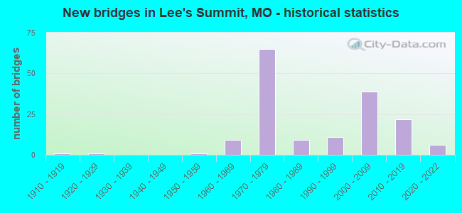
- New bridges - historical statistics
- 11910-1919
- 11920-1929
- 11950-1959
- 91960-1969
- 651970-1979
- 91980-1989
- 111990-1999
- 392000-2009
- 222010-2019
- 62020-2022

- Reconstructed bridges - Historical Statistics
- 11970-1979
- 01980-1989
- 41990-1999
- 62000-2009
- 32010-2019


- Bridge Condition - Deck
- 4.0%Excellent
- 6.0%Very good
- 42.0%Good
- 34.0%Satisfactory
- 12.0%Fair
- 2.0%Poor

- Bridge Condition - Superstructure
- 8.0%Excellent
- 6.0%Very good
- 48.0%Good
- 30.0%Satisfactory
- 6.0%Fair
- 2.0%Poor

- Bridge Condition - Substructure
- 16.0%Excellent
- 10.0%Very good
- 22.0%Good
- 48.0%Satisfactory
- 2.0%Fair
- 2.0%Poor

- Bridge Condition - Channel
- 10.0%Very good
- 28.3%Good
- 43.3%Satisfactory
- 18.3%Fair

- Bridge Condition - Culverts
- 4.2%Excellent
- 8.3%Very good
- 43.8%Good
- 35.4%Satisfactory
- 8.3%Fair
Find on map >> Show street view
Structure Number: 35491, Location: S 31 T 48 N R 31 W (Lat: 38.930556, Lng: -94.388333), Route carried "on" structure: City street 243, Year Built: 2016, Status: Open, Structure Length: 3.77m (12.37ft), Average Daily Traffic: 9,400 (year 2021), Truck Traffic: 10%, Average Future Daily Traffic: 12,220 (year 2041), Design Load: HS 20, Features Intersected: UP RR, Facility Carried by Structure: NE TUDOR RD
Minimum Vertical Clearance: 30+ m (98+ ft), Kilometerpoint: 0.322, Lanes on structure: 4, Owner: Town or Township Highway Agency, Approaching Roadway Width: 25.0m (82.0ft), Skew: 1 degrees, Material/Design: Prestressed concrete, Design/Construction: Tee Beam, Number Of Spans In Main Unit: 1, Length of Maximum Span: 36.6m (120.1ft), Curb or Sidewalk Widths: Left: 2.0m (6.6ft), Right: 3.2m (10.5ft), Curb-To-Curb Width: 16.5m (54.1ft), Out-to-Out Width: 25.1m (82.3ft)
Condition: Deck: Good, Superstructure: Good, Substructure: Excellent, Operating Rating: 89.1 metric tons, Method Used To Determine Operating Rating: Load Factor (LF), Inventory Rating: 32.4 metric tons, Method Used To Determine Inventory Rating: Load Factor (LF), Structural Evaluation: Better than present minimum criteria, Deck Geometry: Meets minimum limits, Approach Roadway Alignment: Equal to present desirable criteria, Designated Inspection Frequency: Every 24 months, Inspection Date: January 2021, Deck Structure Type: Concrete Cast-file-Place, Wearing Surface/Protective System: Wearing Surface: Monolithic Concrete, Deck Protection: Epoxy Coated Reinforcing
Find on map >> Show street view
Structure Number: 35492, Location: S 8 T 47 N R 31 W (Lat: 38.895833, Lng: -94.367778), Route carried "on" structure: City street , Year Built: 2015, Status: Open, Structure Length: 10.09m (33.10ft), Average Daily Traffic: 12,000 (year 2021), Truck Traffic: 10%, Average Future Daily Traffic: 15,600 (year 2041), Design Load: HS 20, Features Intersected: UP RR, Facility Carried by Structure: SE BAILEY RD
Minimum Vertical Clearance: 30+ m (98+ ft), Kilometerpoint: 0.805, Lanes on structure: 2, Owner: Town or Township Highway Agency, Approaching Roadway Width: 9.1m (29.9ft), Skew: 3 degrees, Material/Design: Steel continuous, Design/Construction: Stringer/Multi-beam, Number Of Spans In Main Unit: 2, Length of Maximum Span: 57.0m (187.0ft), Curb or Sidewalk Widths: Left: 0.4m (1.3ft), Right: 3.2m (10.5ft), Curb-To-Curb Width: 9.1m (29.9ft), Out-to-Out Width: 12.7m (41.7ft)
Condition: Deck: Satisfactory, Superstructure: Excellent, Substructure: Excellent, Operating Rating: 50.4 metric tons, Method Used To Determine Operating Rating: Load Factor (LF), Inventory Rating: 30.6 metric tons, Method Used To Determine Inventory Rating: Load Factor (LF), Structural Evaluation: Better than present minimum criteria, Deck Geometry: Meets minimum limits, Approach Roadway Alignment: Better than present minimum criteria, Designated Inspection Frequency: Every 24 months, Inspection Date: January 2021, Deck Structure Type: Concrete Cast-file-Place, Wearing Surface/Protective System: Wearing Surface: Monolithic Concrete, Deck Protection: Epoxy Coated Reinforcing
Find on map >> Show street view
Structure Number: 35493, Location: S 17 T 48 N R 31 W (Lat: 38.971561, Lng: -94.365092), Route carried "on" structure: City street , Year Built: 2014, Status: Open, Structure Length: 0.98m (3.22ft), Average Daily Traffic: 500 (year 2021), Truck Traffic: 10%, Average Future Daily Traffic: 650 (year 2041), Design Load: HS 20, Features Intersected: DRAINAGE DITCH, Facility Carried by Structure: NE MEADOWVIEW DR
Minimum Vertical Clearance: 30+ m (98+ ft), Kilometerpoint: 0.805, Lanes on structure: 2, Owner: Town or Township Highway Agency, Approaching Roadway Width: 11.0m (36.1ft), Material/Design: Concrete, Design/Construction: Culvert, Number Of Spans In Main Unit: 3, Length of Maximum Span: 3.7m (12.1ft)
Condition: Channel: Good, Culverts: Good, Operating Rating: 49.5 metric tons, Method Used To Determine Operating Rating: Load Factor (LF), Inventory Rating: 29.7 metric tons, Method Used To Determine Inventory Rating: Load Factor (LF), Structural Evaluation: Better than present minimum criteria, Waterway Adequacy: Equal to present desirable criteria, Approach Roadway Alignment: Equal to present desirable criteria, Designated Inspection Frequency: Every 24 months, Inspection Date: January 2021
Find on map >> Show street view
Structure Number: 35494, Location: S 17 T 48 N R 31 W (Lat: 38.968306, Lng: -94.365806), Route carried "on" structure: City street , Year Built: 2015, Status: Open, Structure Length: 0.77m (2.53ft), Average Daily Traffic: 900 (year 2021), Truck Traffic: 10%, Average Future Daily Traffic: 1,170 (year 2041), Design Load: HS 20, Features Intersected: MAY BROOK, Facility Carried by Structure: STROTHER RD
Minimum Vertical Clearance: 30+ m (98+ ft), Kilometerpoint: 0.483, Lanes on structure: 2, Owner: City or Municipal Highway Agency, Approaching Roadway Width: 11.6m (38.1ft), Skew: 1 degrees, Material/Design: Concrete, Design/Construction: Culvert, Number Of Spans In Main Unit: 3, Length of Maximum Span: 2.4m (7.9ft)
Condition: Channel: Satisfactory, Culverts: Good, Operating Rating: 87.3 metric tons, Method Used To Determine Operating Rating: Load Factor (LF), Inventory Rating: 52.2 metric tons, Method Used To Determine Inventory Rating: Load Factor (LF), Structural Evaluation: Better than present minimum criteria, Waterway Adequacy: Equal to present desirable criteria, Approach Roadway Alignment: Equal to present desirable criteria, Designated Inspection Frequency: Every 24 months, Inspection Date: January 2021
Find on map >> Show street view
Structure Number: 35495, Location: S 19 T 47 N R 31 W (Lat: 38.879889, Lng: -94.378306), Route carried "on" structure: City street , Year Built: 2016, Status: Open, Structure Length: 0.91m (2.99ft), Average Daily Traffic: 900 (year 2021), Truck Traffic: 10%, Average Future Daily Traffic: 1,170 (year 2041), Design Load: HS 20, Features Intersected: BIG CR, Facility Carried by Structure: JEFFERSON ST
Minimum Vertical Clearance: 30+ m (98+ ft), Kilometerpoint: 0.805, Lanes on structure: 2, Owner: City or Municipal Highway Agency, Approaching Roadway Width: 11.0m (36.1ft), Skew: 1 degrees, Material/Design: Concrete, Design/Construction: Culvert, Number Of Spans In Main Unit: 3, Length of Maximum Span: 2.7m (8.9ft)
Condition: Channel: Very good, Culverts: Excellent, Operating Rating: 68.4 metric tons, Method Used To Determine Operating Rating: Load Factor (LF), Inventory Rating: 40.5 metric tons, Method Used To Determine Inventory Rating: Load Factor (LF), Structural Evaluation: Superior to present desirable criteria, Waterway Adequacy: Equal to present desirable criteria, Approach Roadway Alignment: Equal to present desirable criteria, Designated Inspection Frequency: Every 24 months, Inspection Date: January 2021
Find on map >> Show street view
Structure Number: 35496, Location: S 18 T 47 N R 31 W (Lat: 38.886806, Lng: -94.378000), Route carried "on" structure: City street , Year Built: 2016, Status: Open, Structure Length: 0.89m (2.92ft), Average Daily Traffic: 900 (year 2021), Truck Traffic: 10%, Average Future Daily Traffic: 1,170 (year 2041), Design Load: HS 20, Features Intersected: BR OF BIG CR, Facility Carried by Structure: JEFFERSON ST
Minimum Vertical Clearance: 30+ m (98+ ft), Kilometerpoint: 0.322, Lanes on structure: 2, Owner: City or Municipal Highway Agency, Approaching Roadway Width: 11.0m (36.1ft), Material/Design: Concrete, Design/Construction: Culvert, Number Of Spans In Main Unit: 2, Length of Maximum Span: 2.1m (6.9ft)
Condition: Channel: Very good, Culverts: Very good, Operating Rating: 43.2 metric tons, Method Used To Determine Operating Rating: Load Factor (LF), Inventory Rating: 26.1 metric tons, Method Used To Determine Inventory Rating: Load Factor (LF), Structural Evaluation: Equal to present minimum criteria, Waterway Adequacy: Equal to present desirable criteria, Approach Roadway Alignment: Equal to present desirable criteria, Designated Inspection Frequency: Every 24 months, Inspection Date: January 2021
Find on map >> Show street view
Structure Number: 36135, Location: S 31 T 48 N R 31 W (Lat: 38.930800, Lng: -94.387700), Route carried "on" structure: City street , Year Built: 2016, Status: Open, Structure Length: 0.78m (2.56ft), Average Daily Traffic: 9,400 (year 2021), Truck Traffic: 10%, Average Future Daily Traffic: 12,220 (year 2041), Design Load: HS 20, Features Intersected: DRAINAGE DTCH, Facility Carried by Structure: TUDOR RD
Minimum Vertical Clearance: 30+ m (98+ ft), Kilometerpoint: 10.944, Lanes on structure: 2, Owner: City or Municipal Highway Agency, Approaching Roadway Width: 25.0m (82.0ft), Material/Design: Concrete, Design/Construction: Culvert, Number Of Spans In Main Unit: 3, Length of Maximum Span: 2.4m (7.9ft), Curb or Sidewalk Widths: Left: 3.2m (10.5ft), Right: 2.0m (6.6ft)
Condition: Channel: Good, Culverts: Good, Operating Rating: 54.0 metric tons, Method Used To Determine Operating Rating: Load Factor (LF), Inventory Rating: 32.4 metric tons, Method Used To Determine Inventory Rating: Load Factor (LF), Structural Evaluation: Better than present minimum criteria, Waterway Adequacy: Superior to present desirable criteria, Approach Roadway Alignment: Equal to present desirable criteria, Designated Inspection Frequency: Every 24 months, Inspection Date: January 2021
Find on map >> Show street view
Structure Number: 36136, Location: S 2 T 47 N R 31 W (Lat: 38.920939, Lng: -94.311600), Route carried "on" structure: City street , Year Built: 2019, Status: Open, Structure Length: 1.46m (4.79ft), Average Daily Traffic: 300 (year 2021), Truck Traffic: 1%, Average Future Daily Traffic: 390 (year 2041), Design Load: HS 20, Features Intersected: TRIB PRAIRIELEE LK, Facility Carried by Structure: LEGACY WOOD DR
Minimum Vertical Clearance: 30+ m (98+ ft), Kilometerpoint: 0.000, Lanes on structure: 2, Owner: City or Municipal Highway Agency, Approaching Roadway Width: 13.4m (44.0ft), Material/Design: Concrete, Design/Construction: Culvert, Number Of Spans In Main Unit: 1, Length of Maximum Span: 14.6m (47.9ft)
Condition: Channel: Good, Culverts: Very good, Operating Rating: 54.0 metric tons, Method Used To Determine Operating Rating: Load Factor (LF), Inventory Rating: 32.4 metric tons, Method Used To Determine Inventory Rating: Load Factor (LF), Structural Evaluation: Equal to present desirable criteria, Waterway Adequacy: Better than present minimum criteria, Approach Roadway Alignment: Equal to present desirable criteria, Designated Inspection Frequency: Every 24 months, Inspection Date: January 2021
Find on map >> Show street view
Structure Number: 36137, Location: S 2 T 47 N R 31 W (Lat: 38.919700, Lng: -94.311000), Route carried "on" structure: City street , Year Built: 2019, Status: Open, Structure Length: 1.28m (4.20ft), Average Daily Traffic: 300 (year 2021), Truck Traffic: 1%, Average Future Daily Traffic: 390 (year 2041), Design Load: HS 20, Features Intersected: TRIB PRAIRIELEE LK, Facility Carried by Structure: MARYWOOD LN
Minimum Vertical Clearance: 30+ m (98+ ft), Kilometerpoint: 0.000, Lanes on structure: 2, Owner: City or Municipal Highway Agency, Approaching Roadway Width: 7.3m (24.0ft), Material/Design: Concrete, Design/Construction: Culvert, Number Of Spans In Main Unit: 1, Length of Maximum Span: 12.8m (42.0ft)
Condition: Channel: Good, Culverts: Excellent, Operating Rating: 54.0 metric tons, Method Used To Determine Operating Rating: Load Factor (LF), Inventory Rating: 32.4 metric tons, Method Used To Determine Inventory Rating: Load Factor (LF), Structural Evaluation: Equal to present desirable criteria, Waterway Adequacy: Superior to present desirable criteria, Approach Roadway Alignment: Equal to present minimum criteria, Designated Inspection Frequency: Every 24 months, Inspection Date: January 2021
Find on map >> Show street view
Structure Number: 36657, Location: S 1 T 47 N R 32 W (Lat: 38.925922, Lng: -94.404031), Route carried "on" structure: US 50, Year Built: 2022, Status: Not yet open, Structure Length: 3.84m (12.60ft), Average Daily Traffic: 36,871 (year 2021), Truck Traffic: 7%, Average Future Daily Traffic: 49,776 (year 2041), Features Intersected: CST NW CHIPMAN RD
Minimum Vertical Clearance: 30+ m (98+ ft), Kilometerpoint: 402.633, Lanes on structure: 2, Lanes under structure: 6, Base Highway Network: Yes, Owner: State Highway Agency, Approaching Roadway Width: 12.3m (40.4ft), Skew: 1 degrees, Material/Design: Prestressed concrete continuous, Design/Construction: Tee Beam, Number Of Spans In Main Unit: 2, Length of Maximum Span: 19.9m (65.3ft), Curb-To-Curb Width: 12.3m (40.4ft), Out-to-Out Width: 13.2m (43.3ft)
Condition: Deck: Excellent, Superstructure: Excellent, Substructure: Excellent, Operating Rating: 67.5 metric tons, Method Used To Determine Operating Rating: Load Factor (LF), Inventory Rating: 40.5 metric tons, Method Used To Determine Inventory Rating: Load Factor (LF), Structural Evaluation: Superior to present desirable criteria, Deck Geometry: Better than present minimum criteria, Underclear: Meets minimum limits, Approach Roadway Alignment: Equal to present desirable criteria, Designated Inspection Frequency: Every 24 months, Inspection Date: December 2021, Deck Structure Type: Concrete Cast-file-Place, Wearing Surface/Protective System: Wearing Surface: Monolithic Concrete, Deck Protection: Epoxy Coated Reinforcing
Find on map >> Show street view
Structure Number: 36658, Location: S 1 T 47 N R 32 W (Lat: 38.925942, Lng: -94.404275), Route carried "on" structure: US 50, Year Built: 2022, Status: Not yet open, Structure Length: 3.85m (12.63ft), Average Daily Traffic: 62,855 (year 2021), Truck Traffic: 5%, Average Future Daily Traffic: 84,854 (year 2041), Features Intersected: CST NW CHIPMAN RD
Minimum Vertical Clearance: 30+ m (98+ ft), Kilometerpoint: 18.685, Lanes on structure: 2, Lanes under structure: 6, Base Highway Network: Yes, Owner: State Highway Agency, Approaching Roadway Width: 12.3m (40.4ft), Skew: 1 degrees, Material/Design: Prestressed concrete continuous, Design/Construction: Tee Beam, Number Of Spans In Main Unit: 2, Length of Maximum Span: 19.9m (65.3ft), Curb-To-Curb Width: 12.3m (40.4ft), Out-to-Out Width: 13.2m (43.3ft)
Condition: Deck: Excellent, Superstructure: Excellent, Substructure: Excellent, Operating Rating: 67.5 metric tons, Method Used To Determine Operating Rating: Load Factor (LF), Inventory Rating: 40.5 metric tons, Method Used To Determine Inventory Rating: Load Factor (LF), Structural Evaluation: Superior to present desirable criteria, Deck Geometry: Better than present minimum criteria, Underclear: Meets minimum limits, Approach Roadway Alignment: Equal to present desirable criteria, Designated Inspection Frequency: Every 24 months, Inspection Date: October 2021, Deck Structure Type: Concrete Cast-file-Place, Wearing Surface/Protective System: Wearing Surface: Monolithic Concrete, Deck Protection: Epoxy Coated Reinforcing
Find on map >> Show street view
Structure Number: 12079, Location: S 24 T 50 N R 32 W (Lat: 38.852567, Lng: -94.375653), Route carried "under" structure: State highway 150, Year Built: 1999, Structure Length: 0. m, Average Daily Traffic: 9,556 (year 2021), Truck Traffic: 7%, Features Intersected: MO 150, Facility Carried by Structure: MO 291 N
Minimum Vertical Clearance: 5.41m (17.75ft), Kilometerpoint: 19.359, Lanes on structure: 2, Lanes under structure: 3, Material/Design: Steel continuous, Design/Construction: Stringer/Multi-beam, Length of Maximum Span: 36.0m (118.1ft)
Find on map >> Show street view
Structure Number: 12079, Location: S 24 T 50 N R 32 W (Lat: 38.852567, Lng: -94.375653), Route carried "under" structure: State highway 150, Year Built: 1999, Structure Length: 0. m, Average Daily Traffic: 10,003 (year 2021), Truck Traffic: 9%, Features Intersected: MO 150, Facility Carried by Structure: MO 291 N
Minimum Vertical Clearance: 5.41m (17.75ft), Kilometerpoint: 21.937, Lanes on structure: 2, Lanes under structure: 3, Material/Design: Steel continuous, Design/Construction: Stringer/Multi-beam, Length of Maximum Span: 36.0m (118.1ft)
Find on map >> Show street view
Structure Number: 1208, Location: S 24 T 50 N R 32 W (Lat: 38.852572, Lng: -94.375967), Route carried "under" structure: State highway 150, Year Built: 1999, Structure Length: 0. m, Average Daily Traffic: 10,003 (year 2021), Truck Traffic: 9%, Features Intersected: MO 150, Facility Carried by Structure: MO 291 S
Minimum Vertical Clearance: 5.36m (17.59ft), Kilometerpoint: 21.910, Lanes on structure: 2, Lanes under structure: 3, Material/Design: Steel continuous, Design/Construction: Stringer/Multi-beam, Length of Maximum Span: 36.0m (118.1ft)
Find on map >> Show street view
Structure Number: 1208, Location: S 24 T 50 N R 32 W (Lat: 38.852572, Lng: -94.375967), Route carried "under" structure: State highway 150, Year Built: 1999, Structure Length: 0. m, Average Daily Traffic: 9,556 (year 2021), Truck Traffic: 7%, Features Intersected: MO 150, Facility Carried by Structure: MO 291 S
Minimum Vertical Clearance: 5.41m (17.75ft), Kilometerpoint: 19.386, Lanes on structure: 2, Lanes under structure: 3, Material/Design: Steel continuous, Design/Construction: Stringer/Multi-beam, Length of Maximum Span: 36.0m (118.1ft)
Find on map >> Show street view
Structure Number: 1303, Location: S 6 T 47 N R 31 W (Lat: 38.911225, Lng: -94.394011), Route carried "under" structure: City street , Year Built: 1967, Structure Length: 0. m, Average Daily Traffic: 8,072 (year 2021), Truck Traffic: 2%, Features Intersected: CST SW 3RD ST, Facility Carried by Structure: US 50 E
Minimum Vertical Clearance: 4.85m (15.91ft), Kilometerpoint: 4.923, Lanes on structure: 2, Lanes under structure: 5, Material/Design: Steel continuous, Design/Construction: Stringer/Multi-beam, Length of Maximum Span: 22.9m (75.1ft)
Find on map >> Show street view
Structure Number: 1304, Location: S 6 T 47 N R 31 W (Lat: 38.911231, Lng: -94.393761), Route carried "under" structure: City street , Year Built: 1967, Structure Length: 0. m, Average Daily Traffic: 8,823 (year 2021), Truck Traffic: 2%, Features Intersected: CST SW 3RD ST, Facility Carried by Structure: US 50 W
Minimum Vertical Clearance: 4.62m (15.16ft), Kilometerpoint: 4.944, Lanes on structure: 2, Lanes under structure: 5, Material/Design: Steel continuous, Design/Construction: Stringer/Multi-beam, Length of Maximum Span: 22.9m (75.1ft)
Find on map >> Show street view
Structure Number: 1443, Location: S 8 T 47 N R 31 W (Lat: 38.903228, Lng: -94.363314), Route carried "under" structure: US 50, Year Built: 1967, Structure Length: 0. m, Average Daily Traffic: 38,753 (year 2021), Truck Traffic: 5%, Features Intersected: US 50, Facility Carried by Structure: MO 291 S
Minimum Vertical Clearance: 4.57m (14.99ft), Kilometerpoint: 23.569, Lanes on structure: 5, Lanes under structure: 2, Material/Design: Concrete continuous, Design/Construction: Slab, Length of Maximum Span: 13.4m (44.0ft)
Find on map >> Show street view
Structure Number: 1443, Location: S 8 T 47 N R 31 W (Lat: 38.903228, Lng: -94.363314), Route carried "under" structure: US 50, Year Built: 1967, Structure Length: 0. m, Average Daily Traffic: 28,551 (year 2021), Truck Traffic: 11%, Features Intersected: US 50, Facility Carried by Structure: MO 291 S
Minimum Vertical Clearance: 4.60m (15.09ft), Kilometerpoint: 397.827, Lanes on structure: 5, Lanes under structure: 2, Material/Design: Concrete continuous, Design/Construction: Slab, Length of Maximum Span: 13.4m (44.0ft)
Find on map >> Show street view
Structure Number: 1797, Location: S 36 T 48 N R 32 W (Lat: 38.939356, Lng: -94.394478), Route carried "under" structure: City street , Year Built: 1979, Structure Length: 0. m, Average Daily Traffic: 1,168 (year 2021), Truck Traffic: 5%, Features Intersected: CST NW MAIN ST, Facility Carried by Structure: IS 470 E
Minimum Vertical Clearance: 5.54m (18.18ft), Kilometerpoint: 0.682, Lanes on structure: 3, Lanes under structure: 2, Material/Design: Steel continuous, Design/Construction: Stringer/Multi-beam, Length of Maximum Span: 17.7m (58.1ft)
Find on map >> Show street view
Structure Number: 1798, Location: S 36 T 48 N R 32 W (Lat: 38.939556, Lng: -94.394675), Route carried "under" structure: City street , Year Built: 1979, Structure Length: 0. m, Average Daily Traffic: 1,168 (year 2021), Truck Traffic: 5%, Features Intersected: CST NW MAIN ST, Facility Carried by Structure: IS 470 W
Minimum Vertical Clearance: 5.54m (18.18ft), Kilometerpoint: 0.655, Lanes on structure: 3, Lanes under structure: 2, Material/Design: Steel continuous, Design/Construction: Stringer/Multi-beam, Length of Maximum Span: 17.7m (58.1ft)
Find on map >> Show street view
Structure Number: 1799, Location: S 30 T 48 N R 31 W (Lat: 38.944508, Lng: -94.378236), Route carried "under" structure: Interstate 470, Year Built: 1979, Structure Length: 0. m, Average Daily Traffic: 38,332 (year 2021), Truck Traffic: 6%, Features Intersected: IS 470, Facility Carried by Structure: NE DOUGLAS ST S
Minimum Vertical Clearance: 5.72m (18.77ft), Kilometerpoint: 14.941, Lanes on structure: 6, Lanes under structure: 3, Material/Design: Steel continuous, Design/Construction: Stringer/Multi-beam, Length of Maximum Span: 26.8m (87.9ft)
Find on map >> Show street view
Structure Number: 1799, Location: S 30 T 48 N R 31 W (Lat: 38.944508, Lng: -94.378236), Route carried "under" structure: Interstate 470, Year Built: 1979, Structure Length: 0. m, Average Daily Traffic: 34,532 (year 2021), Truck Traffic: 6%, Features Intersected: IS 470, Facility Carried by Structure: NE DOUGLAS ST S
Minimum Vertical Clearance: 5.06m (16.60ft), Kilometerpoint: 12.492, Lanes on structure: 6, Lanes under structure: 3, Material/Design: Steel continuous, Design/Construction: Stringer/Multi-beam, Length of Maximum Span: 26.8m (87.9ft)
Find on map >> Show street view
Structure Number: 18, Location: S 29 T 48 N R 31 W (Lat: 38.946253, Lng: -94.364519), Route carried "under" structure: Interstate 470, Year Built: 1979, Structure Length: 0. m, Average Daily Traffic: 36,595 (year 2021), Truck Traffic: 6%, Features Intersected: IS 470, Facility Carried by Structure: NE COLBERN RD E
Minimum Vertical Clearance: 5.13m (16.83ft), Kilometerpoint: 16.198, Lanes on structure: 5, Lanes under structure: 2, Material/Design: Steel continuous, Design/Construction: Stringer/Multi-beam, Length of Maximum Span: 35.1m (115.2ft)
Find on map >> Show street view
Structure Number: 18, Location: S 29 T 48 N R 31 W (Lat: 38.946253, Lng: -94.364519), Route carried "under" structure: Interstate 470, Year Built: 1979, Structure Length: 0. m, Average Daily Traffic: 34,532 (year 2021), Truck Traffic: 6%, Features Intersected: IS 470, Facility Carried by Structure: NE COLBERN RD E
Minimum Vertical Clearance: 5.11m (16.77ft), Kilometerpoint: 11.280, Lanes on structure: 5, Lanes under structure: 2, Material/Design: Steel continuous, Design/Construction: Stringer/Multi-beam, Length of Maximum Span: 35.1m (115.2ft)
Find on map >> Show street view
Structure Number: 1801, Location: S 29 T 48 N R 31 W (Lat: 38.946178, Lng: -94.361208), Route carried "under" structure: State highway 291, Year Built: 1980, Structure Length: 0. m, Average Daily Traffic: 11,794 (year 2021), Truck Traffic: 3%, Features Intersected: MO 291, Facility Carried by Structure: NE COLBERN RD E
Minimum Vertical Clearance: 5.03m (16.50ft), Kilometerpoint: 33.400, Lanes on structure: 5, Lanes under structure: 2, Material/Design: Steel continuous, Design/Construction: Stringer/Multi-beam, Length of Maximum Span: 26.5m (86.9ft)
Find on map >> Show street view
Structure Number: 1801, Location: S 29 T 48 N R 31 W (Lat: 38.946178, Lng: -94.361208), Route carried "under" structure: State highway 291, Year Built: 1980, Structure Length: 0. m, Average Daily Traffic: 5,769 (year 2021), Truck Traffic: 3%, Features Intersected: MO 291, Facility Carried by Structure: NE COLBERN RD E
Minimum Vertical Clearance: 5.13m (16.83ft), Kilometerpoint: 46.042, Lanes on structure: 5, Lanes under structure: 2, Material/Design: Steel continuous, Design/Construction: Stringer/Multi-beam, Length of Maximum Span: 26.5m (86.9ft)
Find on map >> Show street view
Structure Number: 1802, Location: S 29 T 48 N R 31 W (Lat: 38.949081, Lng: -94.361394), Route carried "under" structure: Interstate 470, Year Built: 1979, Structure Length: 0. m, Average Daily Traffic: 36,595 (year 2021), Truck Traffic: 6%, Features Intersected: IS 470, Facility Carried by Structure: MO 291 S
Minimum Vertical Clearance: 5.11m (16.77ft), Kilometerpoint: 16.594, Lanes on structure: 2, Lanes under structure: 2, Material/Design: Steel continuous, Design/Construction: Stringer/Multi-beam, Length of Maximum Span: 39.9m (130.9ft)
Find on map >> Show street view
Structure Number: 1803, Location: S 8 T 48 N R 31 W (Lat: 38.982511, Lng: -94.356181), Route carried "under" structure: Interstate 470, Year Built: 1979, Structure Length: 0. m, Average Daily Traffic: 40,248 (year 2021), Truck Traffic: 6%, Features Intersected: IS 470, Facility Carried by Structure: NE WOODS CHAPEL RD
Minimum Vertical Clearance: 5.03m (16.50ft), Kilometerpoint: 20.337, Lanes on structure: 6, Lanes under structure: 2, Material/Design: Steel continuous, Design/Construction: Stringer/Multi-beam, Length of Maximum Span: 26.5m (86.9ft)
Find on map >> Show street view
Structure Number: 1803, Location: S 8 T 48 N R 31 W (Lat: 38.982511, Lng: -94.356181), Route carried "under" structure: Interstate 470, Year Built: 1979, Structure Length: 0. m, Average Daily Traffic: 34,814 (year 2021), Truck Traffic: 6%, Features Intersected: IS 470, Facility Carried by Structure: NE WOODS CHAPEL RD
Minimum Vertical Clearance: 5.44m (17.85ft), Kilometerpoint: 7.157, Lanes on structure: 6, Lanes under structure: 2, Material/Design: Steel continuous, Design/Construction: Stringer/Multi-beam, Length of Maximum Span: 26.5m (86.9ft)
Find on map >> Show street view
Structure Number: 1804, Location: S 5 T 48 N R 31 W (Lat: 39.004364, Lng: -94.357003), Route carried "under" structure: City street , Year Built: 1979, Structure Length: 0. m, Average Daily Traffic: 4,000 (year 2021), Truck Traffic: 10%, Features Intersected: CST NE LAKEWOOD BLVD, Facility Carried by Structure: IS 470 W
Minimum Vertical Clearance: 4.70m (15.42ft), Kilometerpoint: 2.168, Lanes on structure: 2, Lanes under structure: 4, Material/Design: Concrete continuous, Design/Construction: Slab, Length of Maximum Span: 18.3m (60.0ft)
Find on map >> Show street view
Structure Number: 1831, Location: S 33 T 48 N R 32 W (Lat: 38.936208, Lng: -94.447925), Route carried "under" structure: City street , Year Built: 1976, Structure Length: 0. m, Average Daily Traffic: 9,421 (year 2021), Truck Traffic: 2%, Features Intersected: CST VIEW HIGH DR, Facility Carried by Structure: IS 470 E
Minimum Vertical Clearance: 4.47m (14.67ft), Kilometerpoint: 2.134, Lanes on structure: 6, Lanes under structure: 4, Material/Design: Concrete continuous, Design/Construction: Slab, Length of Maximum Span: 18.0m (59.1ft)
Find on map >> Show street view
Structure Number: 2113, Location: S 36 T 48 N R 32 W (Lat: 38.934217, Lng: -94.406283), Route carried "under" structure: State highway 350, Year Built: 1976, Structure Length: 0. m, Average Daily Traffic: 10,702 (year 2021), Truck Traffic: 6%, Features Intersected: MO 350, Facility Carried by Structure: IS 470 E
Minimum Vertical Clearance: 5.11m (16.77ft), Kilometerpoint: 13.762, Lanes on structure: 3, Lanes under structure: 3, Material/Design: Steel continuous, Design/Construction: Stringer/Multi-beam, Length of Maximum Span: 23.8m (78.1ft)
Find on map >> Show street view
Structure Number: 2113, Location: S 36 T 48 N R 32 W (Lat: 38.934217, Lng: -94.406283), Route carried "under" structure: US 50, Year Built: 1976, Structure Length: 0. m, Average Daily Traffic: 66,942 (year 2021), Truck Traffic: 11%, Features Intersected: US 50, Facility Carried by Structure: IS 470 E
Minimum Vertical Clearance: 5.21m (17.09ft), Kilometerpoint: 403.592, Lanes on structure: 3, Lanes under structure: 3, Material/Design: Steel continuous, Design/Construction: Stringer/Multi-beam, Length of Maximum Span: 23.8m (78.1ft)
Find on map >> Show street view
Structure Number: 2114, Location: S 36 T 48 N R 32 W (Lat: 38.934439, Lng: -94.406458), Route carried "under" structure: US 50, Year Built: 1976, Structure Length: 0. m, Average Daily Traffic: 66,942 (year 2021), Truck Traffic: 11%, Features Intersected: US 50, Facility Carried by Structure: IS 470 W
Minimum Vertical Clearance: 5.03m (16.50ft), Kilometerpoint: 403.619, Lanes on structure: 3, Lanes under structure: 3, Material/Design: Steel continuous, Design/Construction: Stringer/Multi-beam, Length of Maximum Span: 23.8m (78.1ft)
Find on map >> Show street view
Structure Number: 2114, Location: S 36 T 48 N R 32 W (Lat: 38.934439, Lng: -94.406458), Route carried "under" structure: State highway 350, Year Built: 1976, Structure Length: 0. m, Average Daily Traffic: 10,702 (year 2021), Truck Traffic: 6%, Features Intersected: MO 350, Facility Carried by Structure: IS 470 W
Minimum Vertical Clearance: 4.95m (16.24ft), Kilometerpoint: 13.731, Lanes on structure: 3, Lanes under structure: 3, Material/Design: Steel continuous, Design/Construction: Stringer/Multi-beam, Length of Maximum Span: 23.8m (78.1ft)
Find on map >> Show street view
Structure Number: 2115, Location: S 25 T 48 N R 32 W (Lat: 38.944228, Lng: -94.408981), Route carried "under" structure: State highway 350, Year Built: 1974, Structure Length: 0. m, Average Daily Traffic: 14,711 (year 2021), Truck Traffic: 6%, Features Intersected: MO 350, Facility Carried by Structure: BANNISTER RD W
Minimum Vertical Clearance: 5.00m (16.40ft), Kilometerpoint: 12.620, Lanes on structure: 6, Lanes under structure: 3, Material/Design: Steel continuous, Design/Construction: Stringer/Multi-beam, Length of Maximum Span: 23.5m (77.1ft)
Find on map >> Show street view
Structure Number: 2115, Location: S 25 T 48 N R 32 W (Lat: 38.944228, Lng: -94.408981), Route carried "under" structure: State highway 350, Year Built: 1974, Structure Length: 0. m, Average Daily Traffic: 9,309 (year 2021), Truck Traffic: 7%, Features Intersected: MO 350, Facility Carried by Structure: BANNISTER RD W
Minimum Vertical Clearance: 5.00m (16.40ft), Kilometerpoint: 1.180, Lanes on structure: 6, Lanes under structure: 3, Material/Design: Steel continuous, Design/Construction: Stringer/Multi-beam, Length of Maximum Span: 23.5m (77.1ft)
Find on map >> Show street view
Structure Number: 2116, Location: S 1 T 47 N R 32 W (Lat: 38.918869, Lng: -94.401267), Route carried "under" structure: City street , Year Built: 1974, Structure Length: 0. m, Average Daily Traffic: 3,248 (year 2021), Truck Traffic: 5%, Features Intersected: CST NW BLUE PKWY, Facility Carried by Structure: NW O BRIEN RD E
Minimum Vertical Clearance: 6.10m (20.01ft), Kilometerpoint: 4.390, Lanes on structure: 2, Lanes under structure: 2, Material/Design: Steel continuous, Design/Construction: Stringer/Multi-beam, Length of Maximum Span: 20.7m (67.9ft)
Find on map >> Show street view
Structure Number: 2116, Location: S 1 T 47 N R 32 W (Lat: 38.918869, Lng: -94.401267), Route carried "under" structure: US 50, Year Built: 1974, Structure Length: 0. m, Average Daily Traffic: 36,871 (year 2021), Truck Traffic: 7%, Features Intersected: US 50, Facility Carried by Structure: NW O BRIEN RD E
Minimum Vertical Clearance: 5.89m (19.32ft), Kilometerpoint: 401.836, Lanes on structure: 2, Lanes under structure: 2, Material/Design: Steel continuous, Design/Construction: Stringer/Multi-beam, Length of Maximum Span: 20.7m (67.9ft)
Find on map >> Show street view
Structure Number: 2116, Location: S 1 T 47 N R 32 W (Lat: 38.918869, Lng: -94.401267), Route carried "under" structure: US 50, Year Built: 1974, Structure Length: 0. m, Average Daily Traffic: 34,765 (year 2021), Truck Traffic: 8%, Features Intersected: US 50, Facility Carried by Structure: NW O BRIEN RD E
Minimum Vertical Clearance: 5.38m (17.65ft), Kilometerpoint: 19.533, Lanes on structure: 2, Lanes under structure: 2, Material/Design: Steel continuous, Design/Construction: Stringer/Multi-beam, Length of Maximum Span: 20.7m (67.9ft)
Find on map >> Show street view
Structure Number: 2147, Location: S 1 T 47 N R 32 W (Lat: 38.925942, Lng: -94.404278), Route carried "under" structure: City street , Year Built: 1975, Structure Length: 0. m, Average Daily Traffic: 9,854 (year 2021), Truck Traffic: 5%, Features Intersected: CST NW CHIPMAN RD, Facility Carried by Structure: US 50 E
Minimum Vertical Clearance: 5.31m (17.42ft), Kilometerpoint: 1.967, Lanes on structure: 2, Lanes under structure: 3, Material/Design: Concrete continuous, Design/Construction: Slab, Length of Maximum Span: 15.8m (51.8ft)
Find on map >> Show street view
Structure Number: 2147, Location: S 1 T 47 N R 32 W (Lat: 38.925942, Lng: -94.404278), Route carried "under" structure: City street , Year Built: 1975, Structure Length: 0. m, Average Daily Traffic: 8,285 (year 2021), Truck Traffic: 5%, Features Intersected: CST NW CHIPMAN RD, Facility Carried by Structure: US 50 E
Minimum Vertical Clearance: 5.31m (17.42ft), Kilometerpoint: 4.010, Lanes on structure: 2, Lanes under structure: 3, Material/Design: Concrete continuous, Design/Construction: Slab, Length of Maximum Span: 15.8m (51.8ft)
Find on map >> Show street view
Structure Number: 2172, Location: S 36 T 48 N R 32 W (Lat: 38.935689, Lng: -94.403297), Route carried "under" structure: Interstate 470, Year Built: 1979, Structure Length: 0. m, Average Daily Traffic: 36,571 (year 2021), Truck Traffic: 6%, Features Intersected: IS 470, Facility Carried by Structure: NW BLUE PKWY N
Minimum Vertical Clearance: 5.21m (17.09ft), Kilometerpoint: 14.895, Lanes on structure: 3, Lanes under structure: 2, Material/Design: Steel continuous, Design/Construction: Stringer/Multi-beam, Length of Maximum Span: 32.6m (107.0ft)
Find on map >> Show street view
Structure Number: 2172, Location: S 36 T 48 N R 32 W (Lat: 38.935689, Lng: -94.403297), Route carried "under" structure: Interstate 470, Year Built: 1979, Structure Length: 0. m, Average Daily Traffic: 38,332 (year 2021), Truck Traffic: 6%, Features Intersected: IS 470, Facility Carried by Structure: NW BLUE PKWY N
Minimum Vertical Clearance: 5.05m (16.57ft), Kilometerpoint: 12.548, Lanes on structure: 3, Lanes under structure: 2, Material/Design: Steel continuous, Design/Construction: Stringer/Multi-beam, Length of Maximum Span: 32.6m (107.0ft)
Find on map >> Show street view
Structure Number: 2172, Location: S 36 T 48 N R 32 W (Lat: 38.935689, Lng: -94.403297), Route carried "under" structure: Ramp State highway , Year Built: 1979, Structure Length: 0. m, Average Daily Traffic: 1,660 (year 2021), Truck Traffic: 5%, Features Intersected: RP IS470W TO MO350W, Facility Carried by Structure: NW BLUE PKWY N
Minimum Vertical Clearance: 6.45m (21.16ft), Kilometerpoint: 0.454, Lanes on structure: 3, Lanes under structure: 1, Material/Design: Steel continuous, Design/Construction: Stringer/Multi-beam, Length of Maximum Span: 32.6m (107.0ft)
Find on map >> Show street view
Structure Number: 2172, Location: S 36 T 48 N R 32 W (Lat: 38.935689, Lng: -94.403297), Route carried "under" structure: Ramp State highway , Year Built: 1979, Structure Length: 0. m, Average Daily Traffic: 7,642 (year 2021), Truck Traffic: 5%, Features Intersected: RP US50W TO IS470E, Facility Carried by Structure: NW BLUE PKWY N
Minimum Vertical Clearance: 5.30m (17.39ft), Kilometerpoint: 0.589, Lanes on structure: 3, Lanes under structure: 1, Material/Design: Steel continuous, Design/Construction: Stringer/Multi-beam, Length of Maximum Span: 32.6m (107.0ft)
Find on map >> Show street view
Structure Number: 2173, Location: S 36 T 48 N R 32 W (Lat: 38.935600, Lng: -94.403444), Route carried "under" structure: Interstate 470, Year Built: 1979, Structure Length: 0. m, Average Daily Traffic: 38,332 (year 2021), Truck Traffic: 6%, Features Intersected: IS 470, Facility Carried by Structure: NW BLUE PKWY S
Minimum Vertical Clearance: 4.98m (16.34ft), Kilometerpoint: 12.534, Lanes on structure: 3, Lanes under structure: 2, Material/Design: Steel continuous, Design/Construction: Stringer/Multi-beam, Length of Maximum Span: 37.8m (124.0ft)
Find on map >> Show street view
Structure Number: 2173, Location: S 36 T 48 N R 32 W (Lat: 38.935600, Lng: -94.403444), Route carried "under" structure: Interstate 470, Year Built: 1979, Structure Length: 0. m, Average Daily Traffic: 36,571 (year 2021), Truck Traffic: 6%, Features Intersected: IS 470, Facility Carried by Structure: NW BLUE PKWY S
Minimum Vertical Clearance: 4.93m (16.17ft), Kilometerpoint: 14.909, Lanes on structure: 3, Lanes under structure: 2, Material/Design: Steel continuous, Design/Construction: Stringer/Multi-beam, Length of Maximum Span: 37.8m (124.0ft)
Find on map >> Show street view
Structure Number: 2173, Location: S 36 T 48 N R 32 W (Lat: 38.935600, Lng: -94.403444), Route carried "under" structure: Ramp State highway , Year Built: 1979, Structure Length: 0. m, Average Daily Traffic: 1,660 (year 2021), Truck Traffic: 5%, Features Intersected: RP IS470W TO MO350W, Facility Carried by Structure: NW BLUE PKWY S
Minimum Vertical Clearance: 4.95m (16.24ft), Kilometerpoint: 0.468, Lanes on structure: 3, Lanes under structure: 1, Material/Design: Steel continuous, Design/Construction: Stringer/Multi-beam, Length of Maximum Span: 37.8m (124.0ft)
Find on map >> Show street view
Structure Number: 2173, Location: S 36 T 48 N R 32 W (Lat: 38.935600, Lng: -94.403444), Route carried "under" structure: Ramp State highway , Year Built: 1979, Structure Length: 0. m, Average Daily Traffic: 7,642 (year 2021), Truck Traffic: 5%, Features Intersected: RP US50W TO IS470E, Facility Carried by Structure: NW BLUE PKWY S
Minimum Vertical Clearance: 5.08m (16.67ft), Kilometerpoint: 0.573, Lanes on structure: 3, Lanes under structure: 1, Material/Design: Steel continuous, Design/Construction: Stringer/Multi-beam, Length of Maximum Span: 37.8m (124.0ft)
Find on map >> Show street view
Structure Number: 276, Location: S 1 T 47 N R 32 W (Lat: 38.925922, Lng: -94.404033), Route carried "under" structure: City street , Year Built: 1975, Structure Length: 0. m, Average Daily Traffic: 8,285 (year 2021), Truck Traffic: 5%, Features Intersected: CST NW CHIPMAN RD, Facility Carried by Structure: US 50 W
Minimum Vertical Clearance: 4.62m (15.16ft), Kilometerpoint: 4.031, Lanes on structure: 2, Lanes under structure: 3, Material/Design: Concrete continuous, Design/Construction: Slab, Length of Maximum Span: 15.8m (51.8ft)
Find on map >> Show street view
Structure Number: 276, Location: S 1 T 47 N R 32 W (Lat: 38.925922, Lng: -94.404033), Route carried "under" structure: City street , Year Built: 1975, Structure Length: 0. m, Average Daily Traffic: 9,854 (year 2021), Truck Traffic: 5%, Features Intersected: CST NW CHIPMAN RD, Facility Carried by Structure: US 50 W
Minimum Vertical Clearance: 4.62m (15.16ft), Kilometerpoint: 1.946, Lanes on structure: 2, Lanes under structure: 3, Material/Design: Concrete continuous, Design/Construction: Slab, Length of Maximum Span: 15.8m (51.8ft)
Find on map >> Show street view
Structure Number: 2868, Location: S 5 T 48 N R 31 W (Lat: 39.004358, Lng: -94.356647), Route carried "under" structure: City street , Year Built: 1979, Structure Length: 0. m, Average Daily Traffic: 1,494 (year 2021), Truck Traffic: 8%, Features Intersected: CST NE BOWLIN RD, Facility Carried by Structure: IS 470 E
Minimum Vertical Clearance: 4.70m (15.42ft), Kilometerpoint: 0.000, Lanes on structure: 2, Lanes under structure: 4, Material/Design: Concrete continuous, Design/Construction: Slab, Length of Maximum Span: 18.3m (60.0ft)
Find on map >> Show street view
Structure Number: 31998, Location: S 35 T 48 N R 32 W (Lat: 38.933933, Lng: -94.412197), Route carried "under" structure: Interstate 470, Year Built: 2007, Structure Length: 0. m, Average Daily Traffic: 45,995 (year 2021), Truck Traffic: 12%, Features Intersected: IS 470, Facility Carried by Structure: NW PRYOR RD S
Minimum Vertical Clearance: 5.59m (18.34ft), Kilometerpoint: 11.726, Lanes on structure: 7, Lanes under structure: 3, Material/Design: Prestressed concrete continuous, Design/Construction: Tee Beam, Length of Maximum Span: 33.5m (109.9ft)
Find on map >> Show street view
Structure Number: 31998, Location: S 35 T 48 N R 32 W (Lat: 38.933933, Lng: -94.412197), Route carried "under" structure: Interstate 470, Year Built: 2007, Structure Length: 0. m, Average Daily Traffic: 47,068 (year 2021), Truck Traffic: 12%, Features Intersected: IS 470, Facility Carried by Structure: NW PRYOR RD S
Minimum Vertical Clearance: 5.08m (16.67ft), Kilometerpoint: 15.707, Lanes on structure: 7, Lanes under structure: 3, Material/Design: Prestressed concrete continuous, Design/Construction: Tee Beam, Length of Maximum Span: 33.5m (109.9ft)
Find on map >> Show street view
Structure Number: 31998, Location: S 35 T 48 N R 32 W (Lat: 38.933933, Lng: -94.412197), Route carried "under" structure: US 50, Year Built: 2007, Structure Length: 0. m, Average Daily Traffic: 17,687 (year 2021), Truck Traffic: 5%, Features Intersected: US 50, Facility Carried by Structure: NW PRYOR RD S
Minimum Vertical Clearance: 6.02m (19.75ft), Kilometerpoint: 17.471, Lanes on structure: 7, Lanes under structure: 1, Material/Design: Prestressed concrete continuous, Design/Construction: Tee Beam, Length of Maximum Span: 33.5m (109.9ft)
Find on map >> Show street view
Structure Number: 32467, Location: S 36 T 48 N R 32 W (Lat: 38.936078, Lng: -94.406928), Route carried "under" structure: Ramp State highway , Year Built: 2009, Structure Length: 0. m, Average Daily Traffic: 1,660 (year 2021), Truck Traffic: 5%, Features Intersected: RP IS470W TO MO350W, Facility Carried by Structure: RP IS470W TO PRYOR
Minimum Vertical Clearance: 5.36m (17.59ft), Kilometerpoint: 0.645, Lanes on structure: 2, Lanes under structure: 1, Material/Design: Prestressed concrete continuous, Design/Construction: Tee Beam, Length of Maximum Span: 39.6m (129.9ft)
Find on map >> Show street view
Structure Number: 32467, Location: S 36 T 48 N R 32 W (Lat: 38.936078, Lng: -94.406928), Route carried "under" structure: Ramp State highway , Year Built: 2009, Structure Length: 0. m, Average Daily Traffic: 635 (year 2021), Truck Traffic: 6%, Features Intersected: RP MO350E TO IS470W, Facility Carried by Structure: RP IS470W TO PRYOR
Minimum Vertical Clearance: 5.03m (16.50ft), Kilometerpoint: 0.224, Lanes on structure: 2, Lanes under structure: 1, Material/Design: Prestressed concrete continuous, Design/Construction: Tee Beam, Length of Maximum Span: 39.6m (129.9ft)
Find on map >> Show street view
Structure Number: 32467, Location: S 36 T 48 N R 32 W (Lat: 38.936078, Lng: -94.406928), Route carried "under" structure: State highway 350, Year Built: 2009, Structure Length: 0. m, Average Daily Traffic: 9,309 (year 2021), Truck Traffic: 7%, Features Intersected: MO 350, Facility Carried by Structure: RP IS470W TO PRYOR
Minimum Vertical Clearance: 6.81m (22.34ft), Kilometerpoint: 0.259, Lanes on structure: 2, Lanes under structure: 2, Material/Design: Prestressed concrete continuous, Design/Construction: Tee Beam, Length of Maximum Span: 39.6m (129.9ft)
Find on map >> Show street view
Structure Number: 32467, Location: S 36 T 48 N R 32 W (Lat: 38.936078, Lng: -94.406928), Route carried "under" structure: State highway 350, Year Built: 2009, Structure Length: 0. m, Average Daily Traffic: 10,702 (year 2021), Truck Traffic: 6%, Features Intersected: MO 350, Facility Carried by Structure: RP IS470W TO PRYOR
Minimum Vertical Clearance: 6.60m (21.65ft), Kilometerpoint: 13.544, Lanes on structure: 2, Lanes under structure: 2, Material/Design: Prestressed concrete continuous, Design/Construction: Tee Beam, Length of Maximum Span: 39.6m (129.9ft)
Find on map >> Show street view
Structure Number: 32469, Location: S 36 T 48 N R 32 W (Lat: 38.932642, Lng: -94.405744), Route carried "under" structure: Ramp State highway , Year Built: 2009, Structure Length: 0. m, Average Daily Traffic: 7,642 (year 2021), Truck Traffic: 5%, Features Intersected: RP US50W TO IS470E, Facility Carried by Structure: RP PRYOR RD TO IS4
Minimum Vertical Clearance: 7.24m (23.75ft), Kilometerpoint: 0.309, Lanes on structure: 2, Lanes under structure: 1, Material/Design: Prestressed concrete continuous, Design/Construction: Tee Beam, Length of Maximum Span: 41.1m (134.8ft)
Find on map >> Show street view
Structure Number: 32469, Location: S 36 T 48 N R 32 W (Lat: 38.932642, Lng: -94.405744), Route carried "under" structure: US 50, Year Built: 2009, Structure Length: 0. m, Average Daily Traffic: 66,942 (year 2021), Truck Traffic: 11%, Features Intersected: US 50, Facility Carried by Structure: RP PRYOR RD TO IS4
Minimum Vertical Clearance: 7.67m (25.16ft), Kilometerpoint: 403.410, Lanes on structure: 2, Lanes under structure: 2, Material/Design: Prestressed concrete continuous, Design/Construction: Tee Beam, Length of Maximum Span: 41.1m (134.8ft)
Find on map >> Show street view
Structure Number: 32469, Location: S 36 T 48 N R 32 W (Lat: 38.932642, Lng: -94.405744), Route carried "under" structure: US 50, Year Built: 2009, Structure Length: 0. m, Average Daily Traffic: 17,687 (year 2021), Truck Traffic: 5%, Features Intersected: US 50, Facility Carried by Structure: RP PRYOR RD TO IS4
Minimum Vertical Clearance: 7.67m (25.16ft), Kilometerpoint: 17.917, Lanes on structure: 2, Lanes under structure: 1, Material/Design: Prestressed concrete continuous, Design/Construction: Tee Beam, Length of Maximum Span: 41.1m (134.8ft)
Find on map >> Show street view
Structure Number: 32469, Location: S 36 T 48 N R 32 W (Lat: 38.932642, Lng: -94.405744), Route carried "under" structure: State highway 350, Year Built: 2009, Structure Length: 0. m, Average Daily Traffic: 10,702 (year 2021), Truck Traffic: 6%, Features Intersected: MO 350, Facility Carried by Structure: RP PRYOR RD TO IS4
Minimum Vertical Clearance: 7.67m (25.16ft), Kilometerpoint: 13.940, Lanes on structure: 2, Lanes under structure: 2, Material/Design: Prestressed concrete continuous, Design/Construction: Tee Beam, Length of Maximum Span: 41.1m (134.8ft)
Find on map >> Show street view
Structure Number: 3247, Location: S 17 T 48 N R 31 W (Lat: 38.967981, Lng: -94.358122), Route carried "under" structure: City street , Year Built: 2008, Structure Length: 0. m, Average Daily Traffic: 2,331 (year 2021), Truck Traffic: 5%, Features Intersected: CST NE STROTHER RD, Facility Carried by Structure: IS 470 E
Minimum Vertical Clearance: 5.13m (16.83ft), Kilometerpoint: 2.425, Lanes on structure: 2, Lanes under structure: 3, Material/Design: Prestressed concrete continuous, Design/Construction: Tee Beam, Length of Maximum Span: 33.2m (108.9ft)
Find on map >> Show street view
Structure Number: 3247, Location: S 17 T 48 N R 31 W (Lat: 38.967981, Lng: -94.358122), Route carried "under" structure: City street , Year Built: 2008, Structure Length: 0. m, Average Daily Traffic: 2,331 (year 2021), Truck Traffic: 5%, Features Intersected: CST NE STROTHER RD, Facility Carried by Structure: IS 470 E
Minimum Vertical Clearance: 5.11m (16.77ft), Kilometerpoint: 0.929, Lanes on structure: 2, Lanes under structure: 3, Material/Design: Prestressed concrete continuous, Design/Construction: Tee Beam, Length of Maximum Span: 33.2m (108.9ft)
Find on map >> Show street view
Structure Number: 32471, Location: S 17 T 48 N R 31 W (Lat: 38.967831, Lng: -94.358442), Route carried "under" structure: City street , Year Built: 2008, Structure Length: 0. m, Average Daily Traffic: 2,331 (year 2021), Truck Traffic: 5%, Features Intersected: CST NE STROTHER RD, Facility Carried by Structure: IS 470 W
Minimum Vertical Clearance: 5.04m (16.54ft), Kilometerpoint: 0.929, Lanes on structure: 2, Lanes under structure: 3, Material/Design: Prestressed concrete continuous, Design/Construction: Tee Beam, Length of Maximum Span: 33.2m (108.9ft)
Find on map >> Show street view
Structure Number: 32471, Location: S 17 T 48 N R 31 W (Lat: 38.967831, Lng: -94.358442), Route carried "under" structure: City street , Year Built: 2008, Structure Length: 0. m, Average Daily Traffic: 2,331 (year 2021), Truck Traffic: 5%, Features Intersected: CST NE STROTHER RD, Facility Carried by Structure: IS 470 W
Minimum Vertical Clearance: 5.04m (16.54ft), Kilometerpoint: 2.425, Lanes on structure: 2, Lanes under structure: 4, Material/Design: Prestressed concrete continuous, Design/Construction: Tee Beam, Length of Maximum Span: 33.2m (108.9ft)
Find on map >> Show street view
Structure Number: 35459, Location: S 7 T 47 N R 31 W (Lat: 38.903281, Lng: -94.377644), Route carried "under" structure: US 50, Year Built: 2017, Structure Length: 0. m, Average Daily Traffic: 30,002 (year 2021), Truck Traffic: 11%, Features Intersected: US 50, Facility Carried by Structure: SW JEFFERSON ST N
Minimum Vertical Clearance: 5.27m (17.29ft), Kilometerpoint: 399.089, Lanes on structure: 3, Lanes under structure: 2, Material/Design: Prestressed concrete continuous, Design/Construction: Tee Beam, Length of Maximum Span: 23.2m (76.1ft)
Find on map >> Show street view
Structure Number: 35459, Location: S 7 T 47 N R 31 W (Lat: 38.903281, Lng: -94.377644), Route carried "under" structure: US 50, Year Built: 2017, Structure Length: 0. m, Average Daily Traffic: 29,232 (year 2021), Truck Traffic: 5%, Features Intersected: US 50, Facility Carried by Structure: SW JEFFERSON ST N
Minimum Vertical Clearance: 5.25m (17.22ft), Kilometerpoint: 22.317, Lanes on structure: 3, Lanes under structure: 2, Material/Design: Prestressed concrete continuous, Design/Construction: Tee Beam, Length of Maximum Span: 23.2m (76.1ft)
Find on map >> Show street view
Structure Number: 3546, Location: S 8 T 47 N R 31 W (Lat: 38.903131, Lng: -94.376339), Route carried "under" structure: US 50, Year Built: 2017, Structure Length: 0. m, Average Daily Traffic: 29,232 (year 2021), Truck Traffic: 5%, Features Intersected: US 50, Facility Carried by Structure: MO 291 S
Minimum Vertical Clearance: 5.29m (17.36ft), Kilometerpoint: 22.402, Lanes on structure: 2, Lanes under structure: 2, Material/Design: Prestressed concrete continuous, Design/Construction: Tee Beam, Length of Maximum Span: 20.1m (65.9ft)
Find on map >> Show street view
Structure Number: 3546, Location: S 8 T 47 N R 31 W (Lat: 38.903131, Lng: -94.376339), Route carried "under" structure: US 50, Year Built: 2017, Structure Length: 0. m, Average Daily Traffic: 28,551 (year 2021), Truck Traffic: 11%, Features Intersected: US 50, Facility Carried by Structure: MO 291 S
Minimum Vertical Clearance: 5.42m (17.78ft), Kilometerpoint: 398.999, Lanes on structure: 2, Lanes under structure: 2, Material/Design: Prestressed concrete continuous, Design/Construction: Tee Beam, Length of Maximum Span: 20.1m (65.9ft)
Find on map >> Show street view
Structure Number: 36657, Location: S 1 T 47 N R 32 W (Lat: 38.925922, Lng: -94.404031), Route carried "under" structure: City street , Year Built: 2022, Structure Length: 0. m, Average Daily Traffic: 1,195 (year 2021), Truck Traffic: 2%, Features Intersected: CST NW CHIPMAN RD, Facility Carried by Structure: US 50 W
Minimum Vertical Clearance: 5.07m (16.63ft), Kilometerpoint: 0.000, Lanes on structure: 2, Lanes under structure: 3, Material/Design: Prestressed concrete continuous, Design/Construction: Tee Beam, Length of Maximum Span: 19.9m (65.3ft)
Find on map >> Show street view
Structure Number: 36657, Location: S 1 T 47 N R 32 W (Lat: 38.925922, Lng: -94.404031), Route carried "under" structure: City street , Year Built: 2022, Structure Length: 0. m, Average Daily Traffic: 8,896 (year 2021), Truck Traffic: 1%, Features Intersected: CST NW CHIPMAN RD, Facility Carried by Structure: US 50 W
Minimum Vertical Clearance: 5.08m (16.67ft), Kilometerpoint: 0.000, Lanes on structure: 2, Lanes under structure: 3, Material/Design: Prestressed concrete continuous, Design/Construction: Tee Beam, Length of Maximum Span: 19.9m (65.3ft)
Find on map >> Show street view
Structure Number: 36658, Location: S 1 T 47 N R 32 W (Lat: 38.925942, Lng: -94.404275), Route carried "under" structure: City street , Year Built: 2022, Structure Length: 0. m, Average Daily Traffic: 9,854 (year 2021), Truck Traffic: 5%, Features Intersected: CST NW CHIPMAN RD, Facility Carried by Structure: US 50 E
Minimum Vertical Clearance: 4.95m (16.24ft), Kilometerpoint: 1.967, Lanes on structure: 2, Lanes under structure: 3, Material/Design: Prestressed concrete continuous, Design/Construction: Tee Beam, Length of Maximum Span: 19.9m (65.3ft)
Find on map >> Show street view
Structure Number: 36658, Location: S 1 T 47 N R 32 W (Lat: 38.925942, Lng: -94.404275), Route carried "under" structure: City street , Year Built: 2022, Structure Length: 0. m, Average Daily Traffic: 8,285 (year 2021), Truck Traffic: 5%, Features Intersected: CST NW CHIPMAN RD, Facility Carried by Structure: US 50 E
Minimum Vertical Clearance: 4.94m (16.21ft), Kilometerpoint: 4.031, Lanes on structure: 2, Lanes under structure: 3, Material/Design: Prestressed concrete continuous, Design/Construction: Tee Beam, Length of Maximum Span: 19.9m (65.3ft)