Bridge Statistics for Lewistown, Pennsylvania (PA)
Condition, Traffic, Stress, Structural Evaluation, Project Costs
- National Bridge Inventory (NBI) Statistics
- 110Number of bridges
- 1,119ft / 341mTotal length
- $35,283,000Total costs
- 781,710Total average daily traffic
- 80,821Total average daily truck traffic
- National Bridge Inventory (NBI) Registered Bridges for Lewistown
- No street view available for this location
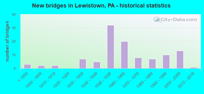
- New bridges - historical statistics
- 3Before 1900
- 21900-1909
- 21910-1919
- 71930-1939
- 51940-1949
- 321950-1959
- 201960-1969
- 81970-1979
- 71980-1989
- 101990-1999
- 132000-2009
- 12010-2019

- Reconstructed bridges - Historical Statistics
- 11920-1929
- 01930-1939
- 01940-1949
- 11950-1959
- 01960-1969
- 31970-1979
- 31980-1989
- 31990-1999
- 72000-2009
- 82010-2019
- 12020-2022


- Bridge Condition - Deck
- 1.3%Excellent
- 20.3%Very good
- 19.0%Good
- 25.3%Satisfactory
- 26.6%Fair
- 7.6%Poor

- Bridge Condition - Superstructure
- 1.1%Excellent
- 19.5%Very good
- 14.9%Good
- 27.6%Satisfactory
- 31.0%Fair
- 5.7%Poor

- Bridge Condition - Substructure
- 5.7%Very good
- 18.4%Good
- 42.5%Satisfactory
- 24.1%Fair
- 6.9%Poor
- 2.3%Critical

- Bridge Condition - Channel
- 4.5%Very good
- 10.4%Good
- 25.4%Satisfactory
- 29.9%Fair
- 26.9%Poor
- 3.0%Serious

- Bridge Condition - Culverts
- 60.0%Good
- 20.0%Satisfactory
- 20.0%Fair
Find on map >> Show street view
Structure Number: 27506, Location: UPPER MORELAND 25B12 (Lat: 40.164722, Lng: -75.125000), Route carried "on" structure: State highway 611, Year Built: 1953, Year Reconstructed: 1983, Status: Open, Structure Length: 1.25m (4.10ft), Average Daily Traffic: 45,879 (year 2022), Truck Traffic: 5%, Average Future Daily Traffic: 56,650 (year 2032), Design Load: HS 20, Features Intersected: PA TURNPIKE RAMP AB, Facility Carried by Structure: EASTON RD 3258K4
Minimum Vertical Clearance: 30+ m (98+ ft), Kilometerpoint: 11.566, Lanes on structure: 2, Lanes under structure: 2, Base Highway Network: Yes, Owner: State Highway Agency, Approaching Roadway Width: 23.8m (78.1ft), Skew: 20 degrees, Material/Design: Concrete, Design/Construction: Tee Beam, Number Of Spans In Main Unit: 1, Length of Maximum Span: 11.9m (39.0ft), Curb or Sidewalk Widths: Left: 0.5m (1.6ft), Right: 0.5m (1.6ft), Curb-To-Curb Width: 20.7m (67.9ft), Out-to-Out Width: 22.3m (73.2ft)
Condition: Deck: Satisfactory, Superstructure: Satisfactory, Substructure: Satisfactory, Operating Rating: 53.5 metric tons, Method Used To Determine Operating Rating: Field evaluation and documented engineering judgment, Inventory Rating: 31.8 metric tons, Method Used To Determine Inventory Rating: Field evaluation and documented engineering judgment, Structural Evaluation: Equal to present minimum criteria, Deck Geometry: Superior to present desirable criteria, Underclear: High priority of corrective action, Approach Roadway Alignment: Equal to present desirable criteria, Length Of Structure Improvement: 1.90m (6.23ft), Designated Inspection Frequency: Every 24 months, Inspection Date: November 2020, Bridge Improvement Cost: $7,000, Roadway Improvement Cost: $21,000, Total Project Cost: $95,000, Deck Structure Type: Concrete Cast-file-Place, Wearing Surface/Protective System: Wearing Surface: Integral Concrete
Find on map >> Show street view
Structure Number: 27507, Location: N.TURNPIKE INTERC. 25A10 (Lat: 40.179311, Lng: -75.129703), Route carried "on" structure: State highway 611, Year Built: 1959, Status: Open, Structure Length: 0.98m (3.22ft), Average Daily Traffic: 31,274 (year 2020), Truck Traffic: 13%, Average Future Daily Traffic: 38,838 (year 2032), Design Load: HS 20, Features Intersected: PENNYPACK CREEK, Facility Carried by Structure: EASTON ROAD
Minimum Vertical Clearance: 30+ m (98+ ft), Kilometerpoint: 13.366, Lanes on structure: 6, Base Highway Network: Yes, Owner: State Highway Agency, Approaching Roadway Width: 18.6m (61.0ft), Skew: 22 degrees, Material/Design: Concrete, Design/Construction: Tee Beam, Number Of Spans In Main Unit: 1, Length of Maximum Span: 9.4m (30.8ft), Curb or Sidewalk Widths: Left: 1.3m (4.3ft), Right: 1.3m (4.3ft), Curb-To-Curb Width: 21.9m (71.9ft), Out-to-Out Width: 25.1m (82.3ft)
Condition: Deck: Fair, Superstructure: Fair, Substructure: Satisfactory, Channel: Poor, Operating Rating: 68.9 metric tons, Method Used To Determine Operating Rating: Load Factor (LF), Inventory Rating: 40.8 metric tons, Method Used To Determine Inventory Rating: Load Factor (LF), Structural Evaluation: Somewhat better than minimum adequacy, Deck Geometry: High priority of corrective action, Waterway Adequacy: High priority of corrective action, Approach Roadway Alignment: Equal to present desirable criteria, Length Of Structure Improvement: 1.60m (5.25ft), Designated Inspection Frequency: Every 24 months, Inspection Date: November 2020, Bridge Improvement Cost: $29,000, Roadway Improvement Cost: $84,000, Total Project Cost: $387,000, Deck Structure Type: Concrete Cast-file-Place, Wearing Surface/Protective System: Wearing Surface: Bituminous
Find on map >> Show street view
Structure Number: 27514, Location: PERKIOMEN HEIGHTS 02E12 (Lat: 40.378572, Lng: -75.513489), Route carried "on" structure: State highway 663, Year Built: 1956, Year Reconstructed: 2017, Status: Open, Structure Length: 5.76m (18.90ft), Average Daily Traffic: 10,797 (year 2021), Truck Traffic: 20%, Average Future Daily Traffic: 11,548 (year 2032), Design Load: HL 93, Features Intersected: PERKIOMEN CREEK/2804-H10, Facility Carried by Structure: LAYFIELD ROAD
Minimum Vertical Clearance: 30+ m (98+ ft), Kilometerpoint: 19.405, Lanes on structure: 2, Base Highway Network: Yes, Owner: State Highway Agency, Approaching Roadway Width: 7.9m (25.9ft), Material/Design: Steel continuous, Design/Construction: Stringer/Multi-beam, Number Of Spans In Main Unit: 5, Length of Maximum Span: 12.8m (42.0ft), Curb-To-Curb Width: 8.5m (27.9ft), Out-to-Out Width: 9.1m (29.9ft)
Condition: Deck: Very good, Superstructure: Very good, Substructure: Satisfactory, Channel: Good, Operating Rating: 51.2 metric tons, Method Used To Determine Operating Rating: Assigned ratings based on Load and Resistance Factor Design (LRFD) reported by rating factor (RF) using HL93 loadings, Inventory Rating: 38.6 metric tons, Method Used To Determine Inventory Rating: Assigned ratings based on Load and Resistance Factor Design (LRFD) reported by rating factor (RF) using HL93 loadings, Structural Evaluation: Equal to present minimum criteria, Deck Geometry: High priority of replacement, Waterway Adequacy: Superior to present desirable criteria, Approach Roadway Alignment: Equal to present desirable criteria, Length Of Structure Improvement: 6.60m (21.65ft), Designated Inspection Frequency: Every 48 months, Underwater Inspection Frequency: Every 60 months, Inspection Date: June 2021, Underwater Inspection Date: October 2020, Bridge Improvement Cost: $38,000, Roadway Improvement Cost: $113,000, Total Project Cost: $516,000, Deck Structure Type: Concrete Cast-file-Place, Wearing Surface/Protective System: Wearing Surface: Monolithic Concrete, Deck Protection: Epoxy Coated Reinforcing
Find on map >> Show street view
Structure Number: 27525, Location: N.OF ELROY ROAD 16A03 (Lat: 40.288492, Lng: -75.338558), Route carried "on" structure: State highway , Year Built: 1988, Status: Open, Structure Length: 1.43m (4.69ft), Average Daily Traffic: 8,742 (year 2020), Truck Traffic: 10%, Average Future Daily Traffic: 9,272 (year 2032), Design Load: HS 25 or greater, Features Intersected: SKIPPACK CREEK / 3031-F4, Facility Carried by Structure: ALLENTOWN ROAD
Minimum Vertical Clearance: 30+ m (98+ ft), Kilometerpoint: 9.242, Lanes on structure: 2, Owner: State Highway Agency, Approaching Roadway Width: 12.8m (42.0ft), Material/Design: Concrete, Design/Construction: Culvert, Number Of Spans In Main Unit: 2, Length of Maximum Span: 6.1m (20.0ft)
Condition: Channel: Poor, Culverts: Satisfactory, Operating Rating: 81.6 metric tons, Method Used To Determine Operating Rating: Load Factor (LF), Inventory Rating: 49.0 metric tons, Method Used To Determine Inventory Rating: Load Factor (LF), Structural Evaluation: Equal to present minimum criteria, Waterway Adequacy: Superior to present desirable criteria, Approach Roadway Alignment: Equal to present desirable criteria, Length Of Structure Improvement: 2.10m (6.89ft), Designated Inspection Frequency: Every 24 months, Inspection Date: July 2021
Find on map >> Show street view
Structure Number: 27537, Location: NR.N.E.EXTEN.TPK. 15D01 (Lat: 40.297922, Lng: -75.386214), Route carried "on" structure: State highway , Year Built: 1992, Status: Open, Structure Length: 1.37m (4.49ft), Average Daily Traffic: 2,188 (year 2022), Truck Traffic: 5%, Average Future Daily Traffic: 2,798 (year 2032), Design Load: HS 25 or greater, Features Intersected: INDIAN CREEK / 3030-J3, Facility Carried by Structure: MILL ROAD
Minimum Vertical Clearance: 30+ m (98+ ft), Kilometerpoint: 4.777, Lanes on structure: 2, Owner: State Highway Agency, Approaching Roadway Width: 9.8m (32.2ft), Skew: 1 degrees, Material/Design: Concrete, Design/Construction: Culvert, Number Of Spans In Main Unit: 2, Length of Maximum Span: 6.1m (20.0ft)
Condition: Channel: Satisfactory, Culverts: Good, Operating Rating: 94.3 metric tons, Method Used To Determine Operating Rating: Load Factor (LF), Inventory Rating: 56.2 metric tons, Method Used To Determine Inventory Rating: Load Factor (LF), Structural Evaluation: Better than present minimum criteria, Waterway Adequacy: Better than present minimum criteria, Approach Roadway Alignment: Equal to present desirable criteria, Length Of Structure Improvement: 2.10m (6.89ft), Designated Inspection Frequency: Every 24 months, Inspection Date: July 2021
Find on map >> Show street view
Structure Number: 27549, Location: S GREEN LANE 7A10/2917E9 (Lat: 40.322514, Lng: -75.472678), Route carried "on" structure: State highway , Year Built: 1993, Status: Open, Structure Length: 4.42m (14.50ft), Average Daily Traffic: 850 (year 2022), Truck Traffic: 7%, Average Future Daily Traffic: 1,572 (year 2032), Design Load: HS 25 or greater, Features Intersected: UNAMI CREEK, Facility Carried by Structure: CRUSHER ROAD
Minimum Vertical Clearance: 30+ m (98+ ft), Kilometerpoint: 9.328, Lanes on structure: 2, Owner: State Highway Agency, Approaching Roadway Width: 7.9m (25.9ft), Skew: 4 degrees, Material/Design: Prestressed concrete continuous, Design/Construction: Box Beam or Girders - Single/Spread, Number Of Spans In Main Unit: 2, Length of Maximum Span: 21.3m (69.9ft), Curb or Sidewalk Widths: Left: 0.2m (0.7ft), Right: 0.2m (0.7ft), Curb-To-Curb Width: 11.9m (39.0ft), Out-to-Out Width: 13.0m (42.7ft)
Condition: Deck: Good, Superstructure: Very good, Substructure: Good, Channel: Fair, Operating Rating: 93.4 metric tons, Method Used To Determine Operating Rating: Load Factor (LF), Inventory Rating: 46.3 metric tons, Method Used To Determine Inventory Rating: Load Factor (LF), Structural Evaluation: Better than present minimum criteria, Deck Geometry: Better than present minimum criteria, Waterway Adequacy: Better than present minimum criteria, Approach Roadway Alignment: Meets minimum limits, Length Of Structure Improvement: 4.90m (16.08ft), Designated Inspection Frequency: Every 24 months, Inspection Date: July 2021, Deck Structure Type: Concrete Cast-file-Place, Wearing Surface/Protective System: Wearing Surface: Monolithic Concrete, Deck Protection: Epoxy Coated Reinforcing
Find on map >> Show street view
Structure Number: 27593, Location: 2 MI N 73 23C8/3256K1 (Lat: 40.187661, Lng: -75.253208), Route carried "on" structure: State highway , Year Built: 1982, Status: Open, Structure Length: 1.22m (4.00ft), Average Daily Traffic: 1,136 (year 2022), Truck Traffic: 4%, Average Future Daily Traffic: 2,919 (year 2032), Design Load: HS 20+Mod, Features Intersected: TREWELLYN CREEK, Facility Carried by Structure: GYPSY HILL ROAD
Minimum Vertical Clearance: 30+ m (98+ ft), Kilometerpoint: 1.460, Lanes on structure: 2, Owner: State Highway Agency, Approaching Roadway Width: 11.9m (39.0ft), Skew: 2 degrees, Material/Design: Prestressed concrete, Design/Construction: Box Beam or Girders - Multiple, Number Of Spans In Main Unit: 1, Length of Maximum Span: 12.2m (40.0ft), Curb or Sidewalk Widths: Left: 0.2m (0.7ft), Right: 0.2m (0.7ft), Curb-To-Curb Width: 11.6m (38.1ft), Out-to-Out Width: 12.6m (41.3ft)
Condition: Deck: Fair, Superstructure: Satisfactory, Substructure: Fair, Channel: Fair, Operating Rating: 68.9 metric tons, Method Used To Determine Operating Rating: Load Factor (LF), Inventory Rating: 35.4 metric tons, Method Used To Determine Inventory Rating: Load Factor (LF), Structural Evaluation: Somewhat better than minimum adequacy, Deck Geometry: Equal to present minimum criteria, Waterway Adequacy: Better than present minimum criteria, Approach Roadway Alignment: Equal to present desirable criteria, Length Of Structure Improvement: 1.90m (6.23ft), Designated Inspection Frequency: Every 24 months, Inspection Date: September 2020, Deck Structure Type: Concrete Cast-file-Place, Wearing Surface/Protective System: Wearing Surface: Monolithic Concrete, Deck Protection: Epoxy Coated Reinforcing
Find on map >> Show street view
Structure Number: 27599, Location: 1MI.S N.WALES BORO 22H07 (Lat: 40.195917, Lng: -75.291708), Route carried "on" structure: State highway , Year Built: 1993, Status: Open, Structure Length: 1.46m (4.79ft), Average Daily Traffic: 6,270 (year 2022), Truck Traffic: 2%, Average Future Daily Traffic: 11,288 (year 2032), Design Load: HS 25 or greater, Features Intersected: SEPTA(NOT ACTIVE)/3144D9, Facility Carried by Structure: NORTH WALES ROAD
Minimum Vertical Clearance: 30+ m (98+ ft), Kilometerpoint: 0.000, Lanes on structure: 2, Owner: State Highway Agency, Approaching Roadway Width: 10.4m (34.1ft), Skew: 3 degrees, Material/Design: Prestressed concrete, Design/Construction: Box Beam or Girders - Single/Spread, Number Of Spans In Main Unit: 1, Length of Maximum Span: 14.0m (45.9ft), Curb or Sidewalk Widths: Left: 1.7m (5.6ft), Right: 0.2m (0.7ft), Curb-To-Curb Width: 10.4m (34.1ft), Out-to-Out Width: 12.9m (42.3ft)
Condition: Deck: Good, Superstructure: Good, Substructure: Good, Operating Rating: 83.5 metric tons, Method Used To Determine Operating Rating: Load Factor (LF), Inventory Rating: 48.1 metric tons, Method Used To Determine Inventory Rating: Load Factor (LF), Structural Evaluation: Better than present minimum criteria, Deck Geometry: Meets minimum limits, Underclear: High priority of corrective action, Approach Roadway Alignment: Better than present minimum criteria, Length Of Structure Improvement: 1.40m (4.59ft), Designated Inspection Frequency: Every 24 months, Inspection Date: May 2021, Deck Structure Type: Concrete Cast-file-Place, Wearing Surface/Protective System: Wearing Surface: Monolithic Concrete, Deck Protection: Epoxy Coated Reinforcing
Find on map >> Show street view
Structure Number: 2765, Location: FORT WASHINGTON 31A07 (Lat: 40.123567, Lng: -75.200883), Route carried "on" structure: State highway , Year Built: 1994, Status: Open, Structure Length: 3.11m (10.20ft), Average Daily Traffic: 3,360 (year 2022), Truck Traffic: 4%, Average Future Daily Traffic: 5,033 (year 2032), Design Load: HS 25 or greater, Features Intersected: SANDY RUN, Facility Carried by Structure: E VALLEY GREEN RD
Minimum Vertical Clearance: 30+ m (98+ ft), Kilometerpoint: 0.000, Lanes on structure: 2, Owner: State Highway Agency, Approaching Roadway Width: 11.3m (37.1ft), Skew: 3 degrees, Material/Design: Prestressed concrete, Design/Construction: Box Beam or Girders - Multiple, Number Of Spans In Main Unit: 1, Length of Maximum Span: 30.5m (100.1ft), Curb or Sidewalk Widths: Left: 0.2m (0.7ft), Right: 0.2m (0.7ft), Curb-To-Curb Width: 11.3m (37.1ft), Out-to-Out Width: 12.4m (40.7ft)
Condition: Deck: Good, Superstructure: Good, Substructure: Good, Channel: Fair, Inventory Rating: 49.9 metric tons, Method Used To Determine Inventory Rating: Load Factor (LF), Structural Evaluation: Better than present minimum criteria, Deck Geometry: Somewhat better than minimum adequacy, Waterway Adequacy: Meets minimum limits, Approach Roadway Alignment: Equal to present desirable criteria, Length Of Structure Improvement: 3.30m (10.83ft), Designated Inspection Frequency: Every 24 months, Inspection Date: April 2020, Deck Structure Type: Concrete Cast-file-Place, Wearing Surface/Protective System: Wearing Surface: Monolithic Concrete
Find on map >> Show street view
Structure Number: 27664, Location: HATBORO 25E12 (Lat: 40.165700, Lng: -75.105192), Route carried "on" structure: State highway , Year Built: 1886, Year Reconstructed: 1931, Status: Posted for load, Structure Length: 3.29m (10.79ft), Average Daily Traffic: 11,783 (year 2022), Truck Traffic: 6%, Average Future Daily Traffic: 16,517 (year 2032), Design Load: H 15, Features Intersected: PENNYPACK CREEK, Facility Carried by Structure: WARMINSTER ROAD
Minimum Vertical Clearance: 30+ m (98+ ft), Kilometerpoint: 1.495, Lanes on structure: 2, Owner: State Highway Agency, Approaching Roadway Width: 7.3m (24.0ft), Material/Design: Steel, Design/Construction: Stringer/Multi-beam, Number Of Spans In Main Unit: 3, Length of Maximum Span: 10.1m (33.1ft), Curb or Sidewalk Widths: Left: 0.1m (0.3ft), Right: 1.5m (4.9ft), Curb-To-Curb Width: 6.8m (22.3ft), Out-to-Out Width: 9.3m (30.5ft)
Condition: Deck: Poor, Superstructure: Poor, Substructure: Poor, Channel: Poor, Operating Rating: 54.4 metric tons, Method Used To Determine Operating Rating: Load Factor (LF), Inventory Rating: 32.7 metric tons, Method Used To Determine Inventory Rating: Load Factor (LF), Structural Evaluation: Meets minimum limits, Deck Geometry: High priority of replacement, Waterway Adequacy: Equal to present minimum criteria, Approach Roadway Alignment: Better than present minimum criteria, Length Of Structure Improvement: 3.90m (12.80ft), Designated Inspection Frequency: Every 24 months, Other Special Inspection Frequency: Every 12 months, Inspection Date: September 2020, Other Special Inspection Date: September 2021, Bridge Improvement Cost: $97,000, Roadway Improvement Cost: $286,000, Total Project Cost: $1,311,000, Deck Structure Type: Concrete Cast-file-Place, Wearing Surface/Protective System: Wearing Surface: Bituminous
Find on map >> Show street view
Structure Number: 27682, Location: .1MI. N. CHELTENHAM 37G2 (Lat: 40.077283, Lng: -75.160389), Route carried "on" structure: State highway , Year Built: 1841, Year Reconstructed: 2011, Status: Open, Structure Length: 0.67m (2.20ft), Average Daily Traffic: 9,508 (year 2021), Truck Traffic: 4%, Average Future Daily Traffic: 10,127 (year 2032), Design Load: H 15, Features Intersected: ROCK CREEK, Facility Carried by Structure: LIMEKILN PIKE
Minimum Vertical Clearance: 30+ m (98+ ft), Kilometerpoint: 0.000, Lanes on structure: 2, Owner: State Highway Agency, Approaching Roadway Width: 7.0m (23.0ft), Material/Design: Masonry, Design/Construction: Arch - Deck, Number Of Spans In Main Unit: 1, Length of Maximum Span: 6.1m (20.0ft), Curb-To-Curb Width: 7.0m (23.0ft), Out-to-Out Width: 8.2m (26.9ft)
Condition: Superstructure: Satisfactory, Substructure: Satisfactory, Channel: Fair, Operating Rating: 75.3 metric tons, Method Used To Determine Operating Rating: Field evaluation and documented engineering judgment, Inventory Rating: 45.4 metric tons, Method Used To Determine Inventory Rating: Field evaluation and documented engineering judgment, Structural Evaluation: Equal to present minimum criteria, Deck Geometry: High priority of replacement, Waterway Adequacy: Superior to present desirable criteria, Approach Roadway Alignment: Equal to present desirable criteria, Length Of Structure Improvement: 1.30m (4.27ft), Designated Inspection Frequency: Every 24 months, Inspection Date: April 2020, Bridge Improvement Cost: $29,000, Roadway Improvement Cost: $84,000, Total Project Cost: $386,000, Deck Structure Type: Concrete Cast-file-Place, Wearing Surface/Protective System: Wearing Surface: Bituminous
Find on map >> Show street view
Structure Number: 27687, Location: SE SKIPPACK 21D5/3142J7 (Lat: 40.206922, Lng: -75.386783), Route carried "on" structure: State highway , Year Built: 1958, Year Reconstructed: 2011, Status: Open, Structure Length: 1.10m (3.61ft), Average Daily Traffic: 3,620 (year 2022), Truck Traffic: 4%, Average Future Daily Traffic: 4,303 (year 2032), Design Load: HL 93, Features Intersected: ZACHARIAS CREEK, Facility Carried by Structure: STUMP HALL ROAD
Minimum Vertical Clearance: 30+ m (98+ ft), Kilometerpoint: 15.250, Lanes on structure: 2, Owner: State Highway Agency, Approaching Roadway Width: 9.4m (30.8ft), Material/Design: Prestressed concrete, Design/Construction: Box Beam or Girders - Multiple, Number Of Spans In Main Unit: 1, Length of Maximum Span: 10.4m (34.1ft), Curb-To-Curb Width: 9.3m (30.5ft), Out-to-Out Width: 10.2m (33.5ft)
Condition: Deck: Very good, Superstructure: Very good, Substructure: Good, Channel: Satisfactory, Operating Rating: 56.1 metric tons, Method Used To Determine Operating Rating: Assigned ratings based on Load and Resistance Factor Design (LRFD) reported by rating factor (RF) using HL93 loadings, Inventory Rating: 36.3 metric tons, Method Used To Determine Inventory Rating: Assigned ratings based on Load and Resistance Factor Design (LRFD) reported by rating factor (RF) using HL93 loadings, Structural Evaluation: Better than present minimum criteria, Deck Geometry: Meets minimum limits, Waterway Adequacy: Better than present minimum criteria, Approach Roadway Alignment: Equal to present desirable criteria, Length Of Structure Improvement: 1.60m (5.25ft), Designated Inspection Frequency: Every 24 months, Inspection Date: March 2021, Bridge Improvement Cost: $13,000, Roadway Improvement Cost: $39,000, Total Project Cost: $179,000, Wearing Surface/Protective System: Wearing Surface: Monolithic Concrete, Deck Protection: Epoxy Coated Reinforcing
Find on map >> Show street view
Structure Number: 27692, Location: 1MI.N.W.MAIN ST. (Lat: 40.145883, Lng: -75.368731), Route carried "on" structure: State highway , Year Built: 1986, Status: Open, Structure Length: 0.82m (2.69ft), Average Daily Traffic: 4,751 (year 2021), Truck Traffic: 9%, Average Future Daily Traffic: 7,966 (year 2032), Design Load: HS 25 or greater, Features Intersected: BRANCH STONY CR/ 3255-A7, Facility Carried by Structure: BURNSIDE AVENUE
Minimum Vertical Clearance: 30+ m (98+ ft), Kilometerpoint: 1.209, Lanes on structure: 2, Owner: State Highway Agency, Approaching Roadway Width: 12.2m (40.0ft), Material/Design: Prestressed concrete, Design/Construction: Slab, Number Of Spans In Main Unit: 1, Length of Maximum Span: 7.9m (25.9ft), Curb or Sidewalk Widths: Left: 1.7m (5.6ft), Right: 0.0m, Curb-To-Curb Width: 12.4m (40.7ft), Out-to-Out Width: 14.8m (48.6ft)
Condition: Deck: Satisfactory, Superstructure: Good, Substructure: Good, Channel: Fair, Inventory Rating: 58.1 metric tons, Method Used To Determine Inventory Rating: Load Factor (LF), Structural Evaluation: Better than present minimum criteria, Deck Geometry: Equal to present minimum criteria, Waterway Adequacy: Equal to present minimum criteria, Approach Roadway Alignment: Equal to present desirable criteria, Length Of Structure Improvement: 1.40m (4.59ft), Designated Inspection Frequency: Every 24 months, Inspection Date: July 2021, Deck Structure Type: Concrete Precast Panels, Wearing Surface/Protective System: Wearing Surface: Monolithic Concrete, Deck Protection: Epoxy Coated Reinforcing
Find on map >> Show street view
Structure Number: 27695, Location: NORRISTOWN 28H2/3255D7 (Lat: 40.147367, Lng: -75.354186), Route carried "on" structure: State highway , Year Built: 1911, Year Reconstructed: 2012, Status: Closed, Structure Length: 1.25m (4.10ft), Average Daily Traffic: 12,729 (year 2022), Truck Traffic: 6%, Average Future Daily Traffic: 14,614 (year 2032), Design Load: H 15, Features Intersected: KEPNER CREEK, Facility Carried by Structure: WHITEHALL ROAD
Minimum Vertical Clearance: 30+ m (98+ ft), Kilometerpoint: 2.142, Lanes on structure: 2, Owner: State Highway Agency, Approaching Roadway Width: 7.9m (25.9ft), Material/Design: Masonry, Design/Construction: Arch - Deck, Number Of Spans In Main Unit: 2, Length of Maximum Span: 5.5m (18.0ft), Curb-To-Curb Width: 9.3m (30.5ft), Out-to-Out Width: 10.7m (35.1ft)
Condition: Deck: Very good, Superstructure: Very good, Substructure: Critical, Channel: Serious, Operating Rating: 78.0 metric tons, Method Used To Determine Operating Rating: Field evaluation and documented engineering judgment, Inventory Rating: 47.2 metric tons, Method Used To Determine Inventory Rating: Field evaluation and documented engineering judgment, Structural Evaluation: High priority of replacement, Deck Geometry: High priority of corrective action, Waterway Adequacy: Equal to present minimum criteria, Approach Roadway Alignment: Equal to present desirable criteria, Length Of Structure Improvement: 1.80m (5.91ft), Designated Inspection Frequency: Every 24 months, Underwater Inspection Frequency: Every 24 months, Inspection Date: July 2020, Underwater Inspection Date: September 2021, Bridge Improvement Cost: $52,000, Roadway Improvement Cost: $153,000, Total Project Cost: $702,000, Deck Structure Type: Concrete Cast-file-Place, Wearing Surface/Protective System: Wearing Surface: Bituminous, Membrane: Other, Deck Protection: Epoxy Coated Reinforcing
Find on map >> Show street view
Structure Number: 27701, Location: NEAR NORRISTOWN 29B04 (Lat: 40.138025, Lng: -75.329142), Route carried "on" structure: State highway , Year Built: 1949, Status: Open, Structure Length: 2.13m (6.99ft), Average Daily Traffic: 17,595 (year 2022), Truck Traffic: 6%, Average Future Daily Traffic: 23,502 (year 2032), Design Load: HS 20, Features Intersected: BRANCH STONY CR/ 3255-H8, Facility Carried by Structure: SWEDE ROAD
Minimum Vertical Clearance: 30+ m (98+ ft), Kilometerpoint: 0.000, Lanes on structure: 2, Base Highway Network: Yes, Owner: State Highway Agency, Approaching Roadway Width: 9.1m (29.9ft), Material/Design: Concrete, Design/Construction: Arch - Deck, Number Of Spans In Main Unit: 1, Length of Maximum Span: 18.3m (60.0ft), Curb or Sidewalk Widths: Left: 1.4m (4.6ft), Right: 1.4m (4.6ft), Curb-To-Curb Width: 9.2m (30.2ft), Out-to-Out Width: 13.1m (43.0ft)
Condition: Superstructure: Fair, Substructure: Fair, Channel: Poor, Operating Rating: 62.6 metric tons, Method Used To Determine Operating Rating: Field evaluation and documented engineering judgment, Inventory Rating: 37.2 metric tons, Method Used To Determine Inventory Rating: Field evaluation and documented engineering judgment, Structural Evaluation: Somewhat better than minimum adequacy, Deck Geometry: High priority of corrective action, Waterway Adequacy: Equal to present minimum criteria, Approach Roadway Alignment: Equal to present desirable criteria, Length Of Structure Improvement: 2.80m (9.19ft), Designated Inspection Frequency: Every 24 months, Inspection Date: August 2021, Bridge Improvement Cost: $18,000, Roadway Improvement Cost: $52,000, Total Project Cost: $238,000
Find on map >> Show street view
Structure Number: 27706, Location: PLYMOUTH TWP.35D01/3367K8 (Lat: 40.082297, Lng: -75.315797), Route carried "on" structure: State highway , Year Built: 1964, Status: Open, Structure Length: 1.83m (6.00ft), Average Daily Traffic: 7,677 (year 2022), Truck Traffic: 14%, Average Future Daily Traffic: 9,664 (year 2032), Design Load: HS 20, Features Intersected: UPPER MERION & PLYMOUTH, Facility Carried by Structure: CONSHOHOCKEN ROAD
Minimum Vertical Clearance: 30+ m (98+ ft), Kilometerpoint: 0.908, Lanes on structure: 2, Lanes under structure: 1, Owner: Railroad, Approaching Roadway Width: 9.4m (30.8ft), Skew: 4 degrees, Material/Design: Prestressed concrete, Design/Construction: Box Beam or Girders - Multiple, Number Of Spans In Main Unit: 1, Length of Maximum Span: 18.0m (59.1ft), Curb or Sidewalk Widths: Left: 0.0m, Right: 0.4m (1.3ft), Curb-To-Curb Width: 21.1m (69.2ft), Out-to-Out Width: 21.4m (70.2ft)
Condition: Deck: Satisfactory, Superstructure: Good, Substructure: Satisfactory, Operating Rating: 80.7 metric tons, Method Used To Determine Operating Rating: Load Factor (LF), Inventory Rating: 42.6 metric tons, Method Used To Determine Inventory Rating: Load Factor (LF), Structural Evaluation: Equal to present minimum criteria, Deck Geometry: Superior to present desirable criteria, Underclear: Somewhat better than minimum adequacy, Approach Roadway Alignment: Equal to present desirable criteria, Length Of Structure Improvement: 2.50m (8.20ft), Designated Inspection Frequency: Every 24 months, Inspection Date: October 2019, Bridge Improvement Cost: $41,000, Roadway Improvement Cost: $120,000, Total Project Cost: $550,000, Deck Structure Type: Concrete Cast-file-Place, Wearing Surface/Protective System: Wearing Surface: Monolithic Concrete
Find on map >> Show street view
Structure Number: 27715, Location: WHITEMARSH 30H5/3257E9 (Lat: 40.131808, Lng: -75.222222), Route carried "on" structure: State highway , Year Built: 1963, Year Reconstructed: 2011, Status: Open, Structure Length: 3.23m (10.60ft), Average Daily Traffic: 5,062 (year 2021), Truck Traffic: 9%, Average Future Daily Traffic: 7,847 (year 2032), Design Load: HL 93, Features Intersected: WISSAHICKON CREEK, Facility Carried by Structure: LAFAYETTE AVENUE
Minimum Vertical Clearance: 30+ m (98+ ft), Kilometerpoint: 7.339, Lanes on structure: 2, Owner: State Highway Agency, Approaching Roadway Width: 11.0m (36.1ft), Skew: 1 degrees, Material/Design: Prestressed concrete continuous, Design/Construction: Box Beam or Girders - Multiple, Number Of Spans In Main Unit: 2, Length of Maximum Span: 15.8m (51.8ft), Curb-To-Curb Width: 9.3m (30.5ft), Out-to-Out Width: 10.2m (33.5ft)
Condition: Deck: Very good, Superstructure: Very good, Substructure: Satisfactory, Channel: Fair, Operating Rating: 55.4 metric tons, Method Used To Determine Operating Rating: Assigned ratings based on Load and Resistance Factor Design (LRFD) reported by rating factor (RF) using HL93 loadings, Inventory Rating: 35.0 metric tons, Method Used To Determine Inventory Rating: Assigned ratings based on Load and Resistance Factor Design (LRFD) reported by rating factor (RF) using HL93 loadings, Structural Evaluation: Equal to present minimum criteria, Deck Geometry: High priority of corrective action, Waterway Adequacy: Equal to present minimum criteria, Approach Roadway Alignment: Equal to present desirable criteria, Length Of Structure Improvement: 3.90m (12.80ft), Designated Inspection Frequency: Every 24 months, Inspection Date: May 2021, Bridge Improvement Cost: $21,000, Roadway Improvement Cost: $61,000, Total Project Cost: $280,000, Deck Structure Type: Concrete Cast-file-Place, Wearing Surface/Protective System: Wearing Surface: Monolithic Concrete, Deck Protection: Epoxy Coated Reinforcing
Find on map >> Show street view
Structure Number: 27729, Location: UPPER MERION TWP. 35B01 (Lat: 40.085508, Lng: -75.329344), Route carried "on" structure: State highway , Year Built: 1998, Status: Open, Structure Length: 0.61m (2.00ft), Average Daily Traffic: 1,878 (year 2021), Truck Traffic: 24%, Average Future Daily Traffic: 3,518 (year 2032), Design Load: HS 25 or greater, Features Intersected: MATSUNK CREEK / 3367-H7, Facility Carried by Structure: FLINT HILL ROAD
Minimum Vertical Clearance: 30+ m (98+ ft), Kilometerpoint: 0.000, Lanes on structure: 2, Owner: State Highway Agency, Approaching Roadway Width: 8.5m (27.9ft), Skew: 1 degrees, Material/Design: Concrete, Design/Construction: Culvert, Number Of Spans In Main Unit: 1, Length of Maximum Span: 6.1m (20.0ft), Curb or Sidewalk Widths: Left: 0.2m (0.7ft), Right: 0.2m (0.7ft), Curb-To-Curb Width: 8.3m (27.2ft), Out-to-Out Width: 9.6m (31.5ft)
Condition: Channel: Fair, Culverts: Good, Operating Rating: 75.3 metric tons, Method Used To Determine Operating Rating: Load Factor (LF), Inventory Rating: 44.5 metric tons, Method Used To Determine Inventory Rating: Load Factor (LF), Structural Evaluation: Better than present minimum criteria, Deck Geometry: Meets minimum limits, Waterway Adequacy: Better than present minimum criteria, Approach Roadway Alignment: Equal to present desirable criteria, Length Of Structure Improvement: 1.60m (5.25ft), Designated Inspection Frequency: Every 24 months, Inspection Date: August 2021, Bridge Improvement Cost: $26,000, Roadway Improvement Cost: $78,000, Total Project Cost: $356,000
Find on map >> Show street view
Structure Number: 27756, Location: @ GULPH RD 34K03 / 3367E9 (Lat: 40.072953, Lng: -75.343489), Route carried "on" structure: State highway , Year Built: 1997, Status: Open, Structure Length: 2.44m (8.01ft), Average Daily Traffic: 2,461 (year 2022), Truck Traffic: 11%, Average Future Daily Traffic: 3,222 (year 2032), Design Load: HS 25 or greater, Features Intersected: P&W RR (SEPTA), Facility Carried by Structure: SWEDELAND ROAD
Minimum Vertical Clearance: 30+ m (98+ ft), Kilometerpoint: 0.000, Lanes on structure: 2, Owner: State Highway Agency, Approaching Roadway Width: 15.2m (49.9ft), Skew: 3 degrees, Material/Design: Prestressed concrete, Design/Construction: Box Beam or Girders - Single/Spread, Number Of Spans In Main Unit: 1, Length of Maximum Span: 24.4m (80.1ft), Curb or Sidewalk Widths: Left: 0.2m (0.7ft), Right: 0.2m (0.7ft), Curb-To-Curb Width: 15.2m (49.9ft), Out-to-Out Width: 16.3m (53.5ft)
Condition: Deck: Good, Superstructure: Good, Substructure: Good, Operating Rating: 91.6 metric tons, Method Used To Determine Operating Rating: Load Factor (LF), Inventory Rating: 50.8 metric tons, Method Used To Determine Inventory Rating: Load Factor (LF), Structural Evaluation: Better than present minimum criteria, Deck Geometry: Superior to present desirable criteria, Underclear: High priority of corrective action, Approach Roadway Alignment: Somewhat better than minimum adequacy, Length Of Structure Improvement: 1.40m (4.59ft), Designated Inspection Frequency: Every 24 months, Inspection Date: January 2020, Bridge Improvement Cost: $419,000, Roadway Improvement Cost: $3,977,000, Total Project Cost: $5,651,000, Deck Structure Type: Concrete Cast-file-Place, Wearing Surface/Protective System: Wearing Surface: Monolithic Concrete, Deck Protection: Epoxy Coated Reinforcing
Find on map >> Show street view
Structure Number: 27798, Location: GRATERFORD 20C2/3141G5 (Lat: 40.224078, Lng: -75.456600), Route carried "on" structure: State highway , Year Built: 1964, Status: Open, Structure Length: 0.94m (3.08ft), Average Daily Traffic: 2,761 (year 2021), Truck Traffic: 4%, Average Future Daily Traffic: 4,409 (year 2032), Design Load: HS 20, Features Intersected: LODAL CREEK, Facility Carried by Structure: WARTMAN ROAD
Minimum Vertical Clearance: 30+ m (98+ ft), Kilometerpoint: 0.000, Lanes on structure: 2, Owner: State Highway Agency, Approaching Roadway Width: 12.2m (40.0ft), Skew: 1 degrees, Material/Design: Concrete, Design/Construction: Tee Beam, Number Of Spans In Main Unit: 1, Length of Maximum Span: 9.1m (29.9ft), Curb or Sidewalk Widths: Left: 0.5m (1.6ft), Right: 0.5m (1.6ft), Curb-To-Curb Width: 11.1m (36.4ft), Out-to-Out Width: 12.3m (40.4ft)
Condition: Deck: Fair, Superstructure: Good, Substructure: Satisfactory, Channel: Poor, Operating Rating: 51.7 metric tons, Method Used To Determine Operating Rating: Load Factor (LF), Inventory Rating: 30.8 metric tons, Method Used To Determine Inventory Rating: Load Factor (LF), Structural Evaluation: Equal to present minimum criteria, Deck Geometry: Somewhat better than minimum adequacy, Waterway Adequacy: Better than present minimum criteria, Approach Roadway Alignment: Better than present minimum criteria, Length Of Structure Improvement: 1.60m (5.25ft), Designated Inspection Frequency: Every 24 months, Inspection Date: May 2021, Deck Structure Type: Concrete Cast-file-Place, Wearing Surface/Protective System: Wearing Surface: Bituminous
Find on map >> Show street view
Structure Number: 27799, Location: GRATERFORD 20D1/3141H5 (Lat: 40.224831, Lng: -75.452683), Route carried "on" structure: State highway , Year Built: 1957, Year Reconstructed: 2016, Status: Open, Structure Length: 6.64m (21.78ft), Average Daily Traffic: 2,047 (year 2021), Truck Traffic: 3%, Average Future Daily Traffic: 3,672 (year 2032), Design Load: HL 93, Features Intersected: PERKIOMEN CREEK, Facility Carried by Structure: GRATERFORD ROAD
Minimum Vertical Clearance: 30+ m (98+ ft), Kilometerpoint: 0.010, Lanes on structure: 2, Owner: State Highway Agency, Approaching Roadway Width: 7.3m (24.0ft), Material/Design: Prestressed concrete continuous, Design/Construction: Box Beam or Girders - Single/Spread, Number Of Spans In Main Unit: 3, Length of Maximum Span: 21.6m (70.9ft), Curb-To-Curb Width: 7.3m (24.0ft), Out-to-Out Width: 8.2m (26.9ft)
Condition: Deck: Very good, Superstructure: Very good, Substructure: Very good, Channel: Poor, Operating Rating: 51.2 metric tons, Method Used To Determine Operating Rating: Assigned ratings based on Load and Resistance Factor Design (LRFD) reported by rating factor (RF) using HL93 loadings, Inventory Rating: 39.5 metric tons, Method Used To Determine Inventory Rating: Assigned ratings based on Load and Resistance Factor Design (LRFD) reported by rating factor (RF) using HL93 loadings, Structural Evaluation: Equal to present desirable criteria, Deck Geometry: High priority of replacement, Waterway Adequacy: Equal to present minimum criteria, Approach Roadway Alignment: Equal to present desirable criteria, Length Of Structure Improvement: 7.70m (25.26ft), Designated Inspection Frequency: Every 24 months, Inspection Date: May 2020, Bridge Improvement Cost: $81,000, Roadway Improvement Cost: $239,000, Total Project Cost: $1,095,000, Deck Structure Type: Concrete Cast-file-Place, Wearing Surface/Protective System: Wearing Surface: Monolithic Concrete, Deck Protection: Epoxy Coated Reinforcing
Find on map >> Show street view
Structure Number: 27817, Location: W OF ZIEGLERV 3028H7 (Lat: 40.272611, Lng: -75.514539), Route carried "on" structure: State highway , Year Built: 1966, Status: Open, Structure Length: 3.60m (11.81ft), Average Daily Traffic: 1,917 (year 2021), Truck Traffic: 8%, Average Future Daily Traffic: 1,564 (year 2032), Design Load: HS 20, Features Intersected: SWAMP CREEK, Facility Carried by Structure: NEIFFER ROAD
Minimum Vertical Clearance: 30+ m (98+ ft), Kilometerpoint: 2.369, Lanes on structure: 2, Owner: State Highway Agency, Approaching Roadway Width: 10.7m (35.1ft), Skew: 4 degrees, Material/Design: Prestressed concrete, Design/Construction: Box Beam or Girders - Single/Spread, Number Of Spans In Main Unit: 2, Length of Maximum Span: 20.1m (65.9ft), Curb or Sidewalk Widths: Left: 0.2m (0.7ft), Right: 0.2m (0.7ft), Curb-To-Curb Width: 10.3m (33.8ft), Out-to-Out Width: 11.6m (38.1ft)
Condition: Deck: Satisfactory, Superstructure: Fair, Substructure: Fair, Channel: Poor, Operating Rating: 84.4 metric tons, Method Used To Determine Operating Rating: Load Factor (LF), Inventory Rating: 45.4 metric tons, Method Used To Determine Inventory Rating: Load Factor (LF), Structural Evaluation: Somewhat better than minimum adequacy, Deck Geometry: Somewhat better than minimum adequacy, Waterway Adequacy: Equal to present desirable criteria, Approach Roadway Alignment: Better than present minimum criteria, Length Of Structure Improvement: 4.50m (14.76ft), Designated Inspection Frequency: Every 24 months, Inspection Date: July 2021, Deck Structure Type: Concrete Cast-file-Place, Wearing Surface/Protective System: Wearing Surface: Monolithic Concrete
Find on map >> Show street view
Structure Number: 27819, Location: LINFIELD;LIMERICK (Lat: 40.207500, Lng: -75.572000), Route carried "on" structure: State highway , Year Built: 1968, Status: Open, Structure Length: 3.57m (11.71ft), Average Daily Traffic: 7,211 (year 2021), Truck Traffic: 5%, Average Future Daily Traffic: 8,804 (year 2032), Design Load: HL 93, Features Intersected: NS MP 34.71 / 3139J07, Facility Carried by Structure: MAIN STREET
Minimum Vertical Clearance: 30+ m (98+ ft), Kilometerpoint: 0.000, Lanes on structure: 2, Owner: Railroad, Approaching Roadway Width: 11.0m (36.1ft), Skew: 5 degrees, Material/Design: Steel, Design/Construction: Stringer/Multi-beam, Number Of Spans In Main Unit: 1, Length of Maximum Span: 32.6m (107.0ft), Curb or Sidewalk Widths: Left: 1.7m (5.6ft), Right: 0.2m (0.7ft), Curb-To-Curb Width: 10.4m (34.1ft), Out-to-Out Width: 13.4m (44.0ft)
Condition: Deck: Very good, Superstructure: Satisfactory, Substructure: Satisfactory, Operating Rating: 83.5 metric tons, Method Used To Determine Operating Rating: Load Factor (LF), Inventory Rating: 49.9 metric tons, Method Used To Determine Inventory Rating: Load Factor (LF), Structural Evaluation: Equal to present minimum criteria, Deck Geometry: Meets minimum limits, Underclear: High priority of corrective action, Approach Roadway Alignment: Better than present minimum criteria, Length Of Structure Improvement: 4.50m (14.76ft), Designated Inspection Frequency: Every 24 months, Inspection Date: July 2021, Bridge Improvement Cost: $38,000, Roadway Improvement Cost: $112,000, Total Project Cost: $513,000, Deck Structure Type: Concrete Cast-file-Place, Wearing Surface/Protective System: Wearing Surface: Monolithic Concrete, Deck Protection: Epoxy Coated Reinforcing
Find on map >> Show street view
Structure Number: 27831, Location: LOWER POTTSGROVE 12F11 (Lat: 40.241214, Lng: -75.575819), Route carried "on" structure: State highway , Year Built: 1984, Status: Open, Structure Length: 8.38m (27.49ft), Average Daily Traffic: 19,813 (year 2022), Truck Traffic: 8%, Average Future Daily Traffic: 21,123 (year 2032), Design Load: HS 20+Mod, Features Intersected: POTTSTOWN EXPWAY/3139-H2, Facility Carried by Structure: EVERGREEN ROAD
Minimum Vertical Clearance: 30+ m (98+ ft), Kilometerpoint: 1.328, Lanes on structure: 2, Lanes under structure: 4, Owner: State Highway Agency, Approaching Roadway Width: 23.8m (78.1ft), Skew: 33 degrees, Material/Design: Steel continuous, Design/Construction: Stringer/Multi-beam, Number Of Spans In Main Unit: 2, Length of Maximum Span: 45.7m (149.9ft), Curb or Sidewalk Widths: Left: 0.2m (0.7ft), Right: 0.2m (0.7ft), Curb-To-Curb Width: 22.7m (74.5ft), Out-to-Out Width: 23.8m (78.1ft)
Condition: Deck: Good, Superstructure: Satisfactory, Substructure: Good, Operating Rating: 88.9 metric tons, Method Used To Determine Operating Rating: Load Factor (LF), Inventory Rating: 53.5 metric tons, Method Used To Determine Inventory Rating: Load Factor (LF), Structural Evaluation: Equal to present minimum criteria, Deck Geometry: Superior to present desirable criteria, Underclear: High priority of corrective action, Approach Roadway Alignment: Better than present minimum criteria, Length Of Structure Improvement: 9.40m (30.84ft), Designated Inspection Frequency: Every 24 months, Inspection Date: May 2021, Deck Structure Type: Concrete Cast-file-Place, Wearing Surface/Protective System: Wearing Surface: Monolithic Concrete
Find on map >> Show street view
Structure Number: 27837, Location: L. POTTSGROVE 11J7/3027A9 (Lat: 40.261844, Lng: -75.621472), Route carried "on" structure: State highway , Year Built: 1932, Status: Open, Structure Length: 1.22m (4.00ft), Average Daily Traffic: 1,149 (year 2020), Truck Traffic: 2%, Average Future Daily Traffic: 1,893 (year 2032), Design Load: HS 15, Features Intersected: SPROGELS RUN, Facility Carried by Structure: BUCHERT ROAD
Minimum Vertical Clearance: 30+ m (98+ ft), Kilometerpoint: 2.842, Lanes on structure: 2, Owner: State Highway Agency, Approaching Roadway Width: 6.1m (20.0ft), Skew: 3 degrees, Material/Design: Concrete continuous, Design/Construction: Slab, Number Of Spans In Main Unit: 2, Length of Maximum Span: 6.1m (20.0ft), Curb-To-Curb Width: 6.1m (20.0ft), Out-to-Out Width: 6.9m (22.6ft)
Condition: Deck: Poor, Superstructure: Poor, Substructure: Fair, Channel: Poor, Operating Rating: 73.5 metric tons, Method Used To Determine Operating Rating: Load Factor (LF), Inventory Rating: 43.5 metric tons, Method Used To Determine Inventory Rating: Load Factor (LF), Structural Evaluation: Meets minimum limits, Deck Geometry: High priority of replacement, Waterway Adequacy: Better than present minimum criteria, Approach Roadway Alignment: Meets minimum limits, Length Of Structure Improvement: 1.90m (6.23ft), Designated Inspection Frequency: Every 24 months, Inspection Date: April 2021, Bridge Improvement Cost: $36,000, Roadway Improvement Cost: $105,000, Total Project Cost: $483,000, Deck Structure Type: Concrete Cast-file-Place, Wearing Surface/Protective System: Wearing Surface: Bituminous
Find on map >> Show street view
Structure Number: 27838, Location: GILBERTSVILLE 12G4/3027J6 (Lat: 40.280556, Lng: -75.570000), Route carried "on" structure: State highway , Year Built: 1950, Status: Open, Structure Length: 0.82m (2.69ft), Average Daily Traffic: 429 (year 2022), Truck Traffic: 6%, Average Future Daily Traffic: 428 (year 2032), Design Load: HS 20, Features Intersected: BRANCH SWAMP CREEK, Facility Carried by Structure: NEW HANOVER SQUARE
Minimum Vertical Clearance: 30+ m (98+ ft), Kilometerpoint: 0.744, Lanes on structure: 2, Owner: State Highway Agency, Approaching Roadway Width: 7.3m (24.0ft), Skew: 3 degrees, Material/Design: Concrete, Design/Construction: Tee Beam, Number Of Spans In Main Unit: 1, Length of Maximum Span: 7.6m (24.9ft), Curb or Sidewalk Widths: Left: 0.2m (0.7ft), Right: 0.2m (0.7ft), Curb-To-Curb Width: 7.3m (24.0ft), Out-to-Out Width: 8.5m (27.9ft)
Condition: Deck: Fair, Superstructure: Satisfactory, Substructure: Satisfactory, Channel: Fair, Operating Rating: 62.6 metric tons, Method Used To Determine Operating Rating: Load Factor (LF), Inventory Rating: 37.2 metric tons, Method Used To Determine Inventory Rating: Load Factor (LF), Structural Evaluation: Equal to present minimum criteria, Deck Geometry: Meets minimum limits, Waterway Adequacy: Better than present minimum criteria, Approach Roadway Alignment: Equal to present desirable criteria, Length Of Structure Improvement: 1.40m (4.59ft), Designated Inspection Frequency: Every 24 months, Inspection Date: August 2021, Bridge Improvement Cost: $14,000, Roadway Improvement Cost: $42,000, Total Project Cost: $191,000, Deck Structure Type: Concrete Cast-file-Place, Wearing Surface/Protective System: Wearing Surface: Bituminous
Find on map >> Show street view
Structure Number: 27841, Location: .5MI.TO LR 46067 20G11 (Lat: 40.171597, Lng: -75.430736), Route carried "on" structure: State highway , Year Built: 1935, Year Reconstructed: 1986, Status: Open, Structure Length: 4.97m (16.31ft), Average Daily Traffic: 9,536 (year 2020), Truck Traffic: 5%, Average Future Daily Traffic: 14,993 (year 2032), Design Load: HS 25 or greater, Features Intersected: SKIPPACK CREEK / 3254-B3, Facility Carried by Structure: RIDGE PIKE
Minimum Vertical Clearance: 30+ m (98+ ft), Kilometerpoint: 3.796, Lanes on structure: 2, Base Highway Network: Yes, Owner: State Highway Agency, Approaching Roadway Width: 12.8m (42.0ft), Skew: 4 degrees, Material/Design: Steel, Design/Construction: Girder and Floorbeam System, Number Of Spans In Main Unit: 2, Length of Maximum Span: 23.2m (76.1ft), Curb or Sidewalk Widths: Left: 1.6m (5.2ft), Right: 1.6m (5.2ft), Curb-To-Curb Width: 12.8m (42.0ft), Out-to-Out Width: 14.0m (45.9ft)
Condition: Deck: Satisfactory, Superstructure: Fair, Substructure: Fair, Channel: Fair, Operating Rating: 60.8 metric tons, Method Used To Determine Operating Rating: Load Factor (LF), Inventory Rating: 36.3 metric tons, Method Used To Determine Inventory Rating: Load Factor (LF), Structural Evaluation: Somewhat better than minimum adequacy, Deck Geometry: Somewhat better than minimum adequacy, Waterway Adequacy: Equal to present minimum criteria, Approach Roadway Alignment: Equal to present desirable criteria, Length Of Structure Improvement: 5.90m (19.36ft), Designated Inspection Frequency: Every 24 months, Critical Feature Inspection Frequency: Every 24 months, Inspection Date: September 2021, Critical Feature Inspection Date: September 2021, Deck Structure Type: Concrete Cast-file-Place, Wearing Surface/Protective System: Wearing Surface: Monolithic Concrete, Deck Protection: Epoxy Coated Reinforcing
Find on map >> Show street view
Structure Number: 27845, Location: LIMERICK 12G11 (Lat: 40.243128, Lng: -75.570725), Route carried "on" structure: Bypass State highway , Year Built: 1965, Status: Open, Structure Length: 3.96m (12.99ft), Average Daily Traffic: 4,637 (year 2021), Truck Traffic: 4%, Average Future Daily Traffic: 8,962 (year 2032), Design Load: HS 20, Features Intersected: TOWNSHIP LINE ROAD, Facility Carried by Structure: RIDGE PIKE
Minimum Vertical Clearance: 30+ m (98+ ft), Kilometerpoint: 18.691, Lanes on structure: 2, Lanes under structure: 4, Base Highway Network: Yes, Owner: State Highway Agency, Approaching Roadway Width: 12.2m (40.0ft), Skew: 4 degrees, Material/Design: Steel, Design/Construction: Stringer/Multi-beam, Number Of Spans In Main Unit: 1, Length of Maximum Span: 37.8m (124.0ft), Curb or Sidewalk Widths: Left: 0.5m (1.6ft), Right: 0.5m (1.6ft), Curb-To-Curb Width: 11.6m (38.1ft), Out-to-Out Width: 13.3m (43.6ft)
Condition: Deck: Fair, Superstructure: Satisfactory, Substructure: Satisfactory, Operating Rating: 70.8 metric tons, Method Used To Determine Operating Rating: Load Factor (LF), Inventory Rating: 41.7 metric tons, Method Used To Determine Inventory Rating: Load Factor (LF), Structural Evaluation: Equal to present minimum criteria, Deck Geometry: Better than present minimum criteria, Underclear: Meets minimum limits, Approach Roadway Alignment: Better than present minimum criteria, Length Of Structure Improvement: 4.60m (15.09ft), Designated Inspection Frequency: Every 24 months, Inspection Date: May 2021, Deck Structure Type: Concrete Cast-file-Place, Wearing Surface/Protective System: Wearing Surface: Bituminous
Find on map >> Show street view
Structure Number: 27855, Location: L. POTTSGR. 11K08/3027B9 (Lat: 40.256944, Lng: -75.615278), Route carried "on" structure: State highway , Year Built: 1966, Status: Open, Structure Length: 0.70m (2.30ft), Average Daily Traffic: 3,851 (year 2022), Truck Traffic: 3%, Average Future Daily Traffic: 6,923 (year 2032), Design Load: HS 20, Features Intersected: SPROGELS RUN, Facility Carried by Structure: KEIM STREET
Minimum Vertical Clearance: 30+ m (98+ ft), Kilometerpoint: 0.000, Lanes on structure: 2, Owner: State Highway Agency, Approaching Roadway Width: 7.9m (25.9ft), Skew: 2 degrees, Material/Design: Concrete, Design/Construction: Culvert, Number Of Spans In Main Unit: 1, Length of Maximum Span: 6.4m (21.0ft)
Condition: Channel: Fair, Culverts: Good, Operating Rating: 76.2 metric tons, Method Used To Determine Operating Rating: Load Factor (LF), Inventory Rating: 45.4 metric tons, Method Used To Determine Inventory Rating: Load Factor (LF), Structural Evaluation: Better than present minimum criteria, Waterway Adequacy: Superior to present desirable criteria, Approach Roadway Alignment: Equal to present desirable criteria, Length Of Structure Improvement: 1.30m (4.27ft), Designated Inspection Frequency: Every 24 months, Inspection Date: August 2021
Find on map >> Show street view
Structure Number: 27856, Location: E POTTSTOWN 11K12/3139B3 (Lat: 40.235100, Lng: -75.616900), Route carried "on" structure: State highway , Year Built: 1942, Status: Posted for load, Structure Length: 3.23m (10.60ft), Average Daily Traffic: 15,487 (year 2021), Truck Traffic: 4%, Average Future Daily Traffic: 22,609 (year 2032), Design Load: H 20, Features Intersected: NORFOLK SOUTHERN RR, Facility Carried by Structure: ARMAND HAMMER BLVD
Minimum Vertical Clearance: 30+ m (98+ ft), Kilometerpoint: 0.000, Lanes on structure: 2, Owner: Railroad, Approaching Roadway Width: 12.8m (42.0ft), Skew: 1 degrees, Material/Design: Steel, Design/Construction: Girder and Floorbeam System, Number Of Spans In Main Unit: 1, Length of Maximum Span: 30.8m (101.0ft), Curb or Sidewalk Widths: Left: 1.5m (4.9ft), Right: 0.2m (0.7ft), Curb-To-Curb Width: 8.1m (26.6ft), Out-to-Out Width: 10.6m (34.8ft)
Condition: Deck: Poor, Superstructure: Fair, Substructure: Poor, Operating Rating: 52.6 metric tons, Method Used To Determine Operating Rating: Load Factor (LF), Inventory Rating: 30.8 metric tons, Method Used To Determine Inventory Rating: Load Factor (LF), Structural Evaluation: Meets minimum limits, Deck Geometry: High priority of replacement, Underclear: High priority of corrective action, Approach Roadway Alignment: Equal to present desirable criteria, Length Of Structure Improvement: 4.00m (13.12ft), Designated Inspection Frequency: Every 24 months, Critical Feature Inspection Frequency: Every 12 months, Other Special Inspection Frequency: Every 12 months, Inspection Date: May 2021, Critical Feature Inspection Date: May 2021, Other Special Inspection Date: May 2021, Bridge Improvement Cost: $37,000, Roadway Improvement Cost: $109,000, Total Project Cost: $500,000, Deck Structure Type: Concrete Cast-file-Place, Wearing Surface/Protective System: Wearing Surface: Bituminous
Find on map >> Show street view
Structure Number: 27857, Location: E POTTSTOWN 11K12/3139B3 (Lat: 40.237497, Lng: -75.615997), Route carried "on" structure: State highway , Year Built: 1942, Status: Open, Structure Length: 3.93m (12.89ft), Average Daily Traffic: 15,487 (year 2021), Truck Traffic: 4%, Average Future Daily Traffic: 22,609 (year 2032), Design Load: H 20, Features Intersected: NORFOLK SOUTHERN RR, Facility Carried by Structure: ARMAND HAMMER BLVD
Minimum Vertical Clearance: 30+ m (98+ ft), Kilometerpoint: 0.000, Lanes on structure: 2, Owner: Railroad, Approaching Roadway Width: 10.4m (34.1ft), Material/Design: Steel, Design/Construction: Girder and Floorbeam System, Number Of Spans In Main Unit: 1, Length of Maximum Span: 38.4m (126.0ft), Curb or Sidewalk Widths: Left: 1.5m (4.9ft), Right: 0.2m (0.7ft), Curb-To-Curb Width: 8.1m (26.6ft), Out-to-Out Width: 10.6m (34.8ft)
Condition: Deck: Fair, Superstructure: Fair, Substructure: Fair, Operating Rating: 45.4 metric tons, Method Used To Determine Operating Rating: Load Factor (LF), Inventory Rating: 27.2 metric tons, Method Used To Determine Inventory Rating: Load Factor (LF), Structural Evaluation: Somewhat better than minimum adequacy, Deck Geometry: High priority of replacement, Underclear: High priority of corrective action, Approach Roadway Alignment: Equal to present desirable criteria, Length Of Structure Improvement: 4.90m (16.08ft), Designated Inspection Frequency: Every 24 months, Critical Feature Inspection Frequency: Every 24 months, Inspection Date: May 2021, Critical Feature Inspection Date: May 2021, Bridge Improvement Cost: $57,000, Roadway Improvement Cost: $169,000, Total Project Cost: $773,000, Deck Structure Type: Concrete Cast-file-Place, Wearing Surface/Protective System: Wearing Surface: Bituminous
Find on map >> Show street view
Structure Number: 27865, Location: GILBERTSVILLE 3027B01 (Lat: 40.309967, Lng: -75.613150), Route carried "on" structure: State highway , Year Built: 1933, Status: Open, Structure Length: 0.67m (2.20ft), Average Daily Traffic: 6,379 (year 2022), Truck Traffic: 7%, Average Future Daily Traffic: 5,497 (year 2032), Design Load: H 20, Features Intersected: MINISTER CREEK, Facility Carried by Structure: GILBERTSVILLE ROAD
Minimum Vertical Clearance: 30+ m (98+ ft), Kilometerpoint: 5.322, Lanes on structure: 2, Owner: State Highway Agency, Approaching Roadway Width: 7.6m (24.9ft), Skew: 1 degrees, Material/Design: Concrete, Design/Construction: Slab, Number Of Spans In Main Unit: 1, Length of Maximum Span: 6.1m (20.0ft), Curb or Sidewalk Widths: Left: 0.3m (1.0ft), Right: 0.3m (1.0ft), Curb-To-Curb Width: 7.4m (24.3ft), Out-to-Out Width: 8.5m (27.9ft)
Condition: Deck: Fair, Superstructure: Fair, Substructure: Fair, Channel: Poor, Operating Rating: 78.9 metric tons, Method Used To Determine Operating Rating: Load Factor (LF), Inventory Rating: 47.2 metric tons, Method Used To Determine Inventory Rating: Load Factor (LF), Structural Evaluation: Somewhat better than minimum adequacy, Deck Geometry: High priority of replacement, Waterway Adequacy: Better than present minimum criteria, Approach Roadway Alignment: Equal to present desirable criteria, Length Of Structure Improvement: 1.30m (4.27ft), Designated Inspection Frequency: Every 24 months, Inspection Date: July 2021, Bridge Improvement Cost: $5,000, Roadway Improvement Cost: $15,000, Total Project Cost: $70,000, Wearing Surface/Protective System: Wearing Surface: Bituminous
Find on map >> Show street view
Structure Number: 27883, Location: .3 Mi N of PA-463 3145-E2 (Lat: 40.238283, Lng: -75.221656), Route carried "on" structure: City street , Year Built: 1916, Year Reconstructed: 1980, Status: Posted for load, Structure Length: 0.85m (2.79ft), Average Daily Traffic: 7,006 (year 2019), Truck Traffic: 26%, Average Future Daily Traffic: 6,778 (year 2018), Features Intersected: LITTLE NESHAMINY CREEK, Facility Carried by Structure: STUMP ROAD
Minimum Vertical Clearance: 30+ m (98+ ft), Kilometerpoint: 0.000, Lanes on structure: 2, Owner: County Highway Agency, Approaching Roadway Width: 10.4m (34.1ft), Skew: 1 degrees, Material/Design: Steel, Design/Construction: Stringer/Multi-beam, Number Of Spans In Main Unit: 2, Length of Maximum Span: 3.7m (12.1ft), Curb or Sidewalk Widths: Left: 1.4m (4.6ft), Right: 1.2m (3.9ft), Curb-To-Curb Width: 10.4m (34.1ft), Out-to-Out Width: 13.9m (45.6ft)
Condition: Deck: Satisfactory, Superstructure: Fair, Substructure: Poor, Channel: Poor, Operating Rating: 57.2 metric tons, Method Used To Determine Operating Rating: Field evaluation and documented engineering judgment, Inventory Rating: 33.6 metric tons, Method Used To Determine Inventory Rating: Field evaluation and documented engineering judgment, Structural Evaluation: Meets minimum limits, Deck Geometry: Meets minimum limits, Waterway Adequacy: Equal to present desirable criteria, Approach Roadway Alignment: Equal to present desirable criteria, Length Of Structure Improvement: 1.10m (3.61ft), Designated Inspection Frequency: Every 24 months, Other Special Inspection Frequency: Every 12 months, Inspection Date: June 2020, Other Special Inspection Date: June 2021, Deck Structure Type: Concrete Cast-file-Place, Wearing Surface/Protective System: Wearing Surface: Bituminous
Find on map >> Show street view
Structure Number: 27885, Location: KELLER RD.RTE113 3030-K1 (Lat: 40.306722, Lng: -75.377114), Route carried "on" structure: City street , Year Built: 1905, Status: Open, Structure Length: 2.07m (6.79ft), Average Daily Traffic: 1,173 (year 2019), Average Future Daily Traffic: 1,096 (year 2018), Features Intersected: INDIAN CREEK, Facility Carried by Structure: KELLER CREAMERY RD
Minimum Vertical Clearance: 30+ m (98+ ft), Kilometerpoint: 0.000, Lanes on structure: 2, Owner: County Highway Agency, Approaching Roadway Width: 6.4m (21.0ft), Material/Design: Masonry, Design/Construction: Arch - Deck, Number Of Spans In Main Unit: 3, Length of Maximum Span: 6.1m (20.0ft), Curb-To-Curb Width: 5.5m (18.0ft), Out-to-Out Width: 6.7m (22.0ft)
Condition: Superstructure: Satisfactory, Substructure: Satisfactory, Channel: Satisfactory, Operating Rating: 75.3 metric tons, Method Used To Determine Operating Rating: Field evaluation and documented engineering judgment, Inventory Rating: 45.4 metric tons, Method Used To Determine Inventory Rating: Field evaluation and documented engineering judgment, Structural Evaluation: Equal to present minimum criteria, Deck Geometry: High priority of replacement, Waterway Adequacy: Equal to present desirable criteria, Approach Roadway Alignment: Equal to present desirable criteria, Length Of Structure Improvement: 2.30m (7.55ft), Designated Inspection Frequency: Every 24 months, Inspection Date: April 2020, Bridge Improvement Cost: $41,000, Roadway Improvement Cost: $120,000, Total Project Cost: $551,000
Find on map >> Show street view
Structure Number: 27886, Location: LINE LEXINGTON 3032-G7 (Lat: 40.268747, Lng: -75.271989), Route carried "on" structure: City street , Year Built: 1930, Year Reconstructed: 1959, Status: Open, Structure Length: 3.35m (10.99ft), Average Daily Traffic: 4,445 (year 2019), Average Future Daily Traffic: 4,358 (year 2018), Features Intersected: NESHAMINY-CREEK, Facility Carried by Structure: LINE LEXINGTON-RD
Minimum Vertical Clearance: 30+ m (98+ ft), Kilometerpoint: 0.000, Lanes on structure: 2, Owner: County Highway Agency, Approaching Roadway Width: 5.5m (18.0ft), Skew: 4 degrees, Material/Design: Steel, Design/Construction: Stringer/Multi-beam, Number Of Spans In Main Unit: 3, Length of Maximum Span: 11.0m (36.1ft), Curb or Sidewalk Widths: Left: 0.2m (0.7ft), Right: 0.2m (0.7ft), Curb-To-Curb Width: 6.0m (19.7ft), Out-to-Out Width: 6.9m (22.6ft)
Condition: Deck: Satisfactory, Superstructure: Satisfactory, Substructure: Fair, Channel: Fair, Operating Rating: 70.8 metric tons, Method Used To Determine Operating Rating: Field evaluation and documented engineering judgment, Inventory Rating: 41.7 metric tons, Method Used To Determine Inventory Rating: Field evaluation and documented engineering judgment, Structural Evaluation: Somewhat better than minimum adequacy, Deck Geometry: High priority of replacement, Waterway Adequacy: Equal to present desirable criteria, Approach Roadway Alignment: Somewhat better than minimum adequacy, Length Of Structure Improvement: 4.30m (14.11ft), Designated Inspection Frequency: Every 24 months, Inspection Date: June 2020, Bridge Improvement Cost: $19,000, Roadway Improvement Cost: $57,000, Total Project Cost: $260,000, Deck Structure Type: Concrete Cast-file-Place, Wearing Surface/Protective System: Wearing Surface: Bituminous
Find on map >> Show street view
Structure Number: 27889, Location: SCHWAB RD. 16H08 (Lat: 40.262028, Lng: -75.286608), Route carried "on" structure: City street , Year Built: 1980, Status: Open, Structure Length: 1.07m (3.51ft), Average Daily Traffic: 2,431 (year 2019), Truck Traffic: 28%, Average Future Daily Traffic: 2,809 (year 2018), Design Load: HS 20, Features Intersected: TRIB.W.NESHAMINY CREEK, Facility Carried by Structure: SCHWAB ROAD
Minimum Vertical Clearance: 30+ m (98+ ft), Kilometerpoint: 0.000, Lanes on structure: 2, Owner: County Highway Agency, Approaching Roadway Width: 7.9m (25.9ft), Skew: 1 degrees, Material/Design: Prestressed concrete, Design/Construction: Box Beam or Girders - Multiple, Number Of Spans In Main Unit: 1, Length of Maximum Span: 10.7m (35.1ft), Curb or Sidewalk Widths: Left: 0.2m (0.7ft), Right: 0.2m (0.7ft), Curb-To-Curb Width: 7.9m (25.9ft), Out-to-Out Width: 9.0m (29.5ft)
Condition: Deck: Satisfactory, Superstructure: Satisfactory, Substructure: Satisfactory, Channel: Fair, Operating Rating: 82.6 metric tons, Method Used To Determine Operating Rating: Load Factor (LF), Inventory Rating: 43.5 metric tons, Method Used To Determine Inventory Rating: Load Factor (LF), Structural Evaluation: Equal to present minimum criteria, Deck Geometry: High priority of corrective action, Waterway Adequacy: Better than present minimum criteria, Approach Roadway Alignment: Equal to present desirable criteria, Length Of Structure Improvement: 1.40m (4.59ft), Designated Inspection Frequency: Every 24 months, Inspection Date: June 2020, Deck Structure Type: Concrete Cast-file-Place, Wearing Surface/Protective System: Wearing Surface: Monolithic Concrete
Find on map >> Show street view
Structure Number: 27903, Location: 0.6 Mi W SR63 ADC 3143-C1 (Lat: 40.248086, Lng: -75.359567), Route carried "on" structure: City street , Year Built: 1908, Status: Open, Structure Length: 3.17m (10.40ft), Average Daily Traffic: 2,965 (year 2019), Truck Traffic: 1%, Average Future Daily Traffic: 4,223 (year 2018), Features Intersected: SKIPPACK CREEK, Facility Carried by Structure: RITTENHOUSE ROAD
Minimum Vertical Clearance: 30+ m (98+ ft), Kilometerpoint: 0.000, Lanes on structure: 2, Owner: County Highway Agency, Approaching Roadway Width: 6.1m (20.0ft), Skew: 1 degrees, Material/Design: Masonry, Design/Construction: Arch - Deck, Number Of Spans In Main Unit: 3, Length of Maximum Span: 9.1m (29.9ft), Curb-To-Curb Width: 5.0m (16.4ft), Out-to-Out Width: 5.8m (19.0ft)
Condition: Superstructure: Satisfactory, Substructure: Satisfactory, Channel: Fair, Operating Rating: 73.5 metric tons, Method Used To Determine Operating Rating: Field evaluation and documented engineering judgment, Inventory Rating: 43.5 metric tons, Method Used To Determine Inventory Rating: Field evaluation and documented engineering judgment, Structural Evaluation: Equal to present minimum criteria, Deck Geometry: High priority of replacement, Waterway Adequacy: Equal to present minimum criteria, Approach Roadway Alignment: Equal to present desirable criteria, Length Of Structure Improvement: 4.00m (13.12ft), Designated Inspection Frequency: Every 24 months, Inspection Date: April 2020, Bridge Improvement Cost: $12,000, Roadway Improvement Cost: $35,000, Total Project Cost: $161,000