Bridge Statistics for Lexington, Illinois (IL)
Condition, Traffic, Stress, Structural Evaluation, Project Costs
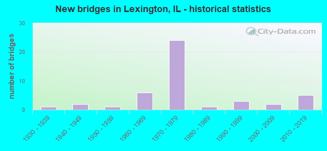
- New bridges - historical statistics
- 11930-1939
- 21940-1949
- 11950-1959
- 61960-1969
- 241970-1979
- 11980-1989
- 31990-1999
- 22000-2009
- 52010-2019

- Reconstructed bridges - Historical Statistics
- 11960-1969
- 01970-1979
- 01980-1989
- 31990-1999
- 12000-2009


- Bridge Condition - Deck
- 8.6%Very good
- 60.0%Good
- 31.4%Satisfactory

- Bridge Condition - Superstructure
- 11.4%Very good
- 62.9%Good
- 25.7%Satisfactory

- Bridge Condition - Substructure
- 17.1%Very good
- 57.1%Good
- 17.1%Satisfactory
- 8.6%Fair

- Bridge Condition - Channel
- 26.5%Very good
- 58.8%Good
- 14.7%Satisfactory

- Bridge Condition - Culverts
- 25.0%Very good
- 75.0%Good
Find on map >> Show street view
Structure Number: 570171, Location: 1 MI W OF LEXINGTON (Lat: 40.644989, Lng: -88.809081), Route carried "under" structure: Interstate 55, Year Built: 1973, Structure Length: 0. m, Average Daily Traffic: 22,000 (year 2021), Truck Traffic: 34%, Features Intersected: I-55, Facility Carried by Structure: FAS 473 CH 8
Minimum Vertical Clearance: 5.11m (16.77ft), Kilometerpoint: 286.793, Lanes on structure: 2, Lanes under structure: 4, Material/Design: Steel continuous, Design/Construction: Stringer/Multi-beam, Length of Maximum Span: 33.3m (109.3ft)
Find on map >> Show street view
Structure Number: 570172, Location: 1 MI NW OF LEXINGTON (Lat: 40.657381, Lng: -88.793331), Route carried "under" structure: Interstate 55, Year Built: 1973, Structure Length: 0. m, Average Daily Traffic: 22,000 (year 2021), Truck Traffic: 34%, Features Intersected: I-55, Facility Carried by Structure: FAS 356 CH 23
Minimum Vertical Clearance: 5.03m (16.50ft), Kilometerpoint: 288.902, Lanes on structure: 2, Lanes under structure: 4, Material/Design: Steel continuous, Design/Construction: Stringer/Multi-beam, Length of Maximum Span: 32.7m (107.3ft)
Find on map >> Show street view
Structure Number: 570175, Location: 2 MI N OF LEXINGTON (Lat: 40.682531, Lng: -88.760261), Route carried "under" structure: Interstate 55, Year Built: 1978, Structure Length: 0. m, Average Daily Traffic: 22,000 (year 2021), Truck Traffic: 34%, Features Intersected: I-55/OR 66A/CM&W RR, Facility Carried by Structure: TR 43
Minimum Vertical Clearance: 6.25m (20.51ft), Kilometerpoint: 293.198, Lanes on structure: 2, Lanes under structure: 6, Material/Design: Steel continuous, Design/Construction: Stringer/Multi-beam, Length of Maximum Span: 36.1m (118.4ft)
Find on map >> Show street view
Structure Number: 570175, Location: 2 MI N OF LEXINGTON (Lat: 40.682117, Lng: -88.760144), Route carried "under" structure: County highway , Year Built: 1978, Structure Length: 0. m, Average Daily Traffic: 2,400 (year 2020), Truck Traffic: 11%, Features Intersected: I-55/OR 66A/CM&W RR, Facility Carried by Structure: TR 43
Minimum Vertical Clearance: 6.10m (20.01ft), Kilometerpoint: 14.725, Lanes on structure: 2, Lanes under structure: 2, Material/Design: Steel continuous, Design/Construction: Stringer/Multi-beam, Length of Maximum Span: 36.1m (118.4ft)