Bridge Statistics for Lexington, North Carolina (NC)
Condition, Traffic, Stress, Structural Evaluation, Project Costs
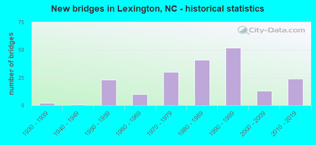
- New bridges - historical statistics
- 21930-1939
- 11940-1949
- 231950-1959
- 101960-1969
- 301970-1979
- 411980-1989
- 521990-1999
- 132000-2009
- 242010-2019
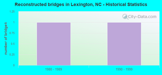
- Reconstructed bridges - Historical Statistics
- 11980-1989
- 11990-1999
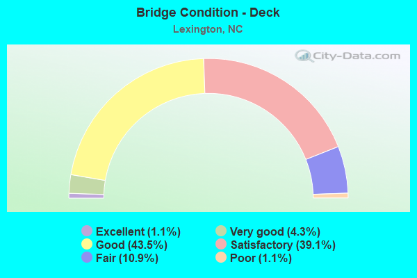
- Bridge Condition - Deck
- 1.1%Excellent
- 4.3%Very good
- 43.5%Good
- 39.1%Satisfactory
- 10.9%Fair
- 1.1%Poor
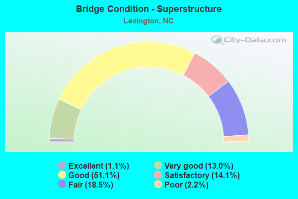
- Bridge Condition - Superstructure
- 1.1%Excellent
- 13.0%Very good
- 51.1%Good
- 14.1%Satisfactory
- 18.5%Fair
- 2.2%Poor
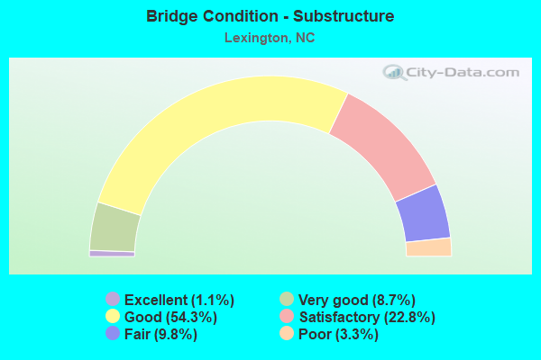
- Bridge Condition - Substructure
- 1.1%Excellent
- 8.7%Very good
- 54.3%Good
- 22.8%Satisfactory
- 9.8%Fair
- 3.3%Poor
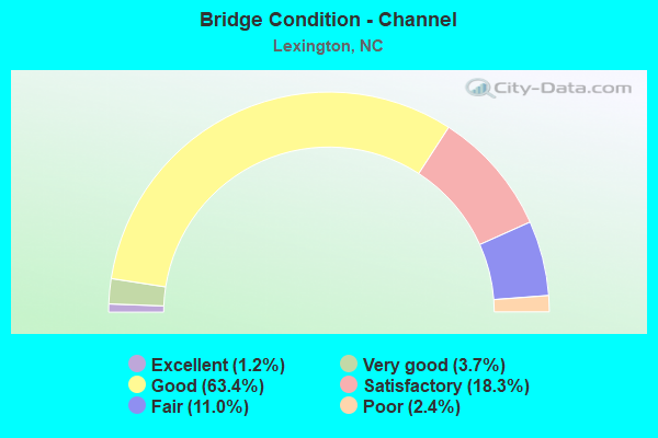
- Bridge Condition - Channel
- 1.2%Excellent
- 3.7%Very good
- 63.4%Good
- 18.3%Satisfactory
- 11.0%Fair
- 2.4%Poor
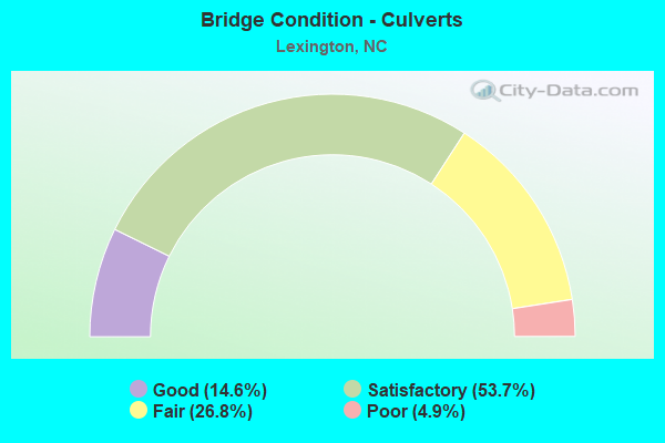
- Bridge Condition - Culverts
- 14.6%Good
- 53.7%Satisfactory
- 26.8%Fair
- 4.9%Poor
Find on map >> Show street view
Structure Number: 570556, Location: 50 FT. E. JCT. SR3117 (Lat: 35.804153, Lng: -80.308264), Route carried "on" structure: State highway 1385, Year Built: 1980, Status: Open, Structure Length: 0.88m (2.89ft), Average Daily Traffic: 150 (year 2002), Truck Traffic: 7%, Average Future Daily Traffic: 300 (year 2040), Design Load: HS 20+Mod, Features Intersected: BEAVERDAM CREEK
Minimum Vertical Clearance: 30+ m (98+ ft), Kilometerpoint: 0.000, Lanes on structure: 2, Owner: State Highway Agency, Approaching Roadway Width: 5.7m (18.7ft), Material/Design: Steel, Design/Construction: Culvert, Number Of Spans In Main Unit: 2, Length of Maximum Span: 3.6m (11.8ft)
Condition: Channel: Good, Culverts: Satisfactory, Operating Rating: 89.8 metric tons, Method Used To Determine Operating Rating: Load and Resistance Factor (LRFR), Inventory Rating: 89.8 metric tons, Method Used To Determine Inventory Rating: Load and Resistance Factor (LRFR), Structural Evaluation: Equal to present minimum criteria, Waterway Adequacy: Better than present minimum criteria, Approach Roadway Alignment: Equal to present desirable criteria, Designated Inspection Frequency: Every 24 months, Inspection Date: March 2021
Find on map >> Show street view
Structure Number: 570563, Location: .8 MI. S. JCT. SR 2123 (Lat: 35.842942, Lng: -80.192894), Route carried "on" structure: State highway 2005, Year Built: 2015, Status: Open, Structure Length: 16.58m (54.40ft), Average Daily Traffic: 1,400 (year 2017), Truck Traffic: 6%, Average Future Daily Traffic: 2,800 (year 2040), Design Load: HL 93, Features Intersected: NSRR & HAMBY CREEK
Minimum Vertical Clearance: 30+ m (98+ ft), Kilometerpoint: 0.000, Lanes on structure: 2, Owner: State Highway Agency, Approaching Roadway Width: 5.4m (17.7ft), Skew: 3 degrees, Material/Design: Prestressed concrete, Design/Construction: Stringer/Multi-beam, Number Of Spans In Main Unit: 6, Number Of Approach Spans: 1, Length of Maximum Span: 37.4m (122.7ft), Curb-To-Curb Width: 10.3m (33.8ft), Out-to-Out Width: 11.3m (37.1ft)
Condition: Deck: Very good, Superstructure: Very good, Substructure: Very good, Channel: Very good, Operating Rating: 66.2 metric tons, Method Used To Determine Operating Rating: Load and Resistance Factor (LRFR), Inventory Rating: 47.1 metric tons, Method Used To Determine Inventory Rating: Load and Resistance Factor (LRFR), Structural Evaluation: Equal to present desirable criteria, Deck Geometry: Somewhat better than minimum adequacy, Underclear: Meets minimum limits, Waterway Adequacy: Equal to present desirable criteria, Approach Roadway Alignment: Equal to present desirable criteria, Designated Inspection Frequency: Every 24 months, Inspection Date: Febuary 2021, Deck Structure Type: Concrete Cast-file-Place, Wearing Surface/Protective System: Wearing Surface: Monolithic Concrete
Find on map >> Show street view
Structure Number: 810059, Location: 0.1 MI. N. JCT. SR1135 (Lat: 35.943150, Lng: -79.902589), Route carried "on" structure: Interstate 85, Year Built: 1981, Status: Open, Structure Length: 9.14m (29.99ft), Average Daily Traffic: 34,000 (year 2018), Truck Traffic: 16%, Average Future Daily Traffic: 68,000 (year 2040), Design Load: HS 20+Mod, Features Intersected: DEEP RIVER
Minimum Vertical Clearance: 30+ m (98+ ft), Kilometerpoint: 35.052, Lanes on structure: 3, Base Highway Network: Yes (Inventory Route: 1, Subroute: 85), Owner: State Highway Agency, Approaching Roadway Width: 16.4m (53.8ft), Skew: 12 degrees, Material/Design: Prestressed concrete, Design/Construction: Stringer/Multi-beam, Number Of Spans In Main Unit: 5, Length of Maximum Span: 17.6m (57.7ft), Curb-To-Curb Width: 17.0m (55.8ft), Out-to-Out Width: 17.9m (58.7ft)
Condition: Deck: Good, Superstructure: Good, Substructure: Good, Channel: Good, Operating Rating: 89.8 metric tons, Method Used To Determine Operating Rating: Load Factor (LF), Inventory Rating: 44.4 metric tons, Method Used To Determine Inventory Rating: Load Factor (LF), Structural Evaluation: Better than present minimum criteria, Deck Geometry: Equal to present minimum criteria, Waterway Adequacy: Better than present minimum criteria, Approach Roadway Alignment: Equal to present desirable criteria, Designated Inspection Frequency: Every 24 months, Underwater Inspection Frequency: Every 60 months, Inspection Date: January 2022, Underwater Inspection Date: July 2018, Deck Structure Type: Concrete Cast-file-Place, Wearing Surface/Protective System: Wearing Surface: Monolithic Concrete
Find on map >> Show street view
Structure Number: 810545, Location: 2.0 MI. N. JCT. NC62 (Lat: 35.940419, Lng: -79.906331), Route carried "on" structure: Interstate 85, Year Built: 1981, Status: Open, Structure Length: 1.31m (4.30ft), Average Daily Traffic: 34,000 (year 2018), Truck Traffic: 16%, Average Future Daily Traffic: 68,000 (year 2040), Design Load: HS 20+Mod, Features Intersected: RICHLAND CREEK
Minimum Vertical Clearance: 30+ m (98+ ft), Kilometerpoint: 35.021, Lanes on structure: 3, Base Highway Network: Yes (Inventory Route: 1, Subroute: 85), Owner: State Highway Agency, Approaching Roadway Width: 13.4m (44.0ft), Skew: 10 degrees, Material/Design: Concrete continuous, Design/Construction: Culvert, Number Of Spans In Main Unit: 3, Length of Maximum Span: 4.2m (13.8ft)
Condition: Channel: Poor, Culverts: Poor, Operating Rating: 78.9 metric tons, Method Used To Determine Operating Rating: Load and Resistance Factor (LRFR), Inventory Rating: 60.7 metric tons, Method Used To Determine Inventory Rating: Load and Resistance Factor (LRFR), Structural Evaluation: Meets minimum limits, Waterway Adequacy: Better than present minimum criteria, Approach Roadway Alignment: Equal to present desirable criteria, Designated Inspection Frequency: Every 24 months, Underwater Inspection Frequency: Every 60 months, Inspection Date: January 2022, Underwater Inspection Date: January 2022
Find on map >> Show street view
Structure Number: 570001, Location: 2.4 MI. W. JCT. NC47 (Lat: 35.753822, Lng: -80.347661), Route carried "under" structure: Interstate 85, Year Built: 2012, Structure Length: 0. m, Average Daily Traffic: 36,500 (year 2015), Truck Traffic: 16%, Features Intersected: SR3159
Minimum Vertical Clearance: 5.48m (17.98ft), Kilometerpoint: 0.000, Lanes on structure: 5, Lanes under structure: 5, Material/Design: Prestressed concrete continuous, Design/Construction: Stringer/Multi-beam, Length of Maximum Span: 30.4m (99.7ft)
Find on map >> Show street view
Structure Number: 570001, Location: 2.4 MI. W. JCT. NC47 (Lat: 35.753822, Lng: -80.347661), Route carried "under" structure: Interstate 85, Year Built: 2012, Structure Length: 0. m, Average Daily Traffic: 39,750 (year 2018), Truck Traffic: 16%, Features Intersected: SR3159
Minimum Vertical Clearance: 5.63m (18.47ft), Kilometerpoint: 0.000, Lanes on structure: 5, Lanes under structure: 5, Material/Design: Prestressed concrete continuous, Design/Construction: Stringer/Multi-beam, Length of Maximum Span: 30.4m (99.7ft)
Find on map >> Show street view
Structure Number: 570027, Location: 0.5 MI. N. JCT. US29/70 (Lat: 35.835306, Lng: -80.253458), Route carried "under" structure: Interstate 85, Year Built: 2018, Structure Length: 0. m, Average Daily Traffic: 11,000 (year 2015), Truck Traffic: 12%, Features Intersected: NC8
Minimum Vertical Clearance: 5.25m (17.22ft), Kilometerpoint: 0.000, Lanes on structure: 4, Lanes under structure: 2, Material/Design: Prestressed concrete, Design/Construction: Stringer/Multi-beam, Length of Maximum Span: 21.9m (71.9ft)
Find on map >> Show street view
Structure Number: 570027, Location: 0.5 MI. N. JCT. US29/70 (Lat: 35.835306, Lng: -80.253458), Route carried "under" structure: Interstate 85, Year Built: 2018, Structure Length: 0. m, Average Daily Traffic: 11,000 (year 2015), Truck Traffic: 12%, Features Intersected: NC8
Minimum Vertical Clearance: 5.33m (17.49ft), Kilometerpoint: 0.000, Lanes on structure: 4, Lanes under structure: 2, Material/Design: Prestressed concrete, Design/Construction: Stringer/Multi-beam, Length of Maximum Span: 21.9m (71.9ft)
Find on map >> Show street view
Structure Number: 570035, Location: 0.1 MI.W.JCT.SR1223 (Lat: 35.778594, Lng: -80.317036), Route carried "under" structure: US 29, Year Built: 1961, Structure Length: 0. m, Average Daily Traffic: 15,250 (year 2019), Truck Traffic: 12%, Features Intersected: SR3165
Minimum Vertical Clearance: 5.33m (17.49ft), Kilometerpoint: 0.000, Lanes on structure: 2, Lanes under structure: 2, Material/Design: Prestressed concrete, Design/Construction: Stringer/Multi-beam, Length of Maximum Span: 16.1m (52.8ft)
Find on map >> Show street view
Structure Number: 570035, Location: 0.1 MI.W.JCT.SR1223 (Lat: 35.778594, Lng: -80.317036), Route carried "under" structure: US 29, Year Built: 1961, Structure Length: 0. m, Average Daily Traffic: 15,250 (year 2019), Truck Traffic: 12%, Features Intersected: SR3165
Minimum Vertical Clearance: 4.99m (16.37ft), Kilometerpoint: 0.000, Lanes on structure: 2, Lanes under structure: 2, Material/Design: Prestressed concrete, Design/Construction: Stringer/Multi-beam, Length of Maximum Span: 16.1m (52.8ft)
Find on map >> Show street view
Structure Number: 570037, Location: 0.1 MI.W.JCT.SR1228 (Lat: 35.787561, Lng: -80.305117), Route carried "under" structure: Business Interstate 85, Year Built: 1961, Structure Length: 0. m, Average Daily Traffic: 14,000 (year 2019), Truck Traffic: 12%, Features Intersected: SR1297
Minimum Vertical Clearance: 5.06m (16.60ft), Kilometerpoint: 25.908, Lanes on structure: 2, Lanes under structure: 2, Material/Design: Prestressed concrete, Design/Construction: Stringer/Multi-beam, Length of Maximum Span: 14.9m (48.9ft)
Find on map >> Show street view
Structure Number: 570037, Location: 0.1 MI.W.JCT.SR1228 (Lat: 35.787561, Lng: -80.305117), Route carried "under" structure: Business Interstate 85, Year Built: 1961, Structure Length: 0. m, Average Daily Traffic: 17,000 (year 2019), Truck Traffic: 12%, Features Intersected: SR1297
Minimum Vertical Clearance: 5.51m (18.08ft), Kilometerpoint: 25.908, Lanes on structure: 2, Lanes under structure: 2, Material/Design: Prestressed concrete, Design/Construction: Stringer/Multi-beam, Length of Maximum Span: 14.9m (48.9ft)
Find on map >> Show street view
Structure Number: 570039, Location: 1.1 MI. S. JCT. NC8 (Lat: 35.831639, Lng: -80.270167), Route carried "under" structure: Business Interstate 85, Year Built: 2014, Structure Length: 0. m, Average Daily Traffic: 7,500 (year 2018), Truck Traffic: 12%, Features Intersected: US64, RAMP
Minimum Vertical Clearance: 5.48m (17.98ft), Kilometerpoint: 0.000, Lanes on structure: 3, Lanes under structure: 2, Material/Design: Prestressed concrete continuous, Design/Construction: Stringer/Multi-beam, Length of Maximum Span: 31.6m (103.7ft)
Find on map >> Show street view
Structure Number: 570039, Location: 1.1 MI. S. JCT. NC8 (Lat: 35.831639, Lng: -80.270167), Route carried "under" structure: Business Interstate 85, Year Built: 2014, Structure Length: 0. m, Average Daily Traffic: 7,500 (year 2018), Truck Traffic: 12%, Features Intersected: US64, RAMP
Minimum Vertical Clearance: 5.30m (17.39ft), Kilometerpoint: 0.000, Lanes on structure: 3, Lanes under structure: 3, Material/Design: Prestressed concrete continuous, Design/Construction: Stringer/Multi-beam, Length of Maximum Span: 31.6m (103.7ft)
Find on map >> Show street view
Structure Number: 570044, Location: 0.3 MI. S. JCT. SR1430 (Lat: 35.851100, Lng: -80.326317), Route carried "under" structure: US 64, Year Built: 1952, Structure Length: 0. m, Average Daily Traffic: 10,000 (year 2015), Truck Traffic: 12%, Features Intersected: NC150
Minimum Vertical Clearance: 4.26m (13.98ft), Kilometerpoint: 0.000, Lanes on structure: 2, Lanes under structure: 2, Material/Design: Concrete, Design/Construction: Tee Beam, Length of Maximum Span: 14.9m (48.9ft)
Find on map >> Show street view
Structure Number: 570053, Location: 0.7 MI. W. JCT. SR2726 (Lat: 35.833919, Lng: -80.238178), Route carried "under" structure: State highway 3346, Year Built: 1951, Structure Length: 0. m, Average Daily Traffic: 2,500 (year 2018), Truck Traffic: 12%, Features Intersected: US64W
Minimum Vertical Clearance: 4.45m (14.60ft), Kilometerpoint: 0.000, Lanes on structure: 2, Lanes under structure: 2, Material/Design: Concrete, Design/Construction: Tee Beam, Length of Maximum Span: 13.4m (44.0ft)
Find on map >> Show street view
Structure Number: 570053, Location: 0.7 MI. W. JCT. SR2726 (Lat: 35.833919, Lng: -80.238178), Route carried "under" structure: State highway 3346, Year Built: 1951, Structure Length: 0. m, Average Daily Traffic: 2,500 (year 2018), Truck Traffic: 12%, Features Intersected: US64W
Minimum Vertical Clearance: 4.42m (14.50ft), Kilometerpoint: 0.000, Lanes on structure: 2, Lanes under structure: 2, Material/Design: Concrete, Design/Construction: Tee Beam, Length of Maximum Span: 13.4m (44.0ft)
Find on map >> Show street view
Structure Number: 57006, Location: 0.2 MI. W. JCT. SR1298 (Lat: 35.801333, Lng: -80.292392), Route carried "under" structure: Interstate 85, Year Built: 1993, Structure Length: 0. m, Average Daily Traffic: 19,500 (year 2019), Truck Traffic: 12%, Features Intersected: SR3346
Minimum Vertical Clearance: 5.58m (18.31ft), Kilometerpoint: 26.304, Lanes on structure: 4, Lanes under structure: 4, Material/Design: Steel, Design/Construction: Stringer/Multi-beam, Length of Maximum Span: 38.4m (126.0ft)
Find on map >> Show street view
Structure Number: 57006, Location: 0.2 MI. W. JCT. SR1298 (Lat: 35.801333, Lng: -80.292392), Route carried "under" structure: Interstate 85, Year Built: 1993, Structure Length: 0. m, Average Daily Traffic: 19,500 (year 2019), Truck Traffic: 12%, Features Intersected: SR3346
Minimum Vertical Clearance: 5.20m (17.06ft), Kilometerpoint: 26.304, Lanes on structure: 4, Lanes under structure: 3, Material/Design: Steel, Design/Construction: Stringer/Multi-beam, Length of Maximum Span: 38.4m (126.0ft)
Find on map >> Show street view
Structure Number: 570067, Location: 0.4 MI. S. JCT. US64 (Lat: 35.826181, Lng: -80.275139), Route carried "under" structure: State highway 1192, Year Built: 1950, Structure Length: 0. m, Average Daily Traffic: 6,400 (year 2017), Truck Traffic: 7%, Features Intersected: I85N.BUS,US29,US70
Minimum Vertical Clearance: 5.01m (16.44ft), Kilometerpoint: 0.000, Lanes on structure: 2, Lanes under structure: 2, Material/Design: Steel, Design/Construction: Stringer/Multi-beam, Length of Maximum Span: 13.4m (44.0ft)
Find on map >> Show street view
Structure Number: 570068, Location: 0.4 MI. S. JCT. US64 (Lat: 35.826219, Lng: -80.275311), Route carried "under" structure: State highway 1192, Year Built: 1950, Structure Length: 0. m, Average Daily Traffic: 7,100 (year 2018), Truck Traffic: 7%, Features Intersected: I85S.BUS,US29,US70
Minimum Vertical Clearance: 4.44m (14.57ft), Kilometerpoint: 0.000, Lanes on structure: 2, Lanes under structure: 2, Material/Design: Steel, Design/Construction: Stringer/Multi-beam, Length of Maximum Span: 13.4m (44.0ft)
Find on map >> Show street view
Structure Number: 570074, Location: 0.8 MI. S. JCT. NC8 (Lat: 35.833756, Lng: -80.265636), Route carried "under" structure: State highway 1242, Year Built: 2008, Structure Length: 0. m, Average Daily Traffic: 4,300 (year 2018), Truck Traffic: 6%, Features Intersected: I85BUS, US29, US70
Minimum Vertical Clearance: 4.90m (16.08ft), Kilometerpoint: 0.000, Lanes on structure: 3, Lanes under structure: 3, Material/Design: Steel, Design/Construction: Stringer/Multi-beam, Length of Maximum Span: 40.5m (132.9ft)
Find on map >> Show street view
Structure Number: 570076, Location: .8 MI. S. JCT. NC8 (Lat: 35.833889, Lng: -80.265647), Route carried "under" structure: State highway 1242, Year Built: 2006, Structure Length: 0. m, Average Daily Traffic: 4,300 (year 2016), Truck Traffic: 7%, Features Intersected: I85BUSS,US29S,US70
Minimum Vertical Clearance: 5.88m (19.29ft), Kilometerpoint: 0.000, Lanes on structure: 2, Lanes under structure: 3, Material/Design: Steel, Design/Construction: Stringer/Multi-beam, Length of Maximum Span: 40.8m (133.9ft)
Find on map >> Show street view
Structure Number: 57008, Location: 0.1 MI.E.JCT.US29/70BUS (Lat: 35.833239, Lng: -80.237247), Route carried "under" structure: Interstate 85, Year Built: 1951, Structure Length: 0. m, Average Daily Traffic: 11,750 (year 2018), Truck Traffic: 12%, Features Intersected: US64 WBL
Minimum Vertical Clearance: 4.62m (15.16ft), Kilometerpoint: 0.000, Lanes on structure: 2, Lanes under structure: 2, Material/Design: Concrete, Design/Construction: Tee Beam, Length of Maximum Span: 15.2m (49.9ft)
Find on map >> Show street view
Structure Number: 570092, Location: 0.2 MI. N. JCT. SR1265 (Lat: 35.780278, Lng: -80.259967), Route carried "under" structure: Interstate 85, Year Built: 1980, Structure Length: 0. m, Average Daily Traffic: 29,000 (year 2019), Truck Traffic: 16%, Features Intersected: NC8
Minimum Vertical Clearance: 5.63m (18.47ft), Kilometerpoint: 27.889, Lanes on structure: 4, Lanes under structure: 4, Material/Design: Steel continuous, Design/Construction: Stringer/Multi-beam, Length of Maximum Span: 41.7m (136.8ft)
Find on map >> Show street view
Structure Number: 570092, Location: 0.2 MI. N. JCT. SR1265 (Lat: 35.780278, Lng: -80.259967), Route carried "under" structure: Interstate 85, Year Built: 1980, Structure Length: 0. m, Average Daily Traffic: 29,000 (year 2019), Truck Traffic: 16%, Features Intersected: NC8
Minimum Vertical Clearance: 5.82m (19.09ft), Kilometerpoint: 27.889, Lanes on structure: 4, Lanes under structure: 4, Material/Design: Steel continuous, Design/Construction: Stringer/Multi-beam, Length of Maximum Span: 41.7m (136.8ft)
Find on map >> Show street view
Structure Number: 570118, Location: 0.8 MI.N.JCT.NC8 (Lat: 35.833306, Lng: -80.239844), Route carried "under" structure: US 3346, Year Built: 1950, Structure Length: 0. m, Average Daily Traffic: 6,000 (year 2016), Truck Traffic: 12%, Features Intersected: I85NBUS,US29,US70
Minimum Vertical Clearance: 4.57m (14.99ft), Kilometerpoint: 0.000, Lanes on structure: 2, Lanes under structure: 2, Material/Design: Steel, Design/Construction: Stringer/Multi-beam, Length of Maximum Span: 19.5m (64.0ft)
Find on map >> Show street view
Structure Number: 570118, Location: 0.8 MI.N.JCT.NC8 (Lat: 35.833306, Lng: -80.239844), Route carried "under" structure: US 3346, Year Built: 1950, Structure Length: 0. m, Average Daily Traffic: 6,000 (year 2016), Truck Traffic: 12%, Features Intersected: I85NBUS,US29,US70
Minimum Vertical Clearance: 4.39m (14.40ft), Kilometerpoint: 0.000, Lanes on structure: 2, Lanes under structure: 2, Material/Design: Steel, Design/Construction: Stringer/Multi-beam, Length of Maximum Span: 19.5m (64.0ft)
Find on map >> Show street view
Structure Number: 570137, Location: 0.7 MI.S.JCT.SR1224 (Lat: 35.771756, Lng: -80.324122), Route carried "under" structure: Interstate 85, Year Built: 1977, Structure Length: 0. m, Average Daily Traffic: 22,500 (year 2015), Truck Traffic: 16%, Features Intersected: I85B,US29,US70RAMP
Minimum Vertical Clearance: 5.76m (18.90ft), Kilometerpoint: 26.670, Lanes on structure: 2, Lanes under structure: 3, Material/Design: Steel, Design/Construction: Stringer/Multi-beam, Length of Maximum Span: 40.8m (133.9ft)
Find on map >> Show street view
Structure Number: 570137, Location: 0.7 MI.S.JCT.SR1224 (Lat: 35.771756, Lng: -80.324122), Route carried "under" structure: Interstate 85, Year Built: 1977, Structure Length: 0. m, Average Daily Traffic: 22,500 (year 2015), Truck Traffic: 16%, Features Intersected: I85B,US29,US70RAMP
Minimum Vertical Clearance: 6.43m (21.10ft), Kilometerpoint: 26.670, Lanes on structure: 2, Lanes under structure: 3, Material/Design: Steel, Design/Construction: Stringer/Multi-beam, Length of Maximum Span: 40.8m (133.9ft)
Find on map >> Show street view
Structure Number: 570146, Location: 0.5 MI. E. JCT. US29 & 70 (Lat: 35.773906, Lng: -80.314389), Route carried "under" structure: Interstate 85, Year Built: 1977, Structure Length: 0. m, Average Daily Traffic: 22,500 (year 2015), Truck Traffic: 16%, Features Intersected: NC47
Minimum Vertical Clearance: 5.21m (17.09ft), Kilometerpoint: 26.844, Lanes on structure: 2, Lanes under structure: 3, Material/Design: Steel, Design/Construction: Stringer/Multi-beam, Length of Maximum Span: 31.3m (102.7ft)
Find on map >> Show street view
Structure Number: 570146, Location: 0.5 MI. E. JCT. US29 & 70 (Lat: 35.773906, Lng: -80.314389), Route carried "under" structure: Interstate 85, Year Built: 1977, Structure Length: 0. m, Average Daily Traffic: 22,500 (year 2015), Truck Traffic: 16%, Features Intersected: NC47
Minimum Vertical Clearance: 4.99m (16.37ft), Kilometerpoint: 26.844, Lanes on structure: 2, Lanes under structure: 3, Material/Design: Steel, Design/Construction: Stringer/Multi-beam, Length of Maximum Span: 31.3m (102.7ft)
Find on map >> Show street view
Structure Number: 570163, Location: 0.1 MI. N. JCT. SR1266 (Lat: 35.776603, Lng: -80.278725), Route carried "under" structure: Interstate 85, Year Built: 1978, Structure Length: 0. m, Average Daily Traffic: 24,000 (year 2015), Truck Traffic: 16%, Features Intersected: SR1104
Minimum Vertical Clearance: 5.54m (18.18ft), Kilometerpoint: 27.554, Lanes on structure: 2, Lanes under structure: 3, Material/Design: Steel, Design/Construction: Stringer/Multi-beam, Length of Maximum Span: 39.0m (128.0ft)
Find on map >> Show street view
Structure Number: 570163, Location: 0.1 MI. N. JCT. SR1266 (Lat: 35.776603, Lng: -80.278725), Route carried "under" structure: Interstate 85, Year Built: 1978, Structure Length: 0. m, Average Daily Traffic: 24,000 (year 2015), Truck Traffic: 16%, Features Intersected: SR1104
Minimum Vertical Clearance: 5.21m (17.09ft), Kilometerpoint: 27.554, Lanes on structure: 2, Lanes under structure: 3, Material/Design: Steel, Design/Construction: Stringer/Multi-beam, Length of Maximum Span: 39.0m (128.0ft)
Find on map >> Show street view
Structure Number: 570174, Location: 2.0 MI. W. JCT. SR2250 (Lat: 35.795147, Lng: -80.216964), Route carried "under" structure: Interstate 85, Year Built: 1978, Structure Length: 0. m, Average Daily Traffic: 26,000 (year 2015), Truck Traffic: 16%, Features Intersected: SR2205
Minimum Vertical Clearance: 5.45m (17.88ft), Kilometerpoint: 28.682, Lanes on structure: 2, Lanes under structure: 3, Material/Design: Steel continuous, Design/Construction: Stringer/Multi-beam, Length of Maximum Span: 39.0m (128.0ft)
Find on map >> Show street view
Structure Number: 570174, Location: 2.0 MI. W. JCT. SR2250 (Lat: 35.795147, Lng: -80.216964), Route carried "under" structure: Interstate 85, Year Built: 1978, Structure Length: 0. m, Average Daily Traffic: 26,000 (year 2015), Truck Traffic: 16%, Features Intersected: SR2205
Minimum Vertical Clearance: 5.36m (17.59ft), Kilometerpoint: 28.682, Lanes on structure: 2, Lanes under structure: 3, Material/Design: Steel continuous, Design/Construction: Stringer/Multi-beam, Length of Maximum Span: 39.0m (128.0ft)
Find on map >> Show street view
Structure Number: 570181, Location: 0.7 MI. S. JCT. SR2010 (Lat: 35.809494, Lng: -80.182125), Route carried "under" structure: US 64, Year Built: 1978, Structure Length: 0. m, Average Daily Traffic: 6,500 (year 2015), Truck Traffic: 14%, Features Intersected: I85 NBL
Minimum Vertical Clearance: 5.39m (17.68ft), Kilometerpoint: 0.000, Lanes on structure: 3, Lanes under structure: 2, Material/Design: Steel continuous, Design/Construction: Stringer/Multi-beam, Length of Maximum Span: 37.7m (123.7ft)
Find on map >> Show street view
Structure Number: 570181, Location: 0.7 MI. S. JCT. SR2010 (Lat: 35.809494, Lng: -80.182125), Route carried "under" structure: US 64, Year Built: 1978, Structure Length: 0. m, Average Daily Traffic: 6,500 (year 2015), Truck Traffic: 14%, Features Intersected: I85 NBL
Minimum Vertical Clearance: 4.95m (16.24ft), Kilometerpoint: 0.000, Lanes on structure: 3, Lanes under structure: 3, Material/Design: Steel continuous, Design/Construction: Stringer/Multi-beam, Length of Maximum Span: 37.7m (123.7ft)
Find on map >> Show street view
Structure Number: 570182, Location: 0.7 MI. S. JCT. SR2010 (Lat: 35.809614, Lng: -80.182472), Route carried "under" structure: US 64, Year Built: 1978, Structure Length: 0. m, Average Daily Traffic: 7,000 (year 2017), Truck Traffic: 14%, Features Intersected: I85S
Minimum Vertical Clearance: 5.38m (17.65ft), Kilometerpoint: 0.000, Lanes on structure: 3, Lanes under structure: 3, Material/Design: Steel continuous, Design/Construction: Stringer/Multi-beam, Length of Maximum Span: 37.7m (123.7ft)
Find on map >> Show street view
Structure Number: 570182, Location: 0.7 MI. S. JCT. SR2010 (Lat: 35.809614, Lng: -80.182472), Route carried "under" structure: US 64, Year Built: 1978, Structure Length: 0. m, Average Daily Traffic: 7,000 (year 2017), Truck Traffic: 14%, Features Intersected: I85S
Minimum Vertical Clearance: 4.95m (16.24ft), Kilometerpoint: 0.000, Lanes on structure: 3, Lanes under structure: 3, Material/Design: Steel continuous, Design/Construction: Stringer/Multi-beam, Length of Maximum Span: 37.7m (123.7ft)
Find on map >> Show street view
Structure Number: 570424, Location: 0.4 MI. E. JCT. SR2212 (Lat: 35.814439, Lng: -80.246533), Route carried "under" structure: State highway 8, Year Built: 2016, Structure Length: 0. m, Average Daily Traffic: 12,500 (year 2018), Truck Traffic: 6%, Features Intersected: SR1243
Minimum Vertical Clearance: 4.72m (15.49ft), Kilometerpoint: 0.000, Lanes on structure: 2, Lanes under structure: 2, Material/Design: Prestressed concrete continuous, Design/Construction: Stringer/Multi-beam, Length of Maximum Span: 24.6m (80.7ft)
Find on map >> Show street view
Structure Number: 570473, Location: 0.1 MI. E. JCT. SR2014 (Lat: 35.817997, Lng: -80.174233), Route carried "under" structure: Interstate 85, Year Built: 1981, Structure Length: 0. m, Average Daily Traffic: 26,000 (year 2015), Truck Traffic: 23%, Features Intersected: SR2010
Minimum Vertical Clearance: 5.60m (18.37ft), Kilometerpoint: 29.505, Lanes on structure: 2, Lanes under structure: 3, Material/Design: Steel continuous, Design/Construction: Stringer/Multi-beam, Length of Maximum Span: 46.0m (150.9ft)
Find on map >> Show street view
Structure Number: 570473, Location: 0.1 MI. E. JCT. SR2014 (Lat: 35.817997, Lng: -80.174233), Route carried "under" structure: Interstate 85, Year Built: 1981, Structure Length: 0. m, Average Daily Traffic: 26,000 (year 2015), Truck Traffic: 23%, Features Intersected: SR2010
Minimum Vertical Clearance: 5.36m (17.59ft), Kilometerpoint: 29.505, Lanes on structure: 2, Lanes under structure: 3, Material/Design: Steel continuous, Design/Construction: Stringer/Multi-beam, Length of Maximum Span: 46.0m (150.9ft)
Find on map >> Show street view
Structure Number: 570511, Location: 0.1 MI. W. JCT. SR2940 (Lat: 35.919258, Lng: -80.232786), Route carried "under" structure: US 52, Year Built: 1988, Structure Length: 0. m, Average Daily Traffic: 16,250 (year 2019), Truck Traffic: 12%, Features Intersected: SR1822
Minimum Vertical Clearance: 5.13m (16.83ft), Kilometerpoint: 29.230, Lanes on structure: 2, Lanes under structure: 2, Material/Design: Prestressed concrete, Design/Construction: Stringer/Multi-beam, Length of Maximum Span: 25.2m (82.7ft)
Find on map >> Show street view
Structure Number: 570511, Location: 0.1 MI. W. JCT. SR2940 (Lat: 35.919258, Lng: -80.232786), Route carried "under" structure: US 52, Year Built: 1988, Structure Length: 0. m, Average Daily Traffic: 16,250 (year 2019), Truck Traffic: 12%, Features Intersected: SR1822
Minimum Vertical Clearance: 5.20m (17.06ft), Kilometerpoint: 29.230, Lanes on structure: 2, Lanes under structure: 2, Material/Design: Prestressed concrete, Design/Construction: Stringer/Multi-beam, Length of Maximum Span: 25.2m (82.7ft)
Find on map >> Show street view
Structure Number: 570512, Location: 0.1 MI. E. JCT. SR1833 (Lat: 35.902342, Lng: -80.234139), Route carried "under" structure: US 52, Year Built: 1988, Structure Length: 0. m, Average Daily Traffic: 13,000 (year 2015), Truck Traffic: 12%, Features Intersected: SR1821
Minimum Vertical Clearance: 5.05m (16.57ft), Kilometerpoint: 0.000, Lanes on structure: 2, Lanes under structure: 2, Material/Design: Prestressed concrete, Design/Construction: Stringer/Multi-beam, Length of Maximum Span: 23.7m (77.8ft)
Find on map >> Show street view
Structure Number: 570512, Location: 0.1 MI. E. JCT. SR1833 (Lat: 35.902342, Lng: -80.234139), Route carried "under" structure: US 52, Year Built: 1988, Structure Length: 0. m, Average Daily Traffic: 13,000 (year 2015), Truck Traffic: 16%, Features Intersected: SR1821
Minimum Vertical Clearance: 5.38m (17.65ft), Kilometerpoint: 0.000, Lanes on structure: 2, Lanes under structure: 2, Material/Design: Prestressed concrete, Design/Construction: Stringer/Multi-beam, Length of Maximum Span: 23.7m (77.8ft)
Find on map >> Show street view
Structure Number: 570513, Location: 0.5 MI. N. JCT. SR1841 (Lat: 35.873136, Lng: -80.248125), Route carried "under" structure: US 52, Year Built: 1989, Structure Length: 0. m, Average Daily Traffic: 13,750 (year 2019), Truck Traffic: 12%, Features Intersected: NC8
Minimum Vertical Clearance: 5.38m (17.65ft), Kilometerpoint: 28.407, Lanes on structure: 4, Lanes under structure: 3, Material/Design: Steel, Design/Construction: Stringer/Multi-beam, Length of Maximum Span: 28.9m (94.8ft)
Find on map >> Show street view
Structure Number: 570513, Location: 0.5 MI. N. JCT. SR1841 (Lat: 35.873136, Lng: -80.248125), Route carried "under" structure: US 52, Year Built: 1989, Structure Length: 0. m, Average Daily Traffic: 13,750 (year 2019), Truck Traffic: 12%, Features Intersected: NC8
Minimum Vertical Clearance: 5.28m (17.32ft), Kilometerpoint: 28.133, Lanes on structure: 4, Lanes under structure: 3, Material/Design: Steel, Design/Construction: Stringer/Multi-beam, Length of Maximum Span: 28.9m (94.8ft)
Find on map >> Show street view
Structure Number: 570514, Location: 0.1 MI. E. JCT. SR1833 (Lat: 35.887772, Lng: -80.231089), Route carried "under" structure: US 52, Year Built: 1989, Structure Length: 0. m, Average Daily Traffic: 16,250 (year 2019), Truck Traffic: 12%, Features Intersected: SR1836
Minimum Vertical Clearance: 5.18m (16.99ft), Kilometerpoint: 28.621, Lanes on structure: 2, Lanes under structure: 2, Material/Design: Prestressed concrete, Design/Construction: Stringer/Multi-beam, Length of Maximum Span: 22.2m (72.8ft)
Find on map >> Show street view
Structure Number: 570514, Location: 0.1 MI. E. JCT. SR1833 (Lat: 35.887772, Lng: -80.231089), Route carried "under" structure: US 52, Year Built: 1989, Structure Length: 0. m, Average Daily Traffic: 16,250 (year 2019), Truck Traffic: 12%, Features Intersected: SR1836
Minimum Vertical Clearance: 5.23m (17.16ft), Kilometerpoint: 28.621, Lanes on structure: 2, Lanes under structure: 2, Material/Design: Prestressed concrete, Design/Construction: Stringer/Multi-beam, Length of Maximum Span: 22.2m (72.8ft)
Find on map >> Show street view
Structure Number: 570515, Location: 1.2 MI. S. JCT. SR1506 (Lat: 35.937742, Lng: -80.233978), Route carried "under" structure: State highway 2932, Year Built: 1990, Structure Length: 0. m, Average Daily Traffic: 7,000 (year 2017), Truck Traffic: 7%, Features Intersected: US52, NC8 SBL
Minimum Vertical Clearance: 6.95m (22.80ft), Kilometerpoint: 0.000, Lanes on structure: 3, Lanes under structure: 2, Material/Design: Steel, Design/Construction: Stringer/Multi-beam, Length of Maximum Span: 37.7m (123.7ft)
Find on map >> Show street view
Structure Number: 570515, Location: 1.2 MI. S. JCT. SR1506 (Lat: 35.937742, Lng: -80.233978), Route carried "under" structure: State highway 2932, Year Built: 1990, Structure Length: 0. m, Average Daily Traffic: 7,000 (year 2017), Truck Traffic: 7%, Features Intersected: US52, NC8 SBL
Minimum Vertical Clearance: 7.62m (25.00ft), Kilometerpoint: 0.000, Lanes on structure: 3, Lanes under structure: 2, Material/Design: Steel, Design/Construction: Stringer/Multi-beam, Length of Maximum Span: 37.7m (123.7ft)
Find on map >> Show street view
Structure Number: 570522, Location: 0.9 MI. W. JCT. NC8 (Lat: 35.867856, Lng: -80.265647), Route carried "under" structure: US 52, Year Built: 1991, Structure Length: 0. m, Average Daily Traffic: 13,750 (year 2019), Truck Traffic: 16%, Features Intersected: SR1457
Minimum Vertical Clearance: 5.71m (18.73ft), Kilometerpoint: 27.859, Lanes on structure: 2, Lanes under structure: 2, Material/Design: Prestressed concrete, Design/Construction: Stringer/Multi-beam, Length of Maximum Span: 22.5m (73.8ft)
Find on map >> Show street view
Structure Number: 570522, Location: 0.9 MI. W. JCT. NC8 (Lat: 35.867856, Lng: -80.265647), Route carried "under" structure: US 52, Year Built: 1991, Structure Length: 0. m, Average Daily Traffic: 13,750 (year 2019), Truck Traffic: 16%, Features Intersected: SR1457
Minimum Vertical Clearance: 5.66m (18.57ft), Kilometerpoint: 27.859, Lanes on structure: 2, Lanes under structure: 2, Material/Design: Prestressed concrete, Design/Construction: Stringer/Multi-beam, Length of Maximum Span: 22.5m (73.8ft)
Find on map >> Show street view
Structure Number: 570526, Location: 0.9 MI. N. JCT. SR1192 (Lat: 35.817917, Lng: -80.284522), Route carried "under" structure: US 52, Year Built: 1992, Structure Length: 0. m, Average Daily Traffic: 12,750 (year 2018), Truck Traffic: 16%, Features Intersected: I85 BUS,US29,US70
Minimum Vertical Clearance: 6.17m (20.24ft), Kilometerpoint: 0.000, Lanes on structure: 2, Lanes under structure: 2, Material/Design: Steel, Design/Construction: Stringer/Multi-beam, Length of Maximum Span: 32.0m (105.0ft)
Find on map >> Show street view
Structure Number: 570526, Location: 0.9 MI. N. JCT. SR1192 (Lat: 35.817917, Lng: -80.284522), Route carried "under" structure: US 52, Year Built: 1992, Structure Length: 0. m, Average Daily Traffic: 12,750 (year 2018), Truck Traffic: 16%, Features Intersected: I85 BUS,US29,US70
Minimum Vertical Clearance: 5.41m (17.75ft), Kilometerpoint: 0.000, Lanes on structure: 2, Lanes under structure: 2, Material/Design: Steel, Design/Construction: Stringer/Multi-beam, Length of Maximum Span: 32.0m (105.0ft)
Find on map >> Show street view
Structure Number: 570527, Location: 0.6 MI. S. JCT. US64 (Lat: 35.827872, Lng: -80.283722), Route carried "under" structure: State highway 1192, Year Built: 1992, Structure Length: 0. m, Average Daily Traffic: 7,100 (year 2018), Truck Traffic: 7%, Features Intersected: I285S,US52S
Minimum Vertical Clearance: 5.05m (16.57ft), Kilometerpoint: 0.000, Lanes on structure: 2, Lanes under structure: 2, Material/Design: Prestressed concrete, Design/Construction: Stringer/Multi-beam, Length of Maximum Span: 21.3m (69.9ft)
Find on map >> Show street view
Structure Number: 570528, Location: 0.6 MI. S. JCT. US64 (Lat: 35.827856, Lng: -80.283414), Route carried "under" structure: State highway 1192, Year Built: 1992, Structure Length: 0. m, Average Daily Traffic: 7,100 (year 2018), Truck Traffic: 7%, Features Intersected: I285,US52N
Minimum Vertical Clearance: 6.24m (20.47ft), Kilometerpoint: 0.000, Lanes on structure: 2, Lanes under structure: 2, Material/Design: Prestressed concrete, Design/Construction: Stringer/Multi-beam, Length of Maximum Span: 21.3m (69.9ft)
Find on map >> Show street view
Structure Number: 570529, Location: 0.6 MI. N. JCT. SR1192 (Lat: 35.836503, Lng: -80.282756), Route carried "under" structure: US 64, Year Built: 1992, Structure Length: 0. m, Average Daily Traffic: 9,500 (year 2017), Truck Traffic: 12%, Features Intersected: US52S
Minimum Vertical Clearance: 6.27m (20.57ft), Kilometerpoint: 0.000, Lanes on structure: 2, Lanes under structure: 3, Material/Design: Steel, Design/Construction: Stringer/Multi-beam, Length of Maximum Span: 31.3m (102.7ft)
Find on map >> Show street view
Structure Number: 570529, Location: 0.6 MI. N. JCT. SR1192 (Lat: 35.836503, Lng: -80.282756), Route carried "under" structure: US 64, Year Built: 1992, Structure Length: 0. m, Average Daily Traffic: 9,500 (year 2017), Truck Traffic: 12%, Features Intersected: US52S
Minimum Vertical Clearance: 6.04m (19.82ft), Kilometerpoint: 0.000, Lanes on structure: 2, Lanes under structure: 3, Material/Design: Steel, Design/Construction: Stringer/Multi-beam, Length of Maximum Span: 31.3m (102.7ft)
Find on map >> Show street view
Structure Number: 57053, Location: 0.6 MI. N. JCT. SR1192 (Lat: 35.836361, Lng: -80.282461), Route carried "under" structure: US 64, Year Built: 1992, Structure Length: 0. m, Average Daily Traffic: 9,500 (year 2017), Truck Traffic: 12%, Features Intersected: US52N
Minimum Vertical Clearance: 5.02m (16.47ft), Kilometerpoint: 0.000, Lanes on structure: 2, Lanes under structure: 3, Material/Design: Steel, Design/Construction: Stringer/Multi-beam, Length of Maximum Span: 31.6m (103.7ft)
Find on map >> Show street view
Structure Number: 570531, Location: 0.9 MI. N. JCT. US64 (Lat: 35.848553, Lng: -80.278289), Route carried "under" structure: State highway 1242, Year Built: 1992, Structure Length: 0. m, Average Daily Traffic: 5,800 (year 2016), Truck Traffic: 7%, Features Intersected: US52 SBL
Minimum Vertical Clearance: 4.84m (15.88ft), Kilometerpoint: 0.000, Lanes on structure: 2, Lanes under structure: 2, Material/Design: Prestressed concrete, Design/Construction: Stringer/Multi-beam, Length of Maximum Span: 25.6m (84.0ft)
Find on map >> Show street view
Structure Number: 570532, Location: 0.9 MI. N. JCT. US64 (Lat: 35.848267, Lng: -80.278161), Route carried "under" structure: State highway 1242, Year Built: 1992, Structure Length: 0. m, Average Daily Traffic: 5,800 (year 2016), Truck Traffic: 7%, Features Intersected: US52N
Minimum Vertical Clearance: 4.71m (15.45ft), Kilometerpoint: 0.000, Lanes on structure: 2, Lanes under structure: 2, Material/Design: Prestressed concrete, Design/Construction: Stringer/Multi-beam, Length of Maximum Span: 25.6m (84.0ft)
Find on map >> Show street view
Structure Number: 570535, Location: 0.1 MI. S. JCT. NC8 (Lat: 35.872864, Lng: -80.249367), Route carried "under" structure: US 52, Year Built: 1992, Structure Length: 0. m, Average Daily Traffic: 13,750 (year 2019), Truck Traffic: 16%, Features Intersected: SR1417
Minimum Vertical Clearance: 7.44m (24.41ft), Kilometerpoint: 0.000, Lanes on structure: 2, Lanes under structure: 3, Material/Design: Steel, Design/Construction: Stringer/Multi-beam, Length of Maximum Span: 26.5m (86.9ft)
Find on map >> Show street view
Structure Number: 570535, Location: 0.1 MI. S. JCT. NC8 (Lat: 35.872864, Lng: -80.249367), Route carried "under" structure: US 52, Year Built: 1992, Structure Length: 0. m, Average Daily Traffic: 13,750 (year 2019), Truck Traffic: 16%, Features Intersected: SR1417
Minimum Vertical Clearance: 7.92m (25.98ft), Kilometerpoint: 0.000, Lanes on structure: 2, Lanes under structure: 3, Material/Design: Steel, Design/Construction: Stringer/Multi-beam, Length of Maximum Span: 26.5m (86.9ft)