Bridge Statistics for Liberty, New York (NY)
Condition, Traffic, Stress, Structural Evaluation, Project Costs
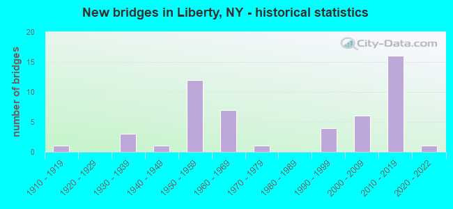
- New bridges - historical statistics
- 11910-1919
- 31930-1939
- 11940-1949
- 121950-1959
- 71960-1969
- 11970-1979
- 41990-1999
- 62000-2009
- 162010-2019
- 12020-2022

- Reconstructed bridges - Historical Statistics
- 21970-1979
- 41980-1989
- 11990-1999
- 52000-2009
- 12010-2019


- Bridge Condition - Deck
- 5.4%Excellent
- 16.2%Very good
- 27.0%Good
- 29.7%Satisfactory
- 21.6%Fair

- Bridge Condition - Superstructure
- 5.4%Excellent
- 35.1%Very good
- 35.1%Good
- 21.6%Satisfactory
- 2.7%Fair

- Bridge Condition - Substructure
- 2.7%Excellent
- 29.7%Very good
- 27.0%Good
- 29.7%Satisfactory
- 8.1%Fair
- 2.7%Poor

- Bridge Condition - Channel
- 3.4%Very good
- 44.8%Good
- 24.1%Satisfactory
- 24.1%Fair
- 3.4%Poor

- Bridge Condition - Culverts
- 33.3%Good
- 33.3%Fair
- 33.3%Poor
Find on map >> Show street view
Structure Number: 335682, Location: 1.4 MI SE WHITE SULFR SPR (Lat: 41.786953, Lng: -74.817467), Route carried "on" structure: Other road , Year Built: 2021, Status: Open, Structure Length: 2.16m (7.09ft), Average Daily Traffic: 113 (year 2018), Truck Traffic: 3%, Average Future Daily Traffic: 158 (year 2038), Design Load: HL 93, Features Intersected: SWAN LAKE INLET, Facility Carried by Structure: TOWNSEND ROAD
Minimum Vertical Clearance: 30+ m (98+ ft), Kilometerpoint: 0.611, Lanes on structure: 2, Owner: County Highway Agency, Approaching Roadway Width: 6.1m (20.0ft), Material/Design: Prestressed concrete, Design/Construction: Box Beam or Girders - Multiple, Number Of Spans In Main Unit: 1, Length of Maximum Span: 20.4m (66.9ft), Curb-To-Curb Width: 6.6m (21.7ft), Out-to-Out Width: 7.4m (24.3ft)
Condition: Deck: Excellent, Superstructure: Excellent, Substructure: Excellent, Channel: Good, Operating Rating: 85.3 metric tons, Method Used To Determine Operating Rating: Load Factor (LF), Inventory Rating: 50.8 metric tons, Method Used To Determine Inventory Rating: Load Factor (LF), Structural Evaluation: Superior to present desirable criteria, Deck Geometry: Meets minimum limits, Waterway Adequacy: Somewhat better than minimum adequacy, Approach Roadway Alignment: Equal to present minimum criteria, Length Of Structure Improvement: 1.98m (6.50ft), Designated Inspection Frequency: Every 24 months, Inspection Date: October 2021, Bridge Improvement Cost: $262,000, Roadway Improvement Cost: $153,000, Total Project Cost: $415,000 ( Estimate for 2021), Wearing Surface/Protective System: Wearing Surface: Bituminous, Membrane: Other
Find on map >> Show street view
Structure Number: 335683, Location: ACROSS SWAN LAKE (Lat: 41.760667, Lng: -74.792147), Route carried "on" structure: Other road , Year Built: 1955, Year Reconstructed: 2008, Status: Open, Structure Length: 0.98m (3.22ft), Average Daily Traffic: 122 (year 2018), Truck Traffic: 5%, Average Future Daily Traffic: 171 (year 2038), Features Intersected: SWAN LAKE, Facility Carried by Structure: KELLY BRIDGE ROAD
Minimum Vertical Clearance: 30+ m (98+ ft), Kilometerpoint: 0.290, Lanes on structure: 2, Owner: County Highway Agency, Approaching Roadway Width: 4.9m (16.1ft), Material/Design: Prestressed concrete, Design/Construction: Box Beam or Girders - Multiple, Number Of Spans In Main Unit: 1, Length of Maximum Span: 9.1m (29.9ft), Curb-To-Curb Width: 5.6m (18.4ft), Out-to-Out Width: 6.2m (20.3ft)
Condition: Deck: Excellent, Superstructure: Excellent, Substructure: Good, Channel: Good, Operating Rating: 66.5 metric tons, Method Used To Determine Operating Rating: Field evaluation and documented engineering judgment, Inventory Rating: 28.5 metric tons, Method Used To Determine Inventory Rating: Field evaluation and documented engineering judgment, Structural Evaluation: Better than present minimum criteria, Deck Geometry: High priority of corrective action, Waterway Adequacy: Somewhat better than minimum adequacy, Approach Roadway Alignment: Equal to present minimum criteria, Length Of Structure Improvement: 0.97m (3.18ft), Designated Inspection Frequency: Every 24 months, Inspection Date: September 2020, Bridge Improvement Cost: $277,000, Roadway Improvement Cost: $162,000, Total Project Cost: $439,000 ( Estimate for 2021), Wearing Surface/Protective System: Wearing Surface: Bituminous
Find on map >> Show street view
Structure Number: 335684, Location: IN PARKSVILLE (Lat: 41.857056, Lng: -74.760597), Route carried "on" structure: Other road , Year Built: 1912, Year Reconstructed: 1982, Status: Open, Structure Length: 1.16m (3.81ft), Average Daily Traffic: 279 (year 2018), Truck Traffic: 3%, Average Future Daily Traffic: 391 (year 2038), Features Intersected: LITTLE BEAVER KILL, Facility Carried by Structure: MAIN STREET
Minimum Vertical Clearance: 30+ m (98+ ft), Kilometerpoint: 0.869, Lanes on structure: 2, Owner: County Highway Agency, Approaching Roadway Width: 6.1m (20.0ft), Skew: 3 degrees, Material/Design: Wood or Timber, Design/Construction: Slab, Number Of Spans In Main Unit: 1, Length of Maximum Span: 11.2m (36.7ft), Curb-To-Curb Width: 9.8m (32.2ft), Out-to-Out Width: 10.1m (33.1ft)
Condition: Deck: Good, Superstructure: Good, Substructure: Satisfactory, Channel: Good, Operating Rating: 45.4 metric tons, Method Used To Determine Operating Rating: Load Factor (LF), Inventory Rating: 30.8 metric tons, Method Used To Determine Inventory Rating: Load Factor (LF), Structural Evaluation: Equal to present minimum criteria, Deck Geometry: Better than present minimum criteria, Waterway Adequacy: Equal to present minimum criteria, Approach Roadway Alignment: Equal to present desirable criteria, Length Of Structure Improvement: 1.15m (3.77ft), Designated Inspection Frequency: Every 24 months, Inspection Date: June 2020, Bridge Improvement Cost: $363,000, Roadway Improvement Cost: $213,000, Total Project Cost: $576,000 ( Estimate for 2021), Wearing Surface/Protective System: Wearing Surface: Bituminous
Find on map >> Show street view
Structure Number: 101357, Location: .9 MI N JCT SH 17 & SH 55 (Lat: 41.815203, Lng: -74.737781), Route carried "under" structure: State highway 17, Year Built: 2009, Structure Length: 0. m, Average Daily Traffic: 10,421 (year 1998), Features Intersected: 17 17 96091159, RTE 17, Facility Carried by Structure: WHITE BRIDGE INT
Minimum Vertical Clearance: 5.36m (17.59ft), Kilometerpoint: 26.243, Lanes on structure: 2, Lanes under structure: 2, Material/Design: Steel continuous, Design/Construction: Stringer/Multi-beam, Length of Maximum Span: 32.0m (105.0ft)
Find on map >> Show street view
Structure Number: 101358, Location: .5 MI N JCT SH 17 & SH 55 (Lat: 41.809678, Lng: -74.736403), Route carried "under" structure: State highway 17, Year Built: 2008, Structure Length: 0. m, Average Daily Traffic: 10,421 (year 1998), Features Intersected: 17 17 96091163, RTE 17, Facility Carried by Structure: COLD SPRINGS ROAD
Minimum Vertical Clearance: 7.01m (23.00ft), Kilometerpoint: 26.854, Lanes on structure: 2, Lanes under structure: 2, Material/Design: Steel continuous, Design/Construction: Stringer/Multi-beam, Length of Maximum Span: 32.0m (105.0ft)
Find on map >> Show street view
Structure Number: 1013619, Location: JCT SH 52 & SH 17 (Lat: 41.788297, Lng: -74.731314), Route carried "under" structure: State highway 17, Year Built: 1956, Structure Length: 0. m, Average Daily Traffic: 9,864 (year 1998), Features Intersected: 17 17 96091178, RTE 17,, Facility Carried by Structure: RTE 52
Minimum Vertical Clearance: 4.52m (14.83ft), Kilometerpoint: 28.688, Lanes on structure: 4, Lanes under structure: 2, Material/Design: Steel, Design/Construction: Stringer/Multi-beam, Length of Maximum Span: 27.4m (89.9ft)
Find on map >> Show street view
Structure Number: 1013659, Location: 09 MI S JCT RTS 17 + 52 (Lat: 41.774706, Lng: -74.733328), Route carried "under" structure: County highway , Year Built: 1960, Structure Length: 0. m, Average Daily Traffic: 5,140 (year 1981), Features Intersected: CR 175, Facility Carried by Structure: RTE 17
Minimum Vertical Clearance: 5.18m (16.99ft), Kilometerpoint: 0.000, Lanes on structure: 7, Lanes under structure: 2, Material/Design: Steel, Design/Construction: Stringer/Multi-beam, Length of Maximum Span: 17.6m (57.7ft)
Find on map >> Show street view
Structure Number: 101366, Location: 1.5 MI S EXIT 101 OF SH17 (Lat: 41.766700, Lng: -74.735703), Route carried "under" structure: State highway 17, Year Built: 1960, Structure Length: 0. m, Average Daily Traffic: 11,424 (year 1998), Features Intersected: 17 17 96091193 WB, RTE, Facility Carried by Structure: TWIN BRIDGE ROAD
Minimum Vertical Clearance: 5.23m (17.16ft), Kilometerpoint: 31.729, Lanes on structure: 2, Lanes under structure: 3, Material/Design: Steel, Design/Construction: Stringer/Multi-beam, Length of Maximum Span: 19.8m (65.0ft)
Find on map >> Show street view
Structure Number: 101367, Location: 31 MI S JCT RTS 17 + 52 (Lat: 41.743267, Lng: -74.733172), Route carried "under" structure: State highway 17, Year Built: 1960, Structure Length: 0. m, Average Daily Traffic: 11,424 (year 1998), Features Intersected: 17 17 96091210 WB, RTE, Facility Carried by Structure: QUEEN MOUNTAIN RD
Minimum Vertical Clearance: 5.36m (17.59ft), Kilometerpoint: 34.352, Lanes on structure: 2, Lanes under structure: 2, Material/Design: Steel, Design/Construction: Stringer/Multi-beam, Length of Maximum Span: 21.0m (68.9ft)
Find on map >> Show street view
Structure Number: 1079051, Location: 4 mi NW of Liberty (Lat: 41.854594, Lng: -74.761506), Route carried "under" structure: County highway , Year Built: 2011, Structure Length: 0. m, Features Intersected: COOLEY ROAD EXTEN, Facility Carried by Structure: RTE 17
Minimum Vertical Clearance: 7.62m (25.00ft), Kilometerpoint: 0.000, Lanes on structure: 2, Lanes under structure: 2, Material/Design: Steel, Design/Construction: Stringer/Multi-beam, Length of Maximum Span: 38.4m (126.0ft)
Find on map >> Show street view
Structure Number: 1079052, Location: Parksville (Lat: 41.854483, Lng: -74.761761), Route carried "under" structure: County highway , Year Built: 2011, Structure Length: 0. m, Features Intersected: Cooley Road Exten, Facility Carried by Structure: RTE 17
Minimum Vertical Clearance: 7.62m (25.00ft), Kilometerpoint: 0.000, Lanes on structure: 2, Lanes under structure: 2, Material/Design: Steel, Design/Construction: Stringer/Multi-beam, Length of Maximum Span: 38.4m (126.0ft)
Find on map >> Show street view
Structure Number: 1079061, Location: 4 mi NW of Liberty (Lat: 41.850236, Lng: -74.754731), Route carried "under" structure: County highway , Year Built: 2011, Structure Length: 0. m, Features Intersected: Parksville Road, Facility Carried by Structure: RTE 17
Minimum Vertical Clearance: 5.23m (17.16ft), Kilometerpoint: 0.000, Lanes on structure: 2, Lanes under structure: 2, Material/Design: Steel, Design/Construction: Stringer/Multi-beam, Length of Maximum Span: 26.5m (86.9ft)
Find on map >> Show street view
Structure Number: 1079062, Location: Parksville (Lat: 41.850008, Lng: -74.754617), Route carried "under" structure: County highway , Year Built: 2011, Structure Length: 0. m, Features Intersected: Parksville Road, Facility Carried by Structure: RTE 17
Minimum Vertical Clearance: 6.12m (20.08ft), Kilometerpoint: 0.000, Lanes on structure: 2, Lanes under structure: 2, Material/Design: Steel, Design/Construction: Stringer/Multi-beam, Length of Maximum Span: 26.5m (86.9ft)
Find on map >> Show street view
Structure Number: 1079361, Location: Jct Rts 17 & 55 (Lat: 41.802900, Lng: -74.735550), Route carried "under" structure: Bypass State highway , Year Built: 2013, Structure Length: 0. m, Features Intersected: 55 X, Facility Carried by Structure: RTE 17
Minimum Vertical Clearance: 5.71m (18.73ft), Kilometerpoint: 43.765, Lanes on structure: 2, Lanes under structure: 2, Material/Design: Steel, Design/Construction: Stringer/Multi-beam, Length of Maximum Span: 33.0m (108.3ft)
Find on map >> Show street view
Structure Number: 1079362, Location: jct Rts 17 & 55 (Lat: 41.802742, Lng: -74.735819), Route carried "under" structure: Bypass State highway , Year Built: 2013, Structure Length: 0. m, Features Intersected: 55 x, Facility Carried by Structure: RTE 17
Minimum Vertical Clearance: 4.67m (15.32ft), Kilometerpoint: 43.765, Lanes on structure: 2, Lanes under structure: 2, Material/Design: Steel, Design/Construction: Stringer/Multi-beam, Length of Maximum Span: 33.0m (108.3ft)