Bridge Statistics for Lincoln, Illinois (IL)
Condition, Traffic, Stress, Structural Evaluation, Project Costs
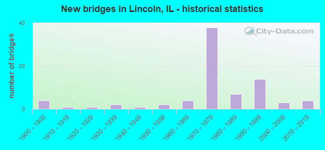
- New bridges - historical statistics
- 41900-1909
- 11910-1919
- 11920-1929
- 21930-1939
- 11940-1949
- 21950-1959
- 41960-1969
- 381970-1979
- 71980-1989
- 141990-1999
- 32000-2009
- 42010-2019

- Reconstructed bridges - Historical Statistics
- 11930-1939
- 01940-1949
- 01950-1959
- 11960-1969
- 01970-1979
- 01980-1989
- 01990-1999
- 82000-2009
- 12010-2019


- Bridge Condition - Deck
- 8.5%Very good
- 29.8%Good
- 53.2%Satisfactory
- 2.1%Fair
- 4.3%Poor
- 2.1%Failed

- Bridge Condition - Superstructure
- 29.2%Very good
- 16.7%Good
- 33.3%Satisfactory
- 12.5%Fair
- 6.3%Poor
- 2.1%Failed

- Bridge Condition - Substructure
- 18.8%Very good
- 33.3%Good
- 35.4%Satisfactory
- 6.3%Fair
- 4.2%Poor
- 2.1%Failed

- Bridge Condition - Channel
- 31.4%Very good
- 19.6%Good
- 23.5%Satisfactory
- 23.5%Fair
- 2.0%Failed

- Bridge Condition - Culverts
- 16.7%Very good
- 50.0%Good
- 33.3%Satisfactory
Find on map >> Show street view
Structure Number: 542035, Location: .7M N BL55 NW LINCLN (Lat: 40.164825, Lng: -89.386975), Route carried "on" structure: Other road , Year Built: 1998, Status: Open, Structure Length: 1.18m (3.87ft), Average Daily Traffic: 1,200 (year 2016), Truck Traffic: 11%, Average Future Daily Traffic: 1,857 (year 2032), Design Load: HS 20, Features Intersected: BRAINARDS BRANCH, Facility Carried by Structure: OLD IL 121
Minimum Vertical Clearance: 30+ m (98+ ft), Kilometerpoint: 0.064, Lanes on structure: 2, Owner: State Highway Agency, Approaching Roadway Width: 7.9m (25.9ft), Skew: 4 degrees, Material/Design: Concrete continuous, Design/Construction: Culvert, Number Of Spans In Main Unit: 2, Length of Maximum Span: 5.3m (17.4ft)
Condition: Channel: Very good, Culverts: Good, Operating Rating: 60.6 metric tons, Method Used To Determine Operating Rating: Load Factor (LF) rating reported by rating factor (RF) method using MS18 loading, Inventory Rating: 36.3 metric tons, Method Used To Determine Inventory Rating: Load Factor (LF) rating reported by rating factor (RF) method using MS18 loading, Structural Evaluation: Better than present minimum criteria, Waterway Adequacy: Superior to present desirable criteria, Approach Roadway Alignment: Equal to present desirable criteria, Designated Inspection Frequency: Every 48 months, Inspection Date: October 2020
Find on map >> Show street view
Structure Number: 542506, Location: 2 M N LINCOLN (Lat: 40.167206, Lng: -89.387011), Route carried "on" structure: County highway , Year Built: 2006, Status: Open, Structure Length: 0.70m (2.30ft), Average Daily Traffic: 2,000 (year 2016), Truck Traffic: 12%, Average Future Daily Traffic: 1,857 (year 2032), Design Load: HS 20, Features Intersected: TRIB BRAINARDS BR, Facility Carried by Structure: FAS 1774 OLD 121
Minimum Vertical Clearance: 30+ m (98+ ft), Kilometerpoint: 19.312, Lanes on structure: 2, Owner: State Highway Agency, Approaching Roadway Width: 9.8m (32.2ft), Material/Design: Concrete, Design/Construction: Culvert, Number Of Spans In Main Unit: 2, Length of Maximum Span: 3.0m (9.8ft)
Condition: Channel: Very good, Culverts: Good, Operating Rating: 63.2 metric tons, Method Used To Determine Operating Rating: Load Factor (LF) rating reported by rating factor (RF) method using MS18 loading, Inventory Rating: 37.9 metric tons, Method Used To Determine Inventory Rating: Load Factor (LF) rating reported by rating factor (RF) method using MS18 loading, Structural Evaluation: Better than present minimum criteria, Waterway Adequacy: Superior to present desirable criteria, Approach Roadway Alignment: Equal to present desirable criteria, Designated Inspection Frequency: Every 48 months, Inspection Date: Febuary 2021
Find on map >> Show street view
Structure Number: 543003, Location: 3 MI N LINCOLN (Lat: 40.192861, Lng: -89.361492), Route carried "on" structure: County highway , Year Built: 1970, Year Reconstructed: 2010, Status: Open, Structure Length: 15.21m (49.90ft), Average Daily Traffic: 400 (year 2016), Truck Traffic: 10%, Average Future Daily Traffic: 402 (year 2032), Design Load: HS 20, Features Intersected: KICKAPOO CK, Facility Carried by Structure: NICHOLSON RD
Minimum Vertical Clearance: 30+ m (98+ ft), Kilometerpoint: 10.975, Lanes on structure: 2, Owner: County Highway Agency, Approaching Roadway Width: 6.7m (22.0ft), Material/Design: Steel continuous, Design/Construction: Stringer/Multi-beam, Number Of Spans In Main Unit: 6, Length of Maximum Span: 30.2m (99.1ft), Curb-To-Curb Width: 9.3m (30.5ft), Out-to-Out Width: 10.4m (34.1ft)
Condition: Deck: Satisfactory, Superstructure: Fair, Substructure: Good, Channel: Fair, Operating Rating: 54.8 metric tons, Method Used To Determine Operating Rating: Load Factor (LF) rating reported by rating factor (RF) method using MS18 loading, Inventory Rating: 32.7 metric tons, Method Used To Determine Inventory Rating: Load Factor (LF) rating reported by rating factor (RF) method using MS18 loading, Structural Evaluation: Somewhat better than minimum adequacy, Deck Geometry: Equal to present minimum criteria, Waterway Adequacy: Equal to present desirable criteria, Approach Roadway Alignment: Equal to present desirable criteria, Designated Inspection Frequency: Every 24 months, Inspection Date: December 2021, Deck Structure Type: Concrete Cast-file-Place, Wearing Surface/Protective System: Wearing Surface: Other
Find on map >> Show street view
Structure Number: 543014, Location: 1 MI S LINCOLN (Lat: 40.125639, Lng: -89.358275), Route carried "on" structure: County highway , Year Built: 1928, Year Reconstructed: 1969, Status: Open, Structure Length: 1.89m (6.20ft), Average Daily Traffic: 950 (year 2016), Truck Traffic: 9%, Average Future Daily Traffic: 653 (year 2032), Design Load: HS 20, Features Intersected: Salt Springs, Facility Carried by Structure: PRIMM RD
Minimum Vertical Clearance: 30+ m (98+ ft), Kilometerpoint: 0.949, Lanes on structure: 2, Owner: County Highway Agency, Approaching Roadway Width: 7.3m (24.0ft), Material/Design: Prestressed concrete, Design/Construction: Box Beam or Girders - Multiple, Number Of Spans In Main Unit: 2, Length of Maximum Span: 9.1m (29.9ft), Curb-To-Curb Width: 8.2m (26.9ft), Out-to-Out Width: 9.5m (31.2ft)
Condition: Deck: Satisfactory, Superstructure: Satisfactory, Substructure: Fair, Channel: Fair, Operating Rating: 65.4 metric tons, Method Used To Determine Operating Rating: Load Factor (LF) rating reported by rating factor (RF) method using MS18 loading, Inventory Rating: 39.2 metric tons, Method Used To Determine Inventory Rating: Load Factor (LF) rating reported by rating factor (RF) method using MS18 loading, Structural Evaluation: Somewhat better than minimum adequacy, Deck Geometry: Somewhat better than minimum adequacy, Waterway Adequacy: Better than present minimum criteria, Approach Roadway Alignment: Equal to present desirable criteria, Designated Inspection Frequency: Every 24 months, Inspection Date: November 2019, Deck Structure Type: Concrete Precast Panels, Wearing Surface/Protective System: Wearing Surface: Bituminous
Find on map >> Show street view
Structure Number: 543051, Location: 3 MI W LINCOLN (Lat: 40.145292, Lng: -89.446222), Route carried "on" structure: County highway , Year Built: 1977, Status: Open, Structure Length: 11.03m (36.19ft), Average Daily Traffic: 775 (year 2016), Truck Traffic: 13%, Average Future Daily Traffic: 753 (year 2032), Design Load: HS 20, Features Intersected: KICKAPOO CK, Facility Carried by Structure: FAS 569
Minimum Vertical Clearance: 30+ m (98+ ft), Kilometerpoint: 11.442, Lanes on structure: 2, Owner: County Highway Agency, Approaching Roadway Width: 6.7m (22.0ft), Skew: 1 degrees, Material/Design: Prestressed concrete, Design/Construction: Box Beam or Girders - Multiple, Number Of Spans In Main Unit: 5, Length of Maximum Span: 21.9m (71.9ft), Curb-To-Curb Width: 9.3m (30.5ft), Out-to-Out Width: 9.3m (30.5ft)
Condition: Deck: Satisfactory, Superstructure: Satisfactory, Substructure: Fair, Channel: Fair, Operating Rating: 78.4 metric tons, Method Used To Determine Operating Rating: Load Factor (LF) rating reported by rating factor (RF) method using MS18 loading, Inventory Rating: 47.3 metric tons, Method Used To Determine Inventory Rating: Load Factor (LF) rating reported by rating factor (RF) method using MS18 loading, Structural Evaluation: Somewhat better than minimum adequacy, Deck Geometry: Equal to present minimum criteria, Waterway Adequacy: Equal to present desirable criteria, Approach Roadway Alignment: Equal to present desirable criteria, Designated Inspection Frequency: Every 24 months, Inspection Date: November 2019, Deck Structure Type: Concrete Precast Panels, Wearing Surface/Protective System: Wearing Surface: Bituminous, Membrane: Built-up
Find on map >> Show street view
Structure Number: 543064, Location: 1 MI S of Lincoln (Lat: 40.118367, Lng: -89.358231), Route carried "on" structure: County highway , Year Built: 2019, Status: Open, Structure Length: 5.61m (18.41ft), Average Daily Traffic: 950 (year 2016), Truck Traffic: 9%, Average Future Daily Traffic: 960 (year 2038), Design Load: HS 25 or greater, Features Intersected: Deer Creek, Facility Carried by Structure: FAS 561
Minimum Vertical Clearance: 30+ m (98+ ft), Kilometerpoint: 1.754, Lanes on structure: 2, Owner: County Highway Agency, Approaching Roadway Width: 9.1m (29.9ft), Material/Design: Steel continuous, Design/Construction: Stringer/Multi-beam, Number Of Spans In Main Unit: 3, Length of Maximum Span: 23.2m (76.1ft), Curb-To-Curb Width: 9.1m (29.9ft), Out-to-Out Width: 9.1m (29.9ft)
Condition: Deck: Good, Superstructure: Very good, Substructure: Very good, Channel: Very good, Operating Rating: 54.1 metric tons, Method Used To Determine Operating Rating: Load and Resistance Factor Rating (LRFR) rating reported by rating factor(RF) method using HL-93 loadings, Inventory Rating: 41.8 metric tons, Method Used To Determine Inventory Rating: Load and Resistance Factor Rating (LRFR) rating reported by rating factor(RF) method using HL-93 loadings, Structural Evaluation: Equal to present desirable criteria, Deck Geometry: Equal to present minimum criteria, Waterway Adequacy: Equal to present desirable criteria, Approach Roadway Alignment: Equal to present desirable criteria, Designated Inspection Frequency: Every 48 months, Inspection Date: December 2021, Deck Structure Type: Concrete Cast-file-Place, Wearing Surface/Protective System: Deck Protection: Epoxy Coated Reinforcing
Find on map >> Show street view
Structure Number: 543919, Location: 2 MI S LINCOLN (Lat: 40.109664, Lng: -89.358175), Route carried "on" structure: County highway , Year Built: 1997, Status: Open, Structure Length: 0.84m (2.76ft), Average Daily Traffic: 950 (year 2016), Truck Traffic: 9%, Average Future Daily Traffic: 653 (year 2032), Design Load: HS 20, Features Intersected: DEER CR TRIB, Facility Carried by Structure: PRIMM RD
Minimum Vertical Clearance: 30+ m (98+ ft), Kilometerpoint: 2.720, Lanes on structure: 2, Owner: County Highway Agency, Approaching Roadway Width: 7.3m (24.0ft), Material/Design: Concrete, Design/Construction: Frame, Number Of Spans In Main Unit: 1, Length of Maximum Span: 7.9m (25.9ft), Curb-To-Curb Width: 9.1m (29.9ft), Out-to-Out Width: 9.8m (32.2ft)
Condition: Superstructure: Very good, Substructure: Very good, Channel: Good, Operating Rating: 53.8 metric tons, Method Used To Determine Operating Rating: Field evaluation and documented engineering judgment, Inventory Rating: 32.4 metric tons, Method Used To Determine Inventory Rating: Field evaluation and documented engineering judgment, Structural Evaluation: Equal to present desirable criteria, Deck Geometry: Equal to present minimum criteria, Waterway Adequacy: Better than present minimum criteria, Approach Roadway Alignment: Equal to present desirable criteria, Designated Inspection Frequency: Every 48 months, Inspection Date: January 2018, Deck Structure Type: Other, Wearing Surface/Protective System: Wearing Surface: Bituminous, Membrane: Built-up
Find on map >> Show street view
Structure Number: 544251, Location: 3.5 MI N BROADWELL (Lat: 40.121611, Lng: -89.438489), Route carried "on" structure: County highway , Year Built: 1947, Status: Open, Structure Length: 0.80m (2.62ft), Average Daily Traffic: 200 (year 2016), Truck Traffic: 14%, Average Future Daily Traffic: 151 (year 2032), Features Intersected: LOCAL DRAINAGE, Facility Carried by Structure: ROCKY FORD RD
Minimum Vertical Clearance: 30+ m (98+ ft), Kilometerpoint: 0.386, Lanes on structure: 2, Owner: Town or Township Highway Agency, Approaching Roadway Width: 5.6m (18.4ft), Material/Design: Concrete continuous, Design/Construction: Culvert, Number Of Spans In Main Unit: 3, Length of Maximum Span: 2.6m (8.5ft)
Condition: Channel: Fair, Culverts: Satisfactory, Operating Rating: 24.3 metric tons, Method Used To Determine Operating Rating: Load Factor (LF) rating reported by rating factor (RF) method using MS18 loading, Inventory Rating: 14.6 metric tons, Method Used To Determine Inventory Rating: Load Factor (LF) rating reported by rating factor (RF) method using MS18 loading, Structural Evaluation: Meets minimum limits, Waterway Adequacy: Equal to present minimum criteria, Approach Roadway Alignment: Equal to present desirable criteria, Designated Inspection Frequency: Every 24 months, Inspection Date: December 2021
Find on map >> Show street view
Structure Number: 544252, Location: 2 MI SW LINCOLN (Lat: 40.121331, Lng: -89.406981), Route carried "on" structure: County highway , Year Built: 1955, Status: Open, Structure Length: 0.67m (2.20ft), Average Daily Traffic: 20 (year 2016), Truck Traffic: 20%, Average Future Daily Traffic: 59 (year 2032), Features Intersected: LOCAL DRAINAGE, Facility Carried by Structure: ROCKY FORD RD
Minimum Vertical Clearance: 30+ m (98+ ft), Kilometerpoint: 0.740, Lanes on structure: 2, Owner: Town or Township Highway Agency, Approaching Roadway Width: 4.9m (16.1ft), Material/Design: Concrete continuous, Design/Construction: Culvert, Number Of Spans In Main Unit: 2, Length of Maximum Span: 3.2m (10.5ft), Curb-To-Curb Width: 6.7m (22.0ft)
Condition: Channel: Fair, Culverts: Good, Operating Rating: 40.5 metric tons, Method Used To Determine Operating Rating: Field evaluation and documented engineering judgment, Inventory Rating: 24.3 metric tons, Method Used To Determine Inventory Rating: Field evaluation and documented engineering judgment, Structural Evaluation: Equal to present minimum criteria, Deck Geometry: Somewhat better than minimum adequacy, Waterway Adequacy: Better than present minimum criteria, Approach Roadway Alignment: Equal to present desirable criteria, Designated Inspection Frequency: Every 24 months, Inspection Date: December 2021
Find on map >> Show street view
Structure Number: 544302, Location: .25 MI E LINCOLN (Lat: 40.135642, Lng: -89.342492), Route carried "on" structure: County highway , Year Built: 1965, Status: Open, Structure Length: 2.04m (6.69ft), Average Daily Traffic: 200 (year 2016), Truck Traffic: 12%, Average Future Daily Traffic: 452 (year 2032), Design Load: HS 15, Features Intersected: DEER CK BR, Facility Carried by Structure: SOUTH BEASON RD
Minimum Vertical Clearance: 30+ m (98+ ft), Kilometerpoint: 0.499, Lanes on structure: 2, Owner: Town or Township Highway Agency, Approaching Roadway Width: 5.6m (18.4ft), Material/Design: Concrete, Design/Construction: Slab, Number Of Spans In Main Unit: 3, Length of Maximum Span: 7.6m (24.9ft), Curb-To-Curb Width: 7.3m (24.0ft), Out-to-Out Width: 8.0m (26.2ft)
Condition: Deck: Satisfactory, Superstructure: Satisfactory, Substructure: Poor, Channel: Fair, Operating Rating: 45.0 metric tons, Method Used To Determine Operating Rating: Load Factor (LF) rating reported by rating factor (RF) method using MS18 loading, Inventory Rating: 26.9 metric tons, Method Used To Determine Inventory Rating: Load Factor (LF) rating reported by rating factor (RF) method using MS18 loading, Structural Evaluation: Meets minimum limits, Deck Geometry: Somewhat better than minimum adequacy, Waterway Adequacy: Equal to present desirable criteria, Approach Roadway Alignment: Equal to present minimum criteria, Designated Inspection Frequency: Every 24 months, Inspection Date: November 2021, Deck Structure Type: Concrete Cast-file-Place, Wearing Surface/Protective System: Wearing Surface: Gravel
Find on map >> Show street view
Structure Number: 544305, Location: 3.5 MI E LINCOLN (Lat: 40.135344, Lng: -89.280664), Route carried "on" structure: County highway , Year Built: 1966, Status: Open, Structure Length: 4.66m (15.29ft), Average Daily Traffic: 200 (year 2016), Truck Traffic: 13%, Average Future Daily Traffic: 301 (year 2032), Design Load: HS 15, Features Intersected: DEER CK, Facility Carried by Structure: SOUTH BEASON RD
Minimum Vertical Clearance: 30+ m (98+ ft), Kilometerpoint: 5.761, Lanes on structure: 2, Owner: Town or Township Highway Agency, Approaching Roadway Width: 5.6m (18.4ft), Skew: 6 degrees, Material/Design: Steel, Design/Construction: Stringer/Multi-beam, Number Of Spans In Main Unit: 3, Length of Maximum Span: 16.5m (54.1ft), Curb-To-Curb Width: 7.3m (24.0ft), Out-to-Out Width: 8.0m (26.2ft)
Condition: Deck: Good, Superstructure: Good, Substructure: Good, Channel: Fair, Operating Rating: 33.4 metric tons, Method Used To Determine Operating Rating: Load Factor (LF) rating reported by rating factor (RF) method using MS18 loading, Inventory Rating: 20.1 metric tons, Method Used To Determine Inventory Rating: Load Factor (LF) rating reported by rating factor (RF) method using MS18 loading, Structural Evaluation: Somewhat better than minimum adequacy, Deck Geometry: Somewhat better than minimum adequacy, Waterway Adequacy: Equal to present minimum criteria, Approach Roadway Alignment: Equal to present minimum criteria, Designated Inspection Frequency: Every 24 months, Inspection Date: January 2020, Deck Structure Type: Concrete Cast-file-Place
Find on map >> Show street view
Structure Number: 544306, Location: 3 E .5 MI S LINCOLN (Lat: 40.130131, Lng: -89.291853), Route carried "on" structure: County highway , Year Built: 1970, Status: Open, Structure Length: 2.53m (8.30ft), Average Daily Traffic: 100 (year 2016), Truck Traffic: 16%, Average Future Daily Traffic: 126 (year 2032), Design Load: HS 15, Features Intersected: DEER CK, Facility Carried by Structure: JOHNSON SIPING RD
Minimum Vertical Clearance: 30+ m (98+ ft), Kilometerpoint: 0.579, Lanes on structure: 2, Owner: Town or Township Highway Agency, Approaching Roadway Width: 5.4m (17.7ft), Material/Design: Concrete, Design/Construction: Slab, Number Of Spans In Main Unit: 3, Length of Maximum Span: 24.7m (81.0ft), Curb-To-Curb Width: 7.3m (24.0ft), Out-to-Out Width: 8.0m (26.2ft)
Condition: Deck: Satisfactory, Superstructure: Satisfactory, Substructure: Fair, Channel: Fair, Operating Rating: 42.1 metric tons, Method Used To Determine Operating Rating: Load Factor (LF) rating reported by rating factor (RF) method using MS18 loading, Inventory Rating: 25.3 metric tons, Method Used To Determine Inventory Rating: Load Factor (LF) rating reported by rating factor (RF) method using MS18 loading, Structural Evaluation: Somewhat better than minimum adequacy, Deck Geometry: Equal to present minimum criteria, Waterway Adequacy: Equal to present minimum criteria, Approach Roadway Alignment: Equal to present minimum criteria, Designated Inspection Frequency: Every 24 months, Inspection Date: January 2020, Deck Structure Type: Concrete Cast-file-Place
Find on map >> Show street view
Structure Number: 54431, Location: 2 SE OF LINCOLN (Lat: 40.106600, Lng: -89.318111), Route carried "on" structure: County highway , Year Built: 1981, Status: Open, Structure Length: 1.22m (4.00ft), Average Daily Traffic: 125 (year 2016), Truck Traffic: 20%, Average Future Daily Traffic: 50 (year 2032), Design Load: HS 20, Features Intersected: DEER CREEK, Facility Carried by Structure: DOOLITTLE ROAD
Minimum Vertical Clearance: 30+ m (98+ ft), Kilometerpoint: 3.412, Lanes on structure: 2, Owner: Town or Township Highway Agency, Approaching Roadway Width: 4.9m (16.1ft), Skew: 2 degrees, Material/Design: Prestressed concrete, Design/Construction: Box Beam or Girders - Multiple, Number Of Spans In Main Unit: 1, Length of Maximum Span: 11.6m (38.1ft), Curb-To-Curb Width: 7.4m (24.3ft), Out-to-Out Width: 7.4m (24.3ft)
Condition: Deck: Good, Superstructure: Good, Substructure: Satisfactory, Channel: Satisfactory, Operating Rating: 44.4 metric tons, Method Used To Determine Operating Rating: Assigned rating based on Load Factor Design (LFD) reported by rating factor (RF) using MS18 loading, Inventory Rating: 32.4 metric tons, Method Used To Determine Inventory Rating: Assigned rating based on Load Factor Design (LFD) reported by rating factor (RF) using MS18 loading, Structural Evaluation: Equal to present minimum criteria, Deck Geometry: Somewhat better than minimum adequacy, Waterway Adequacy: Better than present minimum criteria, Approach Roadway Alignment: Equal to present desirable criteria, Designated Inspection Frequency: Every 24 months, Inspection Date: December 2021, Deck Structure Type: Concrete Precast Panels, Wearing Surface/Protective System: Wearing Surface: Gravel
Find on map >> Show street view
Structure Number: 544311, Location: 5 MI S LINCOLN (Lat: 40.072678, Lng: -89.371719), Route carried "on" structure: County highway , Year Built: 1991, Status: Open, Structure Length: 5.55m (18.21ft), Average Daily Traffic: 75 (year 2016), Truck Traffic: 29%, Average Future Daily Traffic: 75 (year 2032), Design Load: HS 20, Features Intersected: SALT CREEK, Facility Carried by Structure: TR 158
Minimum Vertical Clearance: 30+ m (98+ ft), Kilometerpoint: 3.331, Lanes on structure: 2, Owner: Town or Township Highway Agency, Approaching Roadway Width: 4.9m (16.1ft), Skew: 3 degrees, Material/Design: Prestressed concrete, Design/Construction: Box Beam or Girders - Multiple, Number Of Spans In Main Unit: 3, Length of Maximum Span: 23.9m (78.4ft), Curb-To-Curb Width: 7.3m (24.0ft), Out-to-Out Width: 7.3m (24.0ft)
Condition: Deck: Poor, Superstructure: Poor, Substructure: Satisfactory, Channel: Satisfactory, Operating Rating: 52.8 metric tons, Method Used To Determine Operating Rating: Load Factor (LF) rating reported by rating factor (RF) method using MS18 loading, Inventory Rating: 31.8 metric tons, Method Used To Determine Inventory Rating: Load Factor (LF) rating reported by rating factor (RF) method using MS18 loading, Structural Evaluation: Meets minimum limits, Deck Geometry: Equal to present minimum criteria, Waterway Adequacy: Equal to present minimum criteria, Approach Roadway Alignment: Equal to present desirable criteria, Designated Inspection Frequency: Every 24 months, Inspection Date: January 2020, Deck Structure Type: Concrete Precast Panels
Find on map >> Show street view
Structure Number: 544312, Location: 4 MI S of Lincoln (Lat: 40.077547, Lng: -89.371208), Route carried "on" structure: County highway , Year Built: 2008, Status: Open, Structure Length: 1.79m (5.87ft), Average Daily Traffic: 75 (year 2016), Truck Traffic: 29%, Average Future Daily Traffic: 25 (year 2032), Design Load: HS 20, Features Intersected: Trib to Salt Creek, Facility Carried by Structure: TR 158
Minimum Vertical Clearance: 30+ m (98+ ft), Kilometerpoint: 2.768, Lanes on structure: 2, Owner: Town or Township Highway Agency, Approaching Roadway Width: 5.8m (19.0ft), Material/Design: Prestressed concrete, Design/Construction: Box Beam or Girders - Multiple, Number Of Spans In Main Unit: 1, Length of Maximum Span: 17.0m (55.8ft), Curb-To-Curb Width: 8.6m (28.2ft), Out-to-Out Width: 8.6m (28.2ft)
Condition: Deck: Fair, Superstructure: Fair, Substructure: Good, Channel: Good, Operating Rating: 44.1 metric tons, Method Used To Determine Operating Rating: Assigned rating based on Load Factor Design (LFD) reported by rating factor (RF) using MS18 loading, Inventory Rating: 32.4 metric tons, Method Used To Determine Inventory Rating: Assigned rating based on Load Factor Design (LFD) reported by rating factor (RF) using MS18 loading, Structural Evaluation: Somewhat better than minimum adequacy, Deck Geometry: Better than present minimum criteria, Waterway Adequacy: Equal to present desirable criteria, Approach Roadway Alignment: Meets minimum limits, Designated Inspection Frequency: Every 24 months, Inspection Date: December 2020, Deck Structure Type: Concrete Precast Panels
Find on map >> Show street view
Structure Number: 54435, Location: 3 M E 1 M S LINCOLN (Lat: 40.119614, Lng: -89.291783), Route carried "on" structure: County highway , Year Built: 1974, Status: Open, Structure Length: 1.03m (3.38ft), Average Daily Traffic: 100 (year 2016), Truck Traffic: 16%, Average Future Daily Traffic: 126 (year 2032), Design Load: HS 15, Features Intersected: DEER CK TR 1B, Facility Carried by Structure: TR 234
Minimum Vertical Clearance: 30+ m (98+ ft), Kilometerpoint: 1.738, Lanes on structure: 2, Owner: Town or Township Highway Agency, Approaching Roadway Width: 4.7m (15.4ft), Skew: 4 degrees, Material/Design: Concrete continuous, Design/Construction: Culvert, Number Of Spans In Main Unit: 2, Length of Maximum Span: 5.1m (16.7ft)
Condition: Channel: Satisfactory, Culverts: Satisfactory, Operating Rating: 33.0 metric tons, Method Used To Determine Operating Rating: Load Factor (LF) rating reported by rating factor (RF) method using MS18 loading, Inventory Rating: 19.8 metric tons, Method Used To Determine Inventory Rating: Load Factor (LF) rating reported by rating factor (RF) method using MS18 loading, Structural Evaluation: Somewhat better than minimum adequacy, Waterway Adequacy: Better than present minimum criteria, Approach Roadway Alignment: Equal to present desirable criteria, Designated Inspection Frequency: Every 24 months, Inspection Date: January 2020
Find on map >> Show street view
Structure Number: 544352, Location: 2 MI S LINCOLN (Lat: 40.106642, Lng: -89.354175), Route carried "on" structure: County highway , Year Built: 1989, Status: Open, Structure Length: 0.76m (2.49ft), Average Daily Traffic: 225 (year 2016), Truck Traffic: 6%, Average Future Daily Traffic: 176 (year 2032), Design Load: HS 20, Features Intersected: DEER CREEK TRIBUTARY, Facility Carried by Structure: TR 143
Minimum Vertical Clearance: 30+ m (98+ ft), Kilometerpoint: 0.338, Lanes on structure: 2, Owner: Town or Township Highway Agency, Approaching Roadway Width: 5.1m (16.7ft), Material/Design: Concrete continuous, Design/Construction: Culvert, Number Of Spans In Main Unit: 2, Length of Maximum Span: 3.7m (12.1ft)
Condition: Channel: Good, Culverts: Very good, Operating Rating: 44.4 metric tons, Method Used To Determine Operating Rating: Assigned rating based on Load Factor Design (LFD) reported by rating factor (RF) using MS18 loading, Inventory Rating: 32.4 metric tons, Method Used To Determine Inventory Rating: Assigned rating based on Load Factor Design (LFD) reported by rating factor (RF) using MS18 loading, Structural Evaluation: Equal to present desirable criteria, Waterway Adequacy: Better than present minimum criteria, Approach Roadway Alignment: Equal to present desirable criteria, Designated Inspection Frequency: Every 48 months, Inspection Date: January 2018
Find on map >> Show street view
Structure Number: 5445, Location: 3 N .5 E LINCOLN (Lat: 40.208467, Lng: -89.354700), Route carried "on" structure: County highway , Year Built: 1900, Status: Posted for load, Structure Length: 0.79m (2.59ft), Average Daily Traffic: 50 (year 2016), Truck Traffic: 22%, Average Future Daily Traffic: 25 (year 2032), Features Intersected: KICKAPOO CREEK TRIB, Facility Carried by Structure: SKUNK HOLLOW RD
Minimum Vertical Clearance: 30+ m (98+ ft), Kilometerpoint: 0.756, Lanes on structure: 1, Owner: Town or Township Highway Agency, Approaching Roadway Width: 2.7m (8.9ft), Material/Design: Concrete, Design/Construction: Slab, Number Of Spans In Main Unit: 1, Length of Maximum Span: 7.6m (24.9ft), Curb-To-Curb Width: 4.5m (14.8ft), Out-to-Out Width: 5.4m (17.7ft)
Condition: Deck: Poor, Superstructure: Poor, Substructure: Satisfactory, Channel: Fair, Operating Rating: 9.1 metric tons, Method Used To Determine Operating Rating: Load Factor (LF) rating reported by rating factor (RF) method using MS18 loading, Inventory Rating: 5.5 metric tons, Method Used To Determine Inventory Rating: Load Factor (LF) rating reported by rating factor (RF) method using MS18 loading, Structural Evaluation: High priority of corrective action, Deck Geometry: Equal to present minimum criteria, Waterway Adequacy: Meets minimum limits, Approach Roadway Alignment: Equal to present minimum criteria, Bridge Posting: Required (Relationship of Operating Rating to Maximum Legal Load: > 39.9% below), Length Of Structure Improvement: 0.79m (2.59ft), Designated Inspection Frequency: Every 24 months, Inspection Date: December 2021, Bridge Improvement Cost: $20,000, Roadway Improvement Cost: $2,000, Total Project Cost: $30,000, Deck Structure Type: Concrete Cast-file-Place, Wearing Surface/Protective System: Wearing Surface: Gravel
Find on map >> Show street view
Structure Number: 544503, Location: 4 N 1 MI E LINCOLN (Lat: 40.210947, Lng: -89.346092), Route carried "on" structure: County highway , Year Built: 1904, Status: Closed, Structure Length: 4.88m (16.01ft), Average Daily Traffic: 50 (year 2016), Truck Traffic: 22%, Average Future Daily Traffic: 25 (year 2032), Features Intersected: KICKAPOO CK, Facility Carried by Structure: SKUNK HOLLOW RD
Minimum Vertical Clearance: 4.80m (15.75ft), Kilometerpoint: 1.577, Lanes on structure: 1, Owner: Town or Township Highway Agency, Approaching Roadway Width: 2.6m (8.5ft), Material/Design: Steel, Design/Construction: Truss - Thru, Number Of Spans In Main Unit: 1, Number Of Approach Spans: 2, Length of Maximum Span: 33.5m (109.9ft), Curb-To-Curb Width: 4.2m (13.8ft), Out-to-Out Width: 4.3m (14.1ft)
Condition: Deck: Failed, Superstructure: Failed, Substructure: Failed, Channel: Failed, Deck Geometry: Somewhat better than minimum adequacy, Bridge Posting: Required (Relationship of Operating Rating to Maximum Legal Load: > 39.9% below), Length Of Structure Improvement: 5.85m (19.19ft), Designated Inspection Frequency: Every 24 months, Critical Feature Inspection Frequency: Every 12 months, Inspection Date: December 2021, Critical Feature Inspection Date: December 2017, Bridge Improvement Cost: $199,000, Roadway Improvement Cost: $20,000, Total Project Cost: $299,000, Deck Structure Type: Wood or Timber, Wearing Surface/Protective System: Wearing Surface: Wood or Timber
Find on map >> Show street view
Structure Number: 544508, Location: 3 MI W LAWNDALE (Lat: 40.221833, Lng: -89.337006), Route carried "on" structure: County highway , Year Built: 1983, Status: Open, Structure Length: 7.68m (25.20ft), Average Daily Traffic: 50 (year 2016), Truck Traffic: 22%, Average Future Daily Traffic: 75 (year 2032), Design Load: HS 20+Mod, Features Intersected: KICKAPOO CREEK, Facility Carried by Structure: TR 61
Minimum Vertical Clearance: 30+ m (98+ ft), Kilometerpoint: 2.173, Lanes on structure: 2, Owner: Town or Township Highway Agency, Approaching Roadway Width: 4.9m (16.1ft), Skew: 3 degrees, Material/Design: Prestressed concrete, Design/Construction: Box Beam or Girders - Multiple, Number Of Spans In Main Unit: 5, Length of Maximum Span: 15.2m (49.9ft), Curb-To-Curb Width: 7.3m (24.0ft), Out-to-Out Width: 7.5m (24.6ft)
Condition: Deck: Satisfactory, Superstructure: Satisfactory, Substructure: Satisfactory, Channel: Fair, Operating Rating: 44.4 metric tons, Method Used To Determine Operating Rating: Assigned rating based on Load Factor Design (LFD) reported by rating factor (RF) using MS18 loading, Inventory Rating: 32.4 metric tons, Method Used To Determine Inventory Rating: Assigned rating based on Load Factor Design (LFD) reported by rating factor (RF) using MS18 loading, Structural Evaluation: Equal to present minimum criteria, Deck Geometry: Equal to present minimum criteria, Waterway Adequacy: Equal to present minimum criteria, Approach Roadway Alignment: Equal to present desirable criteria, Designated Inspection Frequency: Every 24 months, Inspection Date: December 2021, Deck Structure Type: Concrete Precast Panels, Wearing Surface/Protective System: Wearing Surface: Gravel
Find on map >> Show street view
Structure Number: 54455, Location: 1 MI S LAWNDALE (Lat: 40.200842, Lng: -89.282125), Route carried "on" structure: County highway , Year Built: 1955, Status: Open, Structure Length: 0.69m (2.26ft), Average Daily Traffic: 20 (year 2016), Truck Traffic: 10%, Average Future Daily Traffic: 25 (year 2032), Features Intersected: LOCAL DRAINAGE, Facility Carried by Structure: TR 81A
Minimum Vertical Clearance: 30+ m (98+ ft), Kilometerpoint: 1.513, Lanes on structure: 2, Owner: Town or Township Highway Agency, Approaching Roadway Width: 4.5m (14.8ft), Material/Design: Concrete continuous, Design/Construction: Culvert, Number Of Spans In Main Unit: 2, Length of Maximum Span: 3.4m (11.2ft)
Condition: Channel: Good, Culverts: Satisfactory, Operating Rating: 30.1 metric tons, Method Used To Determine Operating Rating: Load Factor (LF) rating reported by rating factor (RF) method using MS18 loading, Inventory Rating: 17.8 metric tons, Method Used To Determine Inventory Rating: Load Factor (LF) rating reported by rating factor (RF) method using MS18 loading, Structural Evaluation: Somewhat better than minimum adequacy, Waterway Adequacy: Meets minimum limits, Approach Roadway Alignment: Equal to present desirable criteria, Designated Inspection Frequency: Every 24 months, Inspection Date: December 2021
Find on map >> Show street view
Structure Number: 546, Location: 3 BLOCKS NIL10&UNION (Lat: 40.160683, Lng: -89.368033), Route carried "on" structure: Other road , Year Built: 1978, Status: Open, Structure Length: 0.79m (2.59ft), Average Daily Traffic: 2,050 (year 2016), Truck Traffic: 8%, Average Future Daily Traffic: 2,460 (year 2032), Design Load: HS 20, Features Intersected: BRAINARDS BRANCH, Facility Carried by Structure: UNION ST FAU 7719
Minimum Vertical Clearance: 30+ m (98+ ft), Kilometerpoint: 0.933, Lanes on structure: 2, Owner: City or Municipal Highway Agency, Approaching Roadway Width: 9.9m (32.5ft), Skew: 1 degrees, Material/Design: Concrete continuous, Design/Construction: Culvert, Number Of Spans In Main Unit: 2, Length of Maximum Span: 3.7m (12.1ft), Curb or Sidewalk Widths: Left: 1.5m (4.9ft), Right: 1.5m (4.9ft), Curb-To-Curb Width: 9.4m (30.8ft), Out-to-Out Width: 9.4m (30.8ft)
Condition: Channel: Satisfactory, Culverts: Good, Operating Rating: 44.4 metric tons, Method Used To Determine Operating Rating: Assigned rating based on Load Factor Design (LFD) reported by rating factor (RF) using MS18 loading, Inventory Rating: 32.4 metric tons, Method Used To Determine Inventory Rating: Assigned rating based on Load Factor Design (LFD) reported by rating factor (RF) using MS18 loading, Structural Evaluation: Better than present minimum criteria, Deck Geometry: Meets minimum limits, Waterway Adequacy: Equal to present desirable criteria, Approach Roadway Alignment: Equal to present desirable criteria, Designated Inspection Frequency: Every 48 months, Inspection Date: November 2021
Find on map >> Show street view
Structure Number: 546008, Location: 0.2 MI N IL RT 10 (Lat: 40.160708, Lng: -89.372089), Route carried "on" structure: City street , Year Built: 1966, Status: Open, Structure Length: 1.25m (4.10ft), Average Daily Traffic: 850 (year 2016), Truck Traffic: 6%, Average Future Daily Traffic: 954 (year 2032), Design Load: HS 15, Features Intersected: BRAINARDS BRANCH, Facility Carried by Structure: PALMER AVE
Minimum Vertical Clearance: 30+ m (98+ ft), Kilometerpoint: 0.483, Lanes on structure: 2, Owner: City or Municipal Highway Agency, Approaching Roadway Width: 7.9m (25.9ft), Skew: 1 degrees, Material/Design: Prestressed concrete, Design/Construction: Box Beam or Girders - Multiple, Number Of Spans In Main Unit: 1, Length of Maximum Span: 11.6m (38.1ft), Curb-To-Curb Width: 8.0m (26.2ft), Out-to-Out Width: 8.2m (26.9ft)
Condition: Deck: Satisfactory, Superstructure: Satisfactory, Substructure: Poor, Channel: Fair, Operating Rating: 43.4 metric tons, Method Used To Determine Operating Rating: Load Factor (LF) rating reported by rating factor (RF) method using MS18 loading, Inventory Rating: 25.9 metric tons, Method Used To Determine Inventory Rating: Load Factor (LF) rating reported by rating factor (RF) method using MS18 loading, Structural Evaluation: Meets minimum limits, Deck Geometry: Somewhat better than minimum adequacy, Waterway Adequacy: Equal to present desirable criteria, Approach Roadway Alignment: Equal to present desirable criteria, Designated Inspection Frequency: Every 24 months, Inspection Date: November 2021, Deck Structure Type: Concrete Precast Panels, Wearing Surface/Protective System: Wearing Surface: Gravel
Find on map >> Show street view
Structure Number: 546014, Location: AT FELDMAN DRIVE (Lat: 40.164133, Lng: -89.358333), Route carried "on" structure: Other road , Year Built: 1997, Status: Open, Structure Length: 0.81m (2.66ft), Average Daily Traffic: 1,500 (year 2016), Truck Traffic: 8%, Average Future Daily Traffic: 1,556 (year 2032), Design Load: HS 20, Features Intersected: BRAINARDS BRANCH, Facility Carried by Structure: NICHOLSON ROAD
Minimum Vertical Clearance: 30+ m (98+ ft), Kilometerpoint: 0.016, Lanes on structure: 2, Owner: City or Municipal Highway Agency, Approaching Roadway Width: 6.1m (20.0ft), Skew: 1 degrees, Material/Design: Concrete continuous, Design/Construction: Culvert, Number Of Spans In Main Unit: 2, Length of Maximum Span: 3.8m (12.5ft)
Condition: Channel: Satisfactory, Culverts: Good, Operating Rating: 44.1 metric tons, Method Used To Determine Operating Rating: Assigned rating based on Load Factor Design (LFD) reported by rating factor (RF) using MS18 loading, Inventory Rating: 32.4 metric tons, Method Used To Determine Inventory Rating: Assigned rating based on Load Factor Design (LFD) reported by rating factor (RF) using MS18 loading, Structural Evaluation: Better than present minimum criteria, Waterway Adequacy: Better than present minimum criteria, Approach Roadway Alignment: Equal to present desirable criteria, Designated Inspection Frequency: Every 48 months, Inspection Date: November 2021
Find on map >> Show street view
Structure Number: 546016, Location: 0.15 mi S Bus 55 (Lat: 40.162758, Lng: -89.377558), Route carried "on" structure: Other road , Year Built: 2016, Status: Open, Structure Length: 1.13m (3.71ft), Average Daily Traffic: 450 (year 2021), Truck Traffic: 2%, Average Future Daily Traffic: 650 (year 2036), Design Load: HS 25 or greater, Features Intersected: Brainards Branch, Facility Carried by Structure: FAU 7716(State St)
Minimum Vertical Clearance: 30+ m (98+ ft), Kilometerpoint: 0.241, Lanes on structure: 2, Owner: City or Municipal Highway Agency, Approaching Roadway Width: 7.3m (24.0ft), Skew: 2 degrees, Material/Design: Concrete continuous, Design/Construction: Culvert, Number Of Spans In Main Unit: 3, Length of Maximum Span: 3.7m (12.1ft), Curb-To-Curb Width: 11.6m (38.1ft), Out-to-Out Width: 12.2m (40.0ft)
Condition: Channel: Good, Culverts: Very good, Operating Rating: 54.1 metric tons, Method Used To Determine Operating Rating: Field evaluation and documented engineering judgment, Inventory Rating: 32.4 metric tons, Method Used To Determine Inventory Rating: Field evaluation and documented engineering judgment, Structural Evaluation: Equal to present desirable criteria, Deck Geometry: Better than present minimum criteria, Waterway Adequacy: Superior to present desirable criteria, Approach Roadway Alignment: Equal to present desirable criteria, Designated Inspection Frequency: Every 48 months, Inspection Date: December 2018
Find on map >> Show street view
Structure Number: 546018, Location: 0.46 mi N of IL 10 (Lat: 40.164425, Lng: -89.382242), Route carried "on" structure: City street , Year Built: 2019, Status: Open, Structure Length: 0.94m (3.08ft), Average Daily Traffic: 1,050 (year 2016), Truck Traffic: 7%, Average Future Daily Traffic: 1,061 (year 2038), Design Load: HS 25 or greater, Features Intersected: Brainards Branch, Facility Carried by Structure: Jefferson Street
Minimum Vertical Clearance: 30+ m (98+ ft), Kilometerpoint: 0.032, Lanes on structure: 2, Owner: City or Municipal Highway Agency, Approaching Roadway Width: 9.1m (29.9ft), Skew: 1 degrees, Material/Design: Concrete continuous, Design/Construction: Culvert, Number Of Spans In Main Unit: 3, Length of Maximum Span: 2.8m (9.2ft), Curb-To-Curb Width: 12.8m (42.0ft), Out-to-Out Width: 13.7m (44.9ft)
Condition: Channel: Satisfactory, Culverts: Good, Operating Rating: 54.1 metric tons, Method Used To Determine Operating Rating: Load and Resistance Factor Rating (LRFR) rating reported by rating factor(RF) method using HL-93 loadings, Inventory Rating: 41.8 metric tons, Method Used To Determine Inventory Rating: Load and Resistance Factor Rating (LRFR) rating reported by rating factor(RF) method using HL-93 loadings, Structural Evaluation: Better than present minimum criteria, Deck Geometry: Better than present minimum criteria, Waterway Adequacy: Superior to present desirable criteria, Approach Roadway Alignment: Equal to present desirable criteria, Designated Inspection Frequency: Every 48 months, Inspection Date: November 2021, Deck Structure Type: Concrete Cast-file-Place
Find on map >> Show street view
Structure Number: 54004, Location: BL 55 INT-SW LINCOLN (Lat: 40.112442, Lng: -89.416278), Route carried "under" structure: Interstate 55, Year Built: 1973, Structure Length: 0. m, Average Daily Traffic: 25,200 (year 2021), Truck Traffic: 34%, Features Intersected: I-55
Minimum Vertical Clearance: 5.05m (16.57ft), Kilometerpoint: 197.059, Lanes on structure: 2, Lanes under structure: 6, Material/Design: Steel continuous, Design/Construction: Stringer/Multi-beam, Length of Maximum Span: 34.4m (112.9ft)
Find on map >> Show street view
Structure Number: 540045, Location: .8 S IL10-1.6 W BL55 (Lat: 40.147000, Lng: -89.417111), Route carried "under" structure: Interstate 55, Year Built: 1973, Structure Length: 0. m, Average Daily Traffic: 25,200 (year 2021), Truck Traffic: 34%, Features Intersected: I-55, Facility Carried by Structure: CH E52
Minimum Vertical Clearance: 5.41m (17.75ft), Kilometerpoint: 200.889, Lanes on structure: 2, Lanes under structure: 6, Material/Design: Steel continuous, Design/Construction: Stringer/Multi-beam, Length of Maximum Span: 33.2m (108.9ft)
Find on map >> Show street view
Structure Number: 540046, Location: IL 10 INT- W LINCOLN (Lat: 40.159928, Lng: -89.417789), Route carried "under" structure: State highway 10, Year Built: 1974, Structure Length: 0. m, Average Daily Traffic: 3,700 (year 2021), Truck Traffic: 20%, Features Intersected: IL 10 & UP RR, Facility Carried by Structure: I-55 SB
Minimum Vertical Clearance: 6.20m (20.34ft), Kilometerpoint: 45.962, Lanes on structure: 3, Lanes under structure: 2, Material/Design: Steel continuous, Design/Construction: Stringer/Multi-beam, Length of Maximum Span: 27.8m (91.2ft)
Find on map >> Show street view
Structure Number: 540047, Location: IL 10 INT- W LINCOLN (Lat: 40.159664, Lng: -89.417281), Route carried "under" structure: State highway 10, Year Built: 1974, Structure Length: 0. m, Average Daily Traffic: 6,250 (year 2021), Truck Traffic: 20%, Features Intersected: IL 10 & UP RR, Facility Carried by Structure: I-55 NB
Minimum Vertical Clearance: 6.25m (20.51ft), Kilometerpoint: 46.010, Lanes on structure: 3, Lanes under structure: 2, Material/Design: Steel continuous, Design/Construction: Stringer/Multi-beam, Length of Maximum Span: 27.8m (91.2ft)
Find on map >> Show street view
Structure Number: 54005, Location: I-55/155 NW LINCOLN (Lat: 40.178664, Lng: -89.412164), Route carried "under" structure: Interstate 55, Year Built: 1973, Structure Length: 0. m, Average Daily Traffic: 21,900 (year 2021), Truck Traffic: 32%, Features Intersected: I-55 SB
Minimum Vertical Clearance: 5.03m (16.50ft), Kilometerpoint: 204.317, Lanes on structure: 2, Lanes under structure: 2, Material/Design: Steel, Design/Construction: Stringer/Multi-beam, Length of Maximum Span: 34.8m (114.2ft)
Find on map >> Show street view
Structure Number: 540051, Location: I-55/155 NW LINCOLN (Lat: 40.178403, Lng: -89.415972), Route carried "under" structure: Interstate 155, Year Built: 1973, Structure Length: 0. m, Average Daily Traffic: 9,650 (year 2021), Truck Traffic: 23%, Features Intersected: I-155 NB & I-55 SB
Minimum Vertical Clearance: 5.28m (17.32ft), Kilometerpoint: 0.692, Lanes on structure: 1, Lanes under structure: 4, Material/Design: Steel continuous, Design/Construction: Stringer/Multi-beam, Length of Maximum Span: 28.7m (94.2ft)
Find on map >> Show street view
Structure Number: 540052, Location: 2.7 N IL10-1 N BL 55 (Lat: 40.181331, Lng: -89.387231), Route carried "under" structure: Interstate 55, Year Built: 1973, Structure Length: 0. m, Average Daily Traffic: 21,900 (year 2021), Truck Traffic: 32%, Features Intersected: I-55, Facility Carried by Structure: OLD IL 121
Minimum Vertical Clearance: 5.00m (16.40ft), Kilometerpoint: 206.731, Lanes on structure: 2, Lanes under structure: 4, Material/Design: Steel continuous, Design/Construction: Stringer/Multi-beam, Length of Maximum Span: 32.9m (107.9ft)
Find on map >> Show street view
Structure Number: 540059, Location: 3.1 E I155/1 N BL 55 (Lat: 40.181531, Lng: -89.358561), Route carried "under" structure: Interstate 55, Year Built: 1973, Structure Length: 0. m, Average Daily Traffic: 21,900 (year 2021), Truck Traffic: 32%, Features Intersected: I-55, Facility Carried by Structure: CH S27
Minimum Vertical Clearance: 4.88m (16.01ft), Kilometerpoint: 209.161, Lanes on structure: 2, Lanes under structure: 4, Material/Design: Steel continuous, Design/Construction: Stringer/Multi-beam, Length of Maximum Span: 33.1m (108.6ft)
Find on map >> Show street view
Structure Number: 54006, Location: BUS55 INT NE LINCOLN (Lat: 40.185069, Lng: -89.319617), Route carried "under" structure: County highway , Year Built: 1974, Structure Length: 0. m, Average Daily Traffic: 3,250 (year 2019), Truck Traffic: 11%, Features Intersected: UP RR & BUS 55, Facility Carried by Structure: I-55 SB
Minimum Vertical Clearance: 7.59m (24.90ft), Kilometerpoint: 2.511, Lanes on structure: 2, Lanes under structure: 4, Material/Design: Steel continuous, Design/Construction: Stringer/Multi-beam, Length of Maximum Span: 55.9m (183.4ft)
Find on map >> Show street view
Structure Number: 540061, Location: BUS55 INT NE LINCOLN (Lat: 40.185389, Lng: -89.319258), Route carried "under" structure: County highway , Year Built: 1974, Structure Length: 0. m, Average Daily Traffic: 3,250 (year 2019), Truck Traffic: 11%, Features Intersected: UP RR & BUS 55, Facility Carried by Structure: I-55 NB
Minimum Vertical Clearance: 7.85m (25.75ft), Kilometerpoint: 2.527, Lanes on structure: 2, Lanes under structure: 4, Material/Design: Steel continuous, Design/Construction: Stringer/Multi-beam, Length of Maximum Span: 55.9m (183.4ft)
Find on map >> Show street view
Structure Number: 540071, Location: .6MI N I-155/I-55 (Lat: 40.187017, Lng: -89.418892), Route carried "under" structure: Interstate 155, Year Built: 1986, Structure Length: 0. m, Average Daily Traffic: 9,650 (year 2021), Truck Traffic: 23%, Features Intersected: FAI 155, Facility Carried by Structure: TR 87
Minimum Vertical Clearance: 5.11m (16.77ft), Kilometerpoint: 1.529, Lanes on structure: 2, Lanes under structure: 4, Material/Design: Prestressed concrete, Design/Construction: Stringer/Multi-beam, Length of Maximum Span: 32.6m (107.0ft)
Find on map >> Show street view
Structure Number: 540072, Location: 1.9MI N I-155/I-55 (Lat: 40.201639, Lng: -89.435031), Route carried "under" structure: Interstate 155, Year Built: 1986, Structure Length: 0. m, Average Daily Traffic: 9,650 (year 2021), Truck Traffic: 23%, Features Intersected: FAI 155, Facility Carried by Structure: TR 79
Minimum Vertical Clearance: 5.18m (16.99ft), Kilometerpoint: 3.685, Lanes on structure: 2, Lanes under structure: 4, Material/Design: Steel continuous, Design/Construction: Stringer/Multi-beam, Length of Maximum Span: 32.6m (107.0ft)
Find on map >> Show street view
Structure Number: 549901, Location: LINCOLN (Lat: 40.163789, Lng: -89.345292), Route carried "under" structure: Other road , Year Built: 1900, Structure Length: 0. m, Average Daily Traffic: 5,700 (year 2016), Truck Traffic: 11%, Features Intersected: FAU 7706, Facility Carried by Structure: IC&G RR
Minimum Vertical Clearance: 4.32m (14.17ft), Kilometerpoint: 7.387, Lanes under structure: 4, Material/Design: Steel, Design/Construction: Stringer/Multi-beam, Length of Maximum Span: 12.8m (42.0ft)
Find on map >> Show street view
Structure Number: 549904, Location: COLLEGE STREET (Lat: 40.143075, Lng: -89.374850), Route carried "under" structure: Other road , Year Built: 1911, Structure Length: 0. m, Average Daily Traffic: 600 (year 2016), Truck Traffic: 4%, Features Intersected: FAU 7716, Facility Carried by Structure: IC&G RR SPUR TRA
Minimum Vertical Clearance: 2.97m (9.74ft), Kilometerpoint: 2.607, Lanes under structure: 2, Material/Design: Prestressed concrete, Design/Construction: Box Beam or Girders - Multiple, Length of Maximum Span: 6.1m (20.0ft)
Find on map >> Show street view
Structure Number: 549905, Location: KICKAPOO &GERMAN (Lat: 40.139381, Lng: -89.373578), Route carried "under" structure: Other road , Year Built: 1909, Structure Length: 0. m, Average Daily Traffic: 1,250 (year 2016), Truck Traffic: 9%, Features Intersected: KICKAPOO STRFAU7717, Facility Carried by Structure: IC&G RR
Minimum Vertical Clearance: 3.28m (10.76ft), Kilometerpoint: 4.603, Lanes under structure: 2, Material/Design: Steel, Design/Construction: Girder and Floorbeam System, Length of Maximum Span: 11.0m (36.1ft)