Bridge Statistics for Lincolnton, North Carolina (NC)
Condition, Traffic, Stress, Structural Evaluation, Project Costs
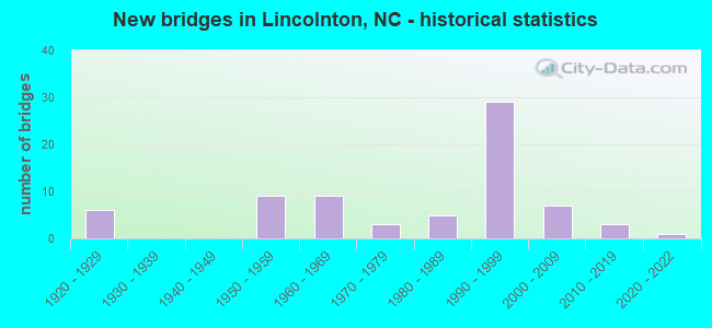
- New bridges - historical statistics
- 61920-1929
- 91950-1959
- 91960-1969
- 31970-1979
- 51980-1989
- 291990-1999
- 72000-2009
- 32010-2019
- 12020-2022

- Reconstructed bridges - Historical Statistics
- 11940-1949
- 41950-1959


- Bridge Condition - Deck
- 2.2%Excellent
- 6.5%Very good
- 41.3%Good
- 39.1%Satisfactory
- 10.9%Fair

- Bridge Condition - Superstructure
- 4.3%Excellent
- 23.9%Very good
- 37.0%Good
- 19.6%Satisfactory
- 10.9%Fair
- 2.2%Poor
- 2.2%Serious

- Bridge Condition - Substructure
- 2.2%Excellent
- 15.2%Very good
- 41.3%Good
- 23.9%Satisfactory
- 15.2%Fair
- 2.2%Poor

- Bridge Condition - Channel
- 5.4%Very good
- 48.6%Good
- 32.4%Satisfactory
- 13.5%Fair

- Bridge Condition - Culverts
- 45.5%Good
- 54.5%Satisfactory
Find on map >> Show street view
Structure Number: 1090242, Location: 0.2 MI. S. JCT. NC27 (Lat: 35.468200, Lng: -81.255456), Route carried "on" structure: State highway 1406, Year Built: 2002, Status: Open, Structure Length: 4.69m (15.39ft), Average Daily Traffic: 4,800 (year 2012), Truck Traffic: 7%, Average Future Daily Traffic: 9,600 (year 2040), Design Load: HS 20+Mod, Features Intersected: SCL RR
Minimum Vertical Clearance: 30+ m (98+ ft), Kilometerpoint: 0.000, Lanes on structure: 2, Owner: State Highway Agency, Approaching Roadway Width: 9.1m (29.9ft), Skew: 5 degrees, Material/Design: Steel continuous, Design/Construction: Stringer/Multi-beam, Number Of Spans In Main Unit: 2, Length of Maximum Span: 22.5m (73.8ft), Curb or Sidewalk Widths: Left: 1.2m (3.9ft), Right: 1.2m (3.9ft), Curb-To-Curb Width: 9.1m (29.9ft), Out-to-Out Width: 12.6m (41.3ft)
Condition: Deck: Very good, Superstructure: Very good, Substructure: Very good, Operating Rating: 89.8 metric tons, Method Used To Determine Operating Rating: Load Factor (LF), Inventory Rating: 76.2 metric tons, Method Used To Determine Inventory Rating: Load Factor (LF), Structural Evaluation: Equal to present desirable criteria, Deck Geometry: Meets minimum limits, Underclear: Better than present minimum criteria, Approach Roadway Alignment: Equal to present desirable criteria, Designated Inspection Frequency: Every 24 months, Inspection Date: April 2020, Deck Structure Type: Concrete Cast-file-Place, Wearing Surface/Protective System: Wearing Surface: Monolithic Concrete, Deck Protection: Epoxy Coated Reinforcing
Find on map >> Show street view
Structure Number: 1090244, Location: 0.8 MI. N. JCT. NC27 (Lat: 35.483458, Lng: -81.257189), Route carried "on" structure: State highway 1405, Year Built: 1922, Year Reconstructed: 1955, Status: Posted for load, Structure Length: 1.95m (6.40ft), Average Daily Traffic: 5,000 (year 2012), Truck Traffic: 7%, Average Future Daily Traffic: 10,000 (year 2025), Design Load: H 15, Features Intersected: WALKER BRANCH
Minimum Vertical Clearance: 30+ m (98+ ft), Kilometerpoint: 0.000, Lanes on structure: 2, Owner: State Highway Agency, Approaching Roadway Width: 6.0m (19.7ft), Skew: 3 degrees, Material/Design: Concrete, Design/Construction: Tee Beam, Number Of Spans In Main Unit: 2, Length of Maximum Span: 9.1m (29.9ft), Curb or Sidewalk Widths: Left: 0.4m (1.3ft), Right: 0.4m (1.3ft), Curb-To-Curb Width: 8.5m (27.9ft), Out-to-Out Width: 9.6m (31.5ft)
Condition: Deck: Good, Superstructure: Satisfactory, Substructure: Satisfactory, Channel: Fair, Operating Rating: 47.1 metric tons, Method Used To Determine Operating Rating: Load Factor (LF), Inventory Rating: 28.1 metric tons, Method Used To Determine Inventory Rating: Load Factor (LF), Structural Evaluation: Equal to present minimum criteria, Deck Geometry: Meets minimum limits, Waterway Adequacy: Better than present minimum criteria, Approach Roadway Alignment: Equal to present desirable criteria, Bridge Posting: Required (Relationship of Operating Rating to Maximum Legal Load: 0.1 - 9.9% below), Designated Inspection Frequency: Every 24 months, Inspection Date: Febuary 2022, Deck Structure Type: Concrete Cast-file-Place, Wearing Surface/Protective System: Wearing Surface: Bituminous
Find on map >> Show street view
Structure Number: 109025, Location: 0.3 MI.W.JCT.SR1002 (Lat: 35.538172, Lng: -81.415186), Route carried "on" structure: State highway 1113, Year Built: 1950, Status: Open, Structure Length: 0.73m (2.40ft), Average Daily Traffic: 950 (year 2019), Truck Traffic: 6%, Average Future Daily Traffic: 1,900 (year 2040), Design Load: HS 20+Mod, Features Intersected: INDIAN CREEK
Minimum Vertical Clearance: 30+ m (98+ ft), Kilometerpoint: 0.000, Lanes on structure: 2, Owner: State Highway Agency, Approaching Roadway Width: 6.0m (19.7ft), Skew: 3 degrees, Material/Design: Concrete continuous, Design/Construction: Culvert, Number Of Spans In Main Unit: 2, Length of Maximum Span: 3.0m (9.8ft)
Condition: Channel: Good, Culverts: Good, Operating Rating: 41.7 metric tons, Method Used To Determine Operating Rating: Field evaluation and documented engineering judgment, Inventory Rating: 32.6 metric tons, Method Used To Determine Inventory Rating: Field evaluation and documented engineering judgment, Structural Evaluation: Better than present minimum criteria, Waterway Adequacy: Better than present minimum criteria, Approach Roadway Alignment: Equal to present desirable criteria, Designated Inspection Frequency: Every 24 months, Inspection Date: January 2022
Find on map >> Show street view
Structure Number: 1090258, Location: 0.01 MI. W. JCT. SR1442 (Lat: 35.499531, Lng: -81.192536), Route carried "on" structure: State highway 1335, Year Built: 2004, Status: Open, Structure Length: 0.76m (2.49ft), Average Daily Traffic: 840 (year 2013), Truck Traffic: 7%, Average Future Daily Traffic: 1,680 (year 2025), Design Load: HS 20+Mod, Features Intersected: LICK RUN CREEK
Minimum Vertical Clearance: 30+ m (98+ ft), Kilometerpoint: 0.000, Lanes on structure: 2, Owner: State Highway Agency, Approaching Roadway Width: 6.0m (19.7ft), Skew: 3 degrees, Material/Design: Steel, Design/Construction: Culvert, Number Of Spans In Main Unit: 2, Length of Maximum Span: 2.7m (8.9ft)
Condition: Channel: Satisfactory, Culverts: Satisfactory, Operating Rating: 89.8 metric tons, Method Used To Determine Operating Rating: Load and Resistance Factor (LRFR), Inventory Rating: 87.9 metric tons, Method Used To Determine Inventory Rating: Load and Resistance Factor (LRFR), Structural Evaluation: Equal to present minimum criteria, Waterway Adequacy: Better than present minimum criteria, Approach Roadway Alignment: Equal to present desirable criteria, Designated Inspection Frequency: Every 24 months, Inspection Date: Febuary 2022
Find on map >> Show street view
Structure Number: 1090264, Location: 0.95 MI. N. JCT. SR1267 (Lat: 35.505156, Lng: -81.223986), Route carried "on" structure: State highway 1282, Year Built: 1990, Status: Open, Structure Length: 5.94m (19.49ft), Average Daily Traffic: 3,000 (year 2015), Truck Traffic: 7%, Average Future Daily Traffic: 6,000 (year 2040), Design Load: HS 20+Mod, Features Intersected: US321
Minimum Vertical Clearance: 30+ m (98+ ft), Kilometerpoint: 0.000, Lanes on structure: 2, Lanes under structure: 4, Owner: State Highway Agency, Approaching Roadway Width: 7.3m (24.0ft), Material/Design: Prestressed concrete, Design/Construction: Stringer/Multi-beam, Number Of Spans In Main Unit: 4, Length of Maximum Span: 18.5m (60.7ft), Curb-To-Curb Width: 9.1m (29.9ft), Out-to-Out Width: 10.0m (32.8ft)
Condition: Deck: Satisfactory, Superstructure: Very good, Substructure: Good, Operating Rating: 72.5 metric tons, Method Used To Determine Operating Rating: Load Factor (LF), Inventory Rating: 40.8 metric tons, Method Used To Determine Inventory Rating: Load Factor (LF), Structural Evaluation: Better than present minimum criteria, Deck Geometry: Meets minimum limits, Underclear: Equal to present minimum criteria, Approach Roadway Alignment: Equal to present desirable criteria, Designated Inspection Frequency: Every 24 months, Inspection Date: March 2020, Deck Structure Type: Concrete Cast-file-Place, Wearing Surface/Protective System: Wearing Surface: Integral Concrete, Deck Protection: Epoxy Coated Reinforcing
Find on map >> Show street view
Structure Number: 1090265, Location: 1.0 MI. S. JCT. NC155 (Lat: 35.513856, Lng: -81.223047), Route carried "on" structure: State highway 1338, Year Built: 1990, Status: Open, Structure Length: 6.03m (19.78ft), Average Daily Traffic: 940 (year 2016), Truck Traffic: 7%, Average Future Daily Traffic: 1,880 (year 2040), Design Load: HS 20+Mod, Features Intersected: US321
Minimum Vertical Clearance: 30+ m (98+ ft), Kilometerpoint: 0.000, Lanes on structure: 2, Lanes under structure: 4, Owner: State Highway Agency, Approaching Roadway Width: 6.4m (21.0ft), Material/Design: Prestressed concrete, Design/Construction: Stringer/Multi-beam, Number Of Spans In Main Unit: 4, Length of Maximum Span: 18.5m (60.7ft), Curb-To-Curb Width: 8.5m (27.9ft), Out-to-Out Width: 9.4m (30.8ft)
Condition: Deck: Satisfactory, Superstructure: Very good, Substructure: Good, Operating Rating: 72.5 metric tons, Method Used To Determine Operating Rating: Load Factor (LF), Inventory Rating: 41.7 metric tons, Method Used To Determine Inventory Rating: Load Factor (LF), Structural Evaluation: Better than present minimum criteria, Deck Geometry: Somewhat better than minimum adequacy, Underclear: Somewhat better than minimum adequacy, Approach Roadway Alignment: Equal to present desirable criteria, Designated Inspection Frequency: Every 24 months, Inspection Date: March 2020, Deck Structure Type: Concrete Cast-file-Place, Wearing Surface/Protective System: Wearing Surface: Integral Concrete, Deck Protection: Epoxy Coated Reinforcing
Find on map >> Show street view
Structure Number: 1090266, Location: 0.95 MI. S. JCT. SR1280 (Lat: 35.492281, Lng: -81.230117), Route carried "on" structure: State highway 1267, Year Built: 1991, Status: Open, Structure Length: 6.15m (20.18ft), Average Daily Traffic: 5,400 (year 2016), Truck Traffic: 7%, Average Future Daily Traffic: 10,800 (year 2040), Design Load: HS 20+Mod, Features Intersected: US321
Minimum Vertical Clearance: 30+ m (98+ ft), Kilometerpoint: 0.000, Lanes on structure: 2, Lanes under structure: 4, Owner: State Highway Agency, Approaching Roadway Width: 9.1m (29.9ft), Material/Design: Prestressed concrete, Design/Construction: Stringer/Multi-beam, Number Of Spans In Main Unit: 4, Length of Maximum Span: 18.5m (60.7ft), Curb-To-Curb Width: 9.1m (29.9ft), Out-to-Out Width: 10.0m (32.8ft)
Condition: Deck: Good, Superstructure: Very good, Substructure: Satisfactory, Operating Rating: 76.2 metric tons, Method Used To Determine Operating Rating: Load Factor (LF), Inventory Rating: 39.9 metric tons, Method Used To Determine Inventory Rating: Load Factor (LF), Structural Evaluation: Equal to present minimum criteria, Deck Geometry: Meets minimum limits, Underclear: Equal to present minimum criteria, Approach Roadway Alignment: Equal to present desirable criteria, Designated Inspection Frequency: Every 24 months, Inspection Date: March 2020, Deck Structure Type: Concrete Cast-file-Place, Wearing Surface/Protective System: Wearing Surface: Integral Concrete, Deck Protection: Epoxy Coated Reinforcing
Find on map >> Show street view
Structure Number: 1090267, Location: 0.2 MI. E. JCT. SR1279 (Lat: 35.528261, Lng: -81.222769), Route carried "on" structure: Business US 321, Year Built: 1991, Status: Open, Structure Length: 5.45m (17.88ft), Average Daily Traffic: 16,000 (year 2018), Truck Traffic: 6%, Average Future Daily Traffic: 32,000 (year 2040), Design Load: HS 20+Mod, Features Intersected: US321
Minimum Vertical Clearance: 30+ m (98+ ft), Kilometerpoint: 8.412, Lanes on structure: 2, Lanes under structure: 4, Owner: State Highway Agency, Approaching Roadway Width: 20.1m (65.9ft), Skew: 20 degrees, Material/Design: Prestressed concrete, Design/Construction: Stringer/Multi-beam, Number Of Spans In Main Unit: 4, Length of Maximum Span: 18.5m (60.7ft), Curb-To-Curb Width: 21.9m (71.9ft), Out-to-Out Width: 24.1m (79.1ft)
Condition: Deck: Satisfactory, Superstructure: Very good, Substructure: Very good, Operating Rating: 78.9 metric tons, Method Used To Determine Operating Rating: Load Factor (LF), Inventory Rating: 38.1 metric tons, Method Used To Determine Inventory Rating: Load Factor (LF), Structural Evaluation: Equal to present desirable criteria, Deck Geometry: Superior to present desirable criteria, Underclear: Meets minimum limits, Approach Roadway Alignment: Equal to present desirable criteria, Designated Inspection Frequency: Every 24 months, Inspection Date: March 2020, Deck Structure Type: Concrete Cast-file-Place, Wearing Surface/Protective System: Wearing Surface: Integral Concrete, Deck Protection: Epoxy Coated Reinforcing
Find on map >> Show street view
Structure Number: 1090268, Location: 0.3 MI. E. JCT. SR1262 (Lat: 35.470022, Lng: -81.222628), Route carried "on" structure: State highway 1294, Year Built: 1992, Status: Open, Structure Length: 6.00m (19.69ft), Average Daily Traffic: 5,300 (year 2013), Truck Traffic: 7%, Average Future Daily Traffic: 10,600 (year 2040), Design Load: HS 20+Mod, Features Intersected: US321
Minimum Vertical Clearance: 30+ m (98+ ft), Kilometerpoint: 0.000, Lanes on structure: 2, Lanes under structure: 4, Owner: State Highway Agency, Approaching Roadway Width: 9.1m (29.9ft), Skew: 2 degrees, Material/Design: Prestressed concrete, Design/Construction: Stringer/Multi-beam, Number Of Spans In Main Unit: 4, Length of Maximum Span: 20.4m (66.9ft), Curb-To-Curb Width: 9.1m (29.9ft), Out-to-Out Width: 10.1m (33.1ft)
Condition: Deck: Satisfactory, Superstructure: Very good, Substructure: Good, Operating Rating: 68.9 metric tons, Method Used To Determine Operating Rating: Load Factor (LF), Inventory Rating: 37.1 metric tons, Method Used To Determine Inventory Rating: Load Factor (LF), Structural Evaluation: Better than present minimum criteria, Deck Geometry: High priority of corrective action, Underclear: Meets minimum limits, Approach Roadway Alignment: Equal to present desirable criteria, Designated Inspection Frequency: Every 24 months, Inspection Date: March 2020, Deck Structure Type: Concrete Cast-file-Place, Wearing Surface/Protective System: Wearing Surface: Integral Concrete, Deck Protection: Epoxy Coated Reinforcing
Find on map >> Show street view
Structure Number: 109027, Location: 3.4 MI. S. JCT. SR1262 (Lat: 35.415694, Lng: -81.211081), Route carried "on" structure: Bypass US 321, Year Built: 1992, Status: Open, Structure Length: 4.23m (13.88ft), Average Daily Traffic: 17,250 (year 2018), Truck Traffic: 12%, Average Future Daily Traffic: 34,500 (year 2040), Design Load: HS 20+Mod, Features Intersected: US321 BUS, NC155
Minimum Vertical Clearance: 30+ m (98+ ft), Kilometerpoint: 0.000, Lanes on structure: 2, Lanes under structure: 3, Base Highway Network: Yes (Inventory Route: 2, Subroute: 21), Owner: State Highway Agency, Approaching Roadway Width: 11.2m (36.7ft), Skew: 10 degrees, Material/Design: Prestressed concrete, Design/Construction: Stringer/Multi-beam, Number Of Spans In Main Unit: 3, Length of Maximum Span: 23.7m (77.8ft), Curb-To-Curb Width: 11.5m (37.7ft), Out-to-Out Width: 12.5m (41.0ft)
Condition: Deck: Satisfactory, Superstructure: Very good, Substructure: Good, Operating Rating: 89.8 metric tons, Method Used To Determine Operating Rating: Load Factor (LF), Inventory Rating: 44.4 metric tons, Method Used To Determine Inventory Rating: Load Factor (LF), Structural Evaluation: Better than present minimum criteria, Deck Geometry: Somewhat better than minimum adequacy, Underclear: Equal to present minimum criteria, Approach Roadway Alignment: Equal to present desirable criteria, Designated Inspection Frequency: Every 24 months, Inspection Date: April 2020, Deck Structure Type: Concrete Cast-file-Place, Wearing Surface/Protective System: Wearing Surface: Integral Concrete, Deck Protection: Epoxy Coated Reinforcing
Find on map >> Show street view
Structure Number: 1090271, Location: 1.1 MI. S. JCT. NC27 (Lat: 35.462250, Lng: -81.219664), Route carried "on" structure: Bypass US 321, Year Built: 1992, Status: Open, Structure Length: 5.21m (17.09ft), Average Daily Traffic: 17,250 (year 2018), Truck Traffic: 12%, Average Future Daily Traffic: 34,500 (year 2040), Design Load: HS 20+Mod, Features Intersected: SR1262
Minimum Vertical Clearance: 30+ m (98+ ft), Kilometerpoint: 0.000, Lanes on structure: 2, Lanes under structure: 2, Base Highway Network: Yes (Inventory Route: 2, Subroute: 21), Owner: State Highway Agency, Approaching Roadway Width: 11.2m (36.7ft), Skew: 13 degrees, Material/Design: Prestressed concrete, Design/Construction: Stringer/Multi-beam, Number Of Spans In Main Unit: 3, Length of Maximum Span: 23.4m (76.8ft), Curb-To-Curb Width: 11.4m (37.4ft), Out-to-Out Width: 12.5m (41.0ft)
Condition: Deck: Satisfactory, Superstructure: Very good, Substructure: Very good, Operating Rating: 78.9 metric tons, Method Used To Determine Operating Rating: Load Factor (LF), Inventory Rating: 41.7 metric tons, Method Used To Determine Inventory Rating: Load Factor (LF), Structural Evaluation: Equal to present desirable criteria, Deck Geometry: Somewhat better than minimum adequacy, Underclear: Equal to present minimum criteria, Approach Roadway Alignment: Equal to present desirable criteria, Designated Inspection Frequency: Every 24 months, Inspection Date: April 2020, Deck Structure Type: Concrete Cast-file-Place, Wearing Surface/Protective System: Wearing Surface: Integral Concrete, Deck Protection: Epoxy Coated Reinforcing
Find on map >> Show street view
Structure Number: 1090272, Location: 1.1 MI. S. JCT. NC27 (Lat: 35.462356, Lng: -81.219947), Route carried "on" structure: Business US 321, Year Built: 1992, Status: Open, Structure Length: 5.66m (18.57ft), Average Daily Traffic: 17,250 (year 2018), Truck Traffic: 12%, Average Future Daily Traffic: 34,500 (year 2040), Design Load: HS 20+Mod, Features Intersected: SR1262
Minimum Vertical Clearance: 30+ m (98+ ft), Kilometerpoint: 0.000, Lanes on structure: 2, Lanes under structure: 2, Base Highway Network: Yes (Inventory Route: 2, Subroute: 21), Owner: State Highway Agency, Approaching Roadway Width: 11.5m (37.7ft), Skew: 13 degrees, Material/Design: Prestressed concrete, Design/Construction: Stringer/Multi-beam, Number Of Spans In Main Unit: 3, Length of Maximum Span: 23.4m (76.8ft), Curb-To-Curb Width: 11.5m (37.7ft), Out-to-Out Width: 12.5m (41.0ft)
Condition: Deck: Satisfactory, Superstructure: Very good, Substructure: Good, Operating Rating: 81.6 metric tons, Method Used To Determine Operating Rating: Load Factor (LF), Inventory Rating: 41.7 metric tons, Method Used To Determine Inventory Rating: Load Factor (LF), Structural Evaluation: Better than present minimum criteria, Deck Geometry: Somewhat better than minimum adequacy, Underclear: Superior to present desirable criteria, Approach Roadway Alignment: Equal to present desirable criteria, Designated Inspection Frequency: Every 24 months, Inspection Date: April 2020, Deck Structure Type: Concrete Cast-file-Place, Wearing Surface/Protective System: Wearing Surface: Integral Concrete, Deck Protection: Epoxy Coated Reinforcing
Find on map >> Show street view
Structure Number: 1090274, Location: 0.68 MI. N. JCT. NC155 (Lat: 35.537833, Lng: -81.226606), Route carried "on" structure: US 321, Year Built: 1993, Status: Open, Structure Length: 1.34m (4.40ft), Average Daily Traffic: 32,500 (year 2019), Truck Traffic: 14%, Average Future Daily Traffic: 65,000 (year 2040), Design Load: HS 20+Mod, Features Intersected: LARKARD CREEK
Minimum Vertical Clearance: 30+ m (98+ ft), Kilometerpoint: 0.000, Lanes on structure: 4, Base Highway Network: Yes (Inventory Route: 2, Subroute: 21), Owner: State Highway Agency, Approaching Roadway Width: 22.8m (74.8ft), Skew: 24 degrees, Material/Design: Concrete continuous, Design/Construction: Culvert, Number Of Spans In Main Unit: 3, Length of Maximum Span: 3.0m (9.8ft)
Condition: Channel: Satisfactory, Culverts: Satisfactory, Operating Rating: 89.8 metric tons, Method Used To Determine Operating Rating: Load and Resistance Factor (LRFR), Inventory Rating: 89.8 metric tons, Method Used To Determine Inventory Rating: Load and Resistance Factor (LRFR), Structural Evaluation: Equal to present minimum criteria, Waterway Adequacy: Better than present minimum criteria, Approach Roadway Alignment: Equal to present desirable criteria, Designated Inspection Frequency: Every 24 months, Inspection Date: January 2022
Find on map >> Show street view
Structure Number: 1090277, Location: 0.1 MI. E. JCT. SR1419 (Lat: 35.478017, Lng: -81.229503), Route carried "on" structure: State highway 27, Year Built: 1993, Status: Open, Structure Length: 7.83m (25.69ft), Average Daily Traffic: 28,000 (year 2016), Truck Traffic: 12%, Average Future Daily Traffic: 56,000 (year 2040), Design Load: HS 20+Mod, Features Intersected: US321
Minimum Vertical Clearance: 30+ m (98+ ft), Kilometerpoint: 0.000, Lanes on structure: 4, Lanes under structure: 6, Base Highway Network: Yes (Inventory Route: 3, Subroute: 27), Owner: State Highway Agency, Approaching Roadway Width: 23.1m (75.8ft), Skew: 1 degrees, Material/Design: Prestressed concrete, Design/Construction: Stringer/Multi-beam, Number Of Spans In Main Unit: 4, Length of Maximum Span: 21.3m (69.9ft), Curb-To-Curb Width: 30.5m (100.1ft), Out-to-Out Width: 31.3m (102.7ft)
Condition: Deck: Satisfactory, Superstructure: Very good, Substructure: Good, Operating Rating: 66.2 metric tons, Method Used To Determine Operating Rating: Load Factor (LF), Inventory Rating: 31.7 metric tons, Method Used To Determine Inventory Rating: Load Factor (LF), Structural Evaluation: Better than present minimum criteria, Deck Geometry: Superior to present desirable criteria, Underclear: Equal to present minimum criteria, Approach Roadway Alignment: Equal to present desirable criteria, Designated Inspection Frequency: Every 24 months, Inspection Date: March 2020, Deck Structure Type: Concrete Cast-file-Place, Wearing Surface/Protective System: Wearing Surface: Integral Concrete, Deck Protection: Epoxy Coated Reinforcing
Find on map >> Show street view
Structure Number: 1090278, Location: 0.1MI.S.JCT.NC27 (Lat: 35.471481, Lng: -81.251625), Route carried "on" structure: City street , Year Built: 1992, Status: Open, Structure Length: 3.68m (12.07ft), Average Daily Traffic: 1,200 (year 2013), Truck Traffic: 7%, Average Future Daily Traffic: 2,400 (year 2040), Features Intersected: CSX RAILROAD, Facility Carried by Structure: S.CEDAR ST.
Minimum Vertical Clearance: 30+ m (98+ ft), Kilometerpoint: 0.000, Lanes on structure: 2, Owner: City or Municipal Highway Agency, Approaching Roadway Width: 7.9m (25.9ft), Material/Design: Prestressed concrete, Design/Construction: Slab, Number Of Spans In Main Unit: 3, Length of Maximum Span: 13.4m (44.0ft), Curb or Sidewalk Widths: Left: 0.0m, Right: 1.2m (3.9ft), Curb-To-Curb Width: 7.9m (25.9ft), Out-to-Out Width: 10.0m (32.8ft)
Condition: Deck: Good, Superstructure: Good, Substructure: Good, Operating Rating: 51.7 metric tons, Method Used To Determine Operating Rating: Field evaluation and documented engineering judgment, Inventory Rating: 30.8 metric tons, Method Used To Determine Inventory Rating: Field evaluation and documented engineering judgment, Structural Evaluation: Better than present minimum criteria, Deck Geometry: Meets minimum limits, Underclear: Somewhat better than minimum adequacy, Approach Roadway Alignment: Equal to present desirable criteria, Designated Inspection Frequency: Every 24 months, Inspection Date: April 2020, Deck Structure Type: Concrete Precast Panels, Wearing Surface/Protective System: Wearing Surface: Bituminous
Find on map >> Show street view
Structure Number: 109003, Location: 0.07 MI. N. JCT. SR1250 (Lat: 35.453114, Lng: -81.243994), Route carried "under" structure: State highway 150, Year Built: 1955, Structure Length: 0. m, Average Daily Traffic: 12,000 (year 2015), Truck Traffic: 6%, Features Intersected: US321 BUS
Minimum Vertical Clearance: 4.64m (15.22ft), Kilometerpoint: 0.000, Lanes on structure: 2, Lanes under structure: 2, Material/Design: Steel, Design/Construction: Stringer/Multi-beam, Length of Maximum Span: 15.5m (50.9ft)
Find on map >> Show street view
Structure Number: 1090264, Location: 0.95 MI. N. JCT. SR1267 (Lat: 35.505156, Lng: -81.223986), Route carried "under" structure: US 321, Year Built: 1990, Structure Length: 0. m, Average Daily Traffic: 18,250 (year 2018), Truck Traffic: 12%, Features Intersected: SR1282
Minimum Vertical Clearance: 5.10m (16.73ft), Kilometerpoint: 0.000, Lanes on structure: 2, Lanes under structure: 2, Material/Design: Prestressed concrete, Design/Construction: Stringer/Multi-beam, Length of Maximum Span: 18.5m (60.7ft)
Find on map >> Show street view
Structure Number: 1090264, Location: 0.95 MI. N. JCT. SR1267 (Lat: 35.505156, Lng: -81.223986), Route carried "under" structure: US 321, Year Built: 1990, Structure Length: 0. m, Average Daily Traffic: 18,250 (year 2018), Truck Traffic: 12%, Features Intersected: SR1282
Minimum Vertical Clearance: 5.28m (17.32ft), Kilometerpoint: 0.000, Lanes on structure: 2, Lanes under structure: 2, Material/Design: Prestressed concrete, Design/Construction: Stringer/Multi-beam, Length of Maximum Span: 18.5m (60.7ft)
Find on map >> Show street view
Structure Number: 1090265, Location: 1.0 MI. S. JCT. NC155 (Lat: 35.513856, Lng: -81.223047), Route carried "under" structure: US 321, Year Built: 1990, Structure Length: 0. m, Average Daily Traffic: 14,000 (year 2013), Truck Traffic: 12%, Features Intersected: SR1338
Minimum Vertical Clearance: 5.28m (17.32ft), Kilometerpoint: 0.000, Lanes on structure: 2, Lanes under structure: 2, Material/Design: Prestressed concrete, Design/Construction: Stringer/Multi-beam, Length of Maximum Span: 18.5m (60.7ft)
Find on map >> Show street view
Structure Number: 1090265, Location: 1.0 MI. S. JCT. NC155 (Lat: 35.513856, Lng: -81.223047), Route carried "under" structure: US 321, Year Built: 1990, Structure Length: 0. m, Average Daily Traffic: 18,250 (year 2018), Truck Traffic: 12%, Features Intersected: SR1338
Minimum Vertical Clearance: 5.18m (16.99ft), Kilometerpoint: 0.000, Lanes on structure: 2, Lanes under structure: 2, Material/Design: Prestressed concrete, Design/Construction: Stringer/Multi-beam, Length of Maximum Span: 18.5m (60.7ft)
Find on map >> Show street view
Structure Number: 1090266, Location: 0.95 MI. S. JCT. SR1280 (Lat: 35.492281, Lng: -81.230117), Route carried "under" structure: US 321, Year Built: 1991, Structure Length: 0. m, Average Daily Traffic: 18,250 (year 2018), Truck Traffic: 12%, Features Intersected: SR1267
Minimum Vertical Clearance: 5.18m (16.99ft), Kilometerpoint: 0.000, Lanes on structure: 2, Lanes under structure: 2, Material/Design: Prestressed concrete, Design/Construction: Stringer/Multi-beam, Length of Maximum Span: 18.5m (60.7ft)
Find on map >> Show street view
Structure Number: 1090266, Location: 0.95 MI. S. JCT. SR1280 (Lat: 35.492281, Lng: -81.230117), Route carried "under" structure: US 321, Year Built: 1991, Structure Length: 0. m, Average Daily Traffic: 18,250 (year 2018), Truck Traffic: 12%, Features Intersected: SR1267
Minimum Vertical Clearance: 6.01m (19.72ft), Kilometerpoint: 0.000, Lanes on structure: 2, Lanes under structure: 2, Material/Design: Prestressed concrete, Design/Construction: Stringer/Multi-beam, Length of Maximum Span: 18.5m (60.7ft)
Find on map >> Show street view
Structure Number: 1090267, Location: 0.2 MI. E. JCT. SR1279 (Lat: 35.528261, Lng: -81.222769), Route carried "under" structure: US 321, Year Built: 1991, Structure Length: 0. m, Average Daily Traffic: 18,250 (year 2018), Truck Traffic: 12%, Features Intersected: US321 BUS
Minimum Vertical Clearance: 5.13m (16.83ft), Kilometerpoint: 8.534, Lanes on structure: 2, Lanes under structure: 2, Material/Design: Prestressed concrete, Design/Construction: Stringer/Multi-beam, Length of Maximum Span: 18.5m (60.7ft)
Find on map >> Show street view
Structure Number: 1090267, Location: 0.2 MI. E. JCT. SR1279 (Lat: 35.528261, Lng: -81.222769), Route carried "under" structure: US 321, Year Built: 1991, Structure Length: 0. m, Average Daily Traffic: 182,500 (year 2013), Truck Traffic: 12%, Features Intersected: US321 BUS
Minimum Vertical Clearance: 5.28m (17.32ft), Kilometerpoint: 8.534, Lanes on structure: 2, Lanes under structure: 2, Material/Design: Prestressed concrete, Design/Construction: Stringer/Multi-beam, Length of Maximum Span: 18.5m (60.7ft)
Find on map >> Show street view
Structure Number: 1090268, Location: 0.3 MI. E. JCT. SR1262 (Lat: 35.470022, Lng: -81.222628), Route carried "under" structure: US 321, Year Built: 1992, Structure Length: 0. m, Average Daily Traffic: 18,250 (year 2018), Truck Traffic: 12%, Features Intersected: SR1294
Minimum Vertical Clearance: 5.91m (19.39ft), Kilometerpoint: 0.000, Lanes on structure: 2, Lanes under structure: 2, Material/Design: Prestressed concrete, Design/Construction: Stringer/Multi-beam, Length of Maximum Span: 20.4m (66.9ft)
Find on map >> Show street view
Structure Number: 1090268, Location: 0.3 MI. E. JCT. SR1262 (Lat: 35.470022, Lng: -81.222628), Route carried "under" structure: US 321, Year Built: 1992, Structure Length: 0. m, Average Daily Traffic: 18,250 (year 2018), Truck Traffic: 12%, Features Intersected: SR1294
Minimum Vertical Clearance: 5.41m (17.75ft), Kilometerpoint: 0.000, Lanes on structure: 2, Lanes under structure: 2, Material/Design: Prestressed concrete, Design/Construction: Stringer/Multi-beam, Length of Maximum Span: 20.4m (66.9ft)
Find on map >> Show street view
Structure Number: 1090271, Location: 1.1 MI. S. JCT. NC27 (Lat: 35.462250, Lng: -81.219664), Route carried "under" structure: State highway 1262, Year Built: 1992, Structure Length: 0. m, Average Daily Traffic: 4,200 (year 2016), Truck Traffic: 7%, Features Intersected: US321 NBL
Minimum Vertical Clearance: 4.71m (15.45ft), Kilometerpoint: 0.000, Lanes on structure: 2, Lanes under structure: 2, Material/Design: Prestressed concrete, Design/Construction: Stringer/Multi-beam, Length of Maximum Span: 23.4m (76.8ft)
Find on map >> Show street view
Structure Number: 1090272, Location: 1.1 MI. S. JCT. NC27 (Lat: 35.462356, Lng: -81.219947), Route carried "under" structure: State highway 1262, Year Built: 1992, Structure Length: 0. m, Average Daily Traffic: 8,300 (year 2018), Truck Traffic: 7%, Features Intersected: US321 SBL
Minimum Vertical Clearance: 6.12m (20.08ft), Kilometerpoint: 0.000, Lanes on structure: 2, Lanes under structure: 2, Material/Design: Prestressed concrete, Design/Construction: Stringer/Multi-beam, Length of Maximum Span: 23.4m (76.8ft)
Find on map >> Show street view
Structure Number: 1090277, Location: 0.1 MI. E. JCT. SR1419 (Lat: 35.478017, Lng: -81.229503), Route carried "under" structure: US 321, Year Built: 1993, Structure Length: 0. m, Average Daily Traffic: 18,250 (year 2018), Truck Traffic: 12%, Features Intersected: NC27 & NC150
Minimum Vertical Clearance: 8.40m (27.56ft), Kilometerpoint: 0.000, Lanes on structure: 4, Lanes under structure: 3, Material/Design: Prestressed concrete, Design/Construction: Stringer/Multi-beam, Length of Maximum Span: 21.3m (69.9ft)
Find on map >> Show street view
Structure Number: 1090277, Location: 0.1 MI. E. JCT. SR1419 (Lat: 35.478017, Lng: -81.229503), Route carried "under" structure: US 321, Year Built: 1993, Structure Length: 0. m, Average Daily Traffic: 18,250 (year 2018), Truck Traffic: 12%, Features Intersected: NC27 & NC150
Minimum Vertical Clearance: 7.64m (25.07ft), Kilometerpoint: 0.000, Lanes on structure: 4, Lanes under structure: 3, Material/Design: Prestressed concrete, Design/Construction: Stringer/Multi-beam, Length of Maximum Span: 21.3m (69.9ft)