Bridge Statistics for Lincroft, New Jersey (NJ)
Condition, Traffic, Stress, Structural Evaluation, Project Costs
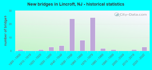
- New bridges - historical statistics
- 11900-1909
- 11920-1929
- 31930-1939
- 41940-1949
- 241950-1959
- 81960-1969
- 251970-1979
- 21980-1989
- 11990-1999
- 12010-2019
- 32020-2022
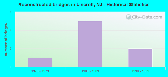
- Reconstructed bridges - Historical Statistics
- 11970-1979
- 51980-1989
- 21990-1999
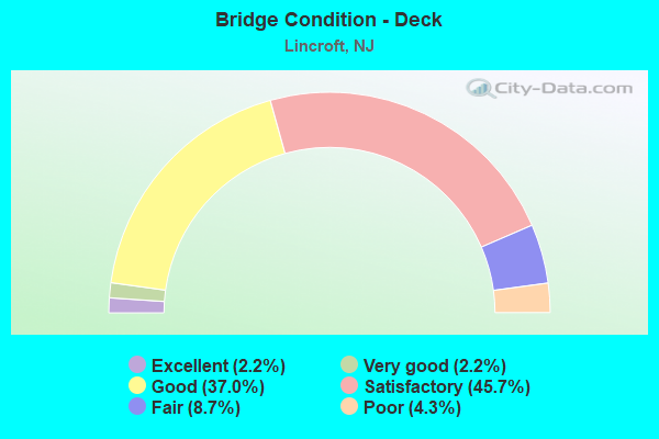
- Bridge Condition - Deck
- 2.2%Excellent
- 2.2%Very good
- 37.0%Good
- 45.7%Satisfactory
- 8.7%Fair
- 4.3%Poor
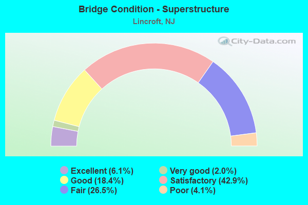
- Bridge Condition - Superstructure
- 6.1%Excellent
- 2.0%Very good
- 18.4%Good
- 42.9%Satisfactory
- 26.5%Fair
- 4.1%Poor
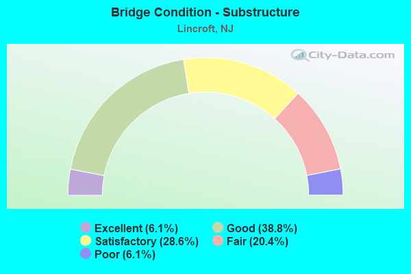
- Bridge Condition - Substructure
- 6.1%Excellent
- 38.8%Good
- 28.6%Satisfactory
- 20.4%Fair
- 6.1%Poor
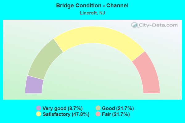
- Bridge Condition - Channel
- 8.7%Very good
- 21.7%Good
- 47.8%Satisfactory
- 21.7%Fair
Find on map >> Show street view
Structure Number: 361111O, Location: 0.7 MI SE GSP / RT 36 JCT (Lat: 40.346111, Lng: -74.113400), Route carried "on" structure: Other road GSP, Year Built: 1954, Status: Open, Structure Length: 4.08m (13.39ft), Average Daily Traffic: 45,506 (year 2020), Truck Traffic: 1%, Average Future Daily Traffic: 55,526 (year 2040), Design Load: H 20, Features Intersected: WEST FRONT STREET, Facility Carried by Structure: Parkway NBO
Minimum Vertical Clearance: 30+ m (98+ ft), Kilometerpoint: 178.862, Lanes on structure: 3, Lanes under structure: 2, Base Highway Network: Yes, Toll: On toll road, Owner: State Toll Authority, Approaching Roadway Width: 13.7m (44.9ft), Skew: 3 degrees, Material/Design: Steel, Design/Construction: Stringer/Multi-beam, Number Of Spans In Main Unit: 3, Length of Maximum Span: 13.1m (43.0ft), Curb-To-Curb Width: 14.3m (46.9ft), Out-to-Out Width: 15.4m (50.5ft)
Condition: Deck: Satisfactory, Superstructure: Fair, Substructure: Satisfactory, Operating Rating: 54.8 metric tons, Method Used To Determine Operating Rating: Load and Resistance Factor Rating (LRFR) rating reported by rating factor(RF) method using HL-93 loadings, Inventory Rating: 42.1 metric tons, Method Used To Determine Inventory Rating: Load and Resistance Factor Rating (LRFR) rating reported by rating factor(RF) method using HL-93 loadings, Structural Evaluation: Somewhat better than minimum adequacy, Deck Geometry: Meets minimum limits, Underclear: Meets minimum limits, Approach Roadway Alignment: Better than present minimum criteria, Designated Inspection Frequency: Every 24 months, Inspection Date: July 2020, Deck Structure Type: Concrete Cast-file-Place, Wearing Surface/Protective System: Wearing Surface: Bituminous
Find on map >> Show street view
Structure Number: 361111U, Location: 0.7 MI SE OF GSP&RT36 JCT (Lat: 40.345989, Lng: -74.114281), Route carried "on" structure: Other road GSP, Year Built: 1954, Status: Open, Structure Length: 3.96m (12.99ft), Average Daily Traffic: 53,383 (year 2020), Truck Traffic: 1%, Average Future Daily Traffic: 65,137 (year 2040), Design Load: H 20, Features Intersected: WEST FRONT STREET, Facility Carried by Structure: Parkway SBO
Minimum Vertical Clearance: 30+ m (98+ ft), Kilometerpoint: 178.862, Lanes on structure: 3, Lanes under structure: 2, Base Highway Network: Yes, Toll: On toll road, Owner: State Toll Authority, Approaching Roadway Width: 14.3m (46.9ft), Skew: 13 degrees, Material/Design: Steel, Design/Construction: Stringer/Multi-beam, Number Of Spans In Main Unit: 3, Length of Maximum Span: 12.8m (42.0ft), Curb-To-Curb Width: 14.3m (46.9ft), Out-to-Out Width: 15.4m (50.5ft)
Condition: Deck: Satisfactory, Superstructure: Fair, Substructure: Good, Operating Rating: 56.7 metric tons, Method Used To Determine Operating Rating: Load and Resistance Factor Rating (LRFR) rating reported by rating factor(RF) method using HL-93 loadings, Inventory Rating: 43.4 metric tons, Method Used To Determine Inventory Rating: Load and Resistance Factor Rating (LRFR) rating reported by rating factor(RF) method using HL-93 loadings, Structural Evaluation: Somewhat better than minimum adequacy, Deck Geometry: Meets minimum limits, Underclear: Meets minimum limits, Approach Roadway Alignment: Better than present minimum criteria, Designated Inspection Frequency: Every 24 months, Inspection Date: July 2020, Deck Structure Type: Concrete Cast-file-Place, Wearing Surface/Protective System: Wearing Surface: Bituminous
Find on map >> Show street view
Structure Number: 361121E, Location: 5096 mi. N of GSP/18N jct (Lat: 40.355711, Lng: -74.126119), Route carried "on" structure: Other road GSP, Year Built: 1972, Status: Open, Structure Length: 2.56m (8.40ft), Average Daily Traffic: 25,125 (year 2020), Truck Traffic: 1%, Average Future Daily Traffic: 30,060 (year 2040), Design Load: H 20, Features Intersected: MIDDLETOWN-LINCROFT RD
Minimum Vertical Clearance: 30+ m (98+ ft), Kilometerpoint: 180.472, Lanes on structure: 2, Lanes under structure: 2, Base Highway Network: Yes, Toll: On toll road, Owner: State Toll Authority, Approaching Roadway Width: 11.3m (37.1ft), Skew: 1 degrees, Material/Design: Prestressed concrete, Design/Construction: Box Beam or Girders - Multiple, Number Of Spans In Main Unit: 1, Length of Maximum Span: 24.4m (80.1ft), Curb-To-Curb Width: 11.7m (38.4ft), Out-to-Out Width: 12.6m (41.3ft)
Condition: Deck: Good, Superstructure: Good, Substructure: Good, Operating Rating: 36.6 metric tons, Method Used To Determine Operating Rating: Load and Resistance Factor Rating (LRFR) rating reported by rating factor(RF) method using HL-93 loadings, Inventory Rating: 27.9 metric tons, Method Used To Determine Inventory Rating: Load and Resistance Factor Rating (LRFR) rating reported by rating factor(RF) method using HL-93 loadings, Structural Evaluation: Better than present minimum criteria, Deck Geometry: Equal to present minimum criteria, Underclear: Meets minimum limits, Approach Roadway Alignment: Superior to present desirable criteria, Designated Inspection Frequency: Every 24 months, Inspection Date: August 2020, Deck Structure Type: Concrete Cast-file-Place, Wearing Surface/Protective System: Wearing Surface: Bituminous, Membrane: Preformed Fabric
Find on map >> Show street view
Structure Number: 361121I, Location: 5.96 mi. N. of GSP/18N Jc (Lat: 40.356217, Lng: -74.125931), Route carried "on" structure: Other road GSP, Year Built: 1972, Status: Open, Structure Length: 2.56m (8.40ft), Average Daily Traffic: 32,745 (year 2020), Truck Traffic: 1%, Average Future Daily Traffic: 39,955 (year 2040), Design Load: H 20, Features Intersected: MIDDLETOWN-LINCROFT RD
Minimum Vertical Clearance: 30+ m (98+ ft), Kilometerpoint: 180.472, Lanes on structure: 2, Lanes under structure: 2, Base Highway Network: Yes, Toll: On toll road, Owner: State Toll Authority, Approaching Roadway Width: 11.3m (37.1ft), Skew: 1 degrees, Material/Design: Prestressed concrete, Design/Construction: Box Beam or Girders - Multiple, Number Of Spans In Main Unit: 1, Length of Maximum Span: 24.4m (80.1ft), Curb-To-Curb Width: 11.7m (38.4ft), Out-to-Out Width: 12.6m (41.3ft)
Condition: Deck: Good, Superstructure: Good, Substructure: Good, Operating Rating: 36.6 metric tons, Method Used To Determine Operating Rating: Load and Resistance Factor Rating (LRFR) rating reported by rating factor(RF) method using HL-93 loadings, Inventory Rating: 27.9 metric tons, Method Used To Determine Inventory Rating: Load and Resistance Factor Rating (LRFR) rating reported by rating factor(RF) method using HL-93 loadings, Structural Evaluation: Better than present minimum criteria, Deck Geometry: Somewhat better than minimum adequacy, Underclear: High priority of corrective action, Approach Roadway Alignment: Superior to present desirable criteria, Designated Inspection Frequency: Every 24 months, Inspection Date: August 2020, Deck Structure Type: Concrete Cast-file-Place, Wearing Surface/Protective System: Wearing Surface: Bituminous, Membrane: Other
Find on map >> Show street view
Structure Number: 361121O, Location: 5.96 mi. N of GSP/18N Jct (Lat: 40.356417, Lng: -74.125981), Route carried "on" structure: Other road GSP, Year Built: 1954, Status: Open, Structure Length: 3.26m (10.70ft), Average Daily Traffic: 46,823 (year 2020), Truck Traffic: 1%, Average Future Daily Traffic: 57,132 (year 2040), Design Load: H 20, Features Intersected: MIDDLETOWN-LINCROFT ROAD
Minimum Vertical Clearance: 30+ m (98+ ft), Kilometerpoint: 180.472, Lanes on structure: 3, Lanes under structure: 2, Base Highway Network: Yes, Toll: On toll road, Owner: State Toll Authority, Approaching Roadway Width: 14.0m (45.9ft), Skew: 1 degrees, Material/Design: Steel, Design/Construction: Stringer/Multi-beam, Number Of Spans In Main Unit: 3, Length of Maximum Span: 11.0m (36.1ft), Curb-To-Curb Width: 14.3m (46.9ft), Out-to-Out Width: 15.2m (49.9ft)
Condition: Deck: Satisfactory, Superstructure: Fair, Substructure: Good, Operating Rating: 49.9 metric tons, Method Used To Determine Operating Rating: Load and Resistance Factor Rating (LRFR) rating reported by rating factor(RF) method using HL-93 loadings, Inventory Rating: 38.2 metric tons, Method Used To Determine Inventory Rating: Load and Resistance Factor Rating (LRFR) rating reported by rating factor(RF) method using HL-93 loadings, Structural Evaluation: Somewhat better than minimum adequacy, Deck Geometry: Meets minimum limits, Underclear: High priority of corrective action, Approach Roadway Alignment: Superior to present desirable criteria, Length Of Structure Improvement: 3.66m (12.01ft), Designated Inspection Frequency: Every 24 months, Inspection Date: August 2020, Bridge Improvement Cost: $100,000, Roadway Improvement Cost: $50,000, Total Project Cost: $500,000 ( Estimate for 2018), Deck Structure Type: Concrete Cast-file-Place, Wearing Surface/Protective System: Wearing Surface: Bituminous, Membrane: Preformed Fabric, Deck Protection: Epoxy Coated Reinforcing
Find on map >> Show street view
Structure Number: 361121U, Location: 5.96 mi. N. of GSP/18N Jc (Lat: 40.355531, Lng: -74.126189), Route carried "on" structure: Other road GSP, Year Built: 1954, Status: Open, Structure Length: 3.26m (10.70ft), Average Daily Traffic: 54,473 (year 2020), Truck Traffic: 1%, Average Future Daily Traffic: 66,468 (year 2040), Design Load: H 20, Features Intersected: MIDDLETOWN-LINCROFT RD
Minimum Vertical Clearance: 30+ m (98+ ft), Kilometerpoint: 180.472, Lanes on structure: 3, Lanes under structure: 2, Base Highway Network: Yes, Toll: On toll road, Owner: State Toll Authority, Approaching Roadway Width: 14.0m (45.9ft), Skew: 1 degrees, Material/Design: Steel, Design/Construction: Stringer/Multi-beam, Number Of Spans In Main Unit: 3, Length of Maximum Span: 11.0m (36.1ft), Curb-To-Curb Width: 14.3m (46.9ft), Out-to-Out Width: 15.2m (49.9ft)
Condition: Deck: Good, Superstructure: Satisfactory, Substructure: Satisfactory, Operating Rating: 54.1 metric tons, Method Used To Determine Operating Rating: Load and Resistance Factor Rating (LRFR) rating reported by rating factor(RF) method using HL-93 loadings, Inventory Rating: 41.8 metric tons, Method Used To Determine Inventory Rating: Load and Resistance Factor Rating (LRFR) rating reported by rating factor(RF) method using HL-93 loadings, Structural Evaluation: Equal to present minimum criteria, Deck Geometry: Meets minimum limits, Underclear: High priority of corrective action, Approach Roadway Alignment: Superior to present desirable criteria, Length Of Structure Improvement: 3.26m (10.70ft), Designated Inspection Frequency: Every 24 months, Inspection Date: August 2020, Bridge Improvement Cost: $100,000, Roadway Improvement Cost: $500,000, Total Project Cost: $500,000 ( Estimate for 2016), Deck Structure Type: Concrete Cast-file-Place, Wearing Surface/Protective System: Wearing Surface: Bituminous, Membrane: Preformed Fabric, Deck Protection: Other Coated Reinforcing
Find on map >> Show street view
Structure Number: 361139T, Location: 4.5 MI SE OF GSP&RT36 JCT (Lat: 40.374586, Lng: -74.146986), Route carried "on" structure: County highway 52, Year Built: 1954, Year Reconstructed: 1996, Status: Open, Structure Length: 13.69m (44.91ft), Average Daily Traffic: 30,277 (year 2020), Truck Traffic: 4%, Average Future Daily Traffic: 36,331 (year 2040), Design Load: H 20, Features Intersected: GSP
Minimum Vertical Clearance: 30+ m (98+ ft), Kilometerpoint: 4.136, Lanes on structure: 4, Lanes under structure: 10, Owner: State Toll Authority, Approaching Roadway Width: 15.2m (49.9ft), Material/Design: Steel continuous, Design/Construction: Stringer/Multi-beam, Number Of Spans In Main Unit: 8, Length of Maximum Span: 23.8m (78.1ft), Curb or Sidewalk Widths: Left: 1.8m (5.9ft), Right: 0.0m, Curb-To-Curb Width: 15.2m (49.9ft), Out-to-Out Width: 17.9m (58.7ft)
Condition: Deck: Satisfactory, Superstructure: Satisfactory, Substructure: Satisfactory, Operating Rating: 28.5 metric tons, Method Used To Determine Operating Rating: Load and Resistance Factor Rating (LRFR) rating reported by rating factor(RF) method using HL-93 loadings, Inventory Rating: 22.0 metric tons, Method Used To Determine Inventory Rating: Load and Resistance Factor Rating (LRFR) rating reported by rating factor(RF) method using HL-93 loadings, Structural Evaluation: Somewhat better than minimum adequacy, Deck Geometry: High priority of corrective action, Underclear: High priority of corrective action, Approach Roadway Alignment: Somewhat better than minimum adequacy, Length Of Structure Improvement: 14.02m (46.00ft), Designated Inspection Frequency: Every 24 months, Inspection Date: July 2020, Bridge Improvement Cost: $2,500,000, Roadway Improvement Cost: $350,000, Total Project Cost: $4,500,000 ( Estimate for 2016), Deck Structure Type: Concrete Cast-file-Place, Wearing Surface/Protective System: Wearing Surface: Latex Concrete, Deck Protection: Epoxy Coated Reinforcing
Find on map >> Show street view
Structure Number: 361144O, Location: 0.52 mi. N. of GSP/CR52 J (Lat: 40.379639, Lng: -74.154550), Route carried "on" structure: Other road GSP, Year Built: 1975, Status: Open, Structure Length: 3.11m (10.20ft), Average Daily Traffic: 61,740 (year 2020), Truck Traffic: 1%, Average Future Daily Traffic: 75,300 (year 2040), Design Load: H 20, Features Intersected: RAMP A (NBI EXIT TO NBO)
Minimum Vertical Clearance: 30+ m (98+ ft), Kilometerpoint: 184.109, Lanes on structure: 3, Lanes under structure: 1, Base Highway Network: Yes, Toll: On toll road, Owner: State Toll Authority, Approaching Roadway Width: 7.9m (25.9ft), Skew: 6 degrees, Material/Design: Concrete, Design/Construction: Frame, Number Of Spans In Main Unit: 1, Length of Maximum Span: 31.1m (102.0ft), Curb-To-Curb Width: 16.2m (53.1ft), Out-to-Out Width: 17.4m (57.1ft)
Condition: Superstructure: Satisfactory, Substructure: Satisfactory, Operating Rating: 82.3 metric tons, Method Used To Determine Operating Rating: Load and Resistance Factor Rating (LRFR) rating reported by rating factor(RF) method using HL-93 loadings, Inventory Rating: 63.5 metric tons, Method Used To Determine Inventory Rating: Load and Resistance Factor Rating (LRFR) rating reported by rating factor(RF) method using HL-93 loadings, Structural Evaluation: Equal to present minimum criteria, Deck Geometry: Equal to present minimum criteria, Underclear: Meets minimum limits, Approach Roadway Alignment: Equal to present desirable criteria, Designated Inspection Frequency: Every 24 months, Inspection Date: July 2020, Wearing Surface/Protective System: Wearing Surface: Bituminous, Membrane: Other
Find on map >> Show street view
Structure Number: 361152E, Location: 1.34 mi. N of GSP/CR52 Jc (Lat: 40.383892, Lng: -74.170453), Route carried "on" structure: Other road GSP, Year Built: 1975, Status: Open, Structure Length: 4.18m (13.71ft), Average Daily Traffic: 29,376 (year 2020), Truck Traffic: 1%, Average Future Daily Traffic: 35,820 (year 2040), Design Load: H 20, Features Intersected: S. HOLLAND ROAD
Minimum Vertical Clearance: 30+ m (98+ ft), Kilometerpoint: 185.429, Lanes on structure: 2, Lanes under structure: 2, Base Highway Network: Yes, Toll: On toll road, Owner: State Toll Authority, Approaching Roadway Width: 12.5m (41.0ft), Skew: 4 degrees, Material/Design: Prestressed concrete, Design/Construction: Stringer/Multi-beam, Number Of Spans In Main Unit: 3, Length of Maximum Span: 14.0m (45.9ft), Curb-To-Curb Width: 11.4m (37.4ft), Out-to-Out Width: 12.3m (40.4ft)
Condition: Deck: Good, Superstructure: Satisfactory, Substructure: Good, Operating Rating: 33.0 metric tons, Method Used To Determine Operating Rating: Load and Resistance Factor Rating (LRFR) rating reported by rating factor(RF) method using HL-93 loadings, Inventory Rating: 25.3 metric tons, Method Used To Determine Inventory Rating: Load and Resistance Factor Rating (LRFR) rating reported by rating factor(RF) method using HL-93 loadings, Structural Evaluation: Equal to present minimum criteria, Deck Geometry: Somewhat better than minimum adequacy, Underclear: High priority of corrective action, Approach Roadway Alignment: Equal to present desirable criteria, Designated Inspection Frequency: Every 24 months, Inspection Date: June 2020, Deck Structure Type: Concrete Cast-file-Place, Wearing Surface/Protective System: Wearing Surface: Bituminous, Membrane: Preformed Fabric
Find on map >> Show street view
Structure Number: 361152I, Location: 1.34 mi. N. of GSP/CR52 J (Lat: 40.384431, Lng: -74.169269), Route carried "on" structure: Other road GSP, Year Built: 1975, Status: Open, Structure Length: 4.02m (13.19ft), Average Daily Traffic: 34,782 (year 2020), Truck Traffic: 1%, Average Future Daily Traffic: 42,432 (year 2040), Design Load: H 20, Features Intersected: S. HOLLAND ROAD
Minimum Vertical Clearance: 30+ m (98+ ft), Kilometerpoint: 185.429, Lanes on structure: 2, Lanes under structure: 2, Base Highway Network: Yes, Toll: On toll road, Owner: State Toll Authority, Approaching Roadway Width: 11.6m (38.1ft), Skew: 3 degrees, Material/Design: Prestressed concrete, Design/Construction: Stringer/Multi-beam, Number Of Spans In Main Unit: 3, Length of Maximum Span: 13.4m (44.0ft), Curb-To-Curb Width: 11.4m (37.4ft), Out-to-Out Width: 12.3m (40.4ft)
Condition: Deck: Satisfactory, Superstructure: Satisfactory, Substructure: Good, Operating Rating: 33.0 metric tons, Method Used To Determine Operating Rating: Load and Resistance Factor Rating (LRFR) rating reported by rating factor(RF) method using HL-93 loadings, Inventory Rating: 20.7 metric tons, Method Used To Determine Inventory Rating: Load and Resistance Factor Rating (LRFR) rating reported by rating factor(RF) method using HL-93 loadings, Structural Evaluation: Somewhat better than minimum adequacy, Deck Geometry: Somewhat better than minimum adequacy, Underclear: High priority of corrective action, Approach Roadway Alignment: Equal to present desirable criteria, Length Of Structure Improvement: 4.03m (13.22ft), Designated Inspection Frequency: Every 24 months, Inspection Date: June 2020, Bridge Improvement Cost: $20,000, Roadway Improvement Cost: $50,000, Total Project Cost: $100,000 ( Estimate for 2018), Deck Structure Type: Concrete Cast-file-Place, Wearing Surface/Protective System: Wearing Surface: Bituminous, Membrane: Preformed Fabric
Find on map >> Show street view
Structure Number: 361152O, Location: 1.34 mi. N of GSP/CR52 Jc (Lat: 40.384636, Lng: -74.168864), Route carried "on" structure: Other road GSP, Year Built: 1945, Status: Open, Structure Length: 4.08m (13.39ft), Average Daily Traffic: 46,308 (year 2020), Truck Traffic: 1%, Average Future Daily Traffic: 56,508 (year 2040), Design Load: H 20, Features Intersected: S. HOLLAND ROAD, Facility Carried by Structure: Parkway NBO
Minimum Vertical Clearance: 30+ m (98+ ft), Kilometerpoint: 185.461, Lanes on structure: 3, Lanes under structure: 2, Base Highway Network: Yes, Toll: On toll road, Owner: State Toll Authority, Approaching Roadway Width: 14.0m (45.9ft), Skew: 4 degrees, Material/Design: Steel, Design/Construction: Stringer/Multi-beam, Number Of Spans In Main Unit: 3, Length of Maximum Span: 14.0m (45.9ft), Curb-To-Curb Width: 14.3m (46.9ft), Out-to-Out Width: 15.2m (49.9ft)
Condition: Deck: Satisfactory, Superstructure: Fair, Substructure: Satisfactory, Operating Rating: 60.9 metric tons, Method Used To Determine Operating Rating: Load and Resistance Factor Rating (LRFR) rating reported by rating factor(RF) method using HL-93 loadings, Inventory Rating: 47.0 metric tons, Method Used To Determine Inventory Rating: Load and Resistance Factor Rating (LRFR) rating reported by rating factor(RF) method using HL-93 loadings, Structural Evaluation: Somewhat better than minimum adequacy, Deck Geometry: Meets minimum limits, Underclear: High priority of corrective action, Approach Roadway Alignment: Equal to present desirable criteria, Designated Inspection Frequency: Every 24 months, Inspection Date: June 2020, Deck Structure Type: Concrete Cast-file-Place, Wearing Surface/Protective System: Wearing Surface: Bituminous
Find on map >> Show street view
Structure Number: 361152U, Location: 1.34 mi. N of GSP/CR52 Jc (Lat: 40.383739, Lng: -74.170728), Route carried "on" structure: Other road GSP, Year Built: 1954, Status: Open, Structure Length: 4.08m (13.39ft), Average Daily Traffic: 64,440 (year 2020), Truck Traffic: 1%, Average Future Daily Traffic: 78,600 (year 2040), Design Load: H 20, Features Intersected: S. HOLLAND ROAD, Facility Carried by Structure: Parkway SBO
Minimum Vertical Clearance: 30+ m (98+ ft), Kilometerpoint: 185.461, Lanes on structure: 3, Lanes under structure: 2, Base Highway Network: Yes, Toll: On toll road, Owner: State Toll Authority, Approaching Roadway Width: 14.0m (45.9ft), Skew: 4 degrees, Material/Design: Steel, Design/Construction: Stringer/Multi-beam, Number Of Spans In Main Unit: 3, Length of Maximum Span: 14.0m (45.9ft), Curb-To-Curb Width: 14.3m (46.9ft), Out-to-Out Width: 15.2m (49.9ft)
Condition: Deck: Satisfactory, Superstructure: Fair, Substructure: Satisfactory, Operating Rating: 59.3 metric tons, Method Used To Determine Operating Rating: Load and Resistance Factor Rating (LRFR) rating reported by rating factor(RF) method using HL-93 loadings, Inventory Rating: 45.7 metric tons, Method Used To Determine Inventory Rating: Load and Resistance Factor Rating (LRFR) rating reported by rating factor(RF) method using HL-93 loadings, Structural Evaluation: Somewhat better than minimum adequacy, Deck Geometry: Meets minimum limits, Underclear: High priority of corrective action, Approach Roadway Alignment: Equal to present desirable criteria, Designated Inspection Frequency: Every 24 months, Inspection Date: June 2020, Deck Structure Type: Concrete Cast-file-Place, Wearing Surface/Protective System: Wearing Surface: Bituminous, Membrane: Preformed Fabric
Find on map >> Show street view
Structure Number: 361101A, Location: 4 mi. N. of NJ 18 (Lat: 40.336831, Lng: -74.099511), Route carried "under" structure: County highway 520, Year Built: 2020, Structure Length: 0. m, Average Daily Traffic: 5,000 (year 2020), Truck Traffic: 1%, Features Intersected: NEWMAN SPRINGS RD(CR520), Facility Carried by Structure: PARKWAY RAMP 109NB
Minimum Vertical Clearance: 5.11m (16.77ft), Kilometerpoint: 23.883, Lanes on structure: 1, Lanes under structure: 5, Material/Design: Steel, Design/Construction: Girder and Floorbeam System, Length of Maximum Span: 43.0m (141.1ft)
Find on map >> Show street view
Structure Number: 361101E, Location: 3.96 mi. N. of GSP/18N Jc (Lat: 40.336800, Lng: -74.100581), Route carried "under" structure: County highway 520, Year Built: 1972, Structure Length: 0. m, Average Daily Traffic: 16,985 (year 2020), Truck Traffic: 1%, Features Intersected: NEWMAN SPRINGS RD(CR520), Facility Carried by Structure: Parking SBI
Minimum Vertical Clearance: 4.55m (14.93ft), Kilometerpoint: 23.883, Lanes on structure: 2, Lanes under structure: 6, Material/Design: Prestressed concrete, Design/Construction: Box Beam or Girders - Multiple, Length of Maximum Span: 21.0m (68.9ft)
Find on map >> Show street view
Structure Number: 361101I, Location: 3.96 mi. N. of GSP/18N Jc (Lat: 40.336850, Lng: -74.101667), Route carried "under" structure: County highway 520, Year Built: 1972, Structure Length: 0. m, Average Daily Traffic: 16,985 (year 2020), Truck Traffic: 1%, Features Intersected: NEWMAN SPRINGS RD(CR520), Facility Carried by Structure: GSP NBI
Minimum Vertical Clearance: 4.65m (15.26ft), Kilometerpoint: 23.963, Lanes on structure: 2, Lanes under structure: 5, Material/Design: Prestressed concrete, Design/Construction: Box Beam or Girders - Multiple, Length of Maximum Span: 21.6m (70.9ft)
Find on map >> Show street view
Structure Number: 361101O, Location: 3.96 mi. N. of GSP/18N Jc (Lat: 40.336850, Lng: -74.099978), Route carried "under" structure: County highway 520, Year Built: 1954, Structure Length: 0. m, Average Daily Traffic: 16,985 (year 2020), Truck Traffic: 1%, Features Intersected: NEWMAN SPRINGS RD(CR520), Facility Carried by Structure: GSP NBO
Minimum Vertical Clearance: 4.57m (14.99ft), Kilometerpoint: 23.963, Lanes on structure: 3, Lanes under structure: 5, Material/Design: Steel, Design/Construction: Stringer/Multi-beam, Length of Maximum Span: 21.9m (71.9ft)
Find on map >> Show street view
Structure Number: 361101U, Location: 3.96 mi. N. of GSP/18N Jc (Lat: 40.336711, Lng: -74.100789), Route carried "under" structure: County highway 520, Year Built: 1954, Structure Length: 0. m, Average Daily Traffic: 16,985 (year 2020), Truck Traffic: 1%, Features Intersected: NEWMAN SPRINGS RD(CR520), Facility Carried by Structure: GSP SBO
Minimum Vertical Clearance: 4.32m (14.17ft), Kilometerpoint: 23.883, Lanes on structure: 4, Lanes under structure: 5, Material/Design: Steel, Design/Construction: Stringer/Multi-beam, Length of Maximum Span: 20.7m (67.9ft)
Find on map >> Show street view
Structure Number: 361109E, Location: 4.83 mi. N. of GSP/18N Jc (Lat: 40.344431, Lng: -74.111350), Route carried "under" structure: City street , Year Built: 1972, Structure Length: 0. m, Average Daily Traffic: 7,682 (year 2020), Truck Traffic: 1%, Features Intersected: NORMANDY RD & NAD RR, Facility Carried by Structure: GSP SBI
Minimum Vertical Clearance: 6.55m (21.49ft), Kilometerpoint: 0.000, Lanes on structure: 2, Lanes under structure: 2, Material/Design: Prestressed concrete, Design/Construction: Box Beam or Girders - Multiple, Length of Maximum Span: 21.6m (70.9ft)
Find on map >> Show street view
Structure Number: 361109U, Location: 4.83 mi. N. of GSP/18N Jc (Lat: 40.344219, Lng: -74.111328), Route carried "under" structure: City street , Year Built: 1954, Structure Length: 0. m, Average Daily Traffic: 7,682 (year 2020), Truck Traffic: 1%, Features Intersected: NORMANDY RD & NAD RR, Facility Carried by Structure: GSP SBO
Minimum Vertical Clearance: 6.02m (19.75ft), Kilometerpoint: 0.000, Lanes on structure: 3, Lanes under structure: 2, Material/Design: Steel, Design/Construction: Stringer/Multi-beam, Length of Maximum Span: 22.3m (73.2ft)
Find on map >> Show street view
Structure Number: 361110I, Location: 4.83 mi. N of GSP/18N Jct (Lat: 40.344731, Lng: -74.111419), Route carried "under" structure: City street , Year Built: 1972, Structure Length: 0. m, Average Daily Traffic: 7,682 (year 2020), Truck Traffic: 1%, Features Intersected: NORMANDY RD & NAD RR, Facility Carried by Structure: GSP NBI
Minimum Vertical Clearance: 6.32m (20.73ft), Kilometerpoint: 0.000, Lanes on structure: 2, Lanes under structure: 2, Toll: On toll road, Material/Design: Prestressed concrete, Design/Construction: Box Beam or Girders - Multiple, Length of Maximum Span: 22.3m (73.2ft)
Find on map >> Show street view
Structure Number: 361110O, Location: 4.83 mi. N of GSP/18N Jct (Lat: 40.344961, Lng: -74.111469), Route carried "under" structure: City street , Year Built: 1954, Structure Length: 0. m, Average Daily Traffic: 7,682 (year 2020), Features Intersected: NORMANDY RD & NAD RR, Facility Carried by Structure: GSP NBO
Minimum Vertical Clearance: 6.12m (20.08ft), Kilometerpoint: 0.000, Lanes on structure: 3, Lanes under structure: 2, Material/Design: Steel, Design/Construction: Stringer/Multi-beam, Length of Maximum Span: 21.6m (70.9ft)
Find on map >> Show street view
Structure Number: 361111E, Location: 0.7MI SE OF GSP&RT36 JCT (Lat: 40.346031, Lng: -74.114019), Route carried "under" structure: City street , Year Built: 1975, Structure Length: 0. m, Average Daily Traffic: 9,790 (year 2020), Truck Traffic: 3%, Features Intersected: WEST FRONT STREET, Facility Carried by Structure: GSP SBI
Minimum Vertical Clearance: 4.90m (16.08ft), Kilometerpoint: 2.752, Lanes on structure: 2, Lanes under structure: 2, Material/Design: Prestressed concrete, Design/Construction: Box Beam or Girders - Multiple, Length of Maximum Span: 13.1m (43.0ft)
Find on map >> Show street view
Structure Number: 361111I, Location: 0.7MI SE GSP&RT 36 JCT (Lat: 40.346069, Lng: -74.113661), Route carried "under" structure: City street , Year Built: 1975, Structure Length: 0. m, Average Daily Traffic: 9,770 (year 2020), Truck Traffic: 3%, Features Intersected: WEST FRONT STREET, Facility Carried by Structure: GSP NBI
Minimum Vertical Clearance: 4.42m (14.50ft), Kilometerpoint: 2.832, Lanes on structure: 2, Lanes under structure: 2, Material/Design: Prestressed concrete, Design/Construction: Box Beam or Girders - Multiple, Length of Maximum Span: 13.1m (43.0ft)
Find on map >> Show street view
Structure Number: 361111O, Location: 0.7 MI SE GSP / RT 36 JCT (Lat: 40.346111, Lng: -74.113400), Route carried "under" structure: City street , Year Built: 1954, Structure Length: 0. m, Average Daily Traffic: 9,774 (year 2020), Truck Traffic: 3%, Features Intersected: WEST FRONT STREET, Facility Carried by Structure: Parkway NBO
Minimum Vertical Clearance: 4.42m (14.50ft), Kilometerpoint: 2.832, Lanes on structure: 3, Lanes under structure: 2, Material/Design: Steel, Design/Construction: Stringer/Multi-beam, Length of Maximum Span: 13.1m (43.0ft)
Find on map >> Show street view
Structure Number: 361111U, Location: 0.7 MI SE OF GSP&RT36 JCT (Lat: 40.345989, Lng: -74.114281), Route carried "under" structure: City street , Year Built: 1954, Structure Length: 0. m, Average Daily Traffic: 9,790 (year 2020), Truck Traffic: 3%, Features Intersected: WEST FRONT STREET, Facility Carried by Structure: Parkway SBO
Minimum Vertical Clearance: 4.50m (14.76ft), Kilometerpoint: 2.752, Lanes on structure: 3, Lanes under structure: 2, Material/Design: Steel, Design/Construction: Stringer/Multi-beam, Length of Maximum Span: 12.8m (42.0ft)
Find on map >> Show street view
Structure Number: 361121E, Location: 5096 mi. N of GSP/18N jct (Lat: 40.355711, Lng: -74.126119), Route carried "under" structure: County highway 50, Year Built: 1972, Structure Length: 0. m, Average Daily Traffic: 12,381 (year 2020), Truck Traffic: 4%, Features Intersected: MIDDLETOWN-LINCROFT RD, Facility Carried by Structure: GSP SBI
Minimum Vertical Clearance: 4.52m (14.83ft), Kilometerpoint: 5.971, Lanes on structure: 2, Lanes under structure: 2, Material/Design: Prestressed concrete, Design/Construction: Box Beam or Girders - Multiple, Length of Maximum Span: 24.4m (80.1ft)
Find on map >> Show street view
Structure Number: 361121I, Location: 5.96 mi. N. of GSP/18N Jc (Lat: 40.356217, Lng: -74.125931), Route carried "under" structure: County highway 50, Year Built: 1972, Structure Length: 0. m, Average Daily Traffic: 12,381 (year 2020), Truck Traffic: 4%, Features Intersected: MIDDLETOWN-LINCROFT RD, Facility Carried by Structure: GSP NBI
Minimum Vertical Clearance: 4.47m (14.67ft), Kilometerpoint: 6.051, Lanes on structure: 2, Lanes under structure: 2, Material/Design: Prestressed concrete, Design/Construction: Box Beam or Girders - Multiple, Length of Maximum Span: 24.4m (80.1ft)
Find on map >> Show street view
Structure Number: 361121O, Location: 5.96 mi. N of GSP/18N Jct (Lat: 40.356417, Lng: -74.125981), Route carried "under" structure: County highway 50, Year Built: 1954, Structure Length: 0. m, Average Daily Traffic: 12,381 (year 2020), Truck Traffic: 4%, Features Intersected: MIDDLETOWN-LINCROFT ROAD, Facility Carried by Structure: GSP NBO
Minimum Vertical Clearance: 4.24m (13.91ft), Kilometerpoint: 6.051, Lanes on structure: 3, Lanes under structure: 2, Toll: On toll road, Material/Design: Steel, Design/Construction: Stringer/Multi-beam, Length of Maximum Span: 11.0m (36.1ft)
Find on map >> Show street view
Structure Number: 361121U, Location: 5.96 mi. N. of GSP/18N Jc (Lat: 40.355531, Lng: -74.126189), Route carried "under" structure: County highway 50, Year Built: 1954, Structure Length: 0. m, Average Daily Traffic: 12,381 (year 2020), Truck Traffic: 4%, Features Intersected: MIDDLETOWN-LINCROFT RD, Facility Carried by Structure: GSP SBO
Minimum Vertical Clearance: 4.32m (14.17ft), Kilometerpoint: 5.971, Lanes on structure: 3, Lanes under structure: 2, Material/Design: Steel, Design/Construction: Stringer/Multi-beam, Length of Maximum Span: 11.0m (36.1ft)
Find on map >> Show street view
Structure Number: 361139T, Location: 4.5 MI SE OF GSP&RT36 JCT (Lat: 40.374586, Lng: -74.146986), Route carried "under" structure: Other road GSP, Year Built: 1954, Structure Length: 0. m, Average Daily Traffic: 107,141 (year 2020), Truck Traffic: 5%, Features Intersected: GSP, Facility Carried by Structure: Red Hill Rd(CR 52)
Minimum Vertical Clearance: 5.23m (17.16ft), Kilometerpoint: 183.240, Lanes on structure: 4, Lanes under structure: 10, Toll: On toll road, Material/Design: Steel continuous, Design/Construction: Stringer/Multi-beam, Length of Maximum Span: 23.8m (78.1ft)
Find on map >> Show street view
Structure Number: 361144O, Location: 0.52 mi. N. of GSP/CR52 J (Lat: 40.379639, Lng: -74.154550), Route carried "under" structure: Ramp Other road GSP, Year Built: 1975, Structure Length: 0. m, Average Daily Traffic: 314 (year 2020), Truck Traffic: 5%, Features Intersected: RAMP A (NBI EXIT TO NBO)
Minimum Vertical Clearance: 4.77m (15.65ft), Kilometerpoint: 184.109, Lanes on structure: 3, Lanes under structure: 1, Toll: On toll road, Material/Design: Concrete, Design/Construction: Frame, Length of Maximum Span: 31.1m (102.0ft)
Find on map >> Show street view
Structure Number: 361152E, Location: 1.34 mi. N of GSP/CR52 Jc (Lat: 40.383892, Lng: -74.170453), Route carried "under" structure: City street , Year Built: 1975, Structure Length: 0. m, Average Daily Traffic: 7,835 (year 2020), Truck Traffic: 3%, Features Intersected: S. HOLLAND ROAD, Facility Carried by Structure: GSP SBI
Minimum Vertical Clearance: 4.60m (15.09ft), Kilometerpoint: 0.000, Lanes on structure: 2, Lanes under structure: 2, Material/Design: Prestressed concrete, Design/Construction: Stringer/Multi-beam, Length of Maximum Span: 14.0m (45.9ft)
Find on map >> Show street view
Structure Number: 361152I, Location: 1.34 mi. N. of GSP/CR52 J (Lat: 40.384431, Lng: -74.169269), Route carried "under" structure: City street , Year Built: 1975, Structure Length: 0. m, Average Daily Traffic: 7,325 (year 2020), Truck Traffic: 3%, Features Intersected: S. HOLLAND ROAD, Facility Carried by Structure: GSP NBI
Minimum Vertical Clearance: 4.47m (14.67ft), Kilometerpoint: 0.000, Lanes on structure: 2, Lanes under structure: 2, Material/Design: Prestressed concrete, Design/Construction: Stringer/Multi-beam, Length of Maximum Span: 13.4m (44.0ft)
Find on map >> Show street view
Structure Number: 361152O, Location: 1.34 mi. N of GSP/CR52 Jc (Lat: 40.384636, Lng: -74.168864), Route carried "under" structure: City street , Year Built: 1945, Structure Length: 0. m, Average Daily Traffic: 6,529 (year 2020), Truck Traffic: 3%, Features Intersected: S. HOLLAND ROAD, Facility Carried by Structure: Parkway NBO
Minimum Vertical Clearance: 4.47m (14.67ft), Kilometerpoint: 0.000, Lanes on structure: 3, Lanes under structure: 2, Material/Design: Steel, Design/Construction: Stringer/Multi-beam, Length of Maximum Span: 14.0m (45.9ft)
Find on map >> Show street view
Structure Number: 361152U, Location: 1.34 mi. N of GSP/CR52 Jc (Lat: 40.383739, Lng: -74.170728), Route carried "under" structure: City street , Year Built: 1954, Structure Length: 0. m, Average Daily Traffic: 7,835 (year 2020), Truck Traffic: 3%, Features Intersected: S. HOLLAND ROAD, Facility Carried by Structure: Parkway SBO
Minimum Vertical Clearance: 4.55m (14.93ft), Kilometerpoint: 0.000, Lanes on structure: 3, Lanes under structure: 2, Material/Design: Steel, Design/Construction: Stringer/Multi-beam, Length of Maximum Span: 14.0m (45.9ft)