Bridge Statistics for Livonia, Michigan (MI)
Condition, Traffic, Stress, Structural Evaluation, Project Costs
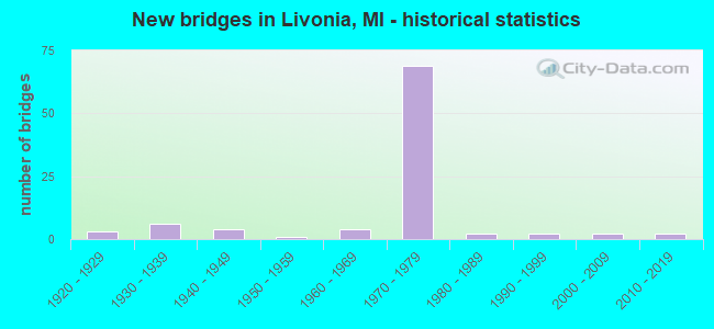
- New bridges - historical statistics
- 31920-1929
- 61930-1939
- 41940-1949
- 11950-1959
- 41960-1969
- 691970-1979
- 21980-1989
- 21990-1999
- 22000-2009
- 22010-2019

- Reconstructed bridges - Historical Statistics
- 11950-1959
- 31960-1969
- 01970-1979
- 21980-1989
- 21990-1999
- 202000-2009


- Bridge Condition - Deck
- 26.4%Very good
- 34.0%Good
- 15.1%Satisfactory
- 15.1%Fair
- 5.7%Poor
- 3.8%Serious

- Bridge Condition - Superstructure
- 13.2%Very good
- 49.1%Good
- 17.0%Satisfactory
- 11.3%Fair
- 5.7%Poor
- 3.8%Serious

- Bridge Condition - Substructure
- 30.2%Very good
- 30.2%Good
- 28.3%Satisfactory
- 9.4%Fair
- 1.9%Serious

- Bridge Condition - Channel
- 15.0%Good
- 45.0%Satisfactory
- 30.0%Fair
- 10.0%Poor

- Bridge Condition - Culverts
- 50.0%Good
- 50.0%Serious
Find on map >> Show street view
Structure Number: 11614, Location: IN LIVONIA (Lat: 42.410622, Lng: -83.423483), Route carried "on" structure: County highway 2057, Year Built: 1974, Status: Open, Structure Length: 9.36m (30.71ft), Average Daily Traffic: 17,600 (year 1977), Truck Traffic: 3%, Average Future Daily Traffic: 17,600 (year 1977), Design Load: HS 20, Features Intersected: I-96, Facility Carried by Structure: SIX MILE RD
Minimum Vertical Clearance: 30.48m (100.00ft), Kilometerpoint: 10.459, Lanes on structure: 4, Lanes under structure: 10, Owner: State Highway Agency, Approaching Roadway Width: 18.2m (59.7ft), Skew: 20 degrees, Material/Design: Steel, Design/Construction: Stringer/Multi-beam, Number Of Spans In Main Unit: 4, Length of Maximum Span: 37.3m (122.4ft), Curb or Sidewalk Widths: Left: 1.8m (5.9ft), Right: 1.8m (5.9ft), Curb-To-Curb Width: 16.8m (55.1ft), Out-to-Out Width: 23.9m (78.4ft)
Condition: Deck: Satisfactory, Superstructure: Fair, Substructure: Fair, Operating Rating: 69.0 metric tons, Method Used To Determine Operating Rating: Load Factor (LF) rating reported by rating factor (RF) method using MS18 loading, Inventory Rating: 41.1 metric tons, Method Used To Determine Inventory Rating: Load Factor (LF) rating reported by rating factor (RF) method using MS18 loading, Structural Evaluation: Somewhat better than minimum adequacy, Deck Geometry: Somewhat better than minimum adequacy, Underclear: Somewhat better than minimum adequacy, Approach Roadway Alignment: Equal to present desirable criteria, Designated Inspection Frequency: Every 24 months, Inspection Date: October 2020, Deck Structure Type: Concrete Cast-file-Place, Wearing Surface/Protective System: Wearing Surface: Monolithic Concrete
Find on map >> Show street view
Structure Number: 11976, Location: LIVONIA (Lat: 42.395969, Lng: -83.430847), Route carried "on" structure: County highway 2057, Year Built: 1971, Status: Open, Structure Length: 18.11m (59.42ft), Average Daily Traffic: 6,840 (year 1974), Average Future Daily Traffic: 6,840 (year 1977), Design Load: HS 20, Features Intersected: I-96, Facility Carried by Structure: FIVE MI RD
Minimum Vertical Clearance: 30.48m (100.00ft), Kilometerpoint: 3.135, Lanes on structure: 5, Lanes under structure: 10, Owner: State Highway Agency, Approaching Roadway Width: 25.6m (84.0ft), Skew: 2 degrees, Material/Design: Steel, Design/Construction: Stringer/Multi-beam, Number Of Spans In Main Unit: 6, Length of Maximum Span: 47.8m (156.8ft), Curb or Sidewalk Widths: Left: 1.8m (5.9ft), Right: 1.8m (5.9ft), Curb-To-Curb Width: 18.2m (59.7ft), Out-to-Out Width: 22.6m (74.1ft)
Condition: Deck: Fair, Superstructure: Satisfactory, Substructure: Satisfactory, Operating Rating: 86.8 metric tons, Method Used To Determine Operating Rating: Load Factor (LF) rating reported by rating factor (RF) method using MS18 loading, Inventory Rating: 51.8 metric tons, Method Used To Determine Inventory Rating: Load Factor (LF) rating reported by rating factor (RF) method using MS18 loading, Structural Evaluation: Equal to present minimum criteria, Deck Geometry: High priority of replacement, Underclear: Better than present minimum criteria, Approach Roadway Alignment: Equal to present desirable criteria, Designated Inspection Frequency: Every 24 months, Inspection Date: October 2020, Deck Structure Type: Concrete Cast-file-Place, Wearing Surface/Protective System: Wearing Surface: Monolithic Concrete
Find on map >> Show street view
Structure Number: 11977, Location: W LIMITS OF LIVONIA (Lat: 42.385939, Lng: -83.431550), Route carried "on" structure: Ramp Interstate 96, Year Built: 1971, Status: Open, Structure Length: 8.41m (27.59ft), Average Daily Traffic: 7,950 (year 1982), Average Future Daily Traffic: 7,950 (year 2020), Design Load: HS 20, Features Intersected: M-14 WB
Minimum Vertical Clearance: 30.48m (100.00ft), Kilometerpoint: 1.257, Lanes on structure: 2, Lanes under structure: 3, Owner: State Highway Agency, Approaching Roadway Width: 14.3m (46.9ft), Skew: 6 degrees, Material/Design: Steel, Design/Construction: Stringer/Multi-beam, Number Of Spans In Main Unit: 3, Length of Maximum Span: 53.6m (175.9ft), Curb-To-Curb Width: 12.3m (40.4ft), Out-to-Out Width: 13.3m (43.6ft)
Condition: Deck: Satisfactory, Superstructure: Satisfactory, Substructure: Satisfactory, Operating Rating: 58.0 metric tons, Method Used To Determine Operating Rating: Load Factor (LF) rating reported by rating factor (RF) method using MS18 loading, Inventory Rating: 34.7 metric tons, Method Used To Determine Inventory Rating: Load Factor (LF) rating reported by rating factor (RF) method using MS18 loading, Structural Evaluation: Equal to present minimum criteria, Deck Geometry: Superior to present desirable criteria, Underclear: Meets minimum limits, Approach Roadway Alignment: Equal to present minimum criteria, Designated Inspection Frequency: Every 24 months, Inspection Date: October 2020, Deck Structure Type: Concrete Cast-file-Place, Wearing Surface/Protective System: Wearing Surface: Latex Concrete
Find on map >> Show street view
Structure Number: 12089, Location: LIVONIA E/MIDDLE BELT (Lat: 42.412742, Lng: -83.330469), Route carried "on" structure: County highway 2057, Year Built: 1976, Status: Open, Structure Length: 2.43m (7.97ft), Average Daily Traffic: 19,968 (year 1997), Truck Traffic: 5%, Average Future Daily Traffic: 19,379 (year 2015), Design Load: HS 20+Mod, Features Intersected: TARABUSI DRAIN, Facility Carried by Structure: SIX MILE ROAD
Minimum Vertical Clearance: 30.48m (100.00ft), Kilometerpoint: 18.156, Lanes on structure: 5, Base Highway Network: Yes (Inventory Route: 168, Subroute: 1), Owner: County Highway Agency, Approaching Roadway Width: 18.9m (62.0ft), Skew: 1 degrees, Material/Design: Steel continuous, Design/Construction: Stringer/Multi-beam, Number Of Spans In Main Unit: 3, Length of Maximum Span: 9.1m (29.9ft), Curb or Sidewalk Widths: Left: 3.0m (9.8ft), Right: 3.0m (9.8ft), Curb-To-Curb Width: 18.7m (61.4ft), Out-to-Out Width: 25.7m (84.3ft)
Condition: Deck: Good, Superstructure: Good, Substructure: Satisfactory, Channel: Satisfactory, Operating Rating: 47.3 metric tons, Method Used To Determine Operating Rating: Load Factor (LF) rating reported by rating factor (RF) method using MS18 loading, Inventory Rating: 28.2 metric tons, Method Used To Determine Inventory Rating: Load Factor (LF) rating reported by rating factor (RF) method using MS18 loading, Structural Evaluation: Equal to present minimum criteria, Deck Geometry: High priority of corrective action, Waterway Adequacy: Superior to present desirable criteria, Approach Roadway Alignment: Equal to present desirable criteria, Designated Inspection Frequency: Every 24 months, Inspection Date: June 2021, Deck Structure Type: Concrete Cast-file-Place, Wearing Surface/Protective System: Wearing Surface: Monolithic Concrete
Find on map >> Show street view
Structure Number: 12095, Location: LIVONIA W/MERRIMAN (Lat: 42.426428, Lng: -83.363419), Route carried "on" structure: County highway 2057, Year Built: 2007, Status: Open, Structure Length: 0.67m (2.20ft), Average Daily Traffic: 21,183 (year 2004), Truck Traffic: 5%, Average Future Daily Traffic: 22,616 (year 2015), Design Load: HS 20+Mod, Features Intersected: TARABUSI DRAIN, Facility Carried by Structure: SEVEN MILE ROAD
Minimum Vertical Clearance: 30.48m (100.00ft), Kilometerpoint: 5.734, Lanes on structure: 5, Base Highway Network: Yes (Inventory Route: 170, Subroute: 6), Owner: County Highway Agency, Approaching Roadway Width: 19.2m (63.0ft), Material/Design: Concrete, Design/Construction: Culvert, Number Of Spans In Main Unit: 1, Length of Maximum Span: 6.7m (22.0ft), Curb-To-Curb Width: 19.2m (63.0ft), Out-to-Out Width: 23.2m (76.1ft)
Condition: Channel: Satisfactory, Culverts: Good, Operating Rating: 54.6 metric tons, Method Used To Determine Operating Rating: Field evaluation and documented engineering judgment, Inventory Rating: 32.7 metric tons, Method Used To Determine Inventory Rating: Field evaluation and documented engineering judgment, Structural Evaluation: Better than present minimum criteria, Deck Geometry: Meets minimum limits, Waterway Adequacy: Equal to present minimum criteria, Approach Roadway Alignment: Equal to present desirable criteria, Designated Inspection Frequency: Every 24 months, Inspection Date: June 2021, Deck Structure Type: Concrete Precast Panels, Wearing Surface/Protective System: Wearing Surface: Monolithic Concrete
Find on map >> Show street view
Structure Number: 12096, Location: LIVONIA W/INKSTER (Lat: 42.427525, Lng: -83.319386), Route carried "on" structure: County highway 2057, Year Built: 1928, Year Reconstructed: 2004, Status: Open, Structure Length: 1.03m (3.38ft), Average Daily Traffic: 23,213 (year 1995), Truck Traffic: 5%, Average Future Daily Traffic: 20,132 (year 2015), Design Load: HS 20+Mod, Features Intersected: UPPER ROUGE RIVER, Facility Carried by Structure: SEVEN MILE ROAD
Minimum Vertical Clearance: 30.48m (100.00ft), Kilometerpoint: 9.359, Lanes on structure: 4, Base Highway Network: Yes (Inventory Route: 170, Subroute: 6), Owner: County Highway Agency, Approaching Roadway Width: 17.0m (55.8ft), Material/Design: Concrete, Design/Construction: Box Beam or Girders - Multiple, Number Of Spans In Main Unit: 1, Length of Maximum Span: 9.7m (31.8ft), Curb or Sidewalk Widths: Left: 1.8m (5.9ft), Right: 1.8m (5.9ft), Curb-To-Curb Width: 12.2m (40.0ft), Out-to-Out Width: 17.0m (55.8ft)
Condition: Deck: Good, Superstructure: Very good, Substructure: Good, Channel: Satisfactory, Operating Rating: 84.6 metric tons, Method Used To Determine Operating Rating: Load Factor (LF) rating reported by rating factor (RF) method using MS18 loading, Inventory Rating: 50.5 metric tons, Method Used To Determine Inventory Rating: Load Factor (LF) rating reported by rating factor (RF) method using MS18 loading, Structural Evaluation: Better than present minimum criteria, Deck Geometry: High priority of replacement, Waterway Adequacy: Equal to present minimum criteria, Approach Roadway Alignment: Equal to present desirable criteria, Designated Inspection Frequency: Every 24 months, Inspection Date: June 2021, Deck Structure Type: Concrete Cast-file-Place, Wearing Surface/Protective System: Wearing Surface: Bituminous
Find on map >> Show street view
Structure Number: 12144, Location: LIVONIA N/ANN ARBR TRL (Lat: 42.358442, Lng: -83.386475), Route carried "on" structure: County highway 2057, Year Built: 1947, Status: Open, Structure Length: 4.29m (14.07ft), Average Daily Traffic: 27,486 (year 1997), Truck Traffic: 5%, Average Future Daily Traffic: 26,754 (year 2015), Design Load: HS 20+Mod, Features Intersected: E N HINES DRIVE, Facility Carried by Structure: WAYNE ROAD
Minimum Vertical Clearance: 30.48m (100.00ft), Kilometerpoint: 19.021, Lanes on structure: 4, Lanes under structure: 2, Base Highway Network: Yes (Inventory Route: 471, Subroute: 70), Owner: County Highway Agency, Approaching Roadway Width: 18.2m (59.7ft), Material/Design: Concrete continuous, Design/Construction: Frame, Number Of Spans In Main Unit: 2, Length of Maximum Span: 20.1m (65.9ft), Curb or Sidewalk Widths: Left: 1.8m (5.9ft), Right: 1.8m (5.9ft), Curb-To-Curb Width: 14.6m (47.9ft), Out-to-Out Width: 18.9m (62.0ft)
Condition: Deck: Poor, Superstructure: Poor, Substructure: Satisfactory, Channel: Satisfactory, Operating Rating: 47.0 metric tons, Method Used To Determine Operating Rating: Load Factor (LF) rating reported by rating factor (RF) method using MS18 loading, Inventory Rating: 28.2 metric tons, Method Used To Determine Inventory Rating: Load Factor (LF) rating reported by rating factor (RF) method using MS18 loading, Structural Evaluation: Meets minimum limits, Deck Geometry: High priority of replacement, Underclear: High priority of corrective action, Waterway Adequacy: Equal to present desirable criteria, Approach Roadway Alignment: Equal to present desirable criteria, Designated Inspection Frequency: Every 12 months, Inspection Date: May 2021, Deck Structure Type: Concrete Cast-file-Place, Wearing Surface/Protective System: Wearing Surface: Integral Concrete, Deck Protection: Epoxy Coated Reinforcing
Find on map >> Show street view
Structure Number: 12146, Location: LIVONIA N/FIVE MILE (Lat: 42.404253, Lng: -83.373897), Route carried "on" structure: County highway 2057, Year Built: 1967, Status: Posted for load, Structure Length: 2.86m (9.38ft), Average Daily Traffic: 41,944 (year 1995), Truck Traffic: 5%, Average Future Daily Traffic: 26,184 (year 2015), Design Load: HS 20+Mod, Features Intersected: BELL CREEK, Facility Carried by Structure: FARMINGTON ROAD
Minimum Vertical Clearance: 30.48m (100.00ft), Kilometerpoint: 6.034, Lanes on structure: 5, Base Highway Network: Yes (Inventory Route: 169, Subroute: 2), Owner: County Highway Agency, Approaching Roadway Width: 18.2m (59.7ft), Skew: 3 degrees, Material/Design: Concrete continuous, Design/Construction: Slab, Number Of Spans In Main Unit: 3, Length of Maximum Span: 11.2m (36.7ft), Curb or Sidewalk Widths: Left: 1.8m (5.9ft), Right: 1.8m (5.9ft), Curb-To-Curb Width: 18.2m (59.7ft), Out-to-Out Width: 22.5m (73.8ft)
Condition: Deck: Fair, Superstructure: Fair, Substructure: Satisfactory, Channel: Fair, Operating Rating: 42.8 metric tons, Method Used To Determine Operating Rating: Load Factor (LF) rating reported by rating factor (RF) method using MS18 loading, Inventory Rating: 25.6 metric tons, Method Used To Determine Inventory Rating: Load Factor (LF) rating reported by rating factor (RF) method using MS18 loading, Structural Evaluation: Somewhat better than minimum adequacy, Deck Geometry: High priority of replacement, Waterway Adequacy: Equal to present desirable criteria, Approach Roadway Alignment: Equal to present desirable criteria, Bridge Posting: Required (Relationship of Operating Rating to Maximum Legal Load: 10.0 - 19.9% below), Designated Inspection Frequency: Every 24 months, Inspection Date: June 2021, Deck Structure Type: Concrete Cast-file-Place, Wearing Surface/Protective System: Wearing Surface: Monolithic Concrete
Find on map >> Show street view
Structure Number: 12147, Location: LIVONIA N/SEVEN MILE (Lat: 42.431389, Lng: -83.375142), Route carried "on" structure: County highway 2057, Year Built: 1922, Year Reconstructed: 1967, Status: Open, Structure Length: 1.04m (3.41ft), Average Daily Traffic: 29,240 (year 2017), Truck Traffic: 13%, Average Future Daily Traffic: 29,300 (year 2037), Design Load: HS 20+Mod, Features Intersected: TARABUSI DRAIN, Facility Carried by Structure: FARMINGTON ROAD
Minimum Vertical Clearance: 30.48m (100.00ft), Kilometerpoint: 9.048, Lanes on structure: 5, Base Highway Network: Yes (Inventory Route: 169, Subroute: 2), Owner: County Highway Agency, Approaching Roadway Width: 18.2m (59.7ft), Material/Design: Concrete, Design/Construction: Tee Beam, Number Of Spans In Main Unit: 1, Length of Maximum Span: 9.1m (29.9ft), Curb or Sidewalk Widths: Left: 1.8m (5.9ft), Right: 1.8m (5.9ft), Curb-To-Curb Width: 18.3m (60.0ft), Out-to-Out Width: 22.6m (74.1ft)
Condition: Deck: Fair, Superstructure: Satisfactory, Substructure: Fair, Channel: Poor, Operating Rating: 57.7 metric tons, Method Used To Determine Operating Rating: Load Factor (LF) rating reported by rating factor (RF) method using MS18 loading, Inventory Rating: 34.7 metric tons, Method Used To Determine Inventory Rating: Load Factor (LF) rating reported by rating factor (RF) method using MS18 loading, Structural Evaluation: Somewhat better than minimum adequacy, Deck Geometry: High priority of replacement, Waterway Adequacy: Superior to present desirable criteria, Approach Roadway Alignment: Equal to present desirable criteria, Designated Inspection Frequency: Every 24 months, Inspection Date: June 2021, Deck Structure Type: Concrete Cast-file-Place, Wearing Surface/Protective System: Wearing Surface: Epoxy Overlay, Deck Protection: Epoxy Coated Reinforcing
Find on map >> Show street view
Structure Number: 12153, Location: LIVONIA S/SIX MILE (Lat: 42.405875, Lng: -83.354436), Route carried "on" structure: County highway 2057, Year Built: 1935, Year Reconstructed: 1965, Status: Open, Structure Length: 1.92m (6.30ft), Average Daily Traffic: 29,494 (year 1997), Truck Traffic: 5%, Average Future Daily Traffic: 25,696 (year 2015), Design Load: HS 20, Features Intersected: BELL CREEK, Facility Carried by Structure: MERRIMAN ROAD
Minimum Vertical Clearance: 30.48m (100.00ft), Kilometerpoint: 21.191, Lanes on structure: 5, Base Highway Network: Yes, Owner: County Highway Agency, Approaching Roadway Width: 18.2m (59.7ft), Material/Design: Prestressed concrete, Design/Construction: Stringer/Multi-beam, Number Of Spans In Main Unit: 2, Length of Maximum Span: 8.8m (28.9ft), Curb or Sidewalk Widths: Left: 1.8m (5.9ft), Right: 1.8m (5.9ft), Curb-To-Curb Width: 18.2m (59.7ft), Out-to-Out Width: 22.5m (73.8ft)
Condition: Deck: Satisfactory, Superstructure: Satisfactory, Substructure: Fair, Channel: Poor, Operating Rating: 54.1 metric tons, Method Used To Determine Operating Rating: Load Factor (LF) rating reported by rating factor (RF) method using MS18 loading, Inventory Rating: 32.4 metric tons, Method Used To Determine Inventory Rating: Load Factor (LF) rating reported by rating factor (RF) method using MS18 loading, Structural Evaluation: Somewhat better than minimum adequacy, Deck Geometry: High priority of replacement, Waterway Adequacy: Equal to present desirable criteria, Approach Roadway Alignment: Equal to present desirable criteria, Designated Inspection Frequency: Every 24 months, Inspection Date: June 2021, Deck Structure Type: Concrete Cast-file-Place, Wearing Surface/Protective System: Wearing Surface: Integral Concrete, Deck Protection: Epoxy Coated Reinforcing
Find on map >> Show street view
Structure Number: 12154, Location: LIVONIA S/SEVEN MILE (Lat: 42.420583, Lng: -83.355075), Route carried "on" structure: County highway 2057, Year Built: 1935, Year Reconstructed: 1965, Status: Posted for load, Structure Length: 1.95m (6.40ft), Average Daily Traffic: 26,616 (year 1997), Truck Traffic: 5%, Average Future Daily Traffic: 23,035 (year 2015), Design Load: HS 20+Mod, Features Intersected: TARABUSI DRAIN, Facility Carried by Structure: MERRIMAN ROAD
Minimum Vertical Clearance: 30.48m (100.00ft), Kilometerpoint: 22.825, Lanes on structure: 2, Base Highway Network: Yes, Owner: County Highway Agency, Approaching Roadway Width: 18.3m (60.0ft), Material/Design: Concrete continuous, Design/Construction: Slab, Number Of Spans In Main Unit: 3, Length of Maximum Span: 7.3m (24.0ft), Curb or Sidewalk Widths: Left: 1.8m (5.9ft), Right: 1.8m (5.9ft), Curb-To-Curb Width: 18.3m (60.0ft), Out-to-Out Width: 22.5m (73.8ft)
Condition: Deck: Serious, Superstructure: Serious, Substructure: Satisfactory, Channel: Good, Operating Rating: 24.0 metric tons, Method Used To Determine Operating Rating: Load Factor (LF) rating reported by rating factor (RF) method using MS18 loading, Inventory Rating: 14.3 metric tons, Method Used To Determine Inventory Rating: Load Factor (LF) rating reported by rating factor (RF) method using MS18 loading, Structural Evaluation: High priority of corrective action, Deck Geometry: Superior to present desirable criteria, Waterway Adequacy: Equal to present desirable criteria, Approach Roadway Alignment: Equal to present desirable criteria, Bridge Posting: Required (Relationship of Operating Rating to Maximum Legal Load: > 39.9% below), Designated Inspection Frequency: Every 12 months, Inspection Date: May 2021, Deck Structure Type: Concrete Cast-file-Place, Wearing Surface/Protective System: Wearing Surface: Monolithic Concrete
Find on map >> Show street view
Structure Number: 12161, Location: LIVONIA N/FIVE MILE (Lat: 42.408692, Lng: -83.335028), Route carried "on" structure: County highway 2057, Year Built: 1930, Year Reconstructed: 1991, Status: Posted for load, Structure Length: 1.92m (6.30ft), Average Daily Traffic: 39,364 (year 1996), Truck Traffic: 7%, Average Future Daily Traffic: 49,561 (year 2015), Design Load: H 20, Features Intersected: BELL CREEK, Facility Carried by Structure: MIDDLE BELT ROAD
Minimum Vertical Clearance: 30.48m (100.00ft), Kilometerpoint: 32.417, Lanes on structure: 5, Base Highway Network: Yes (Inventory Route: 167, Subroute: 3), Owner: County Highway Agency, Approaching Roadway Width: 18.2m (59.7ft), Material/Design: Prestressed concrete, Design/Construction: Stringer/Multi-beam, Number Of Spans In Main Unit: 2, Length of Maximum Span: 9.1m (29.9ft), Curb or Sidewalk Widths: Left: 1.6m (5.2ft), Right: 2.4m (7.9ft), Curb-To-Curb Width: 18.2m (59.7ft), Out-to-Out Width: 22.5m (73.8ft)
Condition: Deck: Serious, Superstructure: Serious, Substructure: Satisfactory, Channel: Fair, Operating Rating: 30.1 metric tons, Method Used To Determine Operating Rating: Load Factor (LF) rating reported by rating factor (RF) method using MS18 loading, Inventory Rating: 18.1 metric tons, Method Used To Determine Inventory Rating: Load Factor (LF) rating reported by rating factor (RF) method using MS18 loading, Structural Evaluation: High priority of corrective action, Deck Geometry: High priority of replacement, Waterway Adequacy: Equal to present desirable criteria, Approach Roadway Alignment: Equal to present desirable criteria, Bridge Posting: Required (Relationship of Operating Rating to Maximum Legal Load: > 39.9% below), Designated Inspection Frequency: Every 12 months, Inspection Date: May 2021, Deck Structure Type: Concrete Cast-file-Place, Wearing Surface/Protective System: Wearing Surface: Integral Concrete, Deck Protection: Epoxy Coated Reinforcing
Find on map >> Show street view
Structure Number: 12162, Location: LIVONIA N/SIX MILE (Lat: 42.415447, Lng: -83.335314), Route carried "on" structure: County highway 2057, Year Built: 1930, Year Reconstructed: 1992, Status: Open, Structure Length: 1.18m (3.87ft), Average Daily Traffic: 40,170 (year 1996), Truck Traffic: 7%, Average Future Daily Traffic: 41,573 (year 2015), Design Load: HS 20+Mod, Features Intersected: TARABUSI DRAIN, Facility Carried by Structure: MIDDLE BELT ROAD
Minimum Vertical Clearance: 30.48m (100.00ft), Kilometerpoint: 33.168, Lanes on structure: 5, Base Highway Network: Yes (Inventory Route: 167, Subroute: 3), Owner: County Highway Agency, Approaching Roadway Width: 18.2m (59.7ft), Skew: 3 degrees, Material/Design: Steel continuous, Design/Construction: Stringer/Multi-beam, Number Of Spans In Main Unit: 1, Length of Maximum Span: 10.6m (34.8ft), Curb or Sidewalk Widths: Left: 1.4m (4.6ft), Right: 1.4m (4.6ft), Curb-To-Curb Width: 18.3m (60.0ft), Out-to-Out Width: 22.0m (72.2ft)
Condition: Deck: Fair, Superstructure: Fair, Substructure: Fair, Channel: Satisfactory, Operating Rating: 57.0 metric tons, Method Used To Determine Operating Rating: Load Factor (LF) rating reported by rating factor (RF) method using MS18 loading, Inventory Rating: 34.0 metric tons, Method Used To Determine Inventory Rating: Load Factor (LF) rating reported by rating factor (RF) method using MS18 loading, Structural Evaluation: Somewhat better than minimum adequacy, Deck Geometry: High priority of replacement, Waterway Adequacy: Equal to present desirable criteria, Approach Roadway Alignment: Equal to present desirable criteria, Designated Inspection Frequency: Every 24 months, Inspection Date: May 2021, Deck Structure Type: Concrete Cast-file-Place, Wearing Surface/Protective System: Wearing Surface: Bituminous
Find on map >> Show street view
Structure Number: 1217, Location: LIVONIA/REDFORD N/5 MILE (Lat: 42.405458, Lng: -83.315258), Route carried "on" structure: County highway 2057, Year Built: 1958, Status: Open, Structure Length: 2.78m (9.12ft), Average Daily Traffic: 18,960 (year 2019), Truck Traffic: 11%, Average Future Daily Traffic: 19,000 (year 2039), Design Load: HS 20, Features Intersected: BELL CREEK, Facility Carried by Structure: INKSTER ROAD
Minimum Vertical Clearance: 30.48m (100.00ft), Kilometerpoint: 33.123, Lanes on structure: 2, Owner: County Highway Agency, Approaching Roadway Width: 13.4m (44.0ft), Skew: 2 degrees, Material/Design: Concrete continuous, Design/Construction: Slab, Number Of Spans In Main Unit: 3, Length of Maximum Span: 10.7m (35.1ft), Curb or Sidewalk Widths: Left: 1.8m (5.9ft), Right: 1.8m (5.9ft), Curb-To-Curb Width: 15.8m (51.8ft), Out-to-Out Width: 20.1m (65.9ft)
Condition: Deck: Poor, Superstructure: Poor, Substructure: Satisfactory, Channel: Good, Operating Rating: 74.8 metric tons, Method Used To Determine Operating Rating: Load Factor (LF) rating reported by rating factor (RF) method using MS18 loading, Inventory Rating: 44.7 metric tons, Method Used To Determine Inventory Rating: Load Factor (LF) rating reported by rating factor (RF) method using MS18 loading, Structural Evaluation: Meets minimum limits, Deck Geometry: Superior to present desirable criteria, Waterway Adequacy: Equal to present desirable criteria, Approach Roadway Alignment: Equal to present desirable criteria, Designated Inspection Frequency: Every 12 months, Inspection Date: April 2021, Deck Structure Type: Concrete Cast-file-Place, Wearing Surface/Protective System: Wearing Surface: Epoxy Overlay, Deck Protection: Epoxy Coated Reinforcing
Find on map >> Show street view
Structure Number: 12171, Location: LIVONIA/REDFORD S/7 MILE (Lat: 42.424294, Lng: -83.316078), Route carried "on" structure: County highway 2057, Year Built: 1995, Status: Open, Structure Length: 1.83m (6.00ft), Average Daily Traffic: 15,580 (year 2018), Truck Traffic: 2%, Average Future Daily Traffic: 15,610 (year 2038), Design Load: HS 25 or greater, Features Intersected: UPPER ROUGE RIVER, Facility Carried by Structure: INKSTER ROAD
Minimum Vertical Clearance: 30.48m (100.00ft), Kilometerpoint: 35.217, Lanes on structure: 4, Owner: County Highway Agency, Approaching Roadway Width: 15.2m (49.9ft), Skew: 7 degrees, Material/Design: Prestressed concrete, Design/Construction: Box Beam or Girders - Multiple, Number Of Spans In Main Unit: 1, Length of Maximum Span: 17.0m (55.8ft), Curb or Sidewalk Widths: Left: 2.0m (6.6ft), Right: 2.0m (6.6ft), Curb-To-Curb Width: 15.2m (49.9ft), Out-to-Out Width: 20.0m (65.6ft)
Condition: Deck: Satisfactory, Superstructure: Good, Substructure: Good, Channel: Satisfactory, Operating Rating: 97.2 metric tons, Method Used To Determine Operating Rating: Load Factor (LF) rating reported by rating factor (RF) method using MS18 loading, Inventory Rating: 69.3 metric tons, Method Used To Determine Inventory Rating: Load Factor (LF) rating reported by rating factor (RF) method using MS18 loading, Structural Evaluation: Better than present minimum criteria, Deck Geometry: High priority of corrective action, Waterway Adequacy: Equal to present desirable criteria, Approach Roadway Alignment: Equal to present desirable criteria, Designated Inspection Frequency: Every 24 months, Inspection Date: June 2021, Deck Structure Type: Concrete Cast-file-Place, Wearing Surface/Protective System: Wearing Surface: Epoxy Overlay, Deck Protection: Epoxy Coated Reinforcing
Find on map >> Show street view
Structure Number: 123, Location: LIVONIA S/E N HINES DRIVE (Lat: 42.360414, Lng: -83.400794), Route carried "on" structure: County highway , Year Built: 1931, Year Reconstructed: 1961, Status: Closed, Structure Length: 1.09m (3.58ft), Average Daily Traffic: 400 (year 1987), Average Future Daily Traffic: 440 (year 2015), Design Load: H 20, Features Intersected: MIDDLE ROUGE RIVER, Facility Carried by Structure: RIVERVIEW DRIVE
Minimum Vertical Clearance: 30.48m (100.00ft), Kilometerpoint: 0.185, Lanes on structure: 1, Owner: Local Agency, Maintenance Responsibility: County Highway Agency, Approaching Roadway Width: 7.3m (24.0ft), Material/Design: Steel, Design/Construction: Stringer/Multi-beam, Number Of Spans In Main Unit: 1, Length of Maximum Span: 10.0m (32.8ft), Curb-To-Curb Width: 4.2m (13.8ft), Out-to-Out Width: 4.8m (15.7ft)
Condition: Deck: Fair, Superstructure: Fair, Substructure: Serious, Channel: Fair, Operating Rating: 21.7 metric tons, Method Used To Determine Operating Rating: Load Factor (LF) rating reported by rating factor (RF) method using MS18 loading, Inventory Rating: 13.0 metric tons, Method Used To Determine Inventory Rating: Load Factor (LF) rating reported by rating factor (RF) method using MS18 loading, Structural Evaluation: High priority of corrective action, Waterway Adequacy: Equal to present minimum criteria, Approach Roadway Alignment: Equal to present minimum criteria, Bridge Posting: Required (Relationship of Operating Rating to Maximum Legal Load: > 39.9% below), Designated Inspection Frequency: Every 12 months, Inspection Date: June 2021, Deck Structure Type: Concrete Cast-file-Place, Wearing Surface/Protective System: Wearing Surface: Monolithic Concrete
Find on map >> Show street view
Structure Number: 12508, Location: HUBBARD RD @ BELL CREEK (Lat: 42.403081, Lng: -83.364097), Route carried "on" structure: City street , Year Built: 1960, Year Reconstructed: 2004, Status: Open, Structure Length: 2.77m (9.09ft), Average Daily Traffic: 3,267 (year 1990), Average Future Daily Traffic: 4,000 (year 2010), Design Load: HS 20+Mod, Features Intersected: BELL CREEK, Facility Carried by Structure: HUBBARD ROAD
Minimum Vertical Clearance: 30.48m (100.00ft), Kilometerpoint: 2.229, Lanes on structure: 2, Owner: City or Municipal Highway Agency, Approaching Roadway Width: 7.3m (24.0ft), Material/Design: Concrete, Design/Construction: Slab, Number Of Spans In Main Unit: 3, Length of Maximum Span: 10.6m (34.8ft), Curb or Sidewalk Widths: Left: 1.6m (5.2ft), Right: 1.6m (5.2ft), Curb-To-Curb Width: 10.1m (33.1ft), Out-to-Out Width: 14.0m (45.9ft)
Condition: Deck: Satisfactory, Superstructure: Satisfactory, Substructure: Satisfactory, Channel: Satisfactory, Operating Rating: 68.4 metric tons, Method Used To Determine Operating Rating: Load Factor (LF) rating reported by rating factor (RF) method using MS18 loading, Inventory Rating: 40.8 metric tons, Method Used To Determine Inventory Rating: Load Factor (LF) rating reported by rating factor (RF) method using MS18 loading, Structural Evaluation: Equal to present minimum criteria, Deck Geometry: Meets minimum limits, Waterway Adequacy: Better than present minimum criteria, Approach Roadway Alignment: Equal to present desirable criteria, Length Of Structure Improvement: 2.74m (8.99ft), Designated Inspection Frequency: Every 24 months, Inspection Date: October 2020, Bridge Improvement Cost: $50,000, Roadway Improvement Cost: $10,000, Total Project Cost: $60,000, Deck Structure Type: Concrete Cast-file-Place, Wearing Surface/Protective System: Wearing Surface: Bituminous
Find on map >> Show street view
Structure Number: 12509, Location: NEWBURGH RD @ ROUGE RIVER (Lat: 42.366611, Lng: -83.411275), Route carried "on" structure: City street 2057, Year Built: 1989, Status: Open, Structure Length: 1.82m (5.97ft), Average Daily Traffic: 19,535 (year 1990), Truck Traffic: 5%, Average Future Daily Traffic: 25,000 (year 2010), Design Load: HS 20, Features Intersected: ROUGE RIVER, Facility Carried by Structure: NEWBURGH ROAD
Minimum Vertical Clearance: 30.48m (100.00ft), Kilometerpoint: 9.668, Lanes on structure: 5, Owner: City or Municipal Highway Agency, Approaching Roadway Width: 18.9m (62.0ft), Material/Design: Prestressed concrete, Design/Construction: Box Beam or Girders - Multiple, Number Of Spans In Main Unit: 1, Length of Maximum Span: 17.0m (55.8ft), Curb or Sidewalk Widths: Left: 2.4m (7.9ft), Right: 2.4m (7.9ft), Curb-To-Curb Width: 18.9m (62.0ft), Out-to-Out Width: 24.6m (80.7ft)
Condition: Deck: Satisfactory, Superstructure: Good, Substructure: Good, Channel: Good, Operating Rating: 54.5 metric tons, Method Used To Determine Operating Rating: Field evaluation and documented engineering judgment, Inventory Rating: 32.7 metric tons, Method Used To Determine Inventory Rating: Field evaluation and documented engineering judgment, Structural Evaluation: Better than present minimum criteria, Deck Geometry: Meets minimum limits, Waterway Adequacy: Superior to present desirable criteria, Approach Roadway Alignment: Equal to present desirable criteria, Designated Inspection Frequency: Every 24 months, Inspection Date: October 2020, Deck Structure Type: Concrete Precast Panels, Wearing Surface/Protective System: Wearing Surface: Monolithic Concrete, Deck Protection: Epoxy Coated Reinforcing
Find on map >> Show street view
Structure Number: 11348, Location: IN LIVONIA (Lat: 42.366722, Lng: -83.408275), Route carried "under" structure: State highway 14, Year Built: 1948, Structure Length: 0. m, Average Daily Traffic: 25,314 (year 2007), Truck Traffic: 3%, Features Intersected: OLD M-14 (ANN ARBOR RD), Facility Carried by Structure: HINES DRIVE
Minimum Vertical Clearance: 4.65m (15.26ft), Kilometerpoint: 12.022, Lanes on structure: 4, Lanes under structure: 2, Material/Design: Concrete, Design/Construction: Frame, Length of Maximum Span: 22.2m (72.8ft)
Find on map >> Show street view
Structure Number: 11354, Location: 0.6MI W OF W LTS LIVONIA (Lat: 42.387078, Lng: -83.443800), Route carried "under" structure: State highway 14, Year Built: 1977, Structure Length: 0. m, Average Daily Traffic: 93,826 (year 2007), Truck Traffic: 6%, Features Intersected: M-14, Facility Carried by Structure: HAGGERTY ROAD
Minimum Vertical Clearance: 5.23m (17.16ft), Kilometerpoint: 9.676, Lanes on structure: 4, Lanes under structure: 8, Material/Design: Steel, Design/Construction: Stringer/Multi-beam, Length of Maximum Span: 31.4m (103.0ft)
Find on map >> Show street view
Structure Number: 11487, Location: IN LIVONIA (Lat: 42.382439, Lng: -83.422439), Route carried "under" structure: Interstate 96, Year Built: 1972, Structure Length: 0. m, Average Daily Traffic: 131,900 (year 2012), Truck Traffic: 5%, Features Intersected: I-96, Facility Carried by Structure: SCHOOLCRAFT RD
Minimum Vertical Clearance: 4.67m (15.32ft), Kilometerpoint: 2.068, Lanes on structure: 2, Lanes under structure: 10, Material/Design: Steel, Design/Construction: Stringer/Multi-beam, Length of Maximum Span: 49.2m (161.4ft)
Find on map >> Show street view
Structure Number: 11488, Location: IN LIVONIA (Lat: 42.381556, Lng: -83.412014), Route carried "under" structure: Interstate 96, Year Built: 1974, Structure Length: 0. m, Average Daily Traffic: 131,900 (year 2012), Truck Traffic: 5%, Features Intersected: I-96, Facility Carried by Structure: NEWBURGH RD
Minimum Vertical Clearance: 4.90m (16.08ft), Kilometerpoint: 2.997, Lanes on structure: 4, Lanes under structure: 8, Material/Design: Steel, Design/Construction: Stringer/Multi-beam, Length of Maximum Span: 26.8m (87.9ft)
Find on map >> Show street view
Structure Number: 11489, Location: IN LIVONIA (Lat: 42.381833, Lng: -83.402175), Route carried "under" structure: Interstate 96, Year Built: 1974, Structure Length: 0. m, Average Daily Traffic: 127,200 (year 2012), Truck Traffic: 5%, Features Intersected: I-96, Facility Carried by Structure: LEVAN RD
Minimum Vertical Clearance: 4.75m (15.58ft), Kilometerpoint: 3.808, Lanes on structure: 5, Lanes under structure: 8, Material/Design: Steel, Design/Construction: Stringer/Multi-beam, Length of Maximum Span: 26.8m (87.9ft)
Find on map >> Show street view
Structure Number: 1149, Location: IN LIVONIA (Lat: 42.382028, Lng: -83.392858), Route carried "under" structure: Interstate 96, Year Built: 1974, Structure Length: 0. m, Average Daily Traffic: 136,900 (year 2012), Truck Traffic: 5%, Features Intersected: I-96, Facility Carried by Structure: YALE AVE
Minimum Vertical Clearance: 4.67m (15.32ft), Kilometerpoint: 4.576, Lanes on structure: 2, Lanes under structure: 8, Material/Design: Steel, Design/Construction: Stringer/Multi-beam, Length of Maximum Span: 26.5m (86.9ft)
Find on map >> Show street view
Structure Number: 11491, Location: IN LIVONIA (Lat: 42.382561, Lng: -83.377894), Route carried "under" structure: Interstate 96, Year Built: 1974, Structure Length: 0. m, Average Daily Traffic: 136,900 (year 2012), Truck Traffic: 5%, Features Intersected: I-96, Facility Carried by Structure: STARK RD
Minimum Vertical Clearance: 4.55m (14.93ft), Kilometerpoint: 5.803, Lanes on structure: 4, Lanes under structure: 10, Material/Design: Steel, Design/Construction: Stringer/Multi-beam, Length of Maximum Span: 27.3m (89.6ft)
Find on map >> Show street view
Structure Number: 11492, Location: IN LIVONIA (Lat: 42.382386, Lng: -83.372928), Route carried "under" structure: Interstate 96, Year Built: 1974, Structure Length: 0. m, Average Daily Traffic: 136,900 (year 2012), Truck Traffic: 5%, Features Intersected: I-96, Facility Carried by Structure: FARMINGTON RD
Minimum Vertical Clearance: 4.47m (14.67ft), Kilometerpoint: 6.217, Lanes on structure: 5, Lanes under structure: 8, Material/Design: Steel, Design/Construction: Stringer/Multi-beam, Length of Maximum Span: 26.8m (87.9ft)
Find on map >> Show street view
Structure Number: 11493, Location: IN LIVONIA (Lat: 42.382572, Lng: -83.365708), Route carried "under" structure: Interstate 96, Year Built: 1974, Structure Length: 0. m, Average Daily Traffic: 144,000 (year 2012), Truck Traffic: 4%, Features Intersected: I-96, Facility Carried by Structure: BROOKFIELD AVE
Minimum Vertical Clearance: 4.52m (14.83ft), Kilometerpoint: 6.811, Lanes on structure: 2, Lanes under structure: 9, Material/Design: Steel, Design/Construction: Stringer/Multi-beam, Length of Maximum Span: 26.5m (86.9ft)
Find on map >> Show street view
Structure Number: 11494, Location: IN LIVONIA (Lat: 42.382719, Lng: -83.359150), Route carried "under" structure: Interstate 96, Year Built: 1974, Structure Length: 0. m, Average Daily Traffic: 144,000 (year 2012), Truck Traffic: 4%, Features Intersected: I-96, Facility Carried by Structure: BERWICK RD LFT TRN
Minimum Vertical Clearance: 4.70m (15.42ft), Kilometerpoint: 7.342, Lanes on structure: 2, Lanes under structure: 10, Material/Design: Steel, Design/Construction: Stringer/Multi-beam, Length of Maximum Span: 26.5m (86.9ft)
Find on map >> Show street view
Structure Number: 11495, Location: IN LIVONIA (Lat: 42.382850, Lng: -83.353331), Route carried "under" structure: Interstate 96, Year Built: 1974, Structure Length: 0. m, Average Daily Traffic: 157,688 (year 2007), Truck Traffic: 7%, Features Intersected: I-96, Facility Carried by Structure: MERRIMAN RD
Minimum Vertical Clearance: 4.67m (15.32ft), Kilometerpoint: 7.831, Lanes on structure: 5, Lanes under structure: 8, Material/Design: Steel, Design/Construction: Stringer/Multi-beam, Length of Maximum Span: 26.5m (86.9ft)
Find on map >> Show street view
Structure Number: 11496, Location: IN LIVONIA (Lat: 42.383014, Lng: -83.347208), Route carried "under" structure: Interstate 96, Year Built: 1974, Structure Length: 0. m, Average Daily Traffic: 145,800 (year 2012), Truck Traffic: 4%, Features Intersected: I-96, Facility Carried by Structure: WARNER COURT
Minimum Vertical Clearance: 4.44m (14.57ft), Kilometerpoint: 8.335, Lanes on structure: 2, Lanes under structure: 10, Material/Design: Steel, Design/Construction: Stringer/Multi-beam, Length of Maximum Span: 26.5m (86.9ft)
Find on map >> Show street view
Structure Number: 11497, Location: IN LIVONIA (Lat: 42.383339, Lng: -83.333700), Route carried "under" structure: Interstate 96, Year Built: 1971, Structure Length: 0. m, Average Daily Traffic: 145,800 (year 2012), Truck Traffic: 4%, Features Intersected: I-96, Facility Carried by Structure: MIDDLEBELT RD
Minimum Vertical Clearance: 5.11m (16.77ft), Kilometerpoint: 9.449, Lanes on structure: 7, Lanes under structure: 8, Material/Design: Steel, Design/Construction: Stringer/Multi-beam, Length of Maximum Span: 25.0m (82.0ft)
Find on map >> Show street view
Structure Number: 11498, Location: IN LIVONIA (Lat: 42.383683, Lng: -83.326689), Route carried "under" structure: Interstate 96, Year Built: 1971, Structure Length: 0. m, Average Daily Traffic: 145,000 (year 2012), Truck Traffic: 4%, Features Intersected: I-96, Facility Carried by Structure: RACE TRACK ENTRC
Minimum Vertical Clearance: 4.57m (14.99ft), Kilometerpoint: 10.027, Lanes on structure: 4, Lanes under structure: 9, Material/Design: Steel, Design/Construction: Stringer/Multi-beam, Length of Maximum Span: 24.9m (81.7ft)
Find on map >> Show street view
Structure Number: 11499, Location: IN LIVONIA (Lat: 42.383889, Lng: -83.318744), Route carried "under" structure: Interstate 96, Year Built: 1971, Structure Length: 0. m, Average Daily Traffic: 145,000 (year 2012), Truck Traffic: 4%, Features Intersected: I-96, Facility Carried by Structure: CARDWELL RD
Minimum Vertical Clearance: 4.47m (14.67ft), Kilometerpoint: 10.682, Lanes on structure: 2, Lanes under structure: 10, Material/Design: Steel, Design/Construction: Stringer/Multi-beam, Length of Maximum Span: 26.8m (87.9ft)
Find on map >> Show street view
Structure Number: 115, Location: E LTS OF LIVONIA (Lat: 42.383939, Lng: -83.314211), Route carried "under" structure: Interstate 96, Year Built: 2014, Structure Length: 0. m, Average Daily Traffic: 145,000 (year 2012), Truck Traffic: 4%, Features Intersected: I-96, Facility Carried by Structure: INKSTER RD
Minimum Vertical Clearance: 4.72m (15.49ft), Kilometerpoint: 11.055, Lanes on structure: 4, Lanes under structure: 8, Material/Design: Prestressed concrete, Design/Construction: Box Beam or Girders - Single/Spread, Length of Maximum Span: 26.6m (87.3ft)
Find on map >> Show street view
Structure Number: 11515, Location: IN LIVONIA (Lat: 42.382819, Lng: -83.354614), Route carried "under" structure: Interstate 96, Year Built: 1973, Structure Length: 0. m, Average Daily Traffic: 144,000 (year 2012), Truck Traffic: 4%, Features Intersected: I-96, Facility Carried by Structure: MERRIMAN ROAD LT T
Minimum Vertical Clearance: 4.47m (14.67ft), Kilometerpoint: 7.725, Lanes on structure: 2, Lanes under structure: 8, Material/Design: Steel, Design/Construction: Stringer/Multi-beam, Length of Maximum Span: 26.5m (86.9ft)
Find on map >> Show street view
Structure Number: 11516, Location: IN LIVONIA (Lat: 42.382878, Lng: -83.352081), Route carried "under" structure: Interstate 96, Year Built: 1973, Structure Length: 0. m, Average Daily Traffic: 144,000 (year 2012), Truck Traffic: 4%, Features Intersected: I-96, Facility Carried by Structure: MERRIMAN ROAD LT T
Minimum Vertical Clearance: 4.50m (14.76ft), Kilometerpoint: 7.934, Lanes on structure: 2, Lanes under structure: 8, Material/Design: Steel, Design/Construction: Stringer/Multi-beam, Length of Maximum Span: 26.5m (86.9ft)
Find on map >> Show street view
Structure Number: 11517, Location: IN LIVONIA (Lat: 42.383197, Lng: -83.339856), Route carried "under" structure: Interstate 96, Year Built: 1973, Structure Length: 0. m, Average Daily Traffic: 145,800 (year 2012), Truck Traffic: 4%, Features Intersected: I-96, Facility Carried by Structure: MELVIN
Minimum Vertical Clearance: 4.67m (15.32ft), Kilometerpoint: 8.940, Lanes on structure: 2, Lanes under structure: 9, Material/Design: Steel, Design/Construction: Stringer/Multi-beam, Length of Maximum Span: 26.8m (87.9ft)
Find on map >> Show street view
Structure Number: 11518, Location: IN LIVONIA (Lat: 42.383308, Lng: -83.335008), Route carried "under" structure: Interstate 96, Year Built: 1971, Structure Length: 0. m, Average Daily Traffic: 145,800 (year 2012), Truck Traffic: 4%, Features Intersected: I-96, Facility Carried by Structure: LFT TRN W MIDLBELT
Minimum Vertical Clearance: 4.65m (15.26ft), Kilometerpoint: 9.339, Lanes on structure: 2, Lanes under structure: 8, Material/Design: Steel, Design/Construction: Stringer/Multi-beam, Length of Maximum Span: 25.0m (82.0ft)
Find on map >> Show street view
Structure Number: 11519, Location: IN LIVONIA (Lat: 42.383383, Lng: -83.332386), Route carried "under" structure: Interstate 96, Year Built: 1971, Structure Length: 0. m, Average Daily Traffic: 145,000 (year 2012), Truck Traffic: 4%, Features Intersected: I-96, Facility Carried by Structure: LFT TRN E MIDLBELT
Minimum Vertical Clearance: 4.57m (14.99ft), Kilometerpoint: 9.557, Lanes on structure: 2, Lanes under structure: 8, Material/Design: Steel, Design/Construction: Stringer/Multi-beam, Length of Maximum Span: 25.0m (82.0ft)
Find on map >> Show street view
Structure Number: 1152, Location: @ E LTS OF LIVONIA (Lat: 42.383922, Lng: -83.315142), Route carried "under" structure: Interstate 96, Year Built: 1971, Structure Length: 0. m, Average Daily Traffic: 145,000 (year 2012), Truck Traffic: 4%, Features Intersected: I-96, Facility Carried by Structure: LFT TRN W INKSTER
Minimum Vertical Clearance: 4.50m (14.76ft), Kilometerpoint: 10.978, Lanes on structure: 1, Lanes under structure: 8, Material/Design: Steel, Design/Construction: Stringer/Multi-beam, Length of Maximum Span: 25.0m (82.0ft)
Find on map >> Show street view
Structure Number: 11521, Location: @ E LTS OF LIVONIA (Lat: 42.384067, Lng: -83.312675), Route carried "under" structure: Interstate 96, Year Built: 1971, Structure Length: 0. m, Average Daily Traffic: 145,900 (year 2012), Truck Traffic: 4%, Features Intersected: I-96, Facility Carried by Structure: LFT TRN E INKSTER
Minimum Vertical Clearance: 4.60m (15.09ft), Kilometerpoint: 11.182, Lanes on structure: 2, Lanes under structure: 8, Material/Design: Steel, Design/Construction: Stringer/Multi-beam, Length of Maximum Span: 25.3m (83.0ft)
Find on map >> Show street view
Structure Number: 11524, Location: IN LIVONIA (Lat: 42.381758, Lng: -83.404836), Route carried "under" structure: Interstate 96, Year Built: 1974, Structure Length: 0. m, Average Daily Traffic: 127,200 (year 2012), Truck Traffic: 5%, Features Intersected: I-96, Facility Carried by Structure: LFT TRN W OF LEVAN
Minimum Vertical Clearance: 4.50m (14.76ft), Kilometerpoint: 3.589, Lanes on structure: 2, Lanes under structure: 10, Material/Design: Steel, Design/Construction: Stringer/Multi-beam, Length of Maximum Span: 26.5m (86.9ft)
Find on map >> Show street view
Structure Number: 11525, Location: IN LIVONIA (Lat: 42.381864, Lng: -83.400725), Route carried "under" structure: Interstate 96, Year Built: 1974, Structure Length: 0. m, Average Daily Traffic: 136,900 (year 2012), Truck Traffic: 5%, Features Intersected: I-96, Facility Carried by Structure: LFT TRN E OF LEVAN
Minimum Vertical Clearance: 4.60m (15.09ft), Kilometerpoint: 3.927, Lanes on structure: 1, Lanes under structure: 8, Material/Design: Steel, Design/Construction: Stringer/Multi-beam, Length of Maximum Span: 26.5m (86.9ft)
Find on map >> Show street view
Structure Number: 11526, Location: IN LIVONIA (Lat: 42.382392, Lng: -83.374178), Route carried "under" structure: Interstate 96, Year Built: 1974, Structure Length: 0. m, Average Daily Traffic: 136,900 (year 2012), Truck Traffic: 5%, Features Intersected: I-96, Facility Carried by Structure: FARMINGTON LFT TRN
Minimum Vertical Clearance: 4.57m (14.99ft), Kilometerpoint: 6.114, Lanes on structure: 2, Lanes under structure: 8, Material/Design: Steel, Design/Construction: Stringer/Multi-beam, Length of Maximum Span: 26.5m (86.9ft)
Find on map >> Show street view
Structure Number: 11527, Location: IN LIVONIA (Lat: 42.382417, Lng: -83.371658), Route carried "under" structure: Interstate 96, Year Built: 1974, Structure Length: 0. m, Average Daily Traffic: 144,000 (year 2012), Truck Traffic: 4%, Features Intersected: I-96, Facility Carried by Structure: FARMINGTON LFT TRN
Minimum Vertical Clearance: 4.57m (14.99ft), Kilometerpoint: 6.322, Lanes on structure: 1, Lanes under structure: 8, Material/Design: Steel, Design/Construction: Stringer/Multi-beam, Length of Maximum Span: 26.5m (86.9ft)
Find on map >> Show street view
Structure Number: 11528, Location: IN LIVONIA (Lat: 42.382147, Lng: -83.388267), Route carried "under" structure: Interstate 96, Year Built: 1974, Structure Length: 0. m, Average Daily Traffic: 136,900 (year 2012), Truck Traffic: 5%, Features Intersected: I-96, Facility Carried by Structure: WAYNE RD
Minimum Vertical Clearance: 4.65m (15.26ft), Kilometerpoint: 4.954, Lanes on structure: 2, Lanes under structure: 8, Material/Design: Steel, Design/Construction: Stringer/Multi-beam, Length of Maximum Span: 26.5m (86.9ft)
Find on map >> Show street view
Structure Number: 11529, Location: IN LIVONIA (Lat: 42.381547, Lng: -83.413925), Route carried "under" structure: Interstate 96, Year Built: 1974, Structure Length: 0. m, Average Daily Traffic: 131,900 (year 2012), Truck Traffic: 5%, Features Intersected: I-96, Facility Carried by Structure: NEWBURGH DBL U-TRN
Minimum Vertical Clearance: 5.00m (16.40ft), Kilometerpoint: 2.841, Lanes on structure: 2, Lanes under structure: 8, Material/Design: Steel, Design/Construction: Stringer/Multi-beam, Length of Maximum Span: 26.8m (87.9ft)
Find on map >> Show street view
Structure Number: 1153, Location: IN LIVONIA (Lat: 42.381644, Lng: -83.409414), Route carried "under" structure: Interstate 96, Year Built: 1974, Structure Length: 0. m, Average Daily Traffic: 127,200 (year 2012), Truck Traffic: 5%, Features Intersected: I-96, Facility Carried by Structure: NEWBURGH E LFT TRN
Minimum Vertical Clearance: 4.52m (14.83ft), Kilometerpoint: 3.211, Lanes on structure: 2, Lanes under structure: 8, Material/Design: Steel, Design/Construction: Stringer/Multi-beam, Length of Maximum Span: 26.5m (86.9ft)
Find on map >> Show street view
Structure Number: 11611, Location: IN LIVONIA (Lat: 42.439008, Lng: -83.431861), Route carried "under" structure: County highway 2057, Year Built: 1974, Structure Length: 0. m, Average Daily Traffic: 16,500 (year 1977), Features Intersected: EIGHT MILE RD, Facility Carried by Structure: I-96 EB
Minimum Vertical Clearance: 4.70m (15.42ft), Kilometerpoint: 2.982, Lanes on structure: 5, Lanes under structure: 4, Material/Design: Steel, Design/Construction: Stringer/Multi-beam, Length of Maximum Span: 27.1m (88.9ft)
Find on map >> Show street view
Structure Number: 11612, Location: IN LIVONIA (Lat: 42.438986, Lng: -83.432339), Route carried "under" structure: County highway , Year Built: 1974, Structure Length: 0. m, Average Daily Traffic: 16,500 (year 1977), Features Intersected: EIGHT MILE RD, Facility Carried by Structure: I-96 WB
Minimum Vertical Clearance: 4.67m (15.32ft), Kilometerpoint: 3.022, Lanes on structure: 5, Lanes under structure: 4, Material/Design: Steel, Design/Construction: Stringer/Multi-beam, Length of Maximum Span: 27.1m (88.9ft)
Find on map >> Show street view
Structure Number: 11613, Location: IN LIVONIA (Lat: 42.425075, Lng: -83.424078), Route carried "under" structure: Interstate 96, Year Built: 1974, Structure Length: 0. m, Average Daily Traffic: 196,316 (year 2007), Truck Traffic: 8%, Features Intersected: I-96, Facility Carried by Structure: SEVEN MILE RD
Minimum Vertical Clearance: 5.69m (18.67ft), Kilometerpoint: 1.701, Lanes on structure: 4, Lanes under structure: 10, Material/Design: Steel, Design/Construction: Stringer/Multi-beam, Length of Maximum Span: 37.3m (122.4ft)
Find on map >> Show street view
Structure Number: 11614, Location: IN LIVONIA (Lat: 42.410622, Lng: -83.423483), Route carried "under" structure: Interstate 96, Year Built: 1974, Structure Length: 0. m, Average Daily Traffic: 196,814 (year 2007), Truck Traffic: 7%, Features Intersected: I-96, Facility Carried by Structure: SIX MILE RD
Minimum Vertical Clearance: 5.59m (18.34ft), Kilometerpoint: 3.307, Lanes on structure: 4, Lanes under structure: 10, Material/Design: Steel, Design/Construction: Stringer/Multi-beam, Length of Maximum Span: 37.3m (122.4ft)
Find on map >> Show street view
Structure Number: 11976, Location: LIVONIA (Lat: 42.395969, Lng: -83.430847), Route carried "under" structure: Interstate 96, Year Built: 1971, Structure Length: 0. m, Average Daily Traffic: 136,438 (year 2007), Truck Traffic: 8%, Features Intersected: I-96, Facility Carried by Structure: FIVE MI RD
Minimum Vertical Clearance: 5.54m (18.18ft), Kilometerpoint: 0.068, Lanes on structure: 5, Lanes under structure: 10, Material/Design: Steel, Design/Construction: Stringer/Multi-beam, Length of Maximum Span: 47.8m (156.8ft)
Find on map >> Show street view
Structure Number: 11977, Location: W LIMITS OF LIVONIA (Lat: 42.385939, Lng: -83.431550), Route carried "under" structure: State highway 14, Year Built: 1971, Structure Length: 0. m, Average Daily Traffic: 68,219 (year 2007), Truck Traffic: 6%, Features Intersected: M-14 WB, Facility Carried by Structure: SB TO EB I-96
Minimum Vertical Clearance: 4.62m (15.16ft), Kilometerpoint: 10.722, Lanes on structure: 2, Lanes under structure: 3, Material/Design: Steel, Design/Construction: Stringer/Multi-beam, Length of Maximum Span: 53.6m (175.9ft)
Find on map >> Show street view
Structure Number: 12144, Location: LIVONIA N/ANN ARBR TRL (Lat: 42.358442, Lng: -83.386475), Route carried "under" structure: County highway 20000, Year Built: 1947, Structure Length: 0. m, Average Daily Traffic: 14,536 (year 1996), Features Intersected: E N HINES DRIVE, Facility Carried by Structure: WAYNE ROAD
Minimum Vertical Clearance: 4.26m (13.98ft), Kilometerpoint: 9.666, Lanes on structure: 4, Lanes under structure: 2, Material/Design: Concrete continuous, Design/Construction: Frame, Length of Maximum Span: 20.1m (65.9ft)
Find on map >> Show street view
Structure Number: 1216, Location: LIVONIA S/I-96 (Lat: 42.376403, Lng: -83.333372), Route carried "under" structure: County highway 2057, Year Built: 1976, Structure Length: 0. m, Average Daily Traffic: 52,604 (year 1996), Truck Traffic: 5%, Features Intersected: MIDDLE BELT ROAD, Facility Carried by Structure: CSX RR
Minimum Vertical Clearance: 4.44m (14.57ft), Kilometerpoint: 28.839, Lanes under structure: 6, Material/Design: Steel continuous, Design/Construction: Stringer/Multi-beam, Length of Maximum Span: 16.7m (54.8ft)
Find on map >> Show street view
Structure Number: 12163, Location: LIVONIA S/BASE LINE (Lat: 42.435903, Lng: -83.336356), Route carried "under" structure: County highway 2057, Year Built: 1931, Structure Length: 0. m, Average Daily Traffic: 36,858 (year 1996), Truck Traffic: 5%, Features Intersected: MIDDLE BELT ROAD, Facility Carried by Structure: PEDESTRIAN WALKWAY
Minimum Vertical Clearance: 4.83m (15.85ft), Kilometerpoint: 35.441, Lanes under structure: 5, Material/Design: Aluminum, Iron, Design/Construction: Arch - Thru, Length of Maximum Span: 35.0m (114.8ft)
Find on map >> Show street view
Structure Number: 12777, Location: LIVONIA SOUTH OF I-96 (Lat: 42.375897, Lng: -83.352850), Route carried "under" structure: County highway 2057, Year Built: 1996, Structure Length: 0. m, Average Daily Traffic: 43,251 (year 1997), Truck Traffic: 5%, Features Intersected: MERRIMAN ROAD, Facility Carried by Structure: CSX RR
Minimum Vertical Clearance: 4.84m (15.88ft), Kilometerpoint: 17.866, Lanes under structure: 4, Material/Design: Steel continuous, Design/Construction: Stringer/Multi-beam, Length of Maximum Span: 12.8m (42.0ft)