Bridge Statistics for Loveland, Colorado (CO)
Condition, Traffic, Stress, Structural Evaluation, Project Costs
- National Bridge Inventory (NBI) Statistics
- 102Number of bridges
- 656ft / 200mTotal length
- $5,029,000Total costs
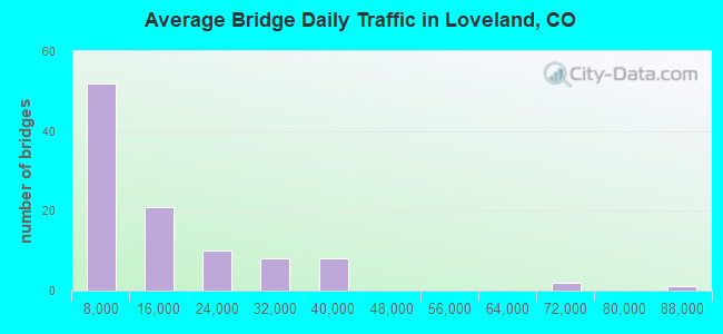
- 1,306,550Total average daily traffic
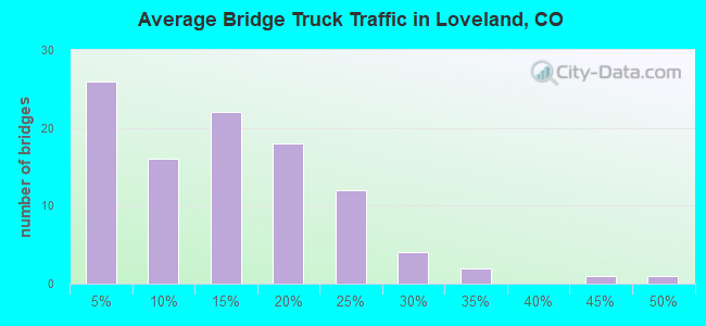
- 124,627Total average daily truck traffic
- National Bridge Inventory (NBI) Registered Bridges for Loveland
- No street view available for this location
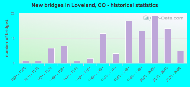
- New bridges - historical statistics
- 11900-1909
- 11910-1919
- 61920-1929
- 71930-1939
- 11940-1949
- 21950-1959
- 121960-1969
- 41970-1979
- 171980-1989
- 131990-1999
- 192000-2009
- 142010-2019
- 52020-2022
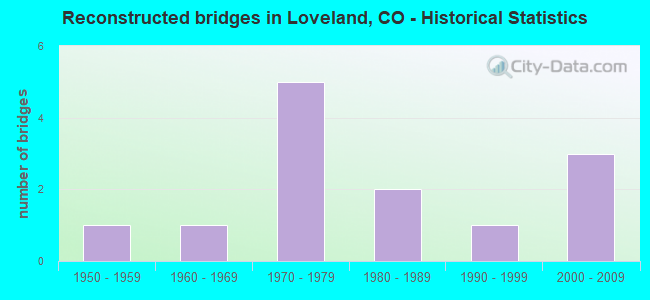
- Reconstructed bridges - Historical Statistics
- 11950-1959
- 11960-1969
- 51970-1979
- 21980-1989
- 11990-1999
- 32000-2009

- Bridge Condition - Deck
- 9.4%Very good
- 50.0%Good
- 29.7%Satisfactory
- 7.8%Fair
- 1.6%Poor
- 1.6%Serious
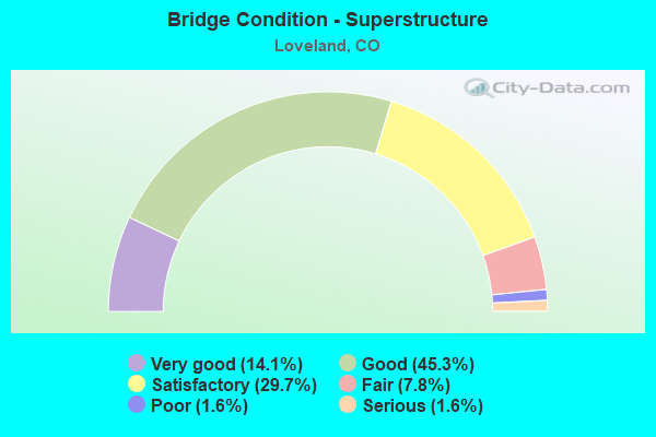
- Bridge Condition - Superstructure
- 14.1%Very good
- 45.3%Good
- 29.7%Satisfactory
- 7.8%Fair
- 1.6%Poor
- 1.6%Serious
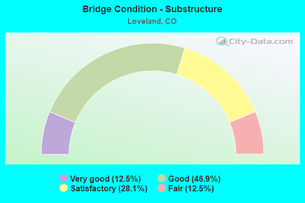
- Bridge Condition - Substructure
- 12.5%Very good
- 46.9%Good
- 28.1%Satisfactory
- 12.5%Fair
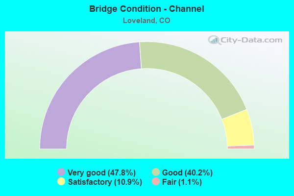
- Bridge Condition - Channel
- 47.8%Very good
- 40.2%Good
- 10.9%Satisfactory
- 1.1%Fair
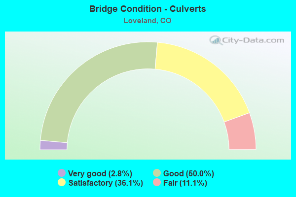
- Bridge Condition - Culverts
- 2.8%Very good
- 50.0%Good
- 36.1%Satisfactory
- 11.1%Fair
Find on map >> Show street view
Structure Number: LR18E-1.8-31, Location: 1.8 Mi E of Co Rd 31 (Lat: 40.384583, Lng: -105.196861), Route carried "on" structure: County highway , Year Built: 1984, Status: Open, Structure Length: 2.07m (6.79ft), Average Daily Traffic: 2,624 (year 2021), Truck Traffic: 26%, Average Future Daily Traffic: 3,280 (year 2041), Design Load: HS 20, Features Intersected: Dry Creek, Facility Carried by Structure: County Road 18E
Minimum Vertical Clearance: 30+ m (98+ ft), Kilometerpoint: 13.053, Lanes on structure: 2, Owner: County Highway Agency, Approaching Roadway Width: 7.3m (24.0ft), Skew: 5 degrees, Material/Design: Concrete, Design/Construction: Culvert, Number Of Spans In Main Unit: 3, Length of Maximum Span: 7.7m (25.3ft), Curb-To-Curb Width: 10.4m (34.1ft), Out-to-Out Width: 11.4m (37.4ft)
Condition: Channel: Good, Culverts: Satisfactory, Operating Rating: 44.9 metric tons, Method Used To Determine Operating Rating: Load Factor (LF), Inventory Rating: 26.9 metric tons, Method Used To Determine Inventory Rating: Load Factor (LF), Structural Evaluation: Equal to present minimum criteria, Deck Geometry: Somewhat better than minimum adequacy, Waterway Adequacy: Better than present minimum criteria, Approach Roadway Alignment: Equal to present desirable criteria, Designated Inspection Frequency: Every 24 months, Inspection Date: May 2021
Find on map >> Show street view
Structure Number: LR19E-0.5-20-A, Location: 0.5 Mi N of W 1st St. (Lat: 40.400464, Lng: -105.123136), Route carried "on" structure: County highway , Year Built: 2019, Status: Open, Structure Length: 4.75m (15.58ft), Average Daily Traffic: 7,717 (year 2021), Truck Traffic: 16%, Average Future Daily Traffic: 9,646 (year 2041), Design Load: HS 25 or greater, Features Intersected: Big Thompson River, Facility Carried by Structure: Namaqua Avenue
Minimum Vertical Clearance: 30+ m (98+ ft), Kilometerpoint: 0.053, Lanes on structure: 2, Owner: County Highway Agency, Approaching Roadway Width: 11.6m (38.1ft), Material/Design: Prestressed concrete continuous, Design/Construction: Box Beam or Girders - Multiple, Number Of Spans In Main Unit: 2, Length of Maximum Span: 22.4m (73.5ft), Curb or Sidewalk Widths: Left: 2.4m (7.9ft), Right: 2.4m (7.9ft), Curb-To-Curb Width: 11.6m (38.1ft), Out-to-Out Width: 17.4m (57.1ft)
Condition: Deck: Good, Superstructure: Very good, Substructure: Good, Channel: Very good, Operating Rating: 59.6 metric tons, Method Used To Determine Operating Rating: Load and Resistance Factor Rating (LRFR) rating reported by rating factor(RF) method using HL-93 loadings, Inventory Rating: 33.7 metric tons, Method Used To Determine Inventory Rating: Load and Resistance Factor Rating (LRFR) rating reported by rating factor(RF) method using HL-93 loadings, Structural Evaluation: Better than present minimum criteria, Deck Geometry: Somewhat better than minimum adequacy, Waterway Adequacy: Equal to present desirable criteria, Approach Roadway Alignment: Equal to present desirable criteria, Designated Inspection Frequency: Every 24 months, Inspection Date: July 2021, Deck Structure Type: Concrete Cast-file-Place, Wearing Surface/Protective System: Wearing Surface: Bituminous, Membrane: Preformed Fabric
Find on map >> Show street view
Structure Number: LR20-0.1-23H-A, Location: 0.1 Mi E of Co Rd 23H (Lat: 40.393028, Lng: -105.165833), Route carried "on" structure: County highway , Year Built: 1986, Status: Open, Structure Length: 2.11m (6.92ft), Average Daily Traffic: 3,328 (year 2021), Truck Traffic: 19%, Average Future Daily Traffic: 4,160 (year 2041), Design Load: HS 20, Features Intersected: Dry Creek, Facility Carried by Structure: County Road 20
Minimum Vertical Clearance: 30+ m (98+ ft), Kilometerpoint: 2.824, Lanes on structure: 2, Owner: County Highway Agency, Approaching Roadway Width: 8.2m (26.9ft), Skew: 3 degrees, Material/Design: Prestressed concrete, Design/Construction: Tee Beam, Number Of Spans In Main Unit: 1, Length of Maximum Span: 19.3m (63.3ft), Curb-To-Curb Width: 11.1m (36.4ft), Out-to-Out Width: 11.9m (39.0ft)
Condition: Deck: Good, Superstructure: Satisfactory, Substructure: Good, Channel: Very good, Operating Rating: 48.3 metric tons, Method Used To Determine Operating Rating: Load Factor (LF), Inventory Rating: 35.8 metric tons, Method Used To Determine Inventory Rating: Load Factor (LF), Structural Evaluation: Equal to present minimum criteria, Deck Geometry: Somewhat better than minimum adequacy, Waterway Adequacy: Better than present minimum criteria, Approach Roadway Alignment: Equal to present desirable criteria, Designated Inspection Frequency: Every 24 months, Inspection Date: May 2021, Deck Structure Type: Concrete Cast-file-Place, Wearing Surface/Protective System: Wearing Surface: Bituminous
Find on map >> Show street view
Structure Number: LR20-0.3-29, Location: 0.3 Mi E of Co Rd 29 (Lat: 40.388278, Lng: -105.187611), Route carried "on" structure: County highway , Year Built: 1982, Status: Open, Structure Length: 1.04m (3.41ft), Average Daily Traffic: 2,523 (year 2021), Truck Traffic: 23%, Average Future Daily Traffic: 3,154 (year 2041), Design Load: HS 20, Features Intersected: Dry Creek, Facility Carried by Structure: County Road 20
Minimum Vertical Clearance: 30+ m (98+ ft), Kilometerpoint: 0.449, Lanes on structure: 2, Owner: County Highway Agency, Approaching Roadway Width: 7.6m (24.9ft), Material/Design: Steel, Design/Construction: Culvert, Number Of Spans In Main Unit: 1, Length of Maximum Span: 10.4m (34.1ft), Out-to-Out Width: 26.3m (86.3ft)
Condition: Channel: Good, Culverts: Satisfactory, Operating Rating: 96.9 metric tons, Method Used To Determine Operating Rating: Load and Resistance Factor Rating (LRFR) rating reported by rating factor(RF) method using HL-93 loadings, Inventory Rating: 96.9 metric tons, Method Used To Determine Inventory Rating: Load and Resistance Factor Rating (LRFR) rating reported by rating factor(RF) method using HL-93 loadings, Structural Evaluation: Equal to present minimum criteria, Waterway Adequacy: Better than present minimum criteria, Approach Roadway Alignment: Equal to present minimum criteria, Designated Inspection Frequency: Every 24 months, Inspection Date: May 2021
Find on map >> Show street view
Structure Number: LR20-0.5-29-A, Location: 0.5 Mi E of Co Rd 29 (Lat: 40.387194, Lng: -105.183861), Route carried "on" structure: County highway , Year Built: 1986, Status: Open, Structure Length: 2.00m (6.56ft), Average Daily Traffic: 2,549 (year 2021), Truck Traffic: 22%, Average Future Daily Traffic: 3,186 (year 2041), Design Load: HS 20, Features Intersected: Dry Creek, Facility Carried by Structure: County Road 20
Minimum Vertical Clearance: 30+ m (98+ ft), Kilometerpoint: 0.824, Lanes on structure: 2, Owner: County Highway Agency, Approaching Roadway Width: 7.6m (24.9ft), Skew: 2 degrees, Material/Design: Prestressed concrete, Design/Construction: Tee Beam, Number Of Spans In Main Unit: 1, Length of Maximum Span: 18.1m (59.4ft), Curb-To-Curb Width: 9.9m (32.5ft), Out-to-Out Width: 10.7m (35.1ft)
Condition: Deck: Good, Superstructure: Good, Substructure: Good, Channel: Good, Operating Rating: 60.8 metric tons, Method Used To Determine Operating Rating: Load Factor (LF), Inventory Rating: 31.2 metric tons, Method Used To Determine Inventory Rating: Load Factor (LF), Structural Evaluation: Better than present minimum criteria, Deck Geometry: Meets minimum limits, Waterway Adequacy: Equal to present desirable criteria, Approach Roadway Alignment: Somewhat better than minimum adequacy, Designated Inspection Frequency: Every 24 months, Inspection Date: May 2021, Deck Structure Type: Other, Wearing Surface/Protective System: Wearing Surface: Bituminous, Membrane: Preformed Fabric, Deck Protection: Epoxy Coated Reinforcing
Find on map >> Show street view
Structure Number: LR23E-0.3-18-A, Location: 0.3 Mi N of Co Rd 18 (Lat: 40.382167, Lng: -105.163417), Route carried "on" structure: County highway , Year Built: 1983, Status: Open, Structure Length: 0.77m (2.53ft), Average Daily Traffic: 1,334 (year 2021), Truck Traffic: 21%, Average Future Daily Traffic: 1,668 (year 2041), Design Load: HS 20, Features Intersected: Handy Ditch, Facility Carried by Structure: County Road 23E
Minimum Vertical Clearance: 30+ m (98+ ft), Kilometerpoint: 0.421, Lanes on structure: 2, Owner: County Highway Agency, Approaching Roadway Width: 7.3m (24.0ft), Skew: 4 degrees, Material/Design: Steel, Design/Construction: Culvert, Number Of Spans In Main Unit: 1, Length of Maximum Span: 7.7m (25.3ft), Out-to-Out Width: 17.1m (56.1ft)
Condition: Channel: Good, Culverts: Fair, Operating Rating: 96.9 metric tons, Method Used To Determine Operating Rating: Load and Resistance Factor Rating (LRFR) rating reported by rating factor(RF) method using HL-93 loadings, Inventory Rating: 81.0 metric tons, Method Used To Determine Inventory Rating: Load and Resistance Factor Rating (LRFR) rating reported by rating factor(RF) method using HL-93 loadings, Structural Evaluation: Somewhat better than minimum adequacy, Waterway Adequacy: Equal to present desirable criteria, Approach Roadway Alignment: Equal to present desirable criteria, Designated Inspection Frequency: Every 24 months, Inspection Date: March 2021
Find on map >> Show street view
Structure Number: LR23E-0.4-18, Location: 0.4 Mi N of Co Rd 18 (Lat: 40.384806, Lng: -105.163389), Route carried "on" structure: County highway , Year Built: 1986, Status: Open, Structure Length: 0.64m (2.10ft), Average Daily Traffic: 1,402 (year 2021), Truck Traffic: 20%, Average Future Daily Traffic: 1,753 (year 2041), Design Load: HS 20, Features Intersected: Home Supply Ditch, Facility Carried by Structure: County Road 23E
Minimum Vertical Clearance: 30+ m (98+ ft), Kilometerpoint: 0.709, Lanes on structure: 2, Owner: County Highway Agency, Approaching Roadway Width: 7.3m (24.0ft), Skew: 1 degrees, Material/Design: Steel, Design/Construction: Culvert, Number Of Spans In Main Unit: 1, Length of Maximum Span: 6.4m (21.0ft), Out-to-Out Width: 20.9m (68.6ft)
Condition: Channel: Good, Culverts: Fair, Operating Rating: 62.2 metric tons, Method Used To Determine Operating Rating: Load Factor (LF), Inventory Rating: 46.6 metric tons, Method Used To Determine Inventory Rating: Load Factor (LF), Structural Evaluation: Somewhat better than minimum adequacy, Waterway Adequacy: Equal to present desirable criteria, Approach Roadway Alignment: Equal to present desirable criteria, Designated Inspection Frequency: Every 24 months, Inspection Date: March 2021
Find on map >> Show street view
Structure Number: LR24-0.8-27, Location: 0.8 Mi E of Co Rd 27 (Lat: 40.422250, Lng: -105.176139), Route carried "on" structure: County highway , Year Built: 1965, Status: Open, Structure Length: 1.91m (6.27ft), Average Daily Traffic: 708 (year 2021), Truck Traffic: 17%, Average Future Daily Traffic: 885 (year 2041), Features Intersected: Buckhorn Creek, Facility Carried by Structure: County Road 24
Minimum Vertical Clearance: 30+ m (98+ ft), Kilometerpoint: 1.259, Lanes on structure: 2, Owner: County Highway Agency, Approaching Roadway Width: 7.3m (24.0ft), Skew: 1 degrees, Material/Design: Prestressed concrete, Design/Construction: Tee Beam, Number Of Spans In Main Unit: 1, Length of Maximum Span: 17.6m (57.7ft), Curb or Sidewalk Widths: Left: 0.2m (0.7ft), Right: 0.2m (0.7ft), Curb-To-Curb Width: 6.9m (22.6ft), Out-to-Out Width: 7.3m (24.0ft)
Condition: Deck: Satisfactory, Superstructure: Satisfactory, Substructure: Satisfactory, Channel: Good, Operating Rating: 36.3 metric tons, Method Used To Determine Operating Rating: Field evaluation and documented engineering judgment, Inventory Rating: 32.7 metric tons, Method Used To Determine Inventory Rating: Field evaluation and documented engineering judgment, Structural Evaluation: Equal to present minimum criteria, Deck Geometry: Meets minimum limits, Waterway Adequacy: Equal to present minimum criteria, Approach Roadway Alignment: Equal to present desirable criteria, Designated Inspection Frequency: Every 24 months, Inspection Date: May 2021, Deck Structure Type: Concrete Cast-file-Place, Wearing Surface/Protective System: Wearing Surface: Bituminous
Find on map >> Show street view
Structure Number: LR24H-0.1-25E-A, Location: 0.1 Mi W of Co Rd 25E (Lat: 40.434250, Lng: -105.180167), Route carried "on" structure: County highway , Year Built: 1996, Status: Open, Structure Length: 1.01m (3.31ft), Average Daily Traffic: 1,877 (year 2021), Truck Traffic: 19%, Average Future Daily Traffic: 2,346 (year 2041), Design Load: HS 20, Features Intersected: Indian Creek, Facility Carried by Structure: County Road 24H
Minimum Vertical Clearance: 30+ m (98+ ft), Kilometerpoint: 1.331, Lanes on structure: 2, Owner: County Highway Agency, Approaching Roadway Width: 9.1m (29.9ft), Skew: 2 degrees, Material/Design: Concrete, Design/Construction: Culvert, Number Of Spans In Main Unit: 2, Length of Maximum Span: 4.9m (16.1ft), Out-to-Out Width: 20.8m (68.2ft)
Condition: Channel: Very good, Culverts: Good, Structural Evaluation: Better than present minimum criteria, Waterway Adequacy: Equal to present desirable criteria, Approach Roadway Alignment: Equal to present desirable criteria, Designated Inspection Frequency: Every 24 months, Inspection Date: May 2021
Find on map >> Show street view
Structure Number: LR24H-0.6-27-A, Location: 0.6 Mi E of Co Rd 27 (Lat: 40.434556, Lng: -105.185028), Route carried "on" structure: County highway , Year Built: 1985, Status: Open, Structure Length: 4.54m (14.90ft), Average Daily Traffic: 434 (year 2021), Truck Traffic: 22%, Average Future Daily Traffic: 543 (year 2041), Design Load: HS 20, Features Intersected: Buckhorn Creek, Facility Carried by Structure: County Road 24H
Minimum Vertical Clearance: 30+ m (98+ ft), Kilometerpoint: 0.892, Lanes on structure: 2, Owner: County Highway Agency, Approaching Roadway Width: 7.6m (24.9ft), Skew: 1 degrees, Material/Design: Prestressed concrete, Design/Construction: Tee Beam, Number Of Spans In Main Unit: 2, Length of Maximum Span: 21.5m (70.5ft), Curb-To-Curb Width: 9.1m (29.9ft), Out-to-Out Width: 9.8m (32.2ft)
Condition: Deck: Good, Superstructure: Satisfactory, Substructure: Good, Channel: Very good, Operating Rating: 56.0 metric tons, Method Used To Determine Operating Rating: Load Factor (LF), Inventory Rating: 33.6 metric tons, Method Used To Determine Inventory Rating: Load Factor (LF), Structural Evaluation: Equal to present minimum criteria, Deck Geometry: Equal to present minimum criteria, Waterway Adequacy: Better than present minimum criteria, Approach Roadway Alignment: Equal to present minimum criteria, Designated Inspection Frequency: Every 24 months, Inspection Date: May 2021, Deck Structure Type: Concrete Cast-file-Place, Wearing Surface/Protective System: Wearing Surface: Bituminous, Membrane: Preformed Fabric, Deck Protection: Epoxy Coated Reinforcing
Find on map >> Show street view
Structure Number: LR25-0.2-24, Location: 0.2 Mi N of Co Rd 24 (Lat: 40.425000, Lng: -105.173972), Route carried "on" structure: County highway , Year Built: 1962, Status: Open, Structure Length: 0.68m (2.23ft), Average Daily Traffic: 2,411 (year 2021), Truck Traffic: 18%, Average Future Daily Traffic: 3,014 (year 2041), Features Intersected: Louden Ditch, Facility Carried by Structure: County Road 25
Minimum Vertical Clearance: 30+ m (98+ ft), Kilometerpoint: 0.292, Lanes on structure: 2, Owner: County Highway Agency, Approaching Roadway Width: 7.3m (24.0ft), Skew: 4 degrees, Material/Design: Concrete, Design/Construction: Culvert, Number Of Spans In Main Unit: 1, Length of Maximum Span: 6.8m (22.3ft), Out-to-Out Width: 14.3m (46.9ft)
Condition: Channel: Very good, Culverts: Satisfactory, Operating Rating: 48.0 metric tons, Method Used To Determine Operating Rating: Load Factor (LF), Inventory Rating: 28.8 metric tons, Method Used To Determine Inventory Rating: Load Factor (LF), Structural Evaluation: Equal to present minimum criteria, Waterway Adequacy: Equal to present desirable criteria, Approach Roadway Alignment: Better than present minimum criteria, Designated Inspection Frequency: Every 24 months, Inspection Date: March 2021
Find on map >> Show street view
Structure Number: LR28-0.5-17, Location: 0.5 Mi E of Co Rd 17 (Lat: 40.451056, Lng: -105.087194), Route carried "on" structure: County highway , Year Built: 1977, Status: Open, Structure Length: 0.81m (2.66ft), Average Daily Traffic: 13,960 (year 2021), Truck Traffic: 17%, Average Future Daily Traffic: 17,450 (year 2041), Design Load: HS 20, Features Intersected: Louden Ditch, Facility Carried by Structure: County Road 28
Minimum Vertical Clearance: 30+ m (98+ ft), Kilometerpoint: 0.055, Lanes on structure: 2, Owner: County Highway Agency, Approaching Roadway Width: 7.3m (24.0ft), Skew: 4 degrees, Material/Design: Prestressed concrete, Design/Construction: Tee Beam, Number Of Spans In Main Unit: 1, Length of Maximum Span: 6.8m (22.3ft), Curb-To-Curb Width: 17.4m (57.1ft), Out-to-Out Width: 18.2m (59.7ft)
Condition: Deck: Satisfactory, Superstructure: Satisfactory, Substructure: Satisfactory, Channel: Good, Operating Rating: 53.3 metric tons, Method Used To Determine Operating Rating: Load Factor (LF), Inventory Rating: 31.9 metric tons, Method Used To Determine Inventory Rating: Load Factor (LF), Structural Evaluation: Equal to present minimum criteria, Deck Geometry: Superior to present desirable criteria, Waterway Adequacy: Equal to present desirable criteria, Approach Roadway Alignment: Equal to present desirable criteria, Designated Inspection Frequency: Every 24 months, Inspection Date: March 2021, Deck Structure Type: Concrete Cast-file-Place, Wearing Surface/Protective System: Wearing Surface: Bituminous
Find on map >> Show street view
Structure Number: LR29-0.0-18E-A, Location: 100 Ft N of Co Rd 18E (Lat: 40.384667, Lng: -105.192278), Route carried "on" structure: County highway , Year Built: 1986, Status: Open, Structure Length: 1.33m (4.36ft), Average Daily Traffic: 3,869 (year 2021), Truck Traffic: 22%, Average Future Daily Traffic: 4,836 (year 2041), Design Load: HS 20, Features Intersected: Dry Creek, Facility Carried by Structure: County Road 29
Minimum Vertical Clearance: 30+ m (98+ ft), Kilometerpoint: 5.090, Lanes on structure: 2, Owner: County Highway Agency, Approaching Roadway Width: 8.2m (26.9ft), Material/Design: Concrete, Design/Construction: Culvert, Number Of Spans In Main Unit: 3, Length of Maximum Span: 4.9m (16.1ft), Out-to-Out Width: 18.3m (60.0ft)
Condition: Channel: Good, Culverts: Good, Operating Rating: 56.9 metric tons, Method Used To Determine Operating Rating: Load Factor (LF), Inventory Rating: 34.1 metric tons, Method Used To Determine Inventory Rating: Load Factor (LF), Structural Evaluation: Better than present minimum criteria, Waterway Adequacy: Equal to present desirable criteria, Approach Roadway Alignment: Equal to present desirable criteria, Designated Inspection Frequency: Every 24 months, Inspection Date: May 2021
Find on map >> Show street view
Structure Number: LR29-0.5-S34-A, Location: 0.5 Mi N of US Hwy 34 (Lat: 40.418889, Lng: -105.204778), Route carried "on" structure: County highway , Year Built: 1981, Status: Open, Structure Length: 0.62m (2.03ft), Average Daily Traffic: 522 (year 2021), Truck Traffic: 21%, Average Future Daily Traffic: 653 (year 2041), Design Load: HS 20+Mod, Features Intersected: Home Supply Ditch, Facility Carried by Structure: County Road 29
Minimum Vertical Clearance: 30+ m (98+ ft), Kilometerpoint: 9.273, Lanes on structure: 2, Owner: County Highway Agency, Approaching Roadway Width: 7.0m (23.0ft), Skew: 2 degrees, Material/Design: Aluminum, Iron, Design/Construction: Culvert, Number Of Spans In Main Unit: 1, Length of Maximum Span: 6.2m (20.3ft), Out-to-Out Width: 16.8m (55.1ft)
Condition: Channel: Good, Culverts: Good, Inventory Rating: 78.2 metric tons, Method Used To Determine Inventory Rating: Load Factor (LF), Structural Evaluation: Better than present minimum criteria, Waterway Adequacy: Better than present minimum criteria, Approach Roadway Alignment: Equal to present minimum criteria, Designated Inspection Frequency: Every 24 months, Inspection Date: March 2021
Find on map >> Show street view
Structure Number: LR29-0.6-20-A, Location: 0.6 Mi N of Co Rd 20 (Lat: 40.397556, Lng: -105.192639), Route carried "on" structure: County highway , Year Built: 2010, Status: Open, Structure Length: 0.61m (2.00ft), Average Daily Traffic: 2,748 (year 2021), Truck Traffic: 21%, Average Future Daily Traffic: 3,435 (year 2041), Design Load: HS 20, Features Intersected: Home Supply Ditch, Facility Carried by Structure: County Road 29
Minimum Vertical Clearance: 30+ m (98+ ft), Kilometerpoint: 6.470, Lanes on structure: 2, Owner: County Highway Agency, Approaching Roadway Width: 8.5m (27.9ft), Material/Design: Concrete, Design/Construction: Culvert, Number Of Spans In Main Unit: 1, Length of Maximum Span: 6.1m (20.0ft), Out-to-Out Width: 17.9m (58.7ft)
Condition: Channel: Satisfactory, Culverts: Good, Operating Rating: 53.2 metric tons, Method Used To Determine Operating Rating: Load Factor (LF), Inventory Rating: 31.8 metric tons, Method Used To Determine Inventory Rating: Load Factor (LF), Structural Evaluation: Better than present minimum criteria, Waterway Adequacy: Equal to present desirable criteria, Approach Roadway Alignment: Equal to present desirable criteria, Designated Inspection Frequency: Every 24 months, Inspection Date: March 2021
Find on map >> Show street view
Structure Number: LR30-0.2-S287, Location: 0.2 Mi E of US Hwy 287 (Lat: 40.465639, Lng: -105.073750), Route carried "on" structure: County highway , Year Built: 1979, Status: Open, Structure Length: 0.61m (2.00ft), Average Daily Traffic: 1,244 (year 2021), Truck Traffic: 28%, Average Future Daily Traffic: 1,555 (year 2041), Design Load: HS 20, Features Intersected: Louden Ditch, Facility Carried by Structure: County Road 30
Minimum Vertical Clearance: 30+ m (98+ ft), Kilometerpoint: 1.144, Lanes on structure: 2, Owner: County Highway Agency, Approaching Roadway Width: 7.3m (24.0ft), Skew: 3 degrees, Material/Design: Aluminum, Iron, Design/Construction: Culvert, Number Of Spans In Main Unit: 1, Length of Maximum Span: 6.1m (20.0ft), Out-to-Out Width: 20.7m (67.9ft)
Condition: Channel: Very good, Culverts: Fair, Operating Rating: 36.3 metric tons, Method Used To Determine Operating Rating: Field evaluation and documented engineering judgment, Inventory Rating: 32.7 metric tons, Method Used To Determine Inventory Rating: Field evaluation and documented engineering judgment, Structural Evaluation: Somewhat better than minimum adequacy, Waterway Adequacy: Equal to present desirable criteria, Approach Roadway Alignment: Equal to present desirable criteria, Designated Inspection Frequency: Every 24 months, Inspection Date: March 2021
Find on map >> Show street view
Structure Number: LRB2-588BTC, Location: 20 Ft S of US Hwy 34 (Lat: 40.417417, Lng: -105.190639), Route carried "on" structure: County highway , Year Built: 1977, Status: Open, Structure Length: 3.04m (9.97ft), Average Daily Traffic: 491 (year 2021), Truck Traffic: 15%, Average Future Daily Traffic: 614 (year 2041), Design Load: H 15, Features Intersected: Big Thompson River, Facility Carried by Structure: River Rim Road
Minimum Vertical Clearance: 30+ m (98+ ft), Kilometerpoint: 136.699, Lanes on structure: 2, Owner: County Highway Agency, Approaching Roadway Width: 6.7m (22.0ft), Material/Design: Prestressed concrete, Design/Construction: Tee Beam, Number Of Spans In Main Unit: 2, Length of Maximum Span: 14.8m (48.6ft), Curb or Sidewalk Widths: Left: 0.2m (0.7ft), Right: 0.2m (0.7ft), Curb-To-Curb Width: 6.9m (22.6ft), Out-to-Out Width: 7.3m (24.0ft)
Condition: Deck: Satisfactory, Superstructure: Fair, Substructure: Satisfactory, Channel: Good, Operating Rating: 32.7 metric tons, Method Used To Determine Operating Rating: Load Factor (LF), Inventory Rating: 17.5 metric tons, Method Used To Determine Inventory Rating: Load Factor (LF), Structural Evaluation: Somewhat better than minimum adequacy, Deck Geometry: Meets minimum limits, Waterway Adequacy: Equal to present desirable criteria, Approach Roadway Alignment: Equal to present minimum criteria, Designated Inspection Frequency: Every 24 months, Inspection Date: April 2021, Deck Structure Type: Other, Wearing Surface/Protective System: Wearing Surface: Monolithic Concrete
Find on map >> Show street view
Structure Number: LRBLUFFLANE1, Location: 0.5 Mi W of S CR 23 (Lat: 40.350733, Lng: -105.163372), Route carried "on" structure: County highway , Year Built: 2016, Status: Open, Structure Length: 1.25m (4.10ft), Average Daily Traffic: 86 (year 2021), Truck Traffic: 30%, Average Future Daily Traffic: 108 (year 2041), Features Intersected: Handy Ditch, Facility Carried by Structure: Bluff Lane
Minimum Vertical Clearance: 30+ m (98+ ft), Kilometerpoint: 0.958, Lanes on structure: 2, Owner: County Highway Agency, Approaching Roadway Width: 7.0m (23.0ft), Material/Design: Concrete, Design/Construction: Tee Beam, Number Of Spans In Main Unit: 1, Length of Maximum Span: 10.5m (34.4ft), Curb-To-Curb Width: 7.0m (23.0ft), Out-to-Out Width: 7.8m (25.6ft)
Condition: Deck: Good, Superstructure: Good, Substructure: Very good, Channel: Very good, Operating Rating: 36.3 metric tons, Method Used To Determine Operating Rating: Field evaluation and documented engineering judgment, Inventory Rating: 32.7 metric tons, Method Used To Determine Inventory Rating: Field evaluation and documented engineering judgment, Structural Evaluation: Better than present minimum criteria, Deck Geometry: Somewhat better than minimum adequacy, Waterway Adequacy: Equal to present desirable criteria, Approach Roadway Alignment: Equal to present desirable criteria, Designated Inspection Frequency: Every 24 months, Inspection Date: April 2021, Deck Structure Type: Other, Wearing Surface/Protective System: Wearing Surface: Bituminous
Find on map >> Show street view
Structure Number: LRBLUFFLANE2, Location: 300 FT W of S CR 23 (Lat: 40.352042, Lng: -105.156058), Route carried "on" structure: County highway , Year Built: 2016, Status: Open, Structure Length: 1.37m (4.49ft), Average Daily Traffic: 175 (year 2021), Truck Traffic: 22%, Average Future Daily Traffic: 219 (year 2041), Features Intersected: Home Supply Ditch, Facility Carried by Structure: Bluff Lane
Minimum Vertical Clearance: 30+ m (98+ ft), Kilometerpoint: 1.639, Lanes on structure: 2, Owner: County Highway Agency, Approaching Roadway Width: 7.0m (23.0ft), Material/Design: Concrete, Design/Construction: Tee Beam, Number Of Spans In Main Unit: 1, Length of Maximum Span: 11.7m (38.4ft), Curb-To-Curb Width: 7.1m (23.3ft), Out-to-Out Width: 7.7m (25.3ft)
Condition: Deck: Good, Superstructure: Good, Substructure: Very good, Channel: Very good, Operating Rating: 36.3 metric tons, Method Used To Determine Operating Rating: Field evaluation and documented engineering judgment, Inventory Rating: 32.7 metric tons, Method Used To Determine Inventory Rating: Field evaluation and documented engineering judgment, Structural Evaluation: Better than present minimum criteria, Deck Geometry: Meets minimum limits, Waterway Adequacy: Equal to present desirable criteria, Approach Roadway Alignment: Equal to present desirable criteria, Designated Inspection Frequency: Every 24 months, Inspection Date: April 2021, Deck Structure Type: Concrete Cast-file-Place, Wearing Surface/Protective System: Wearing Surface: Bituminous
Find on map >> Show street view
Structure Number: LRWILLOWVSTCT1, Location: 0.2 Mi E of W 1st St (Lat: 40.388506, Lng: -105.176197), Route carried "on" structure: County highway , Year Built: 2016, Status: Open, Structure Length: 0.66m (2.17ft), Average Daily Traffic: 187 (year 2021), Truck Traffic: 31%, Average Future Daily Traffic: 234 (year 2041), Features Intersected: Home Supply Creek, Facility Carried by Structure: Willow Vista Court
Minimum Vertical Clearance: 30+ m (98+ ft), Kilometerpoint: 0.269, Lanes on structure: 2, Owner: County Highway Agency, Approaching Roadway Width: 8.9m (29.2ft), Material/Design: Concrete, Design/Construction: Tee Beam, Number Of Spans In Main Unit: 1, Length of Maximum Span: 6.1m (20.0ft), Curb or Sidewalk Widths: Left: 0.4m (1.3ft), Right: 1.4m (4.6ft), Curb-To-Curb Width: 7.2m (23.6ft), Out-to-Out Width: 9.0m (29.5ft)
Condition: Deck: Satisfactory, Superstructure: Satisfactory, Substructure: Satisfactory, Channel: Very good, Operating Rating: 36.3 metric tons, Method Used To Determine Operating Rating: Field evaluation and documented engineering judgment, Inventory Rating: 32.7 metric tons, Method Used To Determine Inventory Rating: Field evaluation and documented engineering judgment, Structural Evaluation: Equal to present minimum criteria, Deck Geometry: Meets minimum limits, Waterway Adequacy: Equal to present desirable criteria, Approach Roadway Alignment: Equal to present desirable criteria, Designated Inspection Frequency: Every 24 months, Inspection Date: April 2021, Deck Structure Type: Concrete Cast-file-Place, Wearing Surface/Protective System: Wearing Surface: Monolithic Concrete
Find on map >> Show street view
Structure Number: LRWLLWSBNDDR1, Location: 0.4 Mi S of W CR 20 (Lat: 40.384881, Lng: -105.177564), Route carried "on" structure: County highway , Year Built: 2016, Status: Open, Structure Length: 0.97m (3.18ft), Average Daily Traffic: 88 (year 2021), Truck Traffic: 45%, Average Future Daily Traffic: 110 (year 2041), Features Intersected: Handy Ditch, Facility Carried by Structure: 14th Street SW
Minimum Vertical Clearance: 30+ m (98+ ft), Kilometerpoint: 0.423, Lanes on structure: 2, Owner: County Highway Agency, Approaching Roadway Width: 7.5m (24.6ft), Skew: 4 degrees, Material/Design: Concrete, Design/Construction: Culvert, Number Of Spans In Main Unit: 1, Length of Maximum Span: 9.1m (29.9ft), Curb-To-Curb Width: 11.7m (38.4ft), Out-to-Out Width: 12.3m (40.4ft)
Condition: Channel: Very good, Culverts: Good, Operating Rating: 36.3 metric tons, Method Used To Determine Operating Rating: Field evaluation and documented engineering judgment, Inventory Rating: 32.7 metric tons, Method Used To Determine Inventory Rating: Field evaluation and documented engineering judgment, Structural Evaluation: Better than present minimum criteria, Deck Geometry: Superior to present desirable criteria, Waterway Adequacy: Equal to present desirable criteria, Approach Roadway Alignment: Equal to present desirable criteria, Designated Inspection Frequency: Every 24 months, Inspection Date: April 2021, Deck Structure Type: Concrete Cast-file-Place, Wearing Surface/Protective System: Wearing Surface: Bituminous
Find on map >> Show street view
Structure Number: C-17-EG, Location: I-25 LOVELAND INTERCH. (Lat: 40.407175, Lng: -104.993575), Route carried "under" structure: Interstate 25A, Year Built: 1962, Structure Length: 0. m, Average Daily Traffic: 68,000 (year 2011), Truck Traffic: 11%, Features Intersected: I 25 ML, Facility Carried by Structure: US 34 ML WBND
Minimum Vertical Clearance: 5.87m (19.26ft), Kilometerpoint: 414.005, Lanes on structure: 3, Lanes under structure: 6, Material/Design: Concrete continuous, Design/Construction: Tee Beam, Length of Maximum Span: 22.3m (73.2ft)
Find on map >> Show street view
Structure Number: C-17-EH, Location: LOVELAND INTERCHANGE (Lat: 40.406978, Lng: -104.993567), Route carried "under" structure: Interstate 25A, Year Built: 1962, Structure Length: 0. m, Average Daily Traffic: 68,000 (year 2011), Truck Traffic: 11%, Features Intersected: I 25 ML, Facility Carried by Structure: US 34 ML EBND
Minimum Vertical Clearance: 6.30m (20.67ft), Kilometerpoint: 414.004, Lanes on structure: 3, Lanes under structure: 6, Material/Design: Concrete continuous, Design/Construction: Tee Beam, Length of Maximum Span: 22.3m (73.2ft)