Bridge Statistics for Lumberton, North Carolina (NC)
Condition, Traffic, Stress, Structural Evaluation, Project Costs
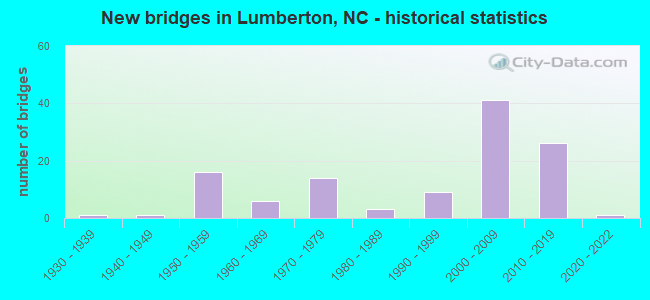
- New bridges - historical statistics
- 11930-1939
- 11940-1949
- 161950-1959
- 61960-1969
- 141970-1979
- 31980-1989
- 91990-1999
- 412000-2009
- 262010-2019
- 12020-2022


- Bridge Condition - Deck
- 26.2%Very good
- 35.4%Good
- 23.1%Satisfactory
- 13.8%Fair
- 1.5%Poor

- Bridge Condition - Superstructure
- 35.4%Very good
- 40.0%Good
- 16.9%Satisfactory
- 7.7%Fair

- Bridge Condition - Substructure
- 23.1%Very good
- 35.4%Good
- 26.2%Satisfactory
- 13.8%Fair
- 1.5%Poor

- Bridge Condition - Channel
- 20.0%Very good
- 58.3%Good
- 5.0%Satisfactory
- 16.7%Fair

- Bridge Condition - Culverts
- 33.3%Very good
- 13.3%Good
- 33.3%Satisfactory
- 13.3%Fair
- 6.7%Poor
Find on map >> Show street view
Structure Number: 1550055, Location: 0.1 MI E JCT US301 (Lat: 34.600914, Lng: -79.103308), Route carried "under" structure: Ramp Interstate 95, Year Built: 2008, Structure Length: 0. m, Average Daily Traffic: 10,750 (year 2019), Truck Traffic: 23%, Features Intersected: US74
Minimum Vertical Clearance: 5.81m (19.06ft), Kilometerpoint: 4.145, Lanes on structure: 2, Lanes under structure: 3, Material/Design: Steel continuous, Design/Construction: Stringer/Multi-beam, Length of Maximum Span: 46.6m (152.9ft)
Find on map >> Show street view
Structure Number: 1550055, Location: 0.1 MI E JCT US301 (Lat: 34.600914, Lng: -79.103308), Route carried "under" structure: Interstate 95, Year Built: 2008, Structure Length: 0. m, Average Daily Traffic: 21,500 (year 2019), Truck Traffic: 16%, Features Intersected: US74
Minimum Vertical Clearance: 5.25m (17.22ft), Kilometerpoint: 4.145, Lanes on structure: 2, Lanes under structure: 2, Material/Design: Steel continuous, Design/Construction: Stringer/Multi-beam, Length of Maximum Span: 46.6m (152.9ft)
Find on map >> Show street view
Structure Number: 155007, Location: 1.1 MI.E.JCT.SR2420 (Lat: 34.579647, Lng: -79.048342), Route carried "under" structure: State highway 41, Year Built: 1971, Structure Length: 0. m, Average Daily Traffic: 9,250 (year 2018), Truck Traffic: 6%, Features Intersected: US74E
Minimum Vertical Clearance: 4.77m (15.65ft), Kilometerpoint: 0.000, Lanes on structure: 2, Lanes under structure: 3, Material/Design: Steel, Design/Construction: Stringer/Multi-beam, Length of Maximum Span: 25.2m (82.7ft)
Find on map >> Show street view
Structure Number: 1550072, Location: 1.1 MI.E.JCT.SR2420 (Lat: 34.579886, Lng: -79.048194), Route carried "under" structure: State highway 41, Year Built: 1969, Structure Length: 0. m, Average Daily Traffic: 11,000 (year 2017), Truck Traffic: 6%, Features Intersected: US74W
Minimum Vertical Clearance: 4.85m (15.91ft), Kilometerpoint: 64.923, Lanes on structure: 2, Lanes under structure: 3, Material/Design: Steel, Design/Construction: Stringer/Multi-beam, Length of Maximum Span: 25.2m (82.7ft)
Find on map >> Show street view
Structure Number: 1550102, Location: 1.6 MI.W. JCT. NC41 (Lat: 34.646456, Lng: -79.013436), Route carried "under" structure: Interstate 95, Year Built: 2001, Structure Length: 0. m, Average Daily Traffic: 31,000 (year 2017), Truck Traffic: 16%, Features Intersected: NC211
Minimum Vertical Clearance: 5.58m (18.31ft), Kilometerpoint: 6.065, Lanes on structure: 6, Lanes under structure: 3, Material/Design: Prestressed concrete, Design/Construction: Stringer/Multi-beam, Length of Maximum Span: 29.5m (96.8ft)
Find on map >> Show street view
Structure Number: 1550102, Location: 1.6 MI.W. JCT. NC41 (Lat: 34.646456, Lng: -79.013436), Route carried "under" structure: Interstate 95, Year Built: 2001, Structure Length: 0. m, Average Daily Traffic: 31,000 (year 2017), Truck Traffic: 16%, Features Intersected: NC211
Minimum Vertical Clearance: 6.29m (20.64ft), Kilometerpoint: 6.065, Lanes on structure: 6, Lanes under structure: 3, Material/Design: Prestressed concrete, Design/Construction: Stringer/Multi-beam, Length of Maximum Span: 29.5m (96.8ft)
Find on map >> Show street view
Structure Number: 1550131, Location: 0.2MI E. JCT. US301 (Lat: 34.586764, Lng: -79.125169), Route carried "under" structure: Interstate 95, Year Built: 1972, Structure Length: 0. m, Average Daily Traffic: 22,250 (year 2018), Truck Traffic: 23%, Features Intersected: SR2422
Minimum Vertical Clearance: 5.30m (17.39ft), Kilometerpoint: 0.000, Lanes on structure: 2, Lanes under structure: 3, Material/Design: Steel continuous, Design/Construction: Stringer/Multi-beam, Length of Maximum Span: 41.7m (136.8ft)
Find on map >> Show street view
Structure Number: 1550131, Location: 0.2MI E. JCT. US301 (Lat: 34.586764, Lng: -79.125169), Route carried "under" structure: Interstate 95, Year Built: 1972, Structure Length: 0. m, Average Daily Traffic: 22,250 (year 2018), Truck Traffic: 23%, Features Intersected: SR2422
Minimum Vertical Clearance: 5.24m (17.19ft), Kilometerpoint: 3.688, Lanes on structure: 2, Lanes under structure: 3, Material/Design: Steel continuous, Design/Construction: Stringer/Multi-beam, Length of Maximum Span: 41.7m (136.8ft)
Find on map >> Show street view
Structure Number: 1550144, Location: 0.8 MI N JCT NC72 (Lat: 34.627572, Lng: -79.039733), Route carried "under" structure: City street , Year Built: 1955, Structure Length: 0. m, Average Daily Traffic: 300 (year 1990), Truck Traffic: 7%, Features Intersected: I95N, US301N, Facility Carried by Structure: SR1541,VFW RD.
Minimum Vertical Clearance: 6.40m (21.00ft), Kilometerpoint: 5.425, Lanes on structure: 2, Lanes under structure: 2, Material/Design: Steel, Design/Construction: Stringer/Multi-beam, Length of Maximum Span: 17.0m (55.8ft)
Find on map >> Show street view
Structure Number: 1550145, Location: 0.8 MI N JCT NC72 (Lat: 34.627650, Lng: -79.039950), Route carried "under" structure: State highway 1541, Year Built: 1955, Structure Length: 0. m, Average Daily Traffic: 300 (year 1990), Truck Traffic: 7%, Features Intersected: I95S,US301S
Minimum Vertical Clearance: 6.50m (21.33ft), Kilometerpoint: 0.000, Lanes on structure: 2, Lanes under structure: 2, Material/Design: Steel, Design/Construction: Stringer/Multi-beam, Length of Maximum Span: 17.0m (55.8ft)
Find on map >> Show street view
Structure Number: 1550148, Location: 0.12 MI. E. JCT. SR1586 (Lat: 34.634172, Lng: -79.025375), Route carried "under" structure: Interstate 95, Year Built: 1955, Structure Length: 0. m, Average Daily Traffic: 31,500 (year 2017), Truck Traffic: 16%, Features Intersected: SR1536
Minimum Vertical Clearance: 5.00m (16.40ft), Kilometerpoint: 5.730, Lanes on structure: 2, Lanes under structure: 2, Material/Design: Steel, Design/Construction: Stringer/Multi-beam, Length of Maximum Span: 19.5m (64.0ft)
Find on map >> Show street view
Structure Number: 1550148, Location: 0.12 MI. E. JCT. SR1586 (Lat: 34.634172, Lng: -79.025375), Route carried "under" structure: Interstate 95, Year Built: 1955, Structure Length: 0. m, Average Daily Traffic: 31,500 (year 2017), Truck Traffic: 16%, Features Intersected: SR1536
Minimum Vertical Clearance: 5.13m (16.83ft), Kilometerpoint: 5.730, Lanes on structure: 2, Lanes under structure: 2, Material/Design: Steel, Design/Construction: Stringer/Multi-beam, Length of Maximum Span: 19.5m (64.0ft)
Find on map >> Show street view
Structure Number: 1550484, Location: 1.3 MI. S. JCT. US74 ALT. (Lat: 34.597786, Lng: -79.133586), Route carried "under" structure: Interstate 74, Year Built: 2008, Structure Length: 0. m, Average Daily Traffic: 8,000 (year 2019), Truck Traffic: 23%, Features Intersected: SR1164
Minimum Vertical Clearance: 5.38m (17.65ft), Kilometerpoint: 63.368, Lanes on structure: 3, Lanes under structure: 2, Material/Design: Steel continuous, Design/Construction: Stringer/Multi-beam, Length of Maximum Span: 30.1m (98.8ft)
Find on map >> Show street view
Structure Number: 1550484, Location: 1.3 MI. S. JCT. US74 ALT. (Lat: 34.597786, Lng: -79.133586), Route carried "under" structure: Interstate 74, Year Built: 2008, Structure Length: 0. m, Average Daily Traffic: 8,000 (year 2019), Truck Traffic: 23%, Features Intersected: SR1164
Minimum Vertical Clearance: 5.46m (17.91ft), Kilometerpoint: 63.368, Lanes on structure: 3, Lanes under structure: 2, Material/Design: Steel continuous, Design/Construction: Stringer/Multi-beam, Length of Maximum Span: 30.1m (98.8ft)
Find on map >> Show street view
Structure Number: 1550485, Location: 0.5 MI NORTH OF SR1164 (Lat: 34.594306, Lng: -79.118425), Route carried "under" structure: US 74, Year Built: 2008, Structure Length: 0. m, Average Daily Traffic: 7,500 (year 2018), Truck Traffic: 14%, Features Intersected: SR1207
Minimum Vertical Clearance: 5.42m (17.78ft), Kilometerpoint: 63.643, Lanes on structure: 2, Lanes under structure: 4, Material/Design: Steel continuous, Design/Construction: Stringer/Multi-beam, Length of Maximum Span: 42.0m (137.8ft)
Find on map >> Show street view
Structure Number: 1550485, Location: 0.5 MI NORTH OF SR1164 (Lat: 34.594306, Lng: -79.118425), Route carried "under" structure: US 74, Year Built: 2008, Structure Length: 0. m, Average Daily Traffic: 7,500 (year 2018), Truck Traffic: 14%, Features Intersected: SR1207
Minimum Vertical Clearance: 5.24m (17.19ft), Kilometerpoint: 63.643, Lanes on structure: 2, Lanes under structure: 3, Material/Design: Steel continuous, Design/Construction: Stringer/Multi-beam, Length of Maximum Span: 42.0m (137.8ft)
Find on map >> Show street view
Structure Number: 1550486, Location: 0.7 MI. W. JCT. US74 BUS. (Lat: 34.593378, Lng: -79.110858), Route carried "under" structure: Ramp Interstate 95, Year Built: 2009, Structure Length: 0. m, Average Daily Traffic: 10,750 (year 2019), Truck Traffic: 23%, Features Intersected: I74,US74
Minimum Vertical Clearance: 5.69m (18.67ft), Kilometerpoint: 0.000, Lanes on structure: 4, Lanes under structure: 2, Material/Design: Steel continuous, Design/Construction: Stringer/Multi-beam, Length of Maximum Span: 32.3m (106.0ft)
Find on map >> Show street view
Structure Number: 1550486, Location: 0.7 MI. W. JCT. US74 BUS. (Lat: 34.593378, Lng: -79.110858), Route carried "under" structure: Interstate 95, Year Built: 2009, Structure Length: 0. m, Average Daily Traffic: 10,750 (year 2019), Truck Traffic: 23%, Features Intersected: I74,US74
Minimum Vertical Clearance: 5.89m (19.32ft), Kilometerpoint: 3.931, Lanes on structure: 4, Lanes under structure: 2, Material/Design: Steel continuous, Design/Construction: Stringer/Multi-beam, Length of Maximum Span: 32.3m (106.0ft)
Find on map >> Show street view
Structure Number: 1550486, Location: 0.7 MI. W. JCT. US74 BUS. (Lat: 34.593378, Lng: -79.110858), Route carried "under" structure: Interstate 95, Year Built: 2009, Structure Length: 0. m, Average Daily Traffic: 10,750 (year 2019), Truck Traffic: 23%, Features Intersected: I74,US74
Minimum Vertical Clearance: 5.96m (19.55ft), Kilometerpoint: 3.931, Lanes on structure: 4, Lanes under structure: 2, Material/Design: Steel continuous, Design/Construction: Stringer/Multi-beam, Length of Maximum Span: 32.3m (106.0ft)
Find on map >> Show street view
Structure Number: 1550486, Location: 0.7 MI. W. JCT. US74 BUS. (Lat: 34.593378, Lng: -79.110858), Route carried "under" structure: Ramp Interstate 95, Year Built: 2009, Structure Length: 0. m, Average Daily Traffic: 10,750 (year 2019), Truck Traffic: 23%, Features Intersected: I74,US74
Minimum Vertical Clearance: 6.07m (19.91ft), Kilometerpoint: 3.931, Lanes on structure: 4, Lanes under structure: 2, Material/Design: Steel continuous, Design/Construction: Stringer/Multi-beam, Length of Maximum Span: 32.3m (106.0ft)
Find on map >> Show street view
Structure Number: 1550487, Location: 0.3 MI. E. JCT. SR1207 (Lat: 34.593125, Lng: -79.111189), Route carried "under" structure: Ramp Interstate 95, Year Built: 2008, Structure Length: 0. m, Average Daily Traffic: 10,750 (year 2019), Truck Traffic: 23%, Features Intersected: I74E
Minimum Vertical Clearance: 6.04m (19.82ft), Kilometerpoint: 3.931, Lanes on structure: 4, Lanes under structure: 2, Material/Design: Steel continuous, Design/Construction: Stringer/Multi-beam, Length of Maximum Span: 33.2m (108.9ft)
Find on map >> Show street view
Structure Number: 1550487, Location: 0.3 MI. E. JCT. SR1207 (Lat: 34.593125, Lng: -79.111189), Route carried "under" structure: Interstate 95, Year Built: 2008, Structure Length: 0. m, Average Daily Traffic: 21,500 (year 2019), Truck Traffic: 23%, Features Intersected: I74E
Minimum Vertical Clearance: 5.81m (19.06ft), Kilometerpoint: 3.931, Lanes on structure: 4, Lanes under structure: 2, Material/Design: Steel continuous, Design/Construction: Stringer/Multi-beam, Length of Maximum Span: 33.2m (108.9ft)
Find on map >> Show street view
Structure Number: 1550487, Location: 0.3 MI. E. JCT. SR1207 (Lat: 34.593125, Lng: -79.111189), Route carried "under" structure: Ramp Interstate 95, Year Built: 2008, Structure Length: 0. m, Average Daily Traffic: 10,750 (year 2019), Truck Traffic: 23%, Features Intersected: I74E
Minimum Vertical Clearance: 5.38m (17.65ft), Kilometerpoint: 3.931, Lanes on structure: 4, Lanes under structure: 2, Material/Design: Steel continuous, Design/Construction: Stringer/Multi-beam, Length of Maximum Span: 33.2m (108.9ft)
Find on map >> Show street view
Structure Number: 1550487, Location: 0.3 MI. E. JCT. SR1207 (Lat: 34.593125, Lng: -79.111189), Route carried "under" structure: Interstate 95, Year Built: 2008, Structure Length: 0. m, Average Daily Traffic: 21,500 (year 2019), Truck Traffic: 23%, Features Intersected: I74E
Minimum Vertical Clearance: 5.58m (18.31ft), Kilometerpoint: 3.931, Lanes on structure: 4, Lanes under structure: 2, Material/Design: Steel continuous, Design/Construction: Stringer/Multi-beam, Length of Maximum Span: 33.2m (108.9ft)
Find on map >> Show street view
Structure Number: 1550488, Location: 0.1 MI. N. JCT. SR2317 (Lat: 34.592842, Lng: -79.088808), Route carried "under" structure: Interstate 74, Year Built: 2008, Structure Length: 0. m, Average Daily Traffic: 7,750 (year 2019), Truck Traffic: 23%, Features Intersected: SR2418
Minimum Vertical Clearance: 5.33m (17.49ft), Kilometerpoint: 64.191, Lanes on structure: 2, Lanes under structure: 2, Material/Design: Steel continuous, Design/Construction: Stringer/Multi-beam, Length of Maximum Span: 30.4m (99.7ft)
Find on map >> Show street view
Structure Number: 1550488, Location: 0.1 MI. N. JCT. SR2317 (Lat: 34.592842, Lng: -79.088808), Route carried "under" structure: Interstate 74, Year Built: 2008, Structure Length: 0. m, Average Daily Traffic: 7,750 (year 2019), Truck Traffic: 23%, Features Intersected: SR2418
Minimum Vertical Clearance: 5.38m (17.65ft), Kilometerpoint: 64.191, Lanes on structure: 2, Lanes under structure: 2, Material/Design: Steel continuous, Design/Construction: Stringer/Multi-beam, Length of Maximum Span: 30.4m (99.7ft)
Find on map >> Show street view
Structure Number: 1550489, Location: 0.5 MI. N. JCT. SR2418 (Lat: 34.589992, Lng: -79.068683), Route carried "under" structure: Interstate 74, Year Built: 2009, Structure Length: 0. m, Average Daily Traffic: 7,500 (year 2019), Truck Traffic: 23%, Features Intersected: SR2505
Minimum Vertical Clearance: 5.76m (18.90ft), Kilometerpoint: 64.526, Lanes on structure: 4, Lanes under structure: 2, Material/Design: Steel continuous, Design/Construction: Stringer/Multi-beam, Length of Maximum Span: 32.0m (105.0ft)
Find on map >> Show street view
Structure Number: 1550489, Location: 0.5 MI. N. JCT. SR2418 (Lat: 34.589992, Lng: -79.068683), Route carried "under" structure: Interstate 74, Year Built: 2009, Structure Length: 0. m, Average Daily Traffic: 7,500 (year 2019), Truck Traffic: 23%, Features Intersected: SR2505
Minimum Vertical Clearance: 5.63m (18.47ft), Kilometerpoint: 64.526, Lanes on structure: 4, Lanes under structure: 2, Material/Design: Steel continuous, Design/Construction: Stringer/Multi-beam, Length of Maximum Span: 32.0m (105.0ft)
Find on map >> Show street view
Structure Number: 155049, Location: 0.4 MI.S.JCT.SR2310 (Lat: 34.544569, Lng: -79.021581), Route carried "under" structure: US 74, Year Built: 2009, Structure Length: 0. m, Average Daily Traffic: 5,500 (year 2015), Truck Traffic: 14%, Features Intersected: SR2210
Minimum Vertical Clearance: 5.25m (17.22ft), Kilometerpoint: 65.898, Lanes on structure: 2, Lanes under structure: 2, Material/Design: Prestressed concrete continuous, Design/Construction: Stringer/Multi-beam, Length of Maximum Span: 28.9m (94.8ft)
Find on map >> Show street view
Structure Number: 155049, Location: 0.4 MI.S.JCT.SR2310 (Lat: 34.544569, Lng: -79.021581), Route carried "under" structure: US 74, Year Built: 2009, Structure Length: 0. m, Average Daily Traffic: 5,500 (year 2015), Truck Traffic: 14%, Features Intersected: SR2210
Minimum Vertical Clearance: 5.21m (17.09ft), Kilometerpoint: 65.898, Lanes on structure: 2, Lanes under structure: 2, Material/Design: Prestressed concrete continuous, Design/Construction: Stringer/Multi-beam, Length of Maximum Span: 28.9m (94.8ft)
Find on map >> Show street view
Structure Number: 155051, Location: 0.5 MI. N. JCT. SR1005 (Lat: 34.670083, Lng: -79.006028), Route carried "under" structure: Interstate 95, Year Built: 2014, Structure Length: 0. m, Average Daily Traffic: 29,500 (year 2018), Truck Traffic: 16%, Features Intersected: US301N
Minimum Vertical Clearance: 5.66m (18.57ft), Kilometerpoint: 6.583, Lanes on structure: 2, Lanes under structure: 2, Material/Design: Prestressed concrete continuous, Design/Construction: Stringer/Multi-beam, Length of Maximum Span: 31.3m (102.7ft)
Find on map >> Show street view
Structure Number: 155051, Location: 0.5 MI. N. JCT. SR1005 (Lat: 34.670083, Lng: -79.006028), Route carried "under" structure: Interstate 95, Year Built: 2014, Structure Length: 0. m, Average Daily Traffic: 29,500 (year 2018), Truck Traffic: 16%, Features Intersected: US301N
Minimum Vertical Clearance: 5.43m (17.81ft), Kilometerpoint: 6.583, Lanes on structure: 2, Lanes under structure: 2, Material/Design: Prestressed concrete continuous, Design/Construction: Stringer/Multi-beam, Length of Maximum Span: 31.3m (102.7ft)