Bridge Statistics for Madison, Mississippi (MS)
Condition, Traffic, Stress, Structural Evaluation, Project Costs
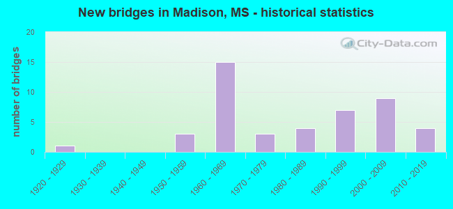
- New bridges - historical statistics
- 11920-1929
- 31950-1959
- 151960-1969
- 31970-1979
- 41980-1989
- 71990-1999
- 92000-2009
- 42010-2019

- Reconstructed bridges - Historical Statistics
- 11980-1989
- 01990-1999
- 22000-2009


- Bridge Condition - Deck
- 6.7%Very good
- 56.7%Good
- 26.7%Satisfactory
- 10.0%Fair

- Bridge Condition - Superstructure
- 23.3%Very good
- 43.3%Good
- 20.0%Satisfactory
- 13.3%Fair

- Bridge Condition - Substructure
- 20.0%Very good
- 60.0%Good
- 6.7%Satisfactory
- 10.0%Fair
- 3.3%Poor

- Bridge Condition - Channel
- 35.1%Very good
- 35.1%Good
- 24.3%Satisfactory
- 5.4%Fair

- Bridge Condition - Culverts
- 21.4%Very good
- 35.7%Good
- 42.9%Satisfactory
Find on map >> Show street view
Structure Number: SA4500000000192, Location: SEC 20 T 7N R 2E (Lat: 32.439278, Lng: -90.112361), Route carried "on" structure: City street 8421, Year Built: 2008, Status: Posted for load, Structure Length: 12.89m (42.29ft), Average Daily Traffic: 300 (year 2016), Truck Traffic: 8%, Average Future Daily Traffic: 450 (year 2036), Design Load: H 15, Features Intersected: BRASHEAR CREEK, Facility Carried by Structure: MCCLELLAN DR
Minimum Vertical Clearance: 30+ m (98+ ft), Kilometerpoint: 0.965, Lanes on structure: 2, Owner: City or Municipal Highway Agency, Approaching Roadway Width: 8.6m (28.2ft), Material/Design: Concrete, Design/Construction: Channel Beam, Number Of Spans In Main Unit: 21, Length of Maximum Span: 9.4m (30.8ft), Curb or Sidewalk Widths: Left: 0.4m (1.3ft), Right: 0.4m (1.3ft), Curb-To-Curb Width: 8.6m (28.2ft), Out-to-Out Width: 9.4m (30.8ft)
Condition: Deck: Fair, Superstructure: Fair, Substructure: Good, Channel: Good, Operating Rating: 32.7 metric tons, Method Used To Determine Operating Rating: Allowable Stress (AS), Inventory Rating: 19.6 metric tons, Method Used To Determine Inventory Rating: Allowable Stress (AS), Structural Evaluation: Somewhat better than minimum adequacy, Deck Geometry: Equal to present minimum criteria, Waterway Adequacy: Better than present minimum criteria, Approach Roadway Alignment: Equal to present minimum criteria, Bridge Posting: Required (Relationship of Operating Rating to Maximum Legal Load: 10.0 - 19.9% below), Length Of Structure Improvement: 0.05m (0.16ft), Designated Inspection Frequency: Every 24 months, Inspection Date: October 2019, Bridge Improvement Cost: $30,000, Roadway Improvement Cost: $2,000, Total Project Cost: $32,000 ( Estimate for 2020), Deck Structure Type: Concrete Precast Panels, Wearing Surface/Protective System: Wearing Surface: Monolithic Concrete
Find on map >> Show street view
Structure Number: SA4500000000193, Location: SEC 21 T 7N R 2E (Lat: 32.442833, Lng: -90.081944), Route carried "on" structure: City street 8214, Year Built: 1998, Status: Open, Structure Length: 0.94m (3.08ft), Average Daily Traffic: 120 (year 2016), Truck Traffic: 8%, Average Future Daily Traffic: 180 (year 2036), Design Load: HS 20, Features Intersected: BCH OF CULLEY CK, Facility Carried by Structure: CHEYENNE LN
Minimum Vertical Clearance: 30+ m (98+ ft), Kilometerpoint: 2.253, Lanes on structure: 2, Owner: City or Municipal Highway Agency, Approaching Roadway Width: 6.7m (22.0ft), Material/Design: Concrete, Design/Construction: Channel Beam, Number Of Spans In Main Unit: 1, Length of Maximum Span: 9.4m (30.8ft), Curb or Sidewalk Widths: Left: 0.2m (0.7ft), Right: 0.2m (0.7ft), Curb-To-Curb Width: 7.1m (23.3ft), Out-to-Out Width: 7.5m (24.6ft)
Condition: Deck: Good, Superstructure: Good, Substructure: Very good, Channel: Very good, Operating Rating: 67.1 metric tons, Method Used To Determine Operating Rating: Load Factor (LF) rating reported by rating factor (RF) method using MS18 loading, Inventory Rating: 40.2 metric tons, Method Used To Determine Inventory Rating: Load Factor (LF) rating reported by rating factor (RF) method using MS18 loading, Structural Evaluation: Better than present minimum criteria, Deck Geometry: Meets minimum limits, Waterway Adequacy: Equal to present desirable criteria, Approach Roadway Alignment: Equal to present desirable criteria, Designated Inspection Frequency: Every 24 months, Inspection Date: May 2020, Deck Structure Type: Concrete Precast Panels
Find on map >> Show street view
Structure Number: SA450000000A018, Location: SEC 29 T 8N R 1E (Lat: 32.507333, Lng: -90.217889), Route carried "on" structure: County highway 246, Year Built: 2014, Status: Open, Structure Length: 0.85m (2.79ft), Average Daily Traffic: 50 (year 2015), Average Future Daily Traffic: 75 (year 2035), Design Load: HS 20, Features Intersected: CREEK, Facility Carried by Structure: GUS GREEN ROAD
Minimum Vertical Clearance: 30+ m (98+ ft), Kilometerpoint: 1.609, Lanes on structure: 2, Owner: County Highway Agency, Approaching Roadway Width: 8.1m (26.6ft), Material/Design: Concrete, Design/Construction: Culvert, Number Of Spans In Main Unit: 2, Length of Maximum Span: 4.3m (14.1ft)
Condition: Channel: Good, Culverts: Very good, Operating Rating: 72.6 metric tons, Method Used To Determine Operating Rating: Load Factor (LF) rating reported by rating factor (RF) method using MS18 loading, Inventory Rating: 40.2 metric tons, Method Used To Determine Inventory Rating: Load Factor (LF) rating reported by rating factor (RF) method using MS18 loading, Structural Evaluation: Equal to present desirable criteria, Waterway Adequacy: Equal to present desirable criteria, Approach Roadway Alignment: Equal to present desirable criteria, Designated Inspection Frequency: Every 24 months, Inspection Date: Febuary 2021
Find on map >> Show street view
Structure Number: 31004630450015, Location: SR 463 OVER I 55 (Lat: 32.470519, Lng: -90.134581), Route carried "under" structure: Interstate 55, Year Built: 2001, Structure Length: 0. m, Average Daily Traffic: 37,500 (year 2017), Truck Traffic: 5%, Features Intersected: I 55, Facility Carried by Structure: SR 463
Minimum Vertical Clearance: 5.84m (19.16ft), Kilometerpoint: 31.509, Lanes on structure: 4, Lanes under structure: 4, Material/Design: Steel continuous, Design/Construction: Box Beam or Girders - Multiple, Length of Maximum Span: 29.9m (98.1ft)
Find on map >> Show street view
Structure Number: 31004630450015, Location: SR 463 OVER I 55 (Lat: 32.470419, Lng: -90.134339), Route carried "under" structure: Interstate 55, Year Built: 2001, Structure Length: 0. m, Average Daily Traffic: 37,500 (year 2017), Truck Traffic: 5%, Features Intersected: I 55, Facility Carried by Structure: SR 463
Minimum Vertical Clearance: 5.81m (19.06ft), Kilometerpoint: 8.174, Lanes on structure: 4, Lanes under structure: 4, Material/Design: Steel continuous, Design/Construction: Box Beam or Girders - Multiple, Length of Maximum Span: 29.9m (98.1ft)