Bridge Statistics for Madison, Nebraska (NE)
Condition, Traffic, Stress, Structural Evaluation, Project Costs
- National Bridge Inventory (NBI) Statistics
- 45Number of bridges
- 285ft / 87.5mTotal length
- 44,110Total average daily traffic
- 5,632Total average daily truck traffic
- 64,212Total future (year 2030) average daily traffic
- National Bridge Inventory (NBI) Registered Bridges for Madison
- No street view available for this location
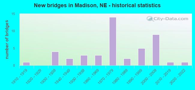
- New bridges - historical statistics
- 11910-1919
- 41930-1939
- 21940-1949
- 31950-1959
- 31960-1969
- 141970-1979
- 21980-1989
- 51990-1999
- 92000-2009
- 12010-2019
- 12020-2022

- Reconstructed bridges - Historical Statistics
- 21970-1979
- 11980-1989
- 11990-1999
- 22000-2009


- Bridge Condition - Deck
- 2.9%Very good
- 14.3%Good
- 25.7%Satisfactory
- 54.3%Fair
- 2.9%Poor

- Bridge Condition - Superstructure
- 17.1%Very good
- 60.0%Good
- 11.4%Satisfactory
- 2.9%Fair
- 5.7%Poor
- 2.9%Serious

- Bridge Condition - Substructure
- 14.3%Very good
- 31.4%Good
- 31.4%Satisfactory
- 8.6%Fair
- 8.6%Poor
- 5.7%Serious

- Bridge Condition - Channel
- 15.6%Excellent
- 35.6%Very good
- 28.9%Good
- 13.3%Satisfactory
- 4.4%Fair
- 2.2%Serious

- Bridge Condition - Culverts
- 40.0%Excellent
- 20.0%Good
- 30.0%Satisfactory
- 10.0%Fair
Find on map >> Show street view
Structure Number: S081 14288R, Location: .5E .2N MADISON (Lat: 41.833000, Lng: -97.442200), Route carried "on" structure: US 81, Year Built: 1978, Status: Open, Structure Length: 6.16m (20.21ft), Average Daily Traffic: 9,010 (year 2018), Truck Traffic: 15%, Average Future Daily Traffic: 13,515 (year 2038), Design Load: HS 20, Features Intersected: UNION CREEK
Minimum Vertical Clearance: 30+ m (98+ ft), Kilometerpoint: 22.994, Lanes on structure: 2, Base Highway Network: Yes, Owner: State Highway Agency, Approaching Roadway Width: 10.7m (35.1ft), Skew: 1 degrees, Material/Design: Steel continuous, Design/Construction: Stringer/Multi-beam, Number Of Spans In Main Unit: 3, Length of Maximum Span: 23.2m (76.1ft), Curb-To-Curb Width: 12.2m (40.0ft), Out-to-Out Width: 13.1m (43.0ft)
Condition: Deck: Satisfactory, Superstructure: Good, Substructure: Good, Channel: Very good, Operating Rating: 60.0 metric tons, Method Used To Determine Operating Rating: Load Factor (LF), Inventory Rating: 35.0 metric tons, Method Used To Determine Inventory Rating: Load Factor (LF), Structural Evaluation: Better than present minimum criteria, Deck Geometry: Better than present minimum criteria, Waterway Adequacy: Equal to present desirable criteria, Approach Roadway Alignment: Equal to present desirable criteria, Designated Inspection Frequency: Every 24 months, Inspection Date: May 2021, Deck Structure Type: Concrete Cast-file-Place, Wearing Surface/Protective System: Wearing Surface: Monolithic Concrete, Deck Protection: Epoxy Coated Reinforcing
Find on map >> Show street view
Structure Number: S081 14448, Location: 7N MADISON (Lat: 41.855800, Lng: -97.440900), Route carried "on" structure: US 81, Year Built: 1978, Year Reconstructed: 1992, Status: Open, Structure Length: 1.07m (3.51ft), Average Daily Traffic: 9,010 (year 2018), Truck Traffic: 15%, Average Future Daily Traffic: 13,515 (year 2038), Features Intersected: STREAM
Minimum Vertical Clearance: 30+ m (98+ ft), Kilometerpoint: 23.252, Lanes on structure: 4, Base Highway Network: Yes, Owner: State Highway Agency, Approaching Roadway Width: 21.3m (69.9ft), Skew: 2 degrees, Material/Design: Concrete, Design/Construction: Culvert, Number Of Spans In Main Unit: 3, Length of Maximum Span: 3.0m (9.8ft)
Condition: Channel: Good, Culverts: Fair, Operating Rating: 33.0 metric tons, Method Used To Determine Operating Rating: Field evaluation and documented engineering judgment, Inventory Rating: 22.0 metric tons, Method Used To Determine Inventory Rating: Field evaluation and documented engineering judgment, Structural Evaluation: Somewhat better than minimum adequacy, Waterway Adequacy: Equal to present desirable criteria, Approach Roadway Alignment: Equal to present desirable criteria, Designated Inspection Frequency: Every 24 months, Inspection Date: May 2021