Bridge Statistics for Malvern, Arkansas (AR)
Condition, Traffic, Stress, Structural Evaluation, Project Costs
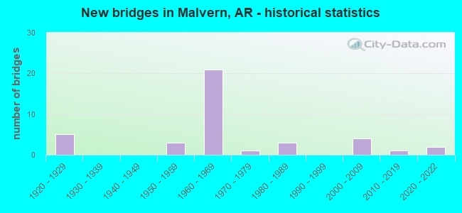
- New bridges - historical statistics
- 51920-1929
- 31950-1959
- 211960-1969
- 11970-1979
- 31980-1989
- 42000-2009
- 12010-2019
- 22020-2022
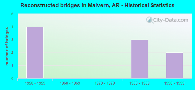
- Reconstructed bridges - Historical Statistics
- 41950-1959
- 01960-1969
- 01970-1979
- 31980-1989
- 21990-1999
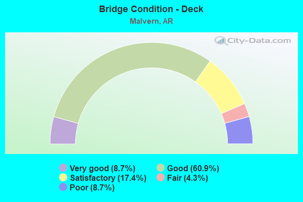
- Bridge Condition - Deck
- 8.7%Very good
- 60.9%Good
- 17.4%Satisfactory
- 4.3%Fair
- 8.7%Poor
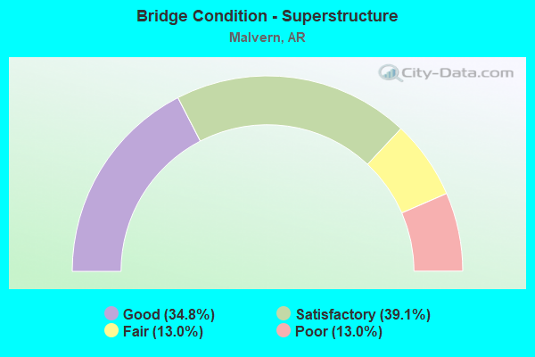
- Bridge Condition - Superstructure
- 34.8%Good
- 39.1%Satisfactory
- 13.0%Fair
- 13.0%Poor
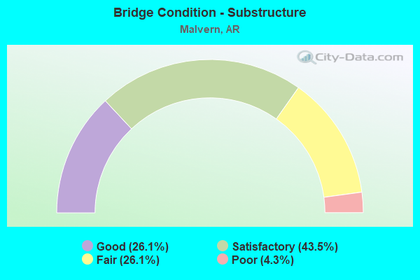
- Bridge Condition - Substructure
- 26.1%Good
- 43.5%Satisfactory
- 26.1%Fair
- 4.3%Poor
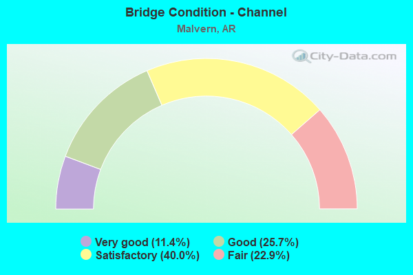
- Bridge Condition - Channel
- 11.4%Very good
- 25.7%Good
- 40.0%Satisfactory
- 22.9%Fair
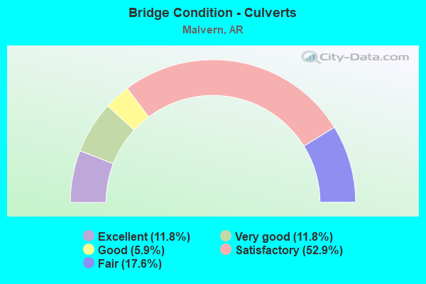
- Bridge Condition - Culverts
- 11.8%Excellent
- 11.8%Very good
- 5.9%Good
- 52.9%Satisfactory
- 17.6%Fair
Find on map >> Show street view
Structure Number: 5026, Location: .64 MI NE SOCIAL HILL (Lat: 34.348281, Lng: -92.896889), Route carried "under" structure: Interstate 30, Structure Length: 0. m, Average Daily Traffic: 15,000 (year 2014), Truck Traffic: 1%, Features Intersected: I-30 Log 92.75
Minimum Vertical Clearance: 4.90m (16.08ft), Kilometerpoint: 149.234, Length of Maximum Span: 0.0m
Find on map >> Show street view
Structure Number: 5028, Location: 1 MI S JCT 270 & I-30 IC (Lat: 34.386039, Lng: -92.846031), Route carried "under" structure: Interstate 30, Structure Length: 0. m, Average Daily Traffic: 15,000 (year 2014), Truck Traffic: 1%, Features Intersected: I-30 Log 96.69, Facility Carried by Structure: SH 84- 6 Log 21.05
Minimum Vertical Clearance: 5.33m (17.49ft), Kilometerpoint: 155.574, Length of Maximum Span: 0.0m
Find on map >> Show street view
Structure Number: 5028, Location: 1 MI S JCT 270 & I-30 IC (Lat: 34.386039, Lng: -92.846031), Route carried "under" structure: Interstate 30, Structure Length: 0. m, Average Daily Traffic: 19,500 (year 2014), Truck Traffic: 1%, Features Intersected: I-30 Log 96.69, Facility Carried by Structure: SH 84- 6 Log 21.05
Minimum Vertical Clearance: 5.08m (16.67ft), Kilometerpoint: 155.607, Length of Maximum Span: 0.0m
Find on map >> Show street view
Structure Number: 5177, Location: .75 MI NW JCT US 270 & 67 (Lat: 34.372069, Lng: -92.822839), Route carried "under" structure: City street 43930, Structure Length: 0. m, Average Daily Traffic: 737 (year 1983), Truck Traffic: 1%, Features Intersected: PARK DRIVE, UPRR, Facility Carried by Structure: US 270-SEC 7B
Minimum Vertical Clearance: 6.79m (22.28ft), Kilometerpoint: 1.497, Length of Maximum Span: 0.0m
Find on map >> Show street view
Structure Number: A3424, Location: 1.0 MI SO I-30 & 270 (Lat: 34.389469, Lng: -92.840781), Route carried "under" structure: City street 49160, Structure Length: 0. m, Average Daily Traffic: 36 (year 1983), Truck Traffic: 1%, Features Intersected: Ouachita Rvr& Riverview, Facility Carried by Structure: I-30 WB Log 97.06
Minimum Vertical Clearance: 4.63m (15.19ft), Kilometerpoint: 0.370, Length of Maximum Span: 0.0m
Find on map >> Show street view
Structure Number: A3426, Location: JCT I-30 & US 270 (Lat: 34.397581, Lng: -92.827061), Route carried "under" structure: Interstate 30, Structure Length: 0. m, Average Daily Traffic: 16,500 (year 2014), Truck Traffic: 1%, Features Intersected: I-30 Log 97.98, Facility Carried by Structure: US 270 WB
Minimum Vertical Clearance: 5.05m (16.57ft), Kilometerpoint: 157.700, Length of Maximum Span: 0.0m
Find on map >> Show street view
Structure Number: A3426, Location: JCT I-30 & US 270 (Lat: 34.397581, Lng: -92.827061), Route carried "under" structure: Interstate 30, Structure Length: 0. m, Average Daily Traffic: 16,500 (year 2014), Truck Traffic: 1%, Features Intersected: I-30 Log 97.98, Facility Carried by Structure: US 270 WB
Minimum Vertical Clearance: 5.41m (17.75ft), Kilometerpoint: 157.700, Length of Maximum Span: 0.0m
Find on map >> Show street view
Structure Number: A5025, Location: 6.24 MI SW OF SH 270 (Lat: 34.340439, Lng: -92.911064), Route carried "under" structure: County highway 800, Structure Length: 0. m, Average Daily Traffic: 100 (year 2002), Truck Traffic: 1%, Features Intersected: Blakley Crk, Acme Pit Rd, Facility Carried by Structure: I-30 WB Log 91.76
Minimum Vertical Clearance: 5.42m (17.78ft), Kilometerpoint: 0.113, Length of Maximum Span: 0.0m
Find on map >> Show street view
Structure Number: B3424, Location: 1 MI S OF JCT 270 (Lat: 34.389281, Lng: -92.840614), Route carried "under" structure: City street 49160, Structure Length: 0. m, Average Daily Traffic: 200 (year 1983), Truck Traffic: 1%, Features Intersected: Ouachita Rvr; Riverview, Facility Carried by Structure: I-30 EB Log 97.06
Minimum Vertical Clearance: 4.60m (15.09ft), Kilometerpoint: 0.386, Length of Maximum Span: 0.0m
Find on map >> Show street view
Structure Number: B3426, Location: JCT HWY 270 & I30 (Lat: 34.397519, Lng: -92.827231), Route carried "under" structure: Interstate 30, Structure Length: 0. m, Average Daily Traffic: 19,500 (year 2014), Truck Traffic: 1%, Features Intersected: I-30 Log 97.98, Facility Carried by Structure: US 270 E.B.
Minimum Vertical Clearance: 5.54m (18.18ft), Kilometerpoint: 157.684, Length of Maximum Span: 0.0m
Find on map >> Show street view
Structure Number: B3426, Location: JCT HWY 270 & I30 (Lat: 34.397519, Lng: -92.827231), Route carried "under" structure: Interstate 30, Structure Length: 0. m, Average Daily Traffic: 19,500 (year 2014), Truck Traffic: 1%, Features Intersected: I-30 Log 97.98, Facility Carried by Structure: US 270 E.B.
Minimum Vertical Clearance: 5.68m (18.64ft), Kilometerpoint: 157.684, Length of Maximum Span: 0.0m
Find on map >> Show street view
Structure Number: B5025, Location: 6.24 MI SO W OF US 270 (Lat: 34.340272, Lng: -92.910867), Route carried "under" structure: Spur County highway 800, Structure Length: 0. m, Average Daily Traffic: 100 (year 1983), Features Intersected: Blakley Crk, Acme Pit Rd, Facility Carried by Structure: I-30 EB Log 91.77
Minimum Vertical Clearance: 5.12m (16.80ft), Kilometerpoint: 0.113, Length of Maximum Span: 0.0m