Bridge Statistics for Mansfield, Pennsylvania (PA)
Condition, Traffic, Stress, Structural Evaluation, Project Costs
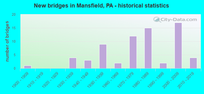
- New bridges - historical statistics
- 11900-1909
- 41930-1939
- 31940-1949
- 91950-1959
- 21960-1969
- 121970-1979
- 151980-1989
- 21990-1999
- 172000-2009
- 42010-2019

- Reconstructed bridges - Historical Statistics
- 51980-1989
- 61990-1999
- 12000-2009
- 12010-2019


- Bridge Condition - Deck
- 2.1%Excellent
- 14.9%Very good
- 51.1%Good
- 19.1%Satisfactory
- 10.6%Fair
- 2.1%Poor

- Bridge Condition - Superstructure
- 19.1%Very good
- 34.0%Good
- 21.3%Satisfactory
- 23.4%Fair
- 2.1%Poor

- Bridge Condition - Substructure
- 6.4%Very good
- 40.4%Good
- 25.5%Satisfactory
- 25.5%Fair
- 2.1%Poor

- Bridge Condition - Channel
- 8.5%Very good
- 29.8%Good
- 19.1%Satisfactory
- 29.8%Fair
- 12.8%Poor

- Bridge Condition - Culverts
- 22.2%Very good
- 44.4%Good
- 33.3%Satisfactory
Find on map >> Show street view
Structure Number: 41459, Location: 1 MI S. OF MANSFIELD (Lat: 41.780986, Lng: -77.077894), Route carried "on" structure: US 15, Year Built: 2001, Status: Open, Structure Length: 3.23m (10.60ft), Average Daily Traffic: 4,202 (year 2020), Truck Traffic: 29%, Average Future Daily Traffic: 9,391 (year 2032), Design Load: HL 93, Features Intersected: TWP ROAD 493
Minimum Vertical Clearance: 30+ m (98+ ft), Kilometerpoint: 29.377, Lanes on structure: 2, Lanes under structure: 2, Base Highway Network: Yes, Owner: State Highway Agency, Approaching Roadway Width: 11.6m (38.1ft), Skew: 1 degrees, Material/Design: Prestressed concrete, Design/Construction: Stringer/Multi-beam, Number Of Spans In Main Unit: 1, Length of Maximum Span: 30.5m (100.1ft), Curb or Sidewalk Widths: Left: 0.2m (0.7ft), Right: 0.2m (0.7ft), Curb-To-Curb Width: 11.9m (39.0ft), Out-to-Out Width: 12.9m (42.3ft)
Condition: Deck: Very good, Superstructure: Very good, Substructure: Very good, Operating Rating: 71.7 metric tons, Method Used To Determine Operating Rating: Load and Resistance Factor (LRFR), Inventory Rating: 41.7 metric tons, Method Used To Determine Inventory Rating: Load and Resistance Factor (LRFR), Structural Evaluation: Equal to present desirable criteria, Deck Geometry: Better than present minimum criteria, Underclear: Superior to present desirable criteria, Approach Roadway Alignment: Equal to present desirable criteria, Length Of Structure Improvement: 4.10m (13.45ft), Designated Inspection Frequency: Every 48 months, Inspection Date: July 2019, Deck Structure Type: Concrete Cast-file-Place, Wearing Surface/Protective System: Wearing Surface: Epoxy Overlay, Deck Protection: Epoxy Coated Reinforcing
Find on map >> Show street view
Structure Number: 4146, Location: 0.5 M NW OF MANSFIELD (Lat: 41.818883, Lng: -77.089969), Route carried "on" structure: Bypass US 15, Year Built: 2001, Status: Open, Structure Length: 4.51m (14.80ft), Average Daily Traffic: 5,377 (year 2022), Truck Traffic: 23%, Average Future Daily Traffic: 4,616 (year 2032), Design Load: HL 93, Features Intersected: OVER SR 1001
Minimum Vertical Clearance: 30+ m (98+ ft), Kilometerpoint: 33.857, Lanes on structure: 2, Lanes under structure: 2, Base Highway Network: Yes, Owner: State Highway Agency, Approaching Roadway Width: 11.3m (37.1ft), Skew: 3 degrees, Material/Design: Prestressed concrete, Design/Construction: Stringer/Multi-beam, Number Of Spans In Main Unit: 1, Length of Maximum Span: 42.7m (140.1ft), Curb or Sidewalk Widths: Left: 0.2m (0.7ft), Right: 0.2m (0.7ft), Curb-To-Curb Width: 11.9m (39.0ft), Out-to-Out Width: 13.0m (42.7ft)
Condition: Deck: Very good, Superstructure: Very good, Substructure: Good, Operating Rating: 96.2 metric tons, Method Used To Determine Operating Rating: Load Factor (LF), Inventory Rating: 39.9 metric tons, Method Used To Determine Inventory Rating: Load Factor (LF), Structural Evaluation: Better than present minimum criteria, Deck Geometry: Better than present minimum criteria, Underclear: High priority of corrective action, Approach Roadway Alignment: Equal to present desirable criteria, Length Of Structure Improvement: 5.50m (18.04ft), Designated Inspection Frequency: Every 48 months, Inspection Date: July 2019, Deck Structure Type: Concrete Cast-file-Place, Wearing Surface/Protective System: Wearing Surface: Epoxy Overlay, Deck Protection: Epoxy Coated Reinforcing
Find on map >> Show street view
Structure Number: 41461, Location: 0.5 MI N OF MANSFIELD (Lat: 41.823792, Lng: -77.088186), Route carried "on" structure: Bypass US 15, Year Built: 2001, Status: Open, Structure Length: 16.46m (54.00ft), Average Daily Traffic: 5,377 (year 2022), Truck Traffic: 23%, Average Future Daily Traffic: 4,616 (year 2032), Design Load: HL 93, Features Intersected: TIOGA RIVER & SR 8003
Minimum Vertical Clearance: 30+ m (98+ ft), Kilometerpoint: 34.318, Lanes on structure: 2, Lanes under structure: 2, Base Highway Network: Yes, Owner: State Highway Agency, Approaching Roadway Width: 11.3m (37.1ft), Skew: 13 degrees, Material/Design: Prestressed concrete continuous, Design/Construction: Stringer/Multi-beam, Number Of Spans In Main Unit: 4, Length of Maximum Span: 40.8m (133.9ft), Curb or Sidewalk Widths: Left: 0.2m (0.7ft), Right: 0.2m (0.7ft), Curb-To-Curb Width: 11.9m (39.0ft), Out-to-Out Width: 12.9m (42.3ft)
Condition: Deck: Good, Superstructure: Very good, Substructure: Good, Channel: Good, Operating Rating: 67.1 metric tons, Method Used To Determine Operating Rating: Load and Resistance Factor (LRFR), Inventory Rating: 39.0 metric tons, Method Used To Determine Inventory Rating: Load and Resistance Factor (LRFR), Structural Evaluation: Better than present minimum criteria, Deck Geometry: Better than present minimum criteria, Underclear: Superior to present desirable criteria, Waterway Adequacy: Superior to present desirable criteria, Approach Roadway Alignment: Equal to present desirable criteria, Length Of Structure Improvement: 16.50m (54.13ft), Designated Inspection Frequency: Every 48 months, Inspection Date: July 2019, Deck Structure Type: Concrete Cast-file-Place, Wearing Surface/Protective System: Wearing Surface: Epoxy Overlay, Deck Protection: Epoxy Coated Reinforcing
Find on map >> Show street view
Structure Number: 42126, Location: 0.4 MI W OF CANOE CAMP (Lat: 41.785914, Lng: -77.075578), Route carried "on" structure: City street , Year Built: 2003, Status: Open, Structure Length: 0.61m (2.00ft), Average Daily Traffic: 50 (year 2021), Average Future Daily Traffic: 77 (year 2043), Features Intersected: SLATE CREEK, Facility Carried by Structure: T-754 RICHMOND TWP
Minimum Vertical Clearance: 30+ m (98+ ft), Kilometerpoint: 0.000, Lanes on structure: 2, Owner: Town or Township Highway Agency, Approaching Roadway Width: 8.5m (27.9ft), Material/Design: Concrete, Design/Construction: Culvert, Number Of Spans In Main Unit: 1, Length of Maximum Span: 6.1m (20.0ft)
Condition: Channel: Fair, Culverts: Good, Operating Rating: 89.8 metric tons, Method Used To Determine Operating Rating: Load and Resistance Factor (LRFR), Inventory Rating: 69.9 metric tons, Method Used To Determine Inventory Rating: Load and Resistance Factor (LRFR), Structural Evaluation: Better than present minimum criteria, Waterway Adequacy: Superior to present desirable criteria, Approach Roadway Alignment: Equal to present desirable criteria, Length Of Structure Improvement: 0.60m (1.97ft), Designated Inspection Frequency: Every 24 months, Inspection Date: June 2021
Find on map >> Show street view
Structure Number: 42227, Location: BORO. OF MANSFIELD (Lat: 41.774678, Lng: -77.072031), Route carried "on" structure: US 15, Year Built: 2003, Status: Open, Structure Length: 3.72m (12.20ft), Average Daily Traffic: 4,202 (year 2020), Truck Traffic: 29%, Average Future Daily Traffic: 9,391 (year 2032), Design Load: HL 93, Features Intersected: NB OVER SR 2005
Minimum Vertical Clearance: 30+ m (98+ ft), Kilometerpoint: 28.521, Lanes on structure: 2, Lanes under structure: 2, Base Highway Network: Yes, Owner: State Highway Agency, Approaching Roadway Width: 15.5m (50.9ft), Skew: 13 degrees, Material/Design: Prestressed concrete, Design/Construction: Stringer/Multi-beam, Number Of Spans In Main Unit: 1, Length of Maximum Span: 34.7m (113.8ft), Curb or Sidewalk Widths: Left: 0.2m (0.7ft), Right: 0.2m (0.7ft), Curb-To-Curb Width: 16.9m (55.4ft), Out-to-Out Width: 17.9m (58.7ft)
Condition: Deck: Good, Superstructure: Very good, Substructure: Good, Operating Rating: 86.2 metric tons, Method Used To Determine Operating Rating: Load and Resistance Factor (LRFR), Inventory Rating: 43.5 metric tons, Method Used To Determine Inventory Rating: Load and Resistance Factor (LRFR), Structural Evaluation: Better than present minimum criteria, Deck Geometry: Superior to present desirable criteria, Underclear: Superior to present desirable criteria, Approach Roadway Alignment: Equal to present desirable criteria, Length Of Structure Improvement: 4.40m (14.44ft), Designated Inspection Frequency: Every 48 months, Inspection Date: July 2019, Deck Structure Type: Concrete Cast-file-Place, Wearing Surface/Protective System: Wearing Surface: Epoxy Overlay, Deck Protection: Epoxy Coated Reinforcing
Find on map >> Show street view
Structure Number: 42228, Location: BORO OF MANSFIELD (Lat: 41.774511, Lng: -77.072144), Route carried "on" structure: US 15, Year Built: 2003, Status: Open, Structure Length: 3.72m (12.20ft), Average Daily Traffic: 4,148 (year 2020), Truck Traffic: 27%, Average Future Daily Traffic: 7,130 (year 2032), Design Load: HL 93, Features Intersected: SB OVER SR 2005
Minimum Vertical Clearance: 30+ m (98+ ft), Kilometerpoint: 28.497, Lanes on structure: 2, Lanes under structure: 2, Base Highway Network: Yes, Owner: State Highway Agency, Approaching Roadway Width: 11.9m (39.0ft), Skew: 13 degrees, Material/Design: Prestressed concrete, Design/Construction: Stringer/Multi-beam, Number Of Spans In Main Unit: 1, Length of Maximum Span: 34.7m (113.8ft), Curb or Sidewalk Widths: Left: 0.2m (0.7ft), Right: 0.2m (0.7ft), Curb-To-Curb Width: 12.0m (39.4ft), Out-to-Out Width: 12.9m (42.3ft)
Condition: Deck: Good, Superstructure: Very good, Substructure: Very good, Operating Rating: 84.4 metric tons, Method Used To Determine Operating Rating: Load and Resistance Factor (LRFR), Inventory Rating: 42.6 metric tons, Method Used To Determine Inventory Rating: Load and Resistance Factor (LRFR), Structural Evaluation: Equal to present desirable criteria, Deck Geometry: Better than present minimum criteria, Underclear: Superior to present desirable criteria, Approach Roadway Alignment: Equal to present desirable criteria, Length Of Structure Improvement: 4.50m (14.76ft), Designated Inspection Frequency: Every 48 months, Inspection Date: July 2019, Deck Structure Type: Concrete Cast-file-Place, Wearing Surface/Protective System: Wearing Surface: Epoxy Overlay, Deck Protection: Epoxy Coated Reinforcing
Find on map >> Show street view
Structure Number: 42239, Location: BORO OF MANSFIELD (Lat: 41.803842, Lng: -77.091514), Route carried "on" structure: Bypass US 15, Year Built: 2003, Status: Open, Structure Length: 4.33m (14.21ft), Average Daily Traffic: 4,202 (year 2020), Truck Traffic: 29%, Average Future Daily Traffic: 9,391 (year 2032), Design Load: HL 93, Features Intersected: ROUTE 6
Minimum Vertical Clearance: 30+ m (98+ ft), Kilometerpoint: 32.161, Lanes on structure: 3, Lanes under structure: 3, Base Highway Network: Yes, Owner: State Highway Agency, Approaching Roadway Width: 15.2m (49.9ft), Material/Design: Prestressed concrete, Design/Construction: Stringer/Multi-beam, Number Of Spans In Main Unit: 1, Length of Maximum Span: 41.5m (136.2ft), Curb-To-Curb Width: 15.7m (51.5ft), Out-to-Out Width: 16.7m (54.8ft)
Condition: Deck: Very good, Superstructure: Very good, Substructure: Good, Operating Rating: 89.8 metric tons, Method Used To Determine Operating Rating: Load and Resistance Factor (LRFR), Inventory Rating: 39.9 metric tons, Method Used To Determine Inventory Rating: Load and Resistance Factor (LRFR), Structural Evaluation: Better than present minimum criteria, Deck Geometry: Better than present minimum criteria, Underclear: Superior to present desirable criteria, Approach Roadway Alignment: Equal to present desirable criteria, Length Of Structure Improvement: 5.20m (17.06ft), Designated Inspection Frequency: Every 48 months, Inspection Date: July 2019, Deck Structure Type: Concrete Cast-file-Place, Wearing Surface/Protective System: Wearing Surface: Epoxy Overlay, Deck Protection: Epoxy Coated Reinforcing
Find on map >> Show street view
Structure Number: 42277, Location: 1.5 MILE S. MANSFIELD (Lat: 41.777050, Lng: -77.074236), Route carried "on" structure: Bypass US 15, Year Built: 2003, Status: Open, Structure Length: 14.39m (47.21ft), Average Daily Traffic: 4,202 (year 2020), Truck Traffic: 29%, Average Future Daily Traffic: 9,391 (year 2032), Design Load: HL 93, Features Intersected: TIOGA RIVER
Minimum Vertical Clearance: 30+ m (98+ ft), Kilometerpoint: 28.521, Lanes on structure: 2, Base Highway Network: Yes, Owner: State Highway Agency, Approaching Roadway Width: 12.8m (42.0ft), Skew: 13 degrees, Material/Design: Prestressed concrete continuous, Design/Construction: Stringer/Multi-beam, Number Of Spans In Main Unit: 4, Length of Maximum Span: 36.9m (121.1ft), Curb or Sidewalk Widths: Left: 0.2m (0.7ft), Right: 0.2m (0.7ft), Curb-To-Curb Width: 13.5m (44.3ft), Out-to-Out Width: 14.4m (47.2ft)
Condition: Deck: Very good, Superstructure: Very good, Substructure: Good, Channel: Very good, Operating Rating: 87.1 metric tons, Method Used To Determine Operating Rating: Load and Resistance Factor (LRFR), Inventory Rating: 45.4 metric tons, Method Used To Determine Inventory Rating: Load and Resistance Factor (LRFR), Structural Evaluation: Better than present minimum criteria, Deck Geometry: Superior to present desirable criteria, Waterway Adequacy: Superior to present desirable criteria, Approach Roadway Alignment: Equal to present desirable criteria, Length Of Structure Improvement: 15.20m (49.87ft), Designated Inspection Frequency: Every 48 months, Inspection Date: July 2019, Deck Structure Type: Concrete Cast-file-Place, Wearing Surface/Protective System: Wearing Surface: Epoxy Overlay, Deck Protection: Epoxy Coated Reinforcing
Find on map >> Show street view
Structure Number: 46057, Location: 1.25 MI NE OF MANSFIELD (Lat: 41.816853, Lng: -77.056350), Route carried "on" structure: State highway , Year Built: 2010, Status: Open, Structure Length: 0.85m (2.79ft), Average Daily Traffic: 409 (year 2021), Truck Traffic: 7%, Average Future Daily Traffic: 627 (year 2032), Design Load: HL 93, Features Intersected: TRIB COREY CREEK, Facility Carried by Structure: SR 1002
Minimum Vertical Clearance: 30+ m (98+ ft), Kilometerpoint: 2.163, Lanes on structure: 2, Owner: State Highway Agency, Approaching Roadway Width: 4.6m (15.1ft), Skew: 5 degrees, Material/Design: Concrete, Design/Construction: Culvert, Number Of Spans In Main Unit: 1, Length of Maximum Span: 8.2m (26.9ft), Curb-To-Curb Width: 11.6m (38.1ft), Out-to-Out Width: 13.1m (43.0ft)
Condition: Channel: Poor, Culverts: Very good, Operating Rating: 65.3 metric tons, Method Used To Determine Operating Rating: Load and Resistance Factor (LRFR), Inventory Rating: 50.8 metric tons, Method Used To Determine Inventory Rating: Load and Resistance Factor (LRFR), Structural Evaluation: Equal to present desirable criteria, Deck Geometry: Better than present minimum criteria, Waterway Adequacy: Superior to present desirable criteria, Approach Roadway Alignment: Equal to present desirable criteria, Designated Inspection Frequency: Every 48 months, Inspection Date: July 2019
Find on map >> Show street view
Structure Number: 46692, Location: VILLAGE OF PENNS CREEK (Lat: 41.856944, Lng: -77.056111), Route carried "on" structure: State highway , Year Built: 2011, Status: Open, Structure Length: 2.10m (6.89ft), Average Daily Traffic: 532 (year 2020), Truck Traffic: 9%, Average Future Daily Traffic: 723 (year 2032), Design Load: HL 93, Features Intersected: DRY RUN, Facility Carried by Structure: SR 1001
Minimum Vertical Clearance: 30+ m (98+ ft), Kilometerpoint: 4.854, Lanes on structure: 2, Owner: State Highway Agency, Approaching Roadway Width: 8.5m (27.9ft), Material/Design: Prestressed concrete, Design/Construction: Box Beam or Girders - Single/Spread, Number Of Spans In Main Unit: 1, Length of Maximum Span: 20.1m (65.9ft), Curb or Sidewalk Widths: Left: 0.2m (0.7ft), Right: 0.2m (0.7ft), Curb-To-Curb Width: 8.5m (27.9ft), Out-to-Out Width: 9.5m (31.2ft)
Condition: Deck: Good, Superstructure: Very good, Substructure: Very good, Channel: Good, Operating Rating: 63.8 metric tons, Method Used To Determine Operating Rating: Assigned ratings based on Load and Resistance Factor Design (LRFD) reported by rating factor (RF) using HL93 loadings, Inventory Rating: 40.2 metric tons, Method Used To Determine Inventory Rating: Assigned ratings based on Load and Resistance Factor Design (LRFD) reported by rating factor (RF) using HL93 loadings, Structural Evaluation: Equal to present desirable criteria, Deck Geometry: Somewhat better than minimum adequacy, Waterway Adequacy: Equal to present desirable criteria, Approach Roadway Alignment: Equal to present minimum criteria, Designated Inspection Frequency: Every 48 months, Inspection Date: Febuary 2020, Deck Structure Type: Concrete Cast-file-Place, Wearing Surface/Protective System: Wearing Surface: Epoxy Overlay, Deck Protection: Epoxy Coated Reinforcing
Find on map >> Show street view
Structure Number: 47318, Location: 0.4 MI WEST OF COVINGTON (Lat: 41.746283, Lng: -77.083753), Route carried "on" structure: City street , Year Built: 2012, Status: Open, Structure Length: 0.91m (2.99ft), Average Daily Traffic: 120 (year 2021), Average Future Daily Traffic: 186 (year 2043), Design Load: HL 93, Features Intersected: TRIB TO TIOGA RIVER, Facility Carried by Structure: T-750 KENDRICK RD
Minimum Vertical Clearance: 30+ m (98+ ft), Kilometerpoint: 0.000, Lanes on structure: 2, Owner: Town or Township Highway Agency, Approaching Roadway Width: 4.9m (16.1ft), Material/Design: Concrete, Design/Construction: Culvert, Number Of Spans In Main Unit: 1, Length of Maximum Span: 8.5m (27.9ft), Curb-To-Curb Width: 6.7m (22.0ft), Out-to-Out Width: 7.8m (25.6ft)
Condition: Channel: Good, Culverts: Very good, Operating Rating: 57.0 metric tons, Method Used To Determine Operating Rating: Assigned ratings based on Load and Resistance Factor Design (LRFD) reported by rating factor (RF) using HL93 loadings, Inventory Rating: 35.6 metric tons, Method Used To Determine Inventory Rating: Assigned ratings based on Load and Resistance Factor Design (LRFD) reported by rating factor (RF) using HL93 loadings, Structural Evaluation: Equal to present desirable criteria, Deck Geometry: Meets minimum limits, Waterway Adequacy: Superior to present desirable criteria, Approach Roadway Alignment: Equal to present desirable criteria, Designated Inspection Frequency: Every 24 months, Inspection Date: June 2021, Wearing Surface/Protective System: Wearing Surface: Bituminous, Membrane: Preformed Fabric, Deck Protection: Epoxy Coated Reinforcing
Find on map >> Show street view
Structure Number: 56871, Location: 2.8M E OF WHITNEYVILLE (Lat: 41.775100, Lng: -77.146428), Route carried "on" structure: City street , Year Built: 2019, Status: Open, Structure Length: 0.67m (2.20ft), Average Daily Traffic: 50 (year 2021), Average Future Daily Traffic: 61 (year 2043), Design Load: HS 20, Features Intersected: NORTH ELK RUN, Facility Carried by Structure: T-678 (S. BULLOCK)
Minimum Vertical Clearance: 30+ m (98+ ft), Kilometerpoint: 0.000, Lanes on structure: 2, Owner: Town or Township Highway Agency, Approaching Roadway Width: 8.5m (27.9ft), Material/Design: Concrete, Design/Construction: Culvert, Number Of Spans In Main Unit: 1, Length of Maximum Span: 6.7m (22.0ft), Curb-To-Curb Width: 9.1m (29.9ft), Out-to-Out Width: 9.8m (32.2ft)
Condition: Channel: Fair, Culverts: Satisfactory, Operating Rating: 45.4 metric tons, Method Used To Determine Operating Rating: Load Factor (LF), Inventory Rating: 27.2 metric tons, Method Used To Determine Inventory Rating: Load Factor (LF), Structural Evaluation: Equal to present minimum criteria, Deck Geometry: Better than present minimum criteria, Waterway Adequacy: Better than present minimum criteria, Approach Roadway Alignment: Equal to present desirable criteria, Designated Inspection Frequency: Every 24 months, Inspection Date: July 2021, Wearing Surface/Protective System: Wearing Surface: Gravel
Find on map >> Show street view
Structure Number: CEPNABPA-000001, Location: INDIAN ROCK DAM, PA (Lat: 39.922394, Lng: -76.753183), Route carried "on" structure: ServiceFederal lands road , Year Built: 1949, Year Reconstructed: 1989, Status: Posted for load, Structure Length: 2.74m (8.99ft), Average Daily Traffic: 400 (year 2021), Truck Traffic: 2%, Average Future Daily Traffic: 500 (year 2037), Design Load: H 15, Features Intersected: INDIAN ROCK DAM, Facility Carried by Structure: ACCESS ROAD
Minimum Vertical Clearance: 30+ m (98+ ft), Kilometerpoint: 0.000, Lanes on structure: 2, Owner: Corps of Engineers (Civil), Approaching Roadway Width: 6.7m (22.0ft), Material/Design: Steel, Design/Construction: Truss - Deck, Number Of Spans In Main Unit: 1, Length of Maximum Span: 26.7m (87.6ft), Curb or Sidewalk Widths: Left: 0.3m (1.0ft), Right: 0.3m (1.0ft), Curb-To-Curb Width: 5.4m (17.7ft), Out-to-Out Width: 6.7m (22.0ft)
Condition: Deck: Satisfactory, Superstructure: Satisfactory, Substructure: Satisfactory, Channel: Very good, Operating Rating: 34.7 metric tons, Method Used To Determine Operating Rating: Load and Resistance Factor Rating (LRFR) rating reported by rating factor(RF) method using HL-93 loadings, Inventory Rating: 26.9 metric tons, Method Used To Determine Inventory Rating: Load and Resistance Factor Rating (LRFR) rating reported by rating factor(RF) method using HL-93 loadings, Structural Evaluation: Equal to present minimum criteria, Deck Geometry: High priority of replacement, Waterway Adequacy: Superior to present desirable criteria, Approach Roadway Alignment: Somewhat better than minimum adequacy, Length Of Structure Improvement: 5.29m (17.36ft), Designated Inspection Frequency: Every 24 months, Critical Feature Inspection Frequency: Every 24 months, Inspection Date: April 2021, Critical Feature Inspection Date: April 2021, Bridge Improvement Cost: $454,000, Roadway Improvement Cost: $1,000, Total Project Cost: $455,000 ( Estimate for 2021), Deck Structure Type: Concrete Cast-file-Place, Wearing Surface/Protective System: Wearing Surface: Monolithic Concrete
Find on map >> Show street view
Structure Number: CEPNABPA-000004, Location: TIOGA-HAMMOND LAKES (Lat: 41.877950, Lng: -77.188569), Route carried "on" structure: ServiceFederal lands road , Year Built: 1979, Status: Posted for load, Structure Length: 1.24m (4.07ft), Average Daily Traffic: 200 (year 2017), Truck Traffic: 5%, Average Future Daily Traffic: 200 (year 2042), Design Load: HS 15, Features Intersected: STEPHENHOUSE RUN, Facility Carried by Structure: ADMIN ACCESS ROAD
Minimum Vertical Clearance: 30+ m (98+ ft), Kilometerpoint: 0.000, Lanes on structure: 2, Owner: Corps of Engineers (Civil), Approaching Roadway Width: 5.4m (17.7ft), Material/Design: Concrete, Design/Construction: Slab, Number Of Spans In Main Unit: 1, Length of Maximum Span: 12.4m (40.7ft), Curb or Sidewalk Widths: Left: 1.1m (3.6ft), Right: 1.1m (3.6ft), Curb-To-Curb Width: 5.4m (17.7ft), Out-to-Out Width: 7.8m (25.6ft)
Condition: Deck: Satisfactory, Superstructure: Satisfactory, Substructure: Fair, Channel: Satisfactory, Operating Rating: 29.2 metric tons, Method Used To Determine Operating Rating: Load and Resistance Factor Rating (LRFR) rating reported by rating factor(RF) method using HL-93 loadings, Inventory Rating: 22.7 metric tons, Method Used To Determine Inventory Rating: Load and Resistance Factor Rating (LRFR) rating reported by rating factor(RF) method using HL-93 loadings, Structural Evaluation: Somewhat better than minimum adequacy, Deck Geometry: High priority of replacement, Waterway Adequacy: Better than present minimum criteria, Approach Roadway Alignment: Equal to present minimum criteria, Length Of Structure Improvement: 0.13m (0.43ft), Designated Inspection Frequency: Every 24 months, Inspection Date: August 2021, Bridge Improvement Cost: $27,000, Roadway Improvement Cost: $1,000, Total Project Cost: $28,000 ( Estimate for 2021), Deck Structure Type: Concrete Cast-file-Place, Wearing Surface/Protective System: Wearing Surface: Integral Concrete
Find on map >> Show street view
Structure Number: CEPNABPA-000005, Location: TIOGA-HAMMOND LAKES (Lat: 41.887325, Lng: -77.178367), Route carried "on" structure: ServiceFederal lands road , Year Built: 1979, Status: Posted for load, Structure Length: 1.24m (4.07ft), Average Daily Traffic: 200 (year 2011), Truck Traffic: 20%, Average Future Daily Traffic: 200 (year 2037), Design Load: HS 15, Features Intersected: IVES RUN, Facility Carried by Structure: CAMP ACCESS ROAD
Minimum Vertical Clearance: 30+ m (98+ ft), Kilometerpoint: 0.000, Lanes on structure: 2, Owner: Corps of Engineers (Civil), Approaching Roadway Width: 6.7m (22.0ft), Skew: 1 degrees, Material/Design: Concrete, Design/Construction: Slab, Number Of Spans In Main Unit: 1, Length of Maximum Span: 12.4m (40.7ft), Curb or Sidewalk Widths: Left: 1.1m (3.6ft), Right: 1.1m (3.6ft), Curb-To-Curb Width: 6.7m (22.0ft), Out-to-Out Width: 9.1m (29.9ft)
Condition: Deck: Satisfactory, Superstructure: Satisfactory, Substructure: Satisfactory, Channel: Good, Operating Rating: 30.5 metric tons, Method Used To Determine Operating Rating: Load and Resistance Factor Rating (LRFR) rating reported by rating factor(RF) method using HL-93 loadings, Inventory Rating: 23.7 metric tons, Method Used To Determine Inventory Rating: Load and Resistance Factor Rating (LRFR) rating reported by rating factor(RF) method using HL-93 loadings, Structural Evaluation: Equal to present minimum criteria, Deck Geometry: Meets minimum limits, Waterway Adequacy: Better than present minimum criteria, Approach Roadway Alignment: Equal to present desirable criteria, Length Of Structure Improvement: 2.46m (8.07ft), Designated Inspection Frequency: Every 24 months, Inspection Date: August 2021, Bridge Improvement Cost: $112,000, Roadway Improvement Cost: $11,000, Total Project Cost: $168,000 ( Estimate for 2021), Deck Structure Type: Concrete Cast-file-Place, Wearing Surface/Protective System: Wearing Surface: Integral Concrete
Find on map >> Show street view
Structure Number: CEPNABPA-000006, Location: TIOGA-HAMMOND LAKES (Lat: 41.888592, Lng: -77.181178), Route carried "on" structure: ServiceFederal lands road , Year Built: 1979, Status: Posted for load, Structure Length: 1.24m (4.07ft), Average Daily Traffic: 700 (year 2021), Truck Traffic: 1%, Average Future Daily Traffic: 700 (year 2039), Design Load: HS 15, Features Intersected: IVES RUN, Facility Carried by Structure: DAY USE ACCESS RD
Minimum Vertical Clearance: 30+ m (98+ ft), Kilometerpoint: 0.000, Lanes on structure: 2, Owner: Corps of Engineers (Civil), Approaching Roadway Width: 6.7m (22.0ft), Skew: 2 degrees, Material/Design: Concrete, Design/Construction: Slab, Number Of Spans In Main Unit: 1, Length of Maximum Span: 12.4m (40.7ft), Curb or Sidewalk Widths: Left: 0.3m (1.0ft), Right: 0.3m (1.0ft), Curb-To-Curb Width: 6.7m (22.0ft), Out-to-Out Width: 9.1m (29.9ft)
Condition: Deck: Good, Superstructure: Good, Substructure: Good, Channel: Good, Operating Rating: 31.4 metric tons, Method Used To Determine Operating Rating: Load and Resistance Factor Rating (LRFR) rating reported by rating factor(RF) method using HL-93 loadings, Inventory Rating: 24.3 metric tons, Method Used To Determine Inventory Rating: Load and Resistance Factor Rating (LRFR) rating reported by rating factor(RF) method using HL-93 loadings, Structural Evaluation: Equal to present minimum criteria, Deck Geometry: Meets minimum limits, Waterway Adequacy: Better than present minimum criteria, Approach Roadway Alignment: Better than present minimum criteria, Length Of Structure Improvement: 2.46m (8.07ft), Designated Inspection Frequency: Every 24 months, Inspection Date: August 2021, Bridge Improvement Cost: $33,000, Roadway Improvement Cost: $1,000, Total Project Cost: $34,000 ( Estimate for 2021), Deck Structure Type: Concrete Cast-file-Place, Wearing Surface/Protective System: Wearing Surface: Integral Concrete
Find on map >> Show street view
Structure Number: CEPNABPA-000007, Location: TIOGA-HAMMOND LAKES (Lat: 41.841547, Lng: -77.103217), Route carried "on" structure: Federal lands road , Year Built: 1936, Year Reconstructed: 1988, Status: Closed, Structure Length: 5.15m (16.90ft), Average Future Daily Traffic: 1 (year 2041), Features Intersected: LAMBS CREEK, Facility Carried by Structure: LAMBS CR ACCESS RD
Minimum Vertical Clearance: 4.03m (13.22ft), Kilometerpoint: 0.000, Lanes on structure: 2, Owner: Corps of Engineers (Civil), Approaching Roadway Width: 6.7m (22.0ft), Material/Design: Steel, Design/Construction: Truss - Thru, Number Of Spans In Main Unit: 1, Length of Maximum Span: 51.5m (169.0ft), Curb or Sidewalk Widths: Left: 0.3m (1.0ft), Right: 0.3m (1.0ft), Curb-To-Curb Width: 7.0m (23.0ft), Out-to-Out Width: 7.8m (25.6ft)
Condition: Deck: Very good, Superstructure: Good, Substructure: Satisfactory, Channel: Satisfactory, Length Of Structure Improvement: 9.63m (31.59ft), Designated Inspection Frequency: Every 24 months, Inspection Date: August 2021, Bridge Improvement Cost: $33,000, Roadway Improvement Cost: $3,000, Total Project Cost: $50,000 ( Estimate for 2021), Deck Structure Type: Concrete Cast-file-Place, Wearing Surface/Protective System: Wearing Surface: Monolithic Concrete
Find on map >> Show street view
Structure Number: 33228, Location: BORO OF MANSFIELD (Lat: 41.803839, Lng: -77.091750), Route carried "under" structure: US 6, Year Built: 1986, Structure Length: 0. m, Average Daily Traffic: 3,612 (year 2020), Truck Traffic: 8%, Features Intersected: SR 0006, Facility Carried by Structure: SR 15
Minimum Vertical Clearance: 4.82m (15.81ft), Kilometerpoint: 52.125, Lanes on structure: 2, Lanes under structure: 1, Material/Design: Prestressed concrete, Design/Construction: Stringer/Multi-beam, Length of Maximum Span: 31.4m (103.0ft)
Find on map >> Show street view
Structure Number: 33228, Location: BORO OF MANSFIELD (Lat: 41.803839, Lng: -77.091750), Route carried "under" structure: US 6, Year Built: 1986, Structure Length: 0. m, Average Daily Traffic: 3,612 (year 2020), Truck Traffic: 8%, Features Intersected: SR 0006, Facility Carried by Structure: SR 15
Minimum Vertical Clearance: 4.82m (15.81ft), Kilometerpoint: 52.125, Lanes on structure: 2, Lanes under structure: 2, Material/Design: Prestressed concrete, Design/Construction: Stringer/Multi-beam, Length of Maximum Span: 31.4m (103.0ft)
Find on map >> Show street view
Structure Number: 33229, Location: 0.5 MI. NW OF MANSFIELD (Lat: 41.818706, Lng: -77.089794), Route carried "under" structure: State highway , Year Built: 1986, Structure Length: 0. m, Average Daily Traffic: 466 (year 2022), Truck Traffic: 8%, Features Intersected: SR 1001, Facility Carried by Structure: SR 0015
Minimum Vertical Clearance: 4.47m (14.67ft), Kilometerpoint: 6.822, Lanes on structure: 2, Lanes under structure: 2, Material/Design: Prestressed concrete, Design/Construction: Stringer/Multi-beam, Length of Maximum Span: 42.7m (140.1ft)
Find on map >> Show street view
Structure Number: 3323, Location: 0.5 MI. N. OF MANSFIELD (Lat: 41.823586, Lng: -77.087964), Route carried "under" structure: Ramp State highway , Year Built: 1986, Structure Length: 0. m, Average Daily Traffic: 795 (year 2022), Truck Traffic: 8%, Features Intersected: TIOGA RIVER & SR 8003, Facility Carried by Structure: SR 15
Minimum Vertical Clearance: 6.12m (20.08ft), Kilometerpoint: 0.000, Lanes on structure: 2, Lanes under structure: 1, Material/Design: Prestressed concrete continuous, Design/Construction: Stringer/Multi-beam, Length of Maximum Span: 39.6m (129.9ft)
Find on map >> Show street view
Structure Number: 3323, Location: 0.5 MI. N. OF MANSFIELD (Lat: 41.823586, Lng: -77.087964), Route carried "under" structure: Ramp State highway , Year Built: 1986, Structure Length: 0. m, Average Daily Traffic: 832 (year 2022), Truck Traffic: 8%, Features Intersected: TIOGA RIVER & SR 8003, Facility Carried by Structure: SR 15
Minimum Vertical Clearance: 6.12m (20.08ft), Kilometerpoint: 0.000, Lanes on structure: 2, Lanes under structure: 1, Material/Design: Prestressed concrete continuous, Design/Construction: Stringer/Multi-beam, Length of Maximum Span: 39.6m (129.9ft)
Find on map >> Show street view
Structure Number: 41459, Location: 1 MI S. OF MANSFIELD (Lat: 41.780986, Lng: -77.077894), Route carried "under" structure: City street , Year Built: 2001, Structure Length: 0. m, Average Daily Traffic: 310 (year 2009), Truck Traffic: 3%, Features Intersected: TWP ROAD 493, Facility Carried by Structure: SR 15 FUTURE NB
Minimum Vertical Clearance: 6.50m (21.33ft), Kilometerpoint: 0.000, Lanes on structure: 2, Lanes under structure: 2, Material/Design: Prestressed concrete, Design/Construction: Stringer/Multi-beam, Length of Maximum Span: 30.5m (100.1ft)
Find on map >> Show street view
Structure Number: 4146, Location: 0.5 M NW OF MANSFIELD (Lat: 41.818883, Lng: -77.089969), Route carried "under" structure: State highway , Year Built: 2001, Structure Length: 0. m, Average Daily Traffic: 466 (year 2022), Truck Traffic: 8%, Features Intersected: OVER SR 1001, Facility Carried by Structure: FUTURE SR15 NB
Minimum Vertical Clearance: 5.18m (16.99ft), Kilometerpoint: 6.822, Lanes on structure: 2, Lanes under structure: 2, Material/Design: Prestressed concrete, Design/Construction: Stringer/Multi-beam, Length of Maximum Span: 42.7m (140.1ft)
Find on map >> Show street view
Structure Number: 41461, Location: 0.5 MI N OF MANSFIELD (Lat: 41.823792, Lng: -77.088186), Route carried "under" structure: Ramp State highway , Year Built: 2001, Structure Length: 0. m, Average Daily Traffic: 832 (year 2022), Truck Traffic: 8%, Features Intersected: TIOGA RIVER & SR 8003, Facility Carried by Structure: RAMP 15 SB
Minimum Vertical Clearance: 30+ m (98+ ft), Kilometerpoint: 0.000, Lanes on structure: 2, Lanes under structure: 1, Material/Design: Prestressed concrete continuous, Design/Construction: Stringer/Multi-beam, Length of Maximum Span: 40.8m (133.9ft)
Find on map >> Show street view
Structure Number: 41461, Location: 0.5 MI N OF MANSFIELD (Lat: 41.823792, Lng: -77.088186), Route carried "under" structure: Ramp State highway , Year Built: 2001, Structure Length: 0. m, Average Daily Traffic: 795 (year 2022), Truck Traffic: 8%, Features Intersected: TIOGA RIVER & SR 8003, Facility Carried by Structure: RAMP 15 SB
Minimum Vertical Clearance: 30+ m (98+ ft), Kilometerpoint: 0.000, Lanes on structure: 2, Lanes under structure: 1, Material/Design: Prestressed concrete continuous, Design/Construction: Stringer/Multi-beam, Length of Maximum Span: 40.8m (133.9ft)
Find on map >> Show street view
Structure Number: 42227, Location: BORO. OF MANSFIELD (Lat: 41.774678, Lng: -77.072031), Route carried "under" structure: Ramp US 15B, Year Built: 2003, Structure Length: 0. m, Average Daily Traffic: 8,573 (year 2019), Truck Traffic: 6%, Features Intersected: NB OVER SR 2005, Facility Carried by Structure: SR 15
Minimum Vertical Clearance: 5.41m (17.75ft), Kilometerpoint: 26.017, Lanes on structure: 2, Lanes under structure: 2, Material/Design: Prestressed concrete, Design/Construction: Stringer/Multi-beam, Length of Maximum Span: 34.7m (113.8ft)
Find on map >> Show street view
Structure Number: 42228, Location: BORO OF MANSFIELD (Lat: 41.774511, Lng: -77.072144), Route carried "under" structure: Ramp State highway 660, Year Built: 2003, Structure Length: 0. m, Average Daily Traffic: 6,157 (year 2022), Truck Traffic: 7%, Features Intersected: SB OVER SR 2005, Facility Carried by Structure: SR15 SOUTHBOUND
Minimum Vertical Clearance: 5.21m (17.09ft), Kilometerpoint: 27.792, Lanes on structure: 2, Lanes under structure: 2, Material/Design: Prestressed concrete, Design/Construction: Stringer/Multi-beam, Length of Maximum Span: 34.7m (113.8ft)
Find on map >> Show street view
Structure Number: 42239, Location: BORO OF MANSFIELD (Lat: 41.803842, Lng: -77.091514), Route carried "under" structure: US 6, Year Built: 2003, Structure Length: 0. m, Average Daily Traffic: 3,612 (year 2020), Truck Traffic: 8%, Features Intersected: ROUTE 6, Facility Carried by Structure: SR 15 SOUTHBOUND
Minimum Vertical Clearance: 5.31m (17.42ft), Kilometerpoint: 52.125, Lanes on structure: 3, Lanes under structure: 2, Material/Design: Prestressed concrete, Design/Construction: Stringer/Multi-beam, Length of Maximum Span: 41.5m (136.2ft)
Find on map >> Show street view
Structure Number: 42239, Location: BORO OF MANSFIELD (Lat: 41.803842, Lng: -77.091514), Route carried "under" structure: US 6, Year Built: 2003, Structure Length: 0. m, Average Daily Traffic: 3,612 (year 2020), Truck Traffic: 8%, Features Intersected: ROUTE 6, Facility Carried by Structure: SR 15 SOUTHBOUND
Minimum Vertical Clearance: 5.31m (17.42ft), Kilometerpoint: 52.125, Lanes on structure: 3, Lanes under structure: 1, Material/Design: Prestressed concrete, Design/Construction: Stringer/Multi-beam, Length of Maximum Span: 41.5m (136.2ft)