Bridge Statistics for Marysville, Ohio (OH)
Condition, Traffic, Stress, Structural Evaluation, Project Costs
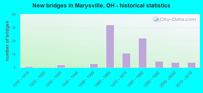
- New bridges - historical statistics
- 11910-1919
- 21930-1939
- 31950-1959
- 321960-1969
- 111970-1979
- 221980-1989
- 51990-1999
- 42000-2009
- 42010-2019

- Reconstructed bridges - Historical Statistics
- 31980-1989
- 51990-1999
- 32000-2009


- Bridge Condition - Deck
- 20.3%Excellent
- 28.8%Very good
- 42.4%Good
- 8.5%Satisfactory

- Bridge Condition - Superstructure
- 11.9%Excellent
- 37.3%Very good
- 33.9%Good
- 10.2%Satisfactory
- 5.1%Fair
- 1.7%Serious

- Bridge Condition - Substructure
- 22.0%Excellent
- 30.5%Very good
- 33.9%Good
- 8.5%Satisfactory
- 5.1%Fair

- Bridge Condition - Channel
- 5.0%Excellent
- 30.0%Very good
- 15.0%Good
- 40.0%Satisfactory
- 7.5%Fair
- 2.5%Poor

- Bridge Condition - Culverts
- 50.0%Excellent
- 25.0%Very good
- 25.0%Satisfactory
Find on map >> Show street view
Structure Number: 8031495, Location: 0.1 MI WEST of SR 38 (Lat: 40.160511, Lng: -83.394981), Route carried "on" structure: County highway T0069, Year Built: 1972, Status: Open, Structure Length: 3.11m (10.20ft), Average Daily Traffic: 454 (year 2015), Truck Traffic: 7%, Average Future Daily Traffic: 630 (year 2035), Design Load: HS 20, Features Intersected: BUCK RUN, Facility Carried by Structure: TR 69 B ORCHARD RD
Minimum Vertical Clearance: 30+ m (98+ ft), Kilometerpoint: 4.081, Lanes on structure: 2, Owner: County Highway Agency, Approaching Roadway Width: 9.8m (32.2ft), Material/Design: Concrete continuous, Design/Construction: Slab, Number Of Spans In Main Unit: 3, Length of Maximum Span: 11.6m (38.1ft), Curb-To-Curb Width: 8.5m (27.9ft), Out-to-Out Width: 8.5m (27.9ft)
Condition: Deck: Good, Superstructure: Satisfactory, Substructure: Good, Channel: Very good, Operating Rating: 29.2 metric tons, Method Used To Determine Operating Rating: Load Factor (LF) rating reported by rating factor (RF) method using MS18 loading, Inventory Rating: 19.4 metric tons, Method Used To Determine Inventory Rating: Load Factor (LF) rating reported by rating factor (RF) method using MS18 loading, Structural Evaluation: Somewhat better than minimum adequacy, Deck Geometry: Somewhat better than minimum adequacy, Waterway Adequacy: Equal to present desirable criteria, Approach Roadway Alignment: Equal to present minimum criteria, Designated Inspection Frequency: Every 12 months, Inspection Date: December 2021, Deck Structure Type: Concrete Cast-file-Place, Wearing Surface/Protective System: Wearing Surface: Monolithic Concrete
Find on map >> Show street view
Structure Number: 8031576, Location: 0.8 MI EAST of SR 4 (Lat: 40.198131, Lng: -83.399650), Route carried "on" structure: County highway T0070, Year Built: 1930, Year Reconstructed: 2001, Status: Open, Structure Length: 0.70m (2.30ft), Average Daily Traffic: 327 (year 2015), Truck Traffic: 5%, Average Future Daily Traffic: 454 (year 2035), Design Load: HS 20+Mod, Features Intersected: BRANCH BUCK RUN, Facility Carried by Structure: TR 70 A BOERGER RD
Minimum Vertical Clearance: 30+ m (98+ ft), Kilometerpoint: 1.321, Lanes on structure: 1, Owner: County Highway Agency, Approaching Roadway Width: 4.9m (16.1ft), Skew: 1 degrees, Material/Design: Prestressed concrete, Design/Construction: Box Beam or Girders - Multiple, Number Of Spans In Main Unit: 1, Length of Maximum Span: 6.7m (22.0ft), Curb-To-Curb Width: 6.7m (22.0ft), Out-to-Out Width: 6.7m (22.0ft)
Condition: Deck: Very good, Superstructure: Good, Substructure: Satisfactory, Channel: Satisfactory, Operating Rating: 42.1 metric tons, Method Used To Determine Operating Rating: Load Factor (LF) rating reported by rating factor (RF) method using MS18 loading, Inventory Rating: 32.4 metric tons, Method Used To Determine Inventory Rating: Load Factor (LF) rating reported by rating factor (RF) method using MS18 loading, Structural Evaluation: Equal to present minimum criteria, Deck Geometry: Meets minimum limits, Waterway Adequacy: Equal to present desirable criteria, Approach Roadway Alignment: Equal to present desirable criteria, Length Of Structure Improvement: 0.76m (2.49ft), Designated Inspection Frequency: Every 12 months, Inspection Date: November 2021, Bridge Improvement Cost: $32,000, Roadway Improvement Cost: $3,000, Total Project Cost: $40,000 ( Estimate for 2019), Deck Structure Type: Concrete Cast-file-Place, Wearing Surface/Protective System: Wearing Surface: Bituminous, Membrane: Preformed Fabric
Find on map >> Show street view
Structure Number: 8032033, Location: 2.5 MI WEST of SR 36 (Lat: 40.212050, Lng: -83.439439), Route carried "on" structure: County highway C0078, Year Built: 1977, Status: Open, Structure Length: 2.32m (7.61ft), Average Daily Traffic: 931 (year 2015), Truck Traffic: 1%, Average Future Daily Traffic: 1,292 (year 2035), Design Load: HS 20+Mod, Features Intersected: BUCK RUN, Facility Carried by Structure: CR 78 D COLLINS RD
Minimum Vertical Clearance: 30+ m (98+ ft), Kilometerpoint: 3.571, Lanes on structure: 2, Owner: County Highway Agency, Approaching Roadway Width: 7.9m (25.9ft), Skew: 2 degrees, Material/Design: Concrete continuous, Design/Construction: Slab, Number Of Spans In Main Unit: 3, Length of Maximum Span: 8.2m (26.9ft), Curb-To-Curb Width: 8.5m (27.9ft), Out-to-Out Width: 8.5m (27.9ft)
Condition: Deck: Good, Superstructure: Good, Substructure: Satisfactory, Channel: Good, Operating Rating: 32.4 metric tons, Method Used To Determine Operating Rating: Load Factor (LF) rating reported by rating factor (RF) method using MS18 loading, Inventory Rating: 19.4 metric tons, Method Used To Determine Inventory Rating: Load Factor (LF) rating reported by rating factor (RF) method using MS18 loading, Structural Evaluation: Somewhat better than minimum adequacy, Deck Geometry: Somewhat better than minimum adequacy, Waterway Adequacy: Equal to present desirable criteria, Approach Roadway Alignment: Equal to present desirable criteria, Designated Inspection Frequency: Every 12 months, Inspection Date: November 2021, Deck Structure Type: Concrete Cast-file-Place, Wearing Surface/Protective System: Wearing Surface: Bituminous
Find on map >> Show street view
Structure Number: 8032459, Location: 2 MI SW of SR 31 (Lat: 40.289031, Lng: -83.401361), Route carried "on" structure: County highway C0236, Year Built: 1997, Status: Open, Structure Length: 5.09m (16.70ft), Average Daily Traffic: 650 (year 2015), Truck Traffic: 8%, Average Future Daily Traffic: 902 (year 2035), Design Load: HS 20+Mod, Features Intersected: MILL CREEK, Facility Carried by Structure: C236A COTTON SLASH
Minimum Vertical Clearance: 30+ m (98+ ft), Kilometerpoint: 0.278, Lanes on structure: 2, Owner: County Highway Agency, Approaching Roadway Width: 6.7m (22.0ft), Skew: 1 degrees, Material/Design: Steel continuous, Design/Construction: Stringer/Multi-beam, Number Of Spans In Main Unit: 3, Length of Maximum Span: 19.8m (65.0ft), Curb-To-Curb Width: 8.5m (27.9ft), Out-to-Out Width: 8.5m (27.9ft)
Condition: Deck: Excellent, Superstructure: Very good, Substructure: Excellent, Channel: Very good, Operating Rating: 32.4 metric tons, Method Used To Determine Operating Rating: Load Factor (LF) rating reported by rating factor (RF) method using MS18 loading, Inventory Rating: 19.4 metric tons, Method Used To Determine Inventory Rating: Load Factor (LF) rating reported by rating factor (RF) method using MS18 loading, Structural Evaluation: Somewhat better than minimum adequacy, Deck Geometry: Somewhat better than minimum adequacy, Waterway Adequacy: Better than present minimum criteria, Approach Roadway Alignment: Equal to present minimum criteria, Designated Inspection Frequency: Every 24 months, Inspection Date: October 2021, Deck Structure Type: Concrete Cast-file-Place, Wearing Surface/Protective System: Wearing Surface: Monolithic Concrete, Deck Protection: Epoxy Coated Reinforcing
Find on map >> Show street view
Structure Number: 8032696, Location: 1.2 MI SOUTH of SR 36 (Lat: 40.247019, Lng: -83.264450), Route carried "on" structure: County highway C0107, Year Built: 1930, Year Reconstructed: 1996, Status: Open, Structure Length: 1.16m (3.81ft), Average Daily Traffic: 257 (year 2015), Truck Traffic: 7%, Average Future Daily Traffic: 357 (year 2035), Design Load: HS 20+Mod, Features Intersected: DUNS RUN BRANCH MILL CRK, Facility Carried by Structure: C107A SPRINGDALE
Minimum Vertical Clearance: 30+ m (98+ ft), Kilometerpoint: 2.274, Lanes on structure: 2, Owner: County Highway Agency, Approaching Roadway Width: 5.5m (18.0ft), Material/Design: Prestressed concrete, Design/Construction: Box Beam or Girders - Multiple, Number Of Spans In Main Unit: 2, Length of Maximum Span: 5.5m (18.0ft), Curb-To-Curb Width: 8.5m (27.9ft), Out-to-Out Width: 8.5m (27.9ft)
Condition: Deck: Excellent, Superstructure: Very good, Substructure: Satisfactory, Channel: Satisfactory, Operating Rating: 42.1 metric tons, Method Used To Determine Operating Rating: Load Factor (LF) rating reported by rating factor (RF) method using MS18 loading, Inventory Rating: 32.4 metric tons, Method Used To Determine Inventory Rating: Load Factor (LF) rating reported by rating factor (RF) method using MS18 loading, Structural Evaluation: Equal to present minimum criteria, Deck Geometry: Equal to present minimum criteria, Waterway Adequacy: Somewhat better than minimum adequacy, Approach Roadway Alignment: Equal to present minimum criteria, Designated Inspection Frequency: Every 12 months, Inspection Date: September 2021, Deck Structure Type: Concrete Cast-file-Place, Wearing Surface/Protective System: Wearing Surface: Bituminous, Membrane: Preformed Fabric
Find on map >> Show street view
Structure Number: 8032777, Location: 0.2 MI NORTH of WATKINS R (Lat: 40.236481, Lng: -83.306881), Route carried "on" structure: County highway T0109, Year Built: 1978, Year Reconstructed: 2021, Status: Open, Structure Length: 0.82m (2.69ft), Average Daily Traffic: 951 (year 2015), Truck Traffic: 1%, Average Future Daily Traffic: 1,320 (year 2035), Design Load: HL 93, Features Intersected: BRANCH MILL CREEK, Facility Carried by Structure: TR 109 JOLLY RD
Minimum Vertical Clearance: 30+ m (98+ ft), Kilometerpoint: 0.394, Lanes on structure: 2, Owner: County Highway Agency, Approaching Roadway Width: 9.8m (32.2ft), Skew: 3 degrees, Material/Design: Prestressed concrete, Design/Construction: Box Beam or Girders - Multiple, Number Of Spans In Main Unit: 1, Length of Maximum Span: 7.6m (24.9ft), Curb-To-Curb Width: 8.6m (28.2ft), Out-to-Out Width: 8.6m (28.2ft)
Condition: Deck: Excellent, Superstructure: Excellent, Substructure: Good, Channel: Satisfactory, Operating Rating: 49.9 metric tons, Method Used To Determine Operating Rating: Load and Resistance Factor Rating (LRFR) rating reported by rating factor(RF) method using HL-93 loadings, Inventory Rating: 38.2 metric tons, Method Used To Determine Inventory Rating: Load and Resistance Factor Rating (LRFR) rating reported by rating factor(RF) method using HL-93 loadings, Structural Evaluation: Better than present minimum criteria, Deck Geometry: Somewhat better than minimum adequacy, Waterway Adequacy: Equal to present minimum criteria, Approach Roadway Alignment: Somewhat better than minimum adequacy, Designated Inspection Frequency: Every 12 months, Inspection Date: September 2021, Deck Structure Type: Concrete Cast-file-Place, Wearing Surface/Protective System: Wearing Surface: Bituminous
Find on map >> Show street view
Structure Number: 8032939, Location: 0.25 NORTH of 5TH STREET (Lat: 40.243889, Lng: -83.355131), Route carried "on" structure: County highway C0114, Year Built: 1972, Year Reconstructed: 2012, Status: Open, Structure Length: 6.25m (20.51ft), Average Daily Traffic: 1,654 (year 2015), Truck Traffic: 5%, Average Future Daily Traffic: 2,296 (year 2035), Design Load: HS 20, Features Intersected: MILL CREEK, Facility Carried by Structure: CR 114 WALDO RD
Minimum Vertical Clearance: 30+ m (98+ ft), Kilometerpoint: 0.919, Lanes on structure: 2, Owner: County Highway Agency, Approaching Roadway Width: 10.4m (34.1ft), Skew: 4 degrees, Material/Design: Prestressed concrete, Design/Construction: Stringer/Multi-beam, Number Of Spans In Main Unit: 3, Length of Maximum Span: 19.5m (64.0ft), Curb-To-Curb Width: 8.5m (27.9ft), Out-to-Out Width: 8.5m (27.9ft)
Condition: Deck: Very good, Superstructure: Good, Substructure: Very good, Channel: Very good, Operating Rating: 74.5 metric tons, Method Used To Determine Operating Rating: Load Factor (LF) rating reported by rating factor (RF) method using MS18 loading, Inventory Rating: 45.4 metric tons, Method Used To Determine Inventory Rating: Load Factor (LF) rating reported by rating factor (RF) method using MS18 loading, Structural Evaluation: Better than present minimum criteria, Deck Geometry: Somewhat better than minimum adequacy, Waterway Adequacy: Equal to present desirable criteria, Approach Roadway Alignment: Equal to present desirable criteria, Designated Inspection Frequency: Every 24 months, Underwater Inspection Frequency: Every 60 months, Inspection Date: September 2021, Underwater Inspection Date: May 2020, Deck Structure Type: Concrete Cast-file-Place, Wearing Surface/Protective System: Wearing Surface: Latex Concrete
Find on map >> Show street view
Structure Number: 8033153, Location: 1.5 MI SOUTH of SR 347 (Lat: 40.329369, Lng: -83.355619), Route carried "on" structure: County highway C0129, Year Built: 1969, Status: Open, Structure Length: 1.52m (4.99ft), Average Daily Traffic: 1,102 (year 2015), Truck Traffic: 7%, Average Future Daily Traffic: 1,530 (year 2035), Design Load: HS 20+Mod, Features Intersected: BLUES CREEK, Facility Carried by Structure: C129E WOLFORD MASK
Minimum Vertical Clearance: 30+ m (98+ ft), Kilometerpoint: 5.211, Lanes on structure: 2, Owner: County Highway Agency, Approaching Roadway Width: 8.5m (27.9ft), Skew: 2 degrees, Material/Design: Prestressed concrete, Design/Construction: Box Beam or Girders - Multiple, Number Of Spans In Main Unit: 1, Length of Maximum Span: 14.0m (45.9ft), Curb-To-Curb Width: 7.4m (24.3ft), Out-to-Out Width: 7.4m (24.3ft)
Condition: Deck: Good, Superstructure: Good, Substructure: Good, Channel: Fair, Operating Rating: 19.4 metric tons, Method Used To Determine Operating Rating: Load Factor (LF) rating reported by rating factor (RF) method using MS18 loading, Inventory Rating: 13.0 metric tons, Method Used To Determine Inventory Rating: Load Factor (LF) rating reported by rating factor (RF) method using MS18 loading, Structural Evaluation: Meets minimum limits, Deck Geometry: Meets minimum limits, Waterway Adequacy: Somewhat better than minimum adequacy, Approach Roadway Alignment: Somewhat better than minimum adequacy, Designated Inspection Frequency: Every 24 months, Inspection Date: September 2021, Deck Structure Type: Concrete Cast-file-Place, Wearing Surface/Protective System: Wearing Surface: Bituminous
Find on map >> Show street view
Structure Number: 8033269, Location: 0.1 MI SOUTH OF CR 104 (Lat: 40.210661, Lng: -83.267561), Route carried "on" structure: County highway C0036, Year Built: 1998, Status: Open, Structure Length: 1.31m (4.30ft), Average Daily Traffic: 204 (year 2015), Truck Traffic: 7%, Average Future Daily Traffic: 283 (year 2035), Design Load: HS 20+Mod, Features Intersected: BRANCH OF MILL CREEK, Facility Carried by Structure: C36B BEECHER-GMBL
Minimum Vertical Clearance: 30+ m (98+ ft), Kilometerpoint: 4.300, Lanes on structure: 2, Owner: County Highway Agency, Approaching Roadway Width: 6.1m (20.0ft), Material/Design: Prestressed concrete, Design/Construction: Box Beam or Girders - Multiple, Number Of Spans In Main Unit: 1, Length of Maximum Span: 12.8m (42.0ft), Curb-To-Curb Width: 7.3m (24.0ft), Out-to-Out Width: 7.3m (24.0ft)
Condition: Deck: Satisfactory, Superstructure: Satisfactory, Substructure: Excellent, Channel: Satisfactory, Operating Rating: 42.1 metric tons, Method Used To Determine Operating Rating: Load Factor (LF) rating reported by rating factor (RF) method using MS18 loading, Inventory Rating: 29.2 metric tons, Method Used To Determine Inventory Rating: Load Factor (LF) rating reported by rating factor (RF) method using MS18 loading, Structural Evaluation: Equal to present minimum criteria, Deck Geometry: Somewhat better than minimum adequacy, Waterway Adequacy: Equal to present desirable criteria, Approach Roadway Alignment: Equal to present minimum criteria, Designated Inspection Frequency: Every 12 months, Inspection Date: October 2021, Deck Structure Type: Concrete Cast-file-Place, Wearing Surface/Protective System: Wearing Surface: Bituminous, Membrane: Preformed Fabric
Find on map >> Show street view
Structure Number: 8033587, Location: 1.5 MI EAST of SR 36 (Lat: 40.247961, Lng: -83.266411), Route carried "on" structure: County highway C0135, Year Built: 1976, Status: Open, Structure Length: 0.98m (3.22ft), Average Daily Traffic: 160 (year 2015), Truck Traffic: 8%, Average Future Daily Traffic: 222 (year 2035), Design Load: HS 20+Mod, Features Intersected: DUNS RUN BRANCH MILL CRK, Facility Carried by Structure: C135A DOVER-COUNTY
Minimum Vertical Clearance: 30+ m (98+ ft), Kilometerpoint: 2.361, Lanes on structure: 2, Owner: County Highway Agency, Approaching Roadway Width: 8.5m (27.9ft), Material/Design: Prestressed concrete, Design/Construction: Box Beam or Girders - Multiple, Number Of Spans In Main Unit: 1, Length of Maximum Span: 9.4m (30.8ft), Curb-To-Curb Width: 8.5m (27.9ft), Out-to-Out Width: 8.5m (27.9ft)
Condition: Deck: Good, Superstructure: Good, Substructure: Good, Channel: Good, Operating Rating: 42.1 metric tons, Method Used To Determine Operating Rating: Load Factor (LF) rating reported by rating factor (RF) method using MS18 loading, Inventory Rating: 32.4 metric tons, Method Used To Determine Inventory Rating: Load Factor (LF) rating reported by rating factor (RF) method using MS18 loading, Structural Evaluation: Better than present minimum criteria, Deck Geometry: Equal to present minimum criteria, Waterway Adequacy: Equal to present minimum criteria, Approach Roadway Alignment: Better than present minimum criteria, Designated Inspection Frequency: Every 24 months, Inspection Date: September 2021, Deck Structure Type: Concrete Cast-file-Place, Wearing Surface/Protective System: Wearing Surface: Bituminous
Find on map >> Show street view
Structure Number: 8033668, Location: 2.4 MI NORTH of RAYMOND R (Lat: 40.278419, Lng: -83.420450), Route carried "on" structure: County highway C0136, Year Built: 1972, Status: Open, Structure Length: 1.83m (6.00ft), Average Daily Traffic: 143 (year 2015), Truck Traffic: 7%, Average Future Daily Traffic: 198 (year 2035), Design Load: HS 20+Mod, Features Intersected: OTTER RUN, Facility Carried by Structure: C136D DOG LEG RD
Minimum Vertical Clearance: 30+ m (98+ ft), Kilometerpoint: 3.861, Lanes on structure: 2, Owner: County Highway Agency, Approaching Roadway Width: 9.8m (32.2ft), Material/Design: Prestressed concrete, Design/Construction: Box Beam or Girders - Multiple, Number Of Spans In Main Unit: 2, Length of Maximum Span: 9.1m (29.9ft), Curb-To-Curb Width: 8.6m (28.2ft), Out-to-Out Width: 8.6m (28.2ft)
Condition: Deck: Good, Superstructure: Good, Substructure: Fair, Channel: Satisfactory, Operating Rating: 42.1 metric tons, Method Used To Determine Operating Rating: Load Factor (LF) rating reported by rating factor (RF) method using MS18 loading, Inventory Rating: 32.4 metric tons, Method Used To Determine Inventory Rating: Load Factor (LF) rating reported by rating factor (RF) method using MS18 loading, Structural Evaluation: Somewhat better than minimum adequacy, Deck Geometry: Equal to present minimum criteria, Waterway Adequacy: Equal to present desirable criteria, Approach Roadway Alignment: Meets minimum limits, Designated Inspection Frequency: Every 12 months, Inspection Date: October 2021, Deck Structure Type: Concrete Cast-file-Place, Wearing Surface/Protective System: Wearing Surface: Bituminous
Find on map >> Show street view
Structure Number: 8034206, Location: 0.25MI N OF CR128 (Lat: 40.293919, Lng: -83.312561), Route carried "on" structure: County highway C0194, Year Built: 2013, Status: Open, Structure Length: 2.01m (6.59ft), Average Daily Traffic: 175 (year 2015), Truck Traffic: 7%, Average Future Daily Traffic: 243 (year 2035), Design Load: HS 25 or greater, Features Intersected: BLUES CREEK, Facility Carried by Structure: C194A LEEPER-PERKN
Minimum Vertical Clearance: 30+ m (98+ ft), Kilometerpoint: 1.658, Lanes on structure: 2, Owner: County Highway Agency, Approaching Roadway Width: 5.5m (18.0ft), Material/Design: Prestressed concrete, Design/Construction: Box Beam or Girders - Multiple, Number Of Spans In Main Unit: 1, Length of Maximum Span: 19.8m (65.0ft), Curb-To-Curb Width: 7.3m (24.0ft), Out-to-Out Width: 8.5m (27.9ft)
Condition: Deck: Excellent, Superstructure: Excellent, Substructure: Excellent, Channel: Excellent, Operating Rating: 48.6 metric tons, Method Used To Determine Operating Rating: Load and Resistance Factor Rating (LRFR) rating reported by rating factor(RF) method using HL-93 loadings, Inventory Rating: 35.6 metric tons, Method Used To Determine Inventory Rating: Load and Resistance Factor Rating (LRFR) rating reported by rating factor(RF) method using HL-93 loadings, Structural Evaluation: Superior to present desirable criteria, Deck Geometry: Somewhat better than minimum adequacy, Waterway Adequacy: Superior to present desirable criteria, Approach Roadway Alignment: Equal to present desirable criteria, Designated Inspection Frequency: Every 24 months, Inspection Date: December 2021, Deck Structure Type: Concrete Cast-file-Place, Wearing Surface/Protective System: Wearing Surface: Bituminous, Membrane: Preformed Fabric, Deck Protection: Epoxy Coated Reinforcing
Find on map >> Show street view
Structure Number: 8034338, Location: 0.1 MI EAST of CR 113 (Lat: 40.284361, Lng: -83.295911), Route carried "on" structure: County highway C0194, Year Built: 1971, Status: Open, Structure Length: 1.98m (6.50ft), Average Daily Traffic: 709 (year 2015), Truck Traffic: 7%, Average Future Daily Traffic: 984 (year 2035), Design Load: HS 20+Mod, Features Intersected: BLUES CREEK, Facility Carried by Structure: C194D LEEPER-PERKN
Minimum Vertical Clearance: 30+ m (98+ ft), Kilometerpoint: 3.710, Lanes on structure: 2, Owner: County Highway Agency, Approaching Roadway Width: 9.1m (29.9ft), Material/Design: Prestressed concrete, Design/Construction: Box Beam or Girders - Multiple, Number Of Spans In Main Unit: 2, Length of Maximum Span: 9.4m (30.8ft), Curb-To-Curb Width: 8.6m (28.2ft), Out-to-Out Width: 8.6m (28.2ft)
Condition: Deck: Satisfactory, Superstructure: Fair, Substructure: Satisfactory, Channel: Satisfactory, Operating Rating: 42.1 metric tons, Method Used To Determine Operating Rating: Load Factor (LF) rating reported by rating factor (RF) method using MS18 loading, Inventory Rating: 32.4 metric tons, Method Used To Determine Inventory Rating: Load Factor (LF) rating reported by rating factor (RF) method using MS18 loading, Structural Evaluation: Somewhat better than minimum adequacy, Deck Geometry: Somewhat better than minimum adequacy, Waterway Adequacy: Equal to present desirable criteria, Approach Roadway Alignment: Equal to present desirable criteria, Designated Inspection Frequency: Every 12 months, Inspection Date: September 2021, Deck Structure Type: Concrete Cast-file-Place, Wearing Surface/Protective System: Wearing Surface: Bituminous
Find on map >> Show street view
Structure Number: 8034494, Location: 0.1 MI WEST of SR 4 (Lat: 40.306500, Lng: -83.333700), Route carried "on" structure: County highway C0196, Year Built: 1970, Status: Open, Structure Length: 1.59m (5.22ft), Average Daily Traffic: 126 (year 2015), Truck Traffic: 8%, Average Future Daily Traffic: 175 (year 2035), Design Load: HS 20+Mod, Features Intersected: BLUES CREEK, Facility Carried by Structure: C196B MACKLIN RD
Minimum Vertical Clearance: 30+ m (98+ ft), Kilometerpoint: 1.587, Lanes on structure: 2, Owner: County Highway Agency, Approaching Roadway Width: 9.8m (32.2ft), Material/Design: Prestressed concrete, Design/Construction: Box Beam or Girders - Multiple, Number Of Spans In Main Unit: 1, Length of Maximum Span: 15.5m (50.9ft), Curb-To-Curb Width: 8.6m (28.2ft), Out-to-Out Width: 8.6m (28.2ft)
Condition: Deck: Very good, Superstructure: Very good, Substructure: Good, Channel: Satisfactory, Operating Rating: 42.1 metric tons, Method Used To Determine Operating Rating: Load Factor (LF) rating reported by rating factor (RF) method using MS18 loading, Inventory Rating: 25.9 metric tons, Method Used To Determine Inventory Rating: Load Factor (LF) rating reported by rating factor (RF) method using MS18 loading, Structural Evaluation: Equal to present minimum criteria, Deck Geometry: Equal to present minimum criteria, Waterway Adequacy: Equal to present desirable criteria, Approach Roadway Alignment: Equal to present desirable criteria, Designated Inspection Frequency: Every 24 months, Inspection Date: September 2021, Deck Structure Type: Other, Wearing Surface/Protective System: Wearing Surface: Bituminous
Find on map >> Show street view
Structure Number: 8039187, Location: 4.5MI WEST of SR 42 (Lat: 40.212369, Lng: -83.264219), Route carried "on" structure: County highway C0104, Year Built: 2017, Status: Open, Structure Length: 1.19m (3.90ft), Average Daily Traffic: 3,536 (year 2016), Truck Traffic: 6%, Average Future Daily Traffic: 4,713 (year 2036), Design Load: HL 93, Features Intersected: BRANCH OF MILL CREEK, Facility Carried by Structure: CR 104 F WATKINS R
Minimum Vertical Clearance: 30+ m (98+ ft), Kilometerpoint: 8.774, Lanes on structure: 2, Owner: County Highway Agency, Approaching Roadway Width: 7.3m (24.0ft), Material/Design: Concrete, Design/Construction: Slab, Number Of Spans In Main Unit: 1, Length of Maximum Span: 11.6m (38.1ft), Curb-To-Curb Width: 11.0m (36.1ft), Out-to-Out Width: 11.0m (36.1ft)
Condition: Deck: Excellent, Superstructure: Excellent, Substructure: Excellent, Channel: Very good, Operating Rating: 61.6 metric tons, Method Used To Determine Operating Rating: Load and Resistance Factor Rating (LRFR) rating reported by rating factor(RF) method using HL-93 loadings, Inventory Rating: 48.6 metric tons, Method Used To Determine Inventory Rating: Load and Resistance Factor Rating (LRFR) rating reported by rating factor(RF) method using HL-93 loadings, Structural Evaluation: Superior to present desirable criteria, Deck Geometry: Somewhat better than minimum adequacy, Waterway Adequacy: Superior to present desirable criteria, Approach Roadway Alignment: Equal to present desirable criteria, Designated Inspection Frequency: Every 24 months, Inspection Date: October 2021, Deck Structure Type: Concrete Cast-file-Place, Wearing Surface/Protective System: Wearing Surface: Monolithic Concrete, Deck Protection: Epoxy Coated Reinforcing
Find on map >> Show street view
Structure Number: 8047669, Location: 2.6 MI NW of SR 42 (Lat: 40.180289, Lng: -83.273150), Route carried "on" structure: County highway C0001, Year Built: 1985, Status: Open, Structure Length: 1.10m (3.61ft), Average Daily Traffic: 5,820 (year 2015), Truck Traffic: 7%, Average Future Daily Traffic: 8,078 (year 2035), Design Load: HS 20+Mod, Features Intersected: LEO RAUSCH SUGAR RUN, Facility Carried by Structure: C1G INDUSTRIAL PKW
Minimum Vertical Clearance: 30+ m (98+ ft), Kilometerpoint: 9.400, Lanes on structure: 2, Owner: County Highway Agency, Approaching Roadway Width: 8.5m (27.9ft), Material/Design: Prestressed concrete, Design/Construction: Box Beam or Girders - Multiple, Number Of Spans In Main Unit: 1, Length of Maximum Span: 10.1m (33.1ft), Curb-To-Curb Width: 11.1m (36.4ft), Out-to-Out Width: 11.1m (36.4ft)
Condition: Deck: Very good, Superstructure: Very good, Substructure: Very good, Channel: Satisfactory, Operating Rating: 42.1 metric tons, Method Used To Determine Operating Rating: Load Factor (LF) rating reported by rating factor (RF) method using MS18 loading, Inventory Rating: 32.4 metric tons, Method Used To Determine Inventory Rating: Load Factor (LF) rating reported by rating factor (RF) method using MS18 loading, Structural Evaluation: Equal to present desirable criteria, Deck Geometry: Meets minimum limits, Waterway Adequacy: Equal to present minimum criteria, Approach Roadway Alignment: Equal to present desirable criteria, Designated Inspection Frequency: Every 24 months, Inspection Date: November 2021, Deck Structure Type: Concrete Cast-file-Place, Wearing Surface/Protective System: Wearing Surface: Bituminous
Find on map >> Show street view
Structure Number: 8047863, Location: 0.1 NORTH of SCOTTSLAWN (Lat: 40.207300, Lng: -83.314389), Route carried "on" structure: County highway C0001, Year Built: 1985, Year Reconstructed: 1998, Status: Open, Structure Length: 1.28m (4.20ft), Average Daily Traffic: 4,071 (year 2015), Truck Traffic: 5%, Average Future Daily Traffic: 5,651 (year 2035), Design Load: HS 20+Mod, Features Intersected: GILCRIST RUN, Facility Carried by Structure: C 1 INDUSTRIAL PKW
Minimum Vertical Clearance: 30+ m (98+ ft), Kilometerpoint: 4.786, Lanes on structure: 2, Owner: County Highway Agency, Approaching Roadway Width: 13.1m (43.0ft), Material/Design: Prestressed concrete, Design/Construction: Box Beam or Girders - Multiple, Number Of Spans In Main Unit: 1, Length of Maximum Span: 12.5m (41.0ft), Curb-To-Curb Width: 13.4m (44.0ft), Out-to-Out Width: 13.4m (44.0ft)
Condition: Deck: Good, Superstructure: Very good, Substructure: Good, Channel: Satisfactory, Operating Rating: 42.1 metric tons, Method Used To Determine Operating Rating: Load Factor (LF) rating reported by rating factor (RF) method using MS18 loading, Inventory Rating: 32.4 metric tons, Method Used To Determine Inventory Rating: Load Factor (LF) rating reported by rating factor (RF) method using MS18 loading, Structural Evaluation: Better than present minimum criteria, Deck Geometry: Better than present minimum criteria, Waterway Adequacy: Equal to present minimum criteria, Approach Roadway Alignment: Equal to present desirable criteria, Designated Inspection Frequency: Every 24 months, Inspection Date: November 2021, Deck Structure Type: Concrete Cast-file-Place, Wearing Surface/Protective System: Wearing Surface: Bituminous
Find on map >> Show street view
Structure Number: 8050821, Location: 2 MI NORTH of MARYSVILLE (Lat: 40.279200, Lng: -83.398781), Route carried "on" structure: County highway C0191, Year Built: 1979, Status: Open, Structure Length: 2.01m (6.59ft), Average Daily Traffic: 1,367 (year 2015), Truck Traffic: 7%, Average Future Daily Traffic: 1,897 (year 2035), Design Load: HS 20+Mod, Features Intersected: OTTER RUN, Facility Carried by Structure: C191I RAYMOND RD
Minimum Vertical Clearance: 30+ m (98+ ft), Kilometerpoint: 8.225, Lanes on structure: 2, Owner: County Highway Agency, Approaching Roadway Width: 9.8m (32.2ft), Skew: 1 degrees, Material/Design: Concrete continuous, Design/Construction: Slab, Number Of Spans In Main Unit: 3, Length of Maximum Span: 7.3m (24.0ft), Curb-To-Curb Width: 8.5m (27.9ft), Out-to-Out Width: 9.1m (29.9ft)
Condition: Deck: Good, Superstructure: Good, Substructure: Good, Channel: Satisfactory, Operating Rating: 29.2 metric tons, Method Used To Determine Operating Rating: Load Factor (LF) rating reported by rating factor (RF) method using MS18 loading, Inventory Rating: 19.4 metric tons, Method Used To Determine Inventory Rating: Load Factor (LF) rating reported by rating factor (RF) method using MS18 loading, Structural Evaluation: Somewhat better than minimum adequacy, Deck Geometry: Somewhat better than minimum adequacy, Waterway Adequacy: Equal to present desirable criteria, Approach Roadway Alignment: Equal to present desirable criteria, Designated Inspection Frequency: Every 24 months, Inspection Date: November 2021, Deck Structure Type: Concrete Cast-file-Place, Wearing Surface/Protective System: Wearing Surface: Bituminous
Find on map >> Show street view
Structure Number: 8051054, Location: 0.25MI N of LEEPER-PERKIN (Lat: 40.286281, Lng: -83.298069), Route carried "on" structure: County highway C0113, Year Built: 2000, Status: Open, Structure Length: 2.80m (9.19ft), Average Daily Traffic: 460 (year 2015), Truck Traffic: 7%, Average Future Daily Traffic: 638 (year 2035), Design Load: HS 20+Mod, Features Intersected: BLUES CREEK, Facility Carried by Structure: CR113D WHITESTONE
Minimum Vertical Clearance: 30+ m (98+ ft), Kilometerpoint: 4.168, Lanes on structure: 2, Owner: County Highway Agency, Approaching Roadway Width: 5.5m (18.0ft), Material/Design: Steel, Design/Construction: Truss - Thru, Number Of Spans In Main Unit: 1, Length of Maximum Span: 27.7m (90.9ft), Curb-To-Curb Width: 8.5m (27.9ft), Out-to-Out Width: 8.7m (28.5ft)
Condition: Deck: Satisfactory, Superstructure: Satisfactory, Substructure: Good, Channel: Satisfactory, Operating Rating: 61.6 metric tons, Method Used To Determine Operating Rating: Allowable Stress (AS) rating reported by rating factor (RF) method using MS18 loading, Inventory Rating: 35.6 metric tons, Method Used To Determine Inventory Rating: Allowable Stress (AS) rating reported by rating factor (RF) method using MS18 loading, Structural Evaluation: Equal to present minimum criteria, Deck Geometry: Somewhat better than minimum adequacy, Waterway Adequacy: Superior to present desirable criteria, Approach Roadway Alignment: Equal to present desirable criteria, Designated Inspection Frequency: Every 12 months, Critical Feature Inspection Frequency: Every 24 months, Inspection Date: December 2021, Critical Feature Inspection Date: October 2020, Deck Structure Type: Wood or Timber, Wearing Surface/Protective System: Wearing Surface: Bituminous, Membrane: Preformed Fabric
Find on map >> Show street view
Structure Number: 805267, Location: 2.7 MI NORTH of SR 4 (Lat: 40.323011, Lng: -83.354261), Route carried "on" structure: County highway C0129, Year Built: 1976, Status: Open, Structure Length: 1.98m (6.50ft), Average Daily Traffic: 1,102 (year 2015), Truck Traffic: 7%, Average Future Daily Traffic: 1,530 (year 2035), Design Load: HS 20+Mod, Features Intersected: BLUES CREEK, Facility Carried by Structure: C129D WOLFRD MSKIL
Minimum Vertical Clearance: 30+ m (98+ ft), Kilometerpoint: 4.458, Lanes on structure: 2, Owner: County Highway Agency, Approaching Roadway Width: 9.8m (32.2ft), Material/Design: Concrete continuous, Design/Construction: Slab, Number Of Spans In Main Unit: 3, Length of Maximum Span: 6.4m (21.0ft), Curb-To-Curb Width: 8.5m (27.9ft), Out-to-Out Width: 8.5m (27.9ft)
Condition: Deck: Good, Superstructure: Satisfactory, Substructure: Very good, Channel: Good, Operating Rating: 29.2 metric tons, Method Used To Determine Operating Rating: Load Factor (LF) rating reported by rating factor (RF) method using MS18 loading, Inventory Rating: 19.4 metric tons, Method Used To Determine Inventory Rating: Load Factor (LF) rating reported by rating factor (RF) method using MS18 loading, Structural Evaluation: Somewhat better than minimum adequacy, Deck Geometry: Somewhat better than minimum adequacy, Waterway Adequacy: Equal to present desirable criteria, Approach Roadway Alignment: Equal to present desirable criteria, Designated Inspection Frequency: Every 12 months, Inspection Date: August 2021, Deck Structure Type: Concrete Cast-file-Place, Wearing Surface/Protective System: Wearing Surface: Bituminous
Find on map >> Show street view
Structure Number: 8060223, Location: 0.1MILE NORTH OF RAILROAD (Lat: 40.242489, Lng: -83.371839), Route carried "on" structure: County highway MAPLE, Year Built: 1968, Year Reconstructed: 2012, Status: Open, Structure Length: 4.34m (14.24ft), Average Daily Traffic: 4,756 (year 2015), Truck Traffic: 5%, Average Future Daily Traffic: 6,601 (year 2035), Design Load: HS 20+Mod, Features Intersected: MILL CREEK
Minimum Vertical Clearance: 30+ m (98+ ft), Kilometerpoint: 0.644, Lanes on structure: 2, Owner: City or Municipal Highway Agency, Approaching Roadway Width: 8.5m (27.9ft), Material/Design: Prestressed concrete, Design/Construction: Box Beam or Girders - Multiple, Number Of Spans In Main Unit: 3, Length of Maximum Span: 14.3m (46.9ft), Curb or Sidewalk Widths: Left: 1.5m (4.9ft), Right: 0.0m, Curb-To-Curb Width: 9.0m (29.5ft), Out-to-Out Width: 11.0m (36.1ft)
Condition: Deck: Good, Superstructure: Good, Substructure: Good, Channel: Good, Operating Rating: 61.6 metric tons, Method Used To Determine Operating Rating: Load Factor (LF) rating reported by rating factor (RF) method using MS18 loading, Inventory Rating: 35.6 metric tons, Method Used To Determine Inventory Rating: Load Factor (LF) rating reported by rating factor (RF) method using MS18 loading, Structural Evaluation: Better than present minimum criteria, Deck Geometry: Meets minimum limits, Waterway Adequacy: Equal to present desirable criteria, Approach Roadway Alignment: Equal to present desirable criteria, Designated Inspection Frequency: Every 24 months, Inspection Date: October 2021, Deck Structure Type: Other, Wearing Surface/Protective System: Wearing Surface: Bituminous
Find on map >> Show street view
Structure Number: 8061173, Location: 0.2 MI. E. OF S.R. 4 (Lat: 40.258661, Lng: -83.361839), Route carried "on" structure: City street SCOTT, Year Built: 2001, Status: Open, Structure Length: 2.87m (9.42ft), Average Daily Traffic: 1,500 (year 2010), Truck Traffic: 2%, Average Future Daily Traffic: 2,082 (year 2030), Design Load: HS 20+Mod, Features Intersected: INFIRMARY DITCH
Minimum Vertical Clearance: 30+ m (98+ ft), Kilometerpoint: 0.354, Lanes on structure: 2, Owner: City or Municipal Highway Agency, Approaching Roadway Width: 9.8m (32.2ft), Skew: 1 degrees, Material/Design: Prestressed concrete, Design/Construction: Box Beam or Girders - Multiple, Number Of Spans In Main Unit: 1, Length of Maximum Span: 28.0m (91.9ft), Curb or Sidewalk Widths: Left: 0.0m, Right: 2.4m (7.9ft), Curb-To-Curb Width: 9.8m (32.2ft), Out-to-Out Width: 12.2m (40.0ft)
Condition: Deck: Good, Superstructure: Good, Substructure: Good, Channel: Satisfactory, Operating Rating: 68.0 metric tons, Method Used To Determine Operating Rating: Load Factor (LF) rating reported by rating factor (RF) method using MS18 loading, Inventory Rating: 38.9 metric tons, Method Used To Determine Inventory Rating: Load Factor (LF) rating reported by rating factor (RF) method using MS18 loading, Structural Evaluation: Better than present minimum criteria, Deck Geometry: Somewhat better than minimum adequacy, Waterway Adequacy: Better than present minimum criteria, Approach Roadway Alignment: Equal to present desirable criteria, Designated Inspection Frequency: Every 24 months, Inspection Date: October 2021, Deck Structure Type: Other, Wearing Surface/Protective System: Wearing Surface: Bituminous
Find on map >> Show street view
Structure Number: 8062064, Location: 0.3 MI. N. OF C.R.1 (Lat: 40.228411, Lng: -83.339300), Route carried "on" structure: City street COLEM, Year Built: 2005, Status: Open, Structure Length: 0.90m (2.95ft), Average Daily Traffic: 5,000 (year 2010), Truck Traffic: 5%, Average Future Daily Traffic: 6,940 (year 2030), Design Load: HS 20, Features Intersected: BEACH DITCH (SOUTH)
Minimum Vertical Clearance: 30+ m (98+ ft), Kilometerpoint: 0.483, Lanes on structure: 2, Owner: City or Municipal Highway Agency, Approaching Roadway Width: 29.0m (95.1ft), Skew: 25 degrees, Material/Design: Concrete, Design/Construction: Frame, Number Of Spans In Main Unit: 1, Length of Maximum Span: 7.8m (25.6ft), Curb or Sidewalk Widths: Left: 0.0m, Right: 1.2m (3.9ft), Curb-To-Curb Width: 11.0m (36.1ft), Out-to-Out Width: 15.2m (49.9ft)
Condition: Deck: Very good, Superstructure: Very good, Substructure: Very good, Channel: Satisfactory, Operating Rating: 42.1 metric tons, Method Used To Determine Operating Rating: Load and Resistance Factor Rating (LRFR) rating reported by rating factor(RF) method using HL-93 loadings, Inventory Rating: 32.4 metric tons, Method Used To Determine Inventory Rating: Load and Resistance Factor Rating (LRFR) rating reported by rating factor(RF) method using HL-93 loadings, Structural Evaluation: Equal to present desirable criteria, Deck Geometry: Somewhat better than minimum adequacy, Waterway Adequacy: Better than present minimum criteria, Approach Roadway Alignment: Equal to present desirable criteria, Designated Inspection Frequency: Every 24 months, Inspection Date: October 2021, Deck Structure Type: Concrete Cast-file-Place, Wearing Surface/Protective System: Wearing Surface: Bituminous
Find on map >> Show street view
Structure Number: 8000093, Location: .33 MI EAST SR31 (Lat: 40.253019, Lng: -83.367150), Route carried "under" structure: US 33, Year Built: 1967, Structure Length: 0. m, Average Daily Traffic: 35,111 (year 2015), Truck Traffic: 10%, Features Intersected: UNDER SR-4, Facility Carried by Structure: SR-4
Minimum Vertical Clearance: 5.18m (16.99ft), Kilometerpoint: 17.188, Lanes on structure: 4, Lanes under structure: 4, Material/Design: Steel continuous, Design/Construction: Stringer/Multi-beam, Length of Maximum Span: 22.2m (72.8ft)
Find on map >> Show street view
Structure Number: 8000395, Location: .33 MI WEST OF SR4 (Lat: 40.253981, Lng: -83.373169), Route carried "under" structure: US 33, Year Built: 1967, Structure Length: 0. m, Average Daily Traffic: 35,111 (year 2015), Truck Traffic: 10%, Features Intersected: UNDER SR-31, Facility Carried by Structure: SR 31
Minimum Vertical Clearance: 5.36m (17.59ft), Kilometerpoint: 16.657, Lanes on structure: 4, Lanes under structure: 4, Material/Design: Steel continuous, Design/Construction: Stringer/Multi-beam, Length of Maximum Span: 29.9m (98.1ft)
Find on map >> Show street view
Structure Number: 8000786, Location: OVER NW PKWY (Lat: 40.243119, Lng: -83.398319), Route carried "under" structure: State highway 245, Year Built: 1966, Structure Length: 0. m, Average Daily Traffic: 9,659 (year 2015), Truck Traffic: 3%, Features Intersected: US33, Facility Carried by Structure: US 33
Minimum Vertical Clearance: 5.44m (17.85ft), Kilometerpoint: 11.941, Lanes on structure: 2, Lanes under structure: 4, Material/Design: Concrete continuous, Design/Construction: Slab, Length of Maximum Span: 13.7m (44.9ft)
Find on map >> Show street view
Structure Number: 8000816, Location: OVER NW PKWY (Lat: 40.243039, Lng: -83.398039), Route carried "under" structure: State highway 245, Year Built: 1966, Structure Length: 0. m, Average Daily Traffic: 9,659 (year 2015), Truck Traffic: 3%, Features Intersected: US33, Facility Carried by Structure: US 33
Minimum Vertical Clearance: 4.52m (14.83ft), Kilometerpoint: 11.957, Lanes on structure: 2, Lanes under structure: 4, Material/Design: Concrete continuous, Design/Construction: Slab, Length of Maximum Span: 13.7m (44.9ft)
Find on map >> Show street view
Structure Number: 8000832, Location: 4.25 MI N OF SR739 (Lat: 40.256781, Lng: -83.456319), Route carried "under" structure: US 33, Year Built: 1987, Structure Length: 0. m, Average Daily Traffic: 30,970 (year 2015), Truck Traffic: 13%, Features Intersected: UNDER POLING ROAD (TR151, Facility Carried by Structure: POLING RD (TR 151)
Minimum Vertical Clearance: 5.69m (18.67ft), Kilometerpoint: 8.127, Lanes on structure: 2, Lanes under structure: 4, Material/Design: Steel continuous, Design/Construction: Stringer/Multi-beam, Length of Maximum Span: 42.1m (138.1ft)
Find on map >> Show street view
Structure Number: 8000905, Location: 0.92 MI N OF SR245 (Lat: 40.246719, Lng: -83.394239), Route carried "under" structure: County highway 191, Year Built: 1966, Structure Length: 0. m, Average Daily Traffic: 2,520 (year 2015), Truck Traffic: 5%, Features Intersected: UNDER US 33-0893L, Facility Carried by Structure: US 33
Minimum Vertical Clearance: 6.43m (21.10ft), Kilometerpoint: 0.789, Lanes on structure: 2, Lanes under structure: 2, Material/Design: Steel continuous, Design/Construction: Stringer/Multi-beam, Length of Maximum Span: 14.6m (47.9ft)
Find on map >> Show street view
Structure Number: 8000964, Location: 0.92 MI N. OF SR245 (Lat: 40.246539, Lng: -83.394089), Route carried "under" structure: County highway 191, Year Built: 1966, Structure Length: 0. m, Average Daily Traffic: 2,520 (year 2015), Truck Traffic: 5%, Features Intersected: UNDER US 33-0893R, Facility Carried by Structure: US 33
Minimum Vertical Clearance: 6.35m (20.83ft), Kilometerpoint: 0.772, Lanes on structure: 2, Lanes under structure: 2, Material/Design: Steel continuous, Design/Construction: Stringer/Multi-beam, Length of Maximum Span: 14.6m (47.9ft)
Find on map >> Show street view
Structure Number: 8001006, Location: 5.3 MI N OF SR739 (Lat: 40.252600, Lng: -83.440889), Route carried "under" structure: County highway CO134, Year Built: 1987, Structure Length: 0. m, Average Daily Traffic: 292 (year 2015), Truck Traffic: 8%, Features Intersected: US33, Facility Carried by Structure: US 33
Minimum Vertical Clearance: 4.55m (14.93ft), Kilometerpoint: 1.529, Lanes on structure: 2, Lanes under structure: 2, Material/Design: Prestressed concrete, Design/Construction: Box Beam or Girders - Multiple, Length of Maximum Span: 12.2m (40.0ft)
Find on map >> Show street view
Structure Number: 8001014, Location: 5.13 MI N OF SR739 (Lat: 40.252411, Lng: -83.440950), Route carried "under" structure: County highway C0134, Year Built: 1987, Structure Length: 0. m, Average Daily Traffic: 292 (year 2015), Truck Traffic: 8%, Features Intersected: US33, Facility Carried by Structure: US 33
Minimum Vertical Clearance: 4.55m (14.93ft), Kilometerpoint: 1.513, Lanes on structure: 2, Lanes under structure: 2, Material/Design: Prestressed concrete, Design/Construction: Box Beam or Girders - Multiple, Length of Maximum Span: 12.2m (40.0ft)
Find on map >> Show street view
Structure Number: 8001057, Location: 1.01 MI N OF SR4 (Lat: 40.246189, Lng: -83.355339), Route carried "under" structure: County highway 114, Year Built: 1966, Structure Length: 0. m, Average Daily Traffic: 1,654 (year 2015), Truck Traffic: 5%, Features Intersected: US 33, Facility Carried by Structure: US 33
Minimum Vertical Clearance: 4.83m (15.85ft), Kilometerpoint: 0.000, Lanes on structure: 2, Lanes under structure: 2, Material/Design: Steel continuous, Design/Construction: Stringer/Multi-beam, Length of Maximum Span: 16.8m (55.1ft)
Find on map >> Show street view
Structure Number: 8001065, Location: 7.05 MI N OF SR739 (Lat: 40.238750, Lng: -83.409481), Route carried "under" structure: State highway 245, Year Built: 1988, Structure Length: 0. m, Average Daily Traffic: 3,590 (year 2015), Truck Traffic: 2%, Features Intersected: US33, Facility Carried by Structure: USR 33
Minimum Vertical Clearance: 4.72m (15.49ft), Kilometerpoint: 10.767, Lanes on structure: 2, Lanes under structure: 2, Material/Design: Prestressed concrete, Design/Construction: Box Beam or Girders - Multiple, Length of Maximum Span: 16.3m (53.5ft)
Find on map >> Show street view
Structure Number: 8001073, Location: 7.05 MI N. OF SR739 (Lat: 40.238650, Lng: -83.409761), Route carried "under" structure: State highway 245, Year Built: 1988, Structure Length: 0. m, Average Daily Traffic: 3,590 (year 2015), Truck Traffic: 2%, Features Intersected: US33, Facility Carried by Structure: USR 33
Minimum Vertical Clearance: 4.70m (15.42ft), Kilometerpoint: 10.750, Lanes on structure: 2, Lanes under structure: 2, Material/Design: Prestressed concrete, Design/Construction: Box Beam or Girders - Multiple, Length of Maximum Span: 16.3m (53.5ft)
Find on map >> Show street view
Structure Number: 8001081, Location: 1.01 MI N OF SR4 (Lat: 40.245939, Lng: -83.355369), Route carried "under" structure: County highway 114, Year Built: 1966, Structure Length: 0. m, Average Daily Traffic: 1,654 (year 2015), Truck Traffic: 5%, Features Intersected: US 33, Facility Carried by Structure: US 33
Minimum Vertical Clearance: 4.32m (14.17ft), Kilometerpoint: 0.000, Lanes on structure: 2, Lanes under structure: 2, Material/Design: Steel continuous, Design/Construction: Stringer/Multi-beam, Length of Maximum Span: 16.8m (55.1ft)
Find on map >> Show street view
Structure Number: 800117, Location: OVER US36 (Lat: 40.239169, Lng: -83.345511), Route carried "under" structure: US 36, Year Built: 1966, Structure Length: 0. m, Average Daily Traffic: 19,308 (year 2015), Truck Traffic: 5%, Features Intersected: UNDER US33-1219L, Facility Carried by Structure: US 33
Minimum Vertical Clearance: 5.13m (16.83ft), Kilometerpoint: 21.581, Lanes on structure: 2, Lanes under structure: 4, Material/Design: Steel continuous, Design/Construction: Stringer/Multi-beam, Length of Maximum Span: 17.1m (56.1ft)
Find on map >> Show street view
Structure Number: 80012, Location: OVER US36 (Lat: 40.239089, Lng: -83.345769), Route carried "under" structure: US 36, Year Built: 1966, Structure Length: 0. m, Average Daily Traffic: 19,308 (year 2015), Truck Traffic: 5%, Features Intersected: UNDER US33-1219R, Facility Carried by Structure: US 33
Minimum Vertical Clearance: 4.95m (16.24ft), Kilometerpoint: 21.565, Lanes on structure: 2, Lanes under structure: 4, Material/Design: Steel continuous, Design/Construction: Stringer/Multi-beam, Length of Maximum Span: 17.1m (56.1ft)
Find on map >> Show street view
Structure Number: 8001219, Location: 0.1 MI N OF US 36 (Lat: 40.237589, Lng: -83.401289), Route carried "under" structure: US 33, Year Built: 1988, Structure Length: 0. m, Average Daily Traffic: 30,970 (year 2015), Truck Traffic: 14%, Features Intersected: RAMP (US33 TO US36 & SR4, Facility Carried by Structure: U.S.. 36
Minimum Vertical Clearance: 5.56m (18.24ft), Kilometerpoint: 13.422, Lanes on structure: 1, Lanes under structure: 4, Material/Design: Steel continuous, Design/Construction: Stringer/Multi-beam, Length of Maximum Span: 37.2m (122.0ft)
Find on map >> Show street view
Structure Number: 8001227, Location: 0.1 MI N. OF US36 (Lat: 40.237669, Lng: -83.401119), Route carried "under" structure: US 33, Year Built: 1988, Structure Length: 0. m, Average Daily Traffic: 30,970 (year 2015), Truck Traffic: 14%, Features Intersected: RAMP (US33 TO US36 & SR4
Minimum Vertical Clearance: 5.36m (17.59ft), Kilometerpoint: 13.438, Lanes on structure: 1, Lanes under structure: 4, Material/Design: Steel continuous, Design/Construction: Stringer/Multi-beam, Length of Maximum Span: 37.2m (122.0ft)
Find on map >> Show street view
Structure Number: 8001243, Location: SR 245 INTERSECTION (Lat: 40.240819, Lng: -83.402411), Route carried "under" structure: State highway 245, Year Built: 1988, Structure Length: 0. m, Average Daily Traffic: 4,215 (year 2015), Truck Traffic: 2%, Features Intersected: US33 RAMP, Facility Carried by Structure: USR 33
Minimum Vertical Clearance: 4.62m (15.16ft), Kilometerpoint: 11.426, Lanes on structure: 2, Lanes under structure: 2, Material/Design: Steel continuous, Design/Construction: Stringer/Multi-beam, Length of Maximum Span: 21.3m (69.9ft)
Find on map >> Show street view
Structure Number: 8001251, Location: OVER C-133 (Lat: 40.243531, Lng: -83.399450), Route carried "under" structure: County highway 133, Year Built: 1988, Structure Length: 0. m, Average Daily Traffic: 3,475 (year 2015), Truck Traffic: 8%, Features Intersected: US33 RAMP, Facility Carried by Structure: US 33
Minimum Vertical Clearance: 4.83m (15.85ft), Kilometerpoint: 0.000, Lanes on structure: 1, Lanes under structure: 4, Material/Design: Steel, Design/Construction: Stringer/Multi-beam, Length of Maximum Span: 32.3m (106.0ft)
Find on map >> Show street view
Structure Number: 8001294, Location: 2.84 MI N OF US36 (Lat: 40.214389, Lng: -83.307781), Route carried "under" structure: US 33, Year Built: 1967, Structure Length: 0. m, Average Daily Traffic: 38,567 (year 2015), Truck Traffic: 11%, Features Intersected: UNDER SCOTTSLAWN (C-105), Facility Carried by Structure: CR 105
Minimum Vertical Clearance: 4.75m (15.58ft), Kilometerpoint: 23.883, Lanes on structure: 3, Lanes under structure: 4, Material/Design: Steel continuous, Design/Construction: Stringer/Multi-beam, Length of Maximum Span: 20.7m (67.9ft)
Find on map >> Show street view
Structure Number: 8001383, Location: 5.98 MI N OF US36 (Lat: 40.187500, Lng: -83.259931), Route carried "under" structure: US 33, Year Built: 1968, Structure Length: 0. m, Average Daily Traffic: 38,704 (year 2015), Truck Traffic: 11%, Features Intersected: UNDER CR 36, Facility Carried by Structure: CR 36
Minimum Vertical Clearance: 4.50m (14.76ft), Kilometerpoint: 28.936, Lanes on structure: 2, Lanes under structure: 4, Material/Design: Steel continuous, Design/Construction: Stringer/Multi-beam, Length of Maximum Span: 20.6m (67.6ft)