Bridge Statistics for Mattoon, Illinois (IL)
Condition, Traffic, Stress, Structural Evaluation, Project Costs
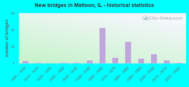
- New bridges - historical statistics
- 31900-1909
- 11910-1919
- 11930-1939
- 11940-1949
- 41950-1959
- 431960-1969
- 71970-1979
- 261980-1989
- 61990-1999
- 112000-2009
- 42010-2019
- 12020-2022

- Reconstructed bridges - Historical Statistics
- 11960-1969
- 11970-1979
- 01980-1989
- 11990-1999
- 72000-2009
- 12010-2019


- Bridge Condition - Deck
- 1.5%Excellent
- 14.9%Very good
- 35.8%Good
- 31.3%Satisfactory
- 4.5%Fair
- 10.4%Poor
- 1.5%Serious

- Bridge Condition - Superstructure
- 1.5%Excellent
- 14.7%Very good
- 35.3%Good
- 26.5%Satisfactory
- 16.2%Fair
- 4.4%Poor
- 1.5%Serious

- Bridge Condition - Substructure
- 1.5%Excellent
- 5.9%Very good
- 42.6%Good
- 23.5%Satisfactory
- 26.5%Fair

- Bridge Condition - Channel
- 4.8%Very good
- 24.2%Good
- 30.6%Satisfactory
- 33.9%Fair
- 4.8%Poor
- 1.6%Serious

- Bridge Condition - Culverts
- 19.0%Very good
- 28.6%Good
- 33.3%Satisfactory
- 19.0%Fair
Find on map >> Show street view
Structure Number: 156331, Location: MATTOON- US 45 (Lat: 39.489069, Lng: -88.373394), Route carried "on" structure: Other road , Year Built: 1994, Status: Open, Structure Length: 5.44m (17.85ft), Average Daily Traffic: 7,800 (year 2019), Truck Traffic: 4%, Average Future Daily Traffic: 9,728 (year 2032), Design Load: HS 20+Mod, Features Intersected: IC RR, Facility Carried by Structure: FAU 7666(DEWITT AV
Minimum Vertical Clearance: 30+ m (98+ ft), Kilometerpoint: 0.080, Lanes on structure: 4, Base Highway Network: Yes, Owner: City or Municipal Highway Agency, Approaching Roadway Width: 15.8m (51.8ft), Skew: 1 degrees, Material/Design: Steel continuous, Design/Construction: Stringer/Multi-beam, Number Of Spans In Main Unit: 3, Length of Maximum Span: 21.9m (71.9ft), Curb or Sidewalk Widths: Left: 1.5m (4.9ft), Right: 1.5m (4.9ft), Curb-To-Curb Width: 15.8m (51.8ft), Out-to-Out Width: 19.5m (64.0ft)
Condition: Deck: Satisfactory, Superstructure: Satisfactory, Substructure: Good, Operating Rating: 44.1 metric tons, Method Used To Determine Operating Rating: Assigned rating based on Load Factor Design (LFD) reported by rating factor (RF) using MS18 loading, Inventory Rating: 32.4 metric tons, Method Used To Determine Inventory Rating: Assigned rating based on Load Factor Design (LFD) reported by rating factor (RF) using MS18 loading, Structural Evaluation: Equal to present minimum criteria, Deck Geometry: Meets minimum limits, Underclear: Equal to present desirable criteria, Approach Roadway Alignment: Equal to present desirable criteria, Designated Inspection Frequency: Every 24 months, Inspection Date: July 2021, Deck Structure Type: Concrete Cast-file-Place, Wearing Surface/Protective System: Deck Protection: Epoxy Coated Reinforcing
Find on map >> Show street view
Structure Number: 156336, Location: MATTOON (Lat: 39.484850, Lng: -88.375164), Route carried "on" structure: Other road , Year Built: 2002, Status: Open, Structure Length: 3.27m (10.73ft), Average Daily Traffic: 2,450 (year 2019), Truck Traffic: 2%, Average Future Daily Traffic: 2,970 (year 2032), Design Load: HS 20, Features Intersected: IC RR, Facility Carried by Structure: RICHMOND AVE(FAU76
Minimum Vertical Clearance: 30+ m (98+ ft), Kilometerpoint: 0.418, Lanes on structure: 2, Owner: City or Municipal Highway Agency, Approaching Roadway Width: 8.5m (27.9ft), Skew: 2 degrees, Material/Design: Prestressed concrete, Design/Construction: Box Beam or Girders - Multiple, Number Of Spans In Main Unit: 3, Length of Maximum Span: 13.1m (43.0ft), Curb or Sidewalk Widths: Left: 1.5m (4.9ft), Right: 1.5m (4.9ft), Curb-To-Curb Width: 8.5m (27.9ft), Out-to-Out Width: 8.5m (27.9ft)
Condition: Deck: Satisfactory, Superstructure: Good, Substructure: Satisfactory, Operating Rating: 44.1 metric tons, Method Used To Determine Operating Rating: Assigned rating based on Load Factor Design (LFD) reported by rating factor (RF) using MS18 loading, Inventory Rating: 32.4 metric tons, Method Used To Determine Inventory Rating: Assigned rating based on Load Factor Design (LFD) reported by rating factor (RF) using MS18 loading, Structural Evaluation: Equal to present minimum criteria, Deck Geometry: Meets minimum limits, Underclear: Equal to present desirable criteria, Approach Roadway Alignment: Equal to present desirable criteria, Designated Inspection Frequency: Every 24 months, Inspection Date: July 2021, Deck Structure Type: Concrete Precast Panels
Find on map >> Show street view
Structure Number: 156337, Location: MATTOON (Lat: 39.482622, Lng: -88.376714), Route carried "on" structure: Other road , Year Built: 2002, Status: Open, Structure Length: 3.14m (10.30ft), Average Daily Traffic: 1,200 (year 2021), Truck Traffic: 1%, Average Future Daily Traffic: 1,766 (year 2032), Design Load: HS 20, Features Intersected: IC RR, Facility Carried by Structure: BROADWAY AVE(FAU76
Minimum Vertical Clearance: 30+ m (98+ ft), Kilometerpoint: 0.097, Lanes on structure: 2, Base Highway Network: Yes, Owner: City or Municipal Highway Agency, Approaching Roadway Width: 15.2m (49.9ft), Skew: 2 degrees, Material/Design: Prestressed concrete, Design/Construction: Box Beam or Girders - Multiple, Number Of Spans In Main Unit: 3, Length of Maximum Span: 15.8m (51.8ft), Curb or Sidewalk Widths: Left: 1.5m (4.9ft), Right: 1.5m (4.9ft), Curb-To-Curb Width: 15.8m (51.8ft), Out-to-Out Width: 30.5m (100.1ft)
Condition: Deck: Good, Superstructure: Good, Substructure: Satisfactory, Operating Rating: 44.1 metric tons, Method Used To Determine Operating Rating: Assigned rating based on Load Factor Design (LFD) reported by rating factor (RF) using MS18 loading, Inventory Rating: 32.4 metric tons, Method Used To Determine Inventory Rating: Assigned rating based on Load Factor Design (LFD) reported by rating factor (RF) using MS18 loading, Structural Evaluation: Equal to present minimum criteria, Deck Geometry: Superior to present desirable criteria, Underclear: Equal to present desirable criteria, Approach Roadway Alignment: Equal to present desirable criteria, Designated Inspection Frequency: Every 24 months, Inspection Date: July 2021, Deck Structure Type: Concrete Precast Panels
Find on map >> Show street view
Structure Number: 156338, Location: CHAMP AVE - MATTOON (Lat: 39.485911, Lng: -88.374911), Route carried "on" structure: Other road , Year Built: 2004, Status: Open, Structure Length: 3.29m (10.79ft), Average Daily Traffic: 700 (year 2019), Truck Traffic: 4%, Average Future Daily Traffic: 870 (year 2032), Design Load: HS 20, Features Intersected: CN/ICRR, Facility Carried by Structure: CHAMP AVE (FAU 766
Minimum Vertical Clearance: 30+ m (98+ ft), Kilometerpoint: 0.451, Lanes on structure: 2, Owner: City or Municipal Highway Agency, Approaching Roadway Width: 9.1m (29.9ft), Skew: 2 degrees, Material/Design: Prestressed concrete, Design/Construction: Box Beam or Girders - Multiple, Number Of Spans In Main Unit: 3, Length of Maximum Span: 13.1m (43.0ft), Curb-To-Curb Width: 8.5m (27.9ft), Out-to-Out Width: 8.5m (27.9ft)
Condition: Deck: Satisfactory, Superstructure: Good, Substructure: Satisfactory, Operating Rating: 44.1 metric tons, Method Used To Determine Operating Rating: Assigned rating based on Load Factor Design (LFD) reported by rating factor (RF) using MS18 loading, Inventory Rating: 32.4 metric tons, Method Used To Determine Inventory Rating: Assigned rating based on Load Factor Design (LFD) reported by rating factor (RF) using MS18 loading, Structural Evaluation: Equal to present minimum criteria, Deck Geometry: Somewhat better than minimum adequacy, Underclear: Equal to present desirable criteria, Approach Roadway Alignment: Equal to present desirable criteria, Designated Inspection Frequency: Every 24 months, Inspection Date: July 2021, Deck Structure Type: Concrete Precast Panels
Find on map >> Show street view
Structure Number: 156339, Location: SO 9TH ST MATTOON (Lat: 39.473375, Lng: -88.364269), Route carried "on" structure: Other road , Year Built: 2008, Status: Open, Structure Length: 2.37m (7.78ft), Average Daily Traffic: 4,100 (year 2019), Truck Traffic: 5%, Average Future Daily Traffic: 4,915 (year 2032), Design Load: HS 20, Features Intersected: KICKAPOO CREK, Facility Carried by Structure: FAU 7698/9TH ST
Minimum Vertical Clearance: 30+ m (98+ ft), Kilometerpoint: 0.901, Lanes on structure: 2, Base Highway Network: Yes, Owner: City or Municipal Highway Agency, Approaching Roadway Width: 7.3m (24.0ft), Skew: 1 degrees, Material/Design: Prestressed concrete, Design/Construction: Box Beam or Girders - Multiple, Number Of Spans In Main Unit: 3, Length of Maximum Span: 7.6m (24.9ft), Curb or Sidewalk Widths: Left: 1.8m (5.9ft), Right: 1.8m (5.9ft), Curb-To-Curb Width: 11.0m (36.1ft), Out-to-Out Width: 14.6m (47.9ft)
Condition: Deck: Very good, Superstructure: Very good, Substructure: Good, Channel: Good, Operating Rating: 44.1 metric tons, Method Used To Determine Operating Rating: Assigned rating based on Load Factor Design (LFD) reported by rating factor (RF) using MS18 loading, Inventory Rating: 32.4 metric tons, Method Used To Determine Inventory Rating: Assigned rating based on Load Factor Design (LFD) reported by rating factor (RF) using MS18 loading, Structural Evaluation: Better than present minimum criteria, Deck Geometry: Somewhat better than minimum adequacy, Waterway Adequacy: Equal to present desirable criteria, Approach Roadway Alignment: Equal to present desirable criteria, Designated Inspection Frequency: Every 48 months, Inspection Date: July 2021, Deck Structure Type: Concrete Precast Panels
Find on map >> Show street view
Structure Number: 158318, Location: MP 3.90 (Lat: 39.460447, Lng: -88.308506), Route carried "on" structure: County highway , Year Built: 1909, Status: Open, Structure Length: 0.70m (2.30ft), Average Daily Traffic: 2,950 (year 2019), Truck Traffic: 5%, Average Future Daily Traffic: 3,482 (year 2032), Design Load: HS 20+Mod, Features Intersected: STREAM, Facility Carried by Structure: FAS 673 (LERNA RD)
Minimum Vertical Clearance: 30+ m (98+ ft), Kilometerpoint: 1.223, Lanes on structure: 2, Owner: State Highway Agency, Approaching Roadway Width: 7.3m (24.0ft), Material/Design: Concrete, Design/Construction: Culvert, Number Of Spans In Main Unit: 2, Length of Maximum Span: 3.4m (11.2ft)
Condition: Channel: Fair, Culverts: Fair, Operating Rating: 54.1 metric tons, Method Used To Determine Operating Rating: Field evaluation and documented engineering judgment, Inventory Rating: 32.4 metric tons, Method Used To Determine Inventory Rating: Field evaluation and documented engineering judgment, Structural Evaluation: Somewhat better than minimum adequacy, Waterway Adequacy: Equal to present desirable criteria, Approach Roadway Alignment: Equal to present desirable criteria, Designated Inspection Frequency: Every 24 months, Inspection Date: July 2021
Find on map >> Show street view
Structure Number: 15832, Location: 7.42MI W OF ILL-130 (Lat: 39.506531, Lng: -88.300158), Route carried "on" structure: County highway , Year Built: 2014, Status: Open, Structure Length: 0.87m (2.85ft), Average Daily Traffic: 2,200 (year 2019), Truck Traffic: 5%, Average Future Daily Traffic: 2,150 (year 2032), Features Intersected: STREAM, Facility Carried by Structure: FAS 1669
Minimum Vertical Clearance: 30+ m (98+ ft), Kilometerpoint: 0.338, Lanes on structure: 2, Base Highway Network: Yes, Owner: State Highway Agency, Approaching Roadway Width: 6.7m (22.0ft), Material/Design: Concrete, Design/Construction: Culvert, Number Of Spans In Main Unit: 2, Length of Maximum Span: 4.0m (13.1ft)
Condition: Channel: Very good, Culverts: Very good, Operating Rating: 54.8 metric tons, Method Used To Determine Operating Rating: Load Factor (LF) rating reported by rating factor (RF) method using MS18 loading, Inventory Rating: 32.7 metric tons, Method Used To Determine Inventory Rating: Load Factor (LF) rating reported by rating factor (RF) method using MS18 loading, Structural Evaluation: Equal to present desirable criteria, Waterway Adequacy: Equal to present desirable criteria, Approach Roadway Alignment: Equal to present desirable criteria, Designated Inspection Frequency: Every 48 months, Inspection Date: December 2021
Find on map >> Show street view
Structure Number: 183026, Location: .25 MI E OF TRILLA (Lat: 39.374219, Lng: -88.347269), Route carried "on" structure: County highway , Year Built: 1969, Status: Open, Structure Length: 0.91m (2.99ft), Average Daily Traffic: 350 (year 2021), Truck Traffic: 3%, Average Future Daily Traffic: 734 (year 2032), Features Intersected: CLEAR CREEK, Facility Carried by Structure: TR 7 B
Minimum Vertical Clearance: 30+ m (98+ ft), Kilometerpoint: 0.322, Lanes on structure: 1, Owner: Town or Township Highway Agency, Approaching Roadway Width: 7.3m (24.0ft), Material/Design: Prestressed concrete, Design/Construction: Box Beam or Girders - Multiple, Number Of Spans In Main Unit: 1, Length of Maximum Span: 7.0m (23.0ft), Curb-To-Curb Width: 7.2m (23.6ft), Out-to-Out Width: 7.3m (24.0ft)
Condition: Deck: Good, Superstructure: Good, Substructure: Good, Channel: Good, Operating Rating: 70.0 metric tons, Method Used To Determine Operating Rating: Load Factor (LF) rating reported by rating factor (RF) method using MS18 loading, Inventory Rating: 41.8 metric tons, Method Used To Determine Inventory Rating: Load Factor (LF) rating reported by rating factor (RF) method using MS18 loading, Structural Evaluation: Better than present minimum criteria, Deck Geometry: Meets minimum limits, Waterway Adequacy: Equal to present minimum criteria, Approach Roadway Alignment: Somewhat better than minimum adequacy, Designated Inspection Frequency: Every 24 months, Inspection Date: March 2021, Deck Structure Type: Concrete Precast Panels, Wearing Surface/Protective System: Wearing Surface: Gravel
Find on map >> Show street view
Structure Number: 183042, Location: 4.0 MI NE NEOGA (Lat: 39.371444, Lng: -88.401572), Route carried "on" structure: County highway , Year Built: 1916, Status: Posted for load, Structure Length: 0.88m (2.89ft), Average Daily Traffic: 25 (year 2021), Truck Traffic: 8%, Average Future Daily Traffic: 26 (year 2032), Features Intersected: BUSH CREEK, Facility Carried by Structure: TR 36
Minimum Vertical Clearance: 30+ m (98+ ft), Kilometerpoint: 0.322, Lanes on structure: 1, Owner: Town or Township Highway Agency, Approaching Roadway Width: 3.2m (10.5ft), Skew: 3 degrees, Material/Design: Steel, Design/Construction: Stringer/Multi-beam, Number Of Spans In Main Unit: 1, Length of Maximum Span: 8.1m (26.6ft), Curb-To-Curb Width: 4.7m (15.4ft), Out-to-Out Width: 5.0m (16.4ft)
Condition: Deck: Good, Superstructure: Fair, Substructure: Fair, Channel: Satisfactory, Operating Rating: 23.3 metric tons, Method Used To Determine Operating Rating: Load Factor (LF) rating reported by rating factor (RF) method using MS18 loading, Inventory Rating: 13.9 metric tons, Method Used To Determine Inventory Rating: Load Factor (LF) rating reported by rating factor (RF) method using MS18 loading, Structural Evaluation: Meets minimum limits, Deck Geometry: Better than present minimum criteria, Waterway Adequacy: Meets minimum limits, Approach Roadway Alignment: Meets minimum limits, Bridge Posting: Required (Relationship of Operating Rating to Maximum Legal Load: > 39.9% below), Designated Inspection Frequency: Every 24 months, Inspection Date: March 2021, Deck Structure Type: Concrete Cast-file-Place, Wearing Surface/Protective System: Wearing Surface: Gravel
Find on map >> Show street view
Structure Number: 183134, Location: 0.7 MI SE TRILLA (Lat: 39.372475, Lng: -88.341639), Route carried "on" structure: County highway , Year Built: 1978, Status: Open, Structure Length: 1.16m (3.81ft), Average Daily Traffic: 150 (year 2021), Truck Traffic: 1%, Average Future Daily Traffic: 262 (year 2032), Design Load: HS 20, Features Intersected: CLEAR CREEK, Facility Carried by Structure: TR 80
Minimum Vertical Clearance: 30+ m (98+ ft), Kilometerpoint: 0.193, Lanes on structure: 2, Owner: Town or Township Highway Agency, Approaching Roadway Width: 7.3m (24.0ft), Skew: 1 degrees, Material/Design: Concrete, Design/Construction: Channel Beam, Number Of Spans In Main Unit: 1, Length of Maximum Span: 10.7m (35.1ft), Curb-To-Curb Width: 8.0m (26.2ft), Out-to-Out Width: 8.0m (26.2ft)
Condition: Deck: Good, Superstructure: Good, Substructure: Good, Channel: Satisfactory, Operating Rating: 44.4 metric tons, Method Used To Determine Operating Rating: Assigned rating based on Load Factor Design (LFD) reported by rating factor (RF) using MS18 loading, Inventory Rating: 32.4 metric tons, Method Used To Determine Inventory Rating: Assigned rating based on Load Factor Design (LFD) reported by rating factor (RF) using MS18 loading, Structural Evaluation: Better than present minimum criteria, Deck Geometry: Somewhat better than minimum adequacy, Waterway Adequacy: Equal to present minimum criteria, Approach Roadway Alignment: Equal to present desirable criteria, Designated Inspection Frequency: Every 48 months, Inspection Date: March 2021, Deck Structure Type: Concrete Precast Panels, Wearing Surface/Protective System: Wearing Surface: Gravel
Find on map >> Show street view
Structure Number: 150001, Location: S OF MATTOON (Lat: 39.426014, Lng: -88.378206), Route carried "under" structure: US 45, Year Built: 1965, Structure Length: 0. m, Average Daily Traffic: 7,000 (year 2021), Truck Traffic: 11%, Features Intersected: US 45(FAP 824), Facility Carried by Structure: I-57 (NB)
Minimum Vertical Clearance: 4.57m (14.99ft), Kilometerpoint: 317.096, Lanes on structure: 2, Lanes under structure: 4, Material/Design: Steel continuous, Design/Construction: Stringer/Multi-beam, Length of Maximum Span: 20.7m (67.9ft)
Find on map >> Show street view
Structure Number: 150002, Location: S OF MATTOON (Lat: 39.426211, Lng: -88.378219), Route carried "under" structure: US 45, Year Built: 1965, Structure Length: 0. m, Average Daily Traffic: 7,000 (year 2021), Truck Traffic: 11%, Features Intersected: US 45(FAP 824), Facility Carried by Structure: I-57 (SB)
Minimum Vertical Clearance: 4.67m (15.32ft), Kilometerpoint: 317.129, Lanes on structure: 2, Lanes under structure: 4, Material/Design: Steel continuous, Design/Construction: Stringer/Multi-beam, Length of Maximum Span: 20.7m (67.9ft)
Find on map >> Show street view
Structure Number: 150003, Location: JONES SWITCH (Lat: 39.453589, Lng: -88.337011), Route carried "under" structure: County highway , Year Built: 1965, Structure Length: 0. m, Average Daily Traffic: 225 (year 2019), Truck Traffic: 7%, Features Intersected: IC RR & TR 86, Facility Carried by Structure: I-57 (SB)
Minimum Vertical Clearance: 7.34m (24.08ft), Kilometerpoint: 1.529, Lanes on structure: 2, Lanes under structure: 2, Material/Design: Steel continuous, Design/Construction: Stringer/Multi-beam, Length of Maximum Span: 17.0m (55.8ft)
Find on map >> Show street view
Structure Number: 150004, Location: JONES SWITCH (Lat: 39.453489, Lng: -88.336836), Route carried "under" structure: County highway , Year Built: 1965, Structure Length: 0. m, Average Daily Traffic: 225 (year 2019), Truck Traffic: 7%, Features Intersected: IC RR & TR 86, Facility Carried by Structure: I-57 (NB)
Minimum Vertical Clearance: 7.34m (24.08ft), Kilometerpoint: 1.561, Lanes on structure: 2, Lanes under structure: 2, Material/Design: Steel continuous, Design/Construction: Stringer/Multi-beam, Length of Maximum Span: 17.0m (55.8ft)
Find on map >> Show street view
Structure Number: 150005, Location: E MATTOON (Lat: 39.484300, Lng: -88.321539), Route carried "under" structure: State highway 16, Year Built: 1963, Structure Length: 0. m, Average Daily Traffic: 15,400 (year 2021), Truck Traffic: 4%, Features Intersected: IL 16 (FAP 91), Facility Carried by Structure: I-57 (NB)
Minimum Vertical Clearance: 4.72m (15.49ft), Kilometerpoint: 224.015, Lanes on structure: 3, Lanes under structure: 6, Material/Design: Steel continuous, Design/Construction: Stringer/Multi-beam, Length of Maximum Span: 21.9m (71.9ft)
Find on map >> Show street view
Structure Number: 150006, Location: E MATTOON (Lat: 39.484300, Lng: -88.321831), Route carried "under" structure: State highway 16, Year Built: 1963, Structure Length: 0. m, Average Daily Traffic: 15,500 (year 2021), Truck Traffic: 6%, Features Intersected: IL 16 (FAP 325), Facility Carried by Structure: I-57 (SB)
Minimum Vertical Clearance: 4.55m (14.93ft), Kilometerpoint: 223.982, Lanes on structure: 3, Lanes under structure: 6, Material/Design: Steel continuous, Design/Construction: Stringer/Multi-beam, Length of Maximum Span: 21.9m (71.9ft)
Find on map >> Show street view
Structure Number: 150029, Location: 1.0 MI E OF US 45 (Lat: 39.435831, Lng: -88.363761), Route carried "under" structure: Interstate 57, Year Built: 1964, Structure Length: 0. m, Average Daily Traffic: 20,200 (year 2021), Truck Traffic: 42%, Features Intersected: I-57, Facility Carried by Structure: TR 223
Minimum Vertical Clearance: 5.16m (16.93ft), Kilometerpoint: 298.107, Lanes on structure: 2, Lanes under structure: 4, Material/Design: Steel continuous, Design/Construction: Stringer/Multi-beam, Length of Maximum Span: 21.2m (69.6ft)
Find on map >> Show street view
Structure Number: 150032, Location: COUNTRY CB RD S 16 (Lat: 39.469439, Lng: -88.321139), Route carried "under" structure: Interstate 57, Year Built: 1965, Structure Length: 0. m, Average Daily Traffic: 20,200 (year 2021), Truck Traffic: 42%, Features Intersected: KICKAPOO CR & I-57, Facility Carried by Structure: FAU 7702(CH 7)
Minimum Vertical Clearance: 5.23m (17.16ft), Kilometerpoint: 303.466, Lanes on structure: 2, Lanes under structure: 4, Material/Design: Steel continuous, Design/Construction: Stringer/Multi-beam, Length of Maximum Span: 21.5m (70.5ft)
Find on map >> Show street view
Structure Number: 150037, Location: 1.0 MI N CUMB CO LN (Lat: 39.388631, Lng: -88.406181), Route carried "under" structure: Interstate 57, Year Built: 1964, Structure Length: 0. m, Average Daily Traffic: 21,400 (year 2021), Truck Traffic: 40%, Features Intersected: I-57, Facility Carried by Structure: FAS 1605(CH 11)
Minimum Vertical Clearance: 5.31m (17.42ft), Kilometerpoint: 291.509, Lanes on structure: 2, Lanes under structure: 4, Material/Design: Concrete continuous, Design/Construction: Tee Beam, Length of Maximum Span: 21.9m (71.9ft)
Find on map >> Show street view
Structure Number: 150044, Location: 2 MI N EXIT 192 (Lat: 39.550131, Lng: -88.312969), Route carried "under" structure: Interstate 57, Year Built: 1965, Structure Length: 0. m, Average Daily Traffic: 23,400 (year 2021), Truck Traffic: 37%, Features Intersected: I-57, Facility Carried by Structure: CH 22
Minimum Vertical Clearance: 5.23m (17.16ft), Kilometerpoint: 312.558, Lanes on structure: 2, Lanes under structure: 4, Material/Design: Concrete continuous, Design/Construction: Tee Beam, Length of Maximum Span: 20.5m (67.3ft)
Find on map >> Show street view
Structure Number: 150047, Location: 2.0 MI E OF US 45 (Lat: 39.444661, Lng: -88.350469), Route carried "under" structure: Interstate 57, Year Built: 1965, Structure Length: 0. m, Average Daily Traffic: 20,200 (year 2021), Truck Traffic: 42%, Features Intersected: I-57, Facility Carried by Structure: TR 70 A
Minimum Vertical Clearance: 5.16m (16.93ft), Kilometerpoint: 299.636, Lanes on structure: 2, Lanes under structure: 4, Material/Design: Steel continuous, Design/Construction: Stringer/Multi-beam, Length of Maximum Span: 21.2m (69.6ft)
Find on map >> Show street view
Structure Number: 150048, Location: 3.5 MI N OF IL 16 (Lat: 39.535661, Lng: -88.313139), Route carried "under" structure: Interstate 57, Year Built: 1966, Structure Length: 0. m, Average Daily Traffic: 23,400 (year 2021), Truck Traffic: 37%, Features Intersected: I-57, Facility Carried by Structure: TR 119B
Minimum Vertical Clearance: 5.23m (17.16ft), Kilometerpoint: 310.965, Lanes on structure: 2, Lanes under structure: 4, Material/Design: Concrete continuous, Design/Construction: Tee Beam, Length of Maximum Span: 20.5m (67.3ft)
Find on map >> Show street view
Structure Number: 150049, Location: 1.5 MI N OF IL 16 (Lat: 39.506489, Lng: -88.320361), Route carried "under" structure: Interstate 57, Year Built: 1966, Structure Length: 0. m, Average Daily Traffic: 21,300 (year 2021), Truck Traffic: 41%, Features Intersected: I-57, Facility Carried by Structure: TR 141
Minimum Vertical Clearance: 5.31m (17.42ft), Kilometerpoint: 307.602, Lanes on structure: 2, Lanes under structure: 4, Material/Design: Concrete continuous, Design/Construction: Tee Beam, Length of Maximum Span: 22.2m (72.8ft)
Find on map >> Show street view
Structure Number: 15005, Location: 1.5 MI SW OF US 45 (Lat: 39.410569, Lng: -88.395881), Route carried "under" structure: Interstate 57, Year Built: 1964, Structure Length: 0. m, Average Daily Traffic: 21,400 (year 2021), Truck Traffic: 40%, Features Intersected: I-57, Facility Carried by Structure: TR 245(FAS 1667)
Minimum Vertical Clearance: 5.33m (17.49ft), Kilometerpoint: 294.100, Lanes on structure: 2, Lanes under structure: 4, Material/Design: Steel continuous, Design/Construction: Stringer/Multi-beam, Length of Maximum Span: 21.8m (71.5ft)
Find on map >> Show street view
Structure Number: 150053, Location: 0.5 MI N OF IL 16 (Lat: 39.491589, Lng: -88.321589), Route carried "under" structure: Other road , Year Built: 1965, Structure Length: 0. m, Average Daily Traffic: 3,350 (year 2019), Truck Traffic: 7%, Features Intersected: SBI 16(FAU 7666), Facility Carried by Structure: I-57 (NB)
Minimum Vertical Clearance: 6.91m (22.67ft), Kilometerpoint: 4.522, Lanes on structure: 2, Lanes under structure: 2, Material/Design: Steel continuous, Design/Construction: Stringer/Multi-beam, Length of Maximum Span: 16.4m (53.8ft)
Find on map >> Show street view
Structure Number: 150054, Location: 0.5 MI N OF IL 16 (Lat: 39.491581, Lng: -88.321950), Route carried "under" structure: Other road , Year Built: 1965, Structure Length: 0. m, Average Daily Traffic: 3,350 (year 2019), Truck Traffic: 7%, Features Intersected: SBI 16(FAU 7666), Facility Carried by Structure: I-57 (SB)
Minimum Vertical Clearance: 7.04m (23.10ft), Kilometerpoint: 4.490, Lanes on structure: 2, Lanes under structure: 2, Material/Design: Steel continuous, Design/Construction: Stringer/Multi-beam, Length of Maximum Span: 16.4m (53.8ft)
Find on map >> Show street view
Structure Number: 150073, Location: 2.6 MI. N. IL.16 (Lat: 39.521506, Lng: -88.313361), Route carried "under" structure: Interstate 57, Year Built: 2006, Structure Length: 0. m, Average Daily Traffic: 23,400 (year 2021), Truck Traffic: 37%, Features Intersected: I-57, Facility Carried by Structure: FAU 7706
Minimum Vertical Clearance: 5.36m (17.59ft), Kilometerpoint: 309.404, Lanes on structure: 2, Lanes under structure: 4, Material/Design: Prestressed concrete, Design/Construction: Stringer/Multi-beam, Length of Maximum Span: 33.5m (109.9ft)
Find on map >> Show street view
Structure Number: 153014, Location: AT ETNA (Lat: 39.388756, Lng: -88.420814), Route carried "under" structure: County highway , Year Built: 1900, Structure Length: 0. m, Average Daily Traffic: 600 (year 2019), Truck Traffic: 5%, Features Intersected: FAS 1605, Facility Carried by Structure: IC RR
Minimum Vertical Clearance: 3.94m (12.93ft), Kilometerpoint: 1.979, Lanes under structure: 2, Material/Design: Steel, Design/Construction: Girder and Floorbeam System, Length of Maximum Span: 12.0m (39.4ft)
Find on map >> Show street view
Structure Number: 1534, Location: 2.3 MILE N MATTOON (Lat: 39.520603, Lng: -88.358897), Route carried "under" structure: US 45, Year Built: 2007, Structure Length: 0. m, Average Daily Traffic: 3,000 (year 2021), Truck Traffic: 9%, Features Intersected: US 45 & R.R., Facility Carried by Structure: FAU 7706
Minimum Vertical Clearance: 7.80m (25.59ft), Kilometerpoint: 328.249, Lanes on structure: 2, Lanes under structure: 2, Material/Design: Steel, Design/Construction: Stringer/Multi-beam, Length of Maximum Span: 40.3m (132.2ft)