Bridge Statistics for McAlester, Oklahoma (OK)
Condition, Traffic, Stress, Structural Evaluation, Project Costs
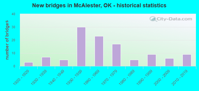
- New bridges - historical statistics
- 31920-1929
- 71930-1939
- 51940-1949
- 301950-1959
- 231960-1969
- 171970-1979
- 51980-1989
- 91990-1999
- 62000-2009
- 92010-2019
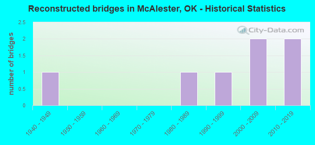
- Reconstructed bridges - Historical Statistics
- 11940-1949
- 01950-1959
- 01960-1969
- 01970-1979
- 11980-1989
- 11990-1999
- 22000-2009
- 22010-2019
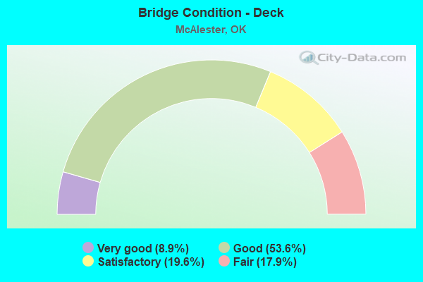
- Bridge Condition - Deck
- 8.9%Very good
- 53.6%Good
- 19.6%Satisfactory
- 17.9%Fair
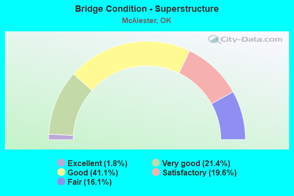
- Bridge Condition - Superstructure
- 1.8%Excellent
- 21.4%Very good
- 41.1%Good
- 19.6%Satisfactory
- 16.1%Fair
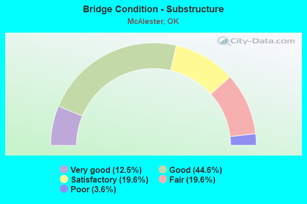
- Bridge Condition - Substructure
- 12.5%Very good
- 44.6%Good
- 19.6%Satisfactory
- 19.6%Fair
- 3.6%Poor
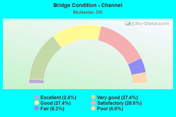
- Bridge Condition - Channel
- 2.4%Excellent
- 27.4%Very good
- 27.4%Good
- 28.6%Satisfactory
- 8.3%Fair
- 6.0%Poor
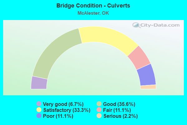
- Bridge Condition - Culverts
- 6.7%Very good
- 35.6%Good
- 33.3%Satisfactory
- 11.1%Fair
- 11.1%Poor
- 2.2%Serious
Find on map >> Show street view
Structure Number: DAPAMCMCA000529, Location: WEST OF FRONT GATE (Lat: 34.839761, Lng: -95.847961), Route carried "on" structure: Other road , Year Built: 1943, Status: Open, Structure Length: 5.12m (16.80ft), Average Daily Traffic: 2,500 (year 2016), Truck Traffic: 10%, Average Future Daily Traffic: 2,500 (year 2043), Features Intersected: PEACEABLE CREEK, Facility Carried by Structure: C-TREE ROAD
Minimum Vertical Clearance: 30+ m (98+ ft), Kilometerpoint: 0.000, Lanes on structure: 2, Owner: Army, Approaching Roadway Width: 9.6m (31.5ft), Material/Design: Concrete continuous, Design/Construction: Slab, Number Of Spans In Main Unit: 4, Length of Maximum Span: 14.6m (47.9ft), Curb or Sidewalk Widths: Left: 1.1m (3.6ft), Right: 1.1m (3.6ft), Curb-To-Curb Width: 10.4m (34.1ft), Out-to-Out Width: 13.0m (42.7ft)
Condition: Deck: Good, Superstructure: Good, Substructure: Poor, Channel: Satisfactory, Deck Geometry: Somewhat better than minimum adequacy, Waterway Adequacy: Better than present minimum criteria, Approach Roadway Alignment: Equal to present desirable criteria, Length Of Structure Improvement: 6.14m (20.14ft), Designated Inspection Frequency: Every 24 months, Inspection Date: October 2021, Bridge Improvement Cost: $1,000, Roadway Improvement Cost: $1,000, Total Project Cost: $2,000 ( Estimate for 2021), Deck Structure Type: Concrete Cast-file-Place, Wearing Surface/Protective System: Wearing Surface: Bituminous
Find on map >> Show street view
Structure Number: DAPAMCMCA00053, Location: SOUTH C-TREE RD (Lat: 34.838161, Lng: -95.858039), Route carried "on" structure: ServiceOther road , Year Built: 2016, Status: Open, Structure Length: 4.55m (14.93ft), Average Daily Traffic: 200 (year 2016), Truck Traffic: 5%, Average Future Daily Traffic: 200 (year 2043), Design Load: HL 93, Features Intersected: BULL CREEK, Facility Carried by Structure: UNNAMED ROAD
Minimum Vertical Clearance: 30+ m (98+ ft), Kilometerpoint: 0.000, Lanes on structure: 2, Owner: Army, Approaching Roadway Width: 10.2m (33.5ft), Material/Design: Steel, Design/Construction: Truss - Thru, Number Of Spans In Main Unit: 1, Length of Maximum Span: 43.6m (143.0ft), Curb-To-Curb Width: 9.8m (32.2ft), Out-to-Out Width: 10.4m (34.1ft)
Condition: Deck: Good, Superstructure: Good, Substructure: Good, Channel: Very good, Deck Geometry: Better than present minimum criteria, Waterway Adequacy: Equal to present desirable criteria, Approach Roadway Alignment: Equal to present desirable criteria, Length Of Structure Improvement: 5.40m (17.72ft), Designated Inspection Frequency: Every 24 months, Critical Feature Inspection Frequency: Every 24 months, Inspection Date: October 2021, Critical Feature Inspection Date: October 2021, Bridge Improvement Cost: $1,000, Roadway Improvement Cost: $1,000, Total Project Cost: $2,000 ( Estimate for 2021), Deck Structure Type: Concrete Cast-file-Place
Find on map >> Show street view
Structure Number: DAPAMCMCA000531, Location: BETWEEN C-TREE & ROAD 4 (Lat: 34.843169, Lng: -95.917019), Route carried "on" structure: ServiceOther road , Year Built: 1993, Status: Posted for load, Structure Length: 1.83m (6.00ft), Average Daily Traffic: 100 (year 2016), Truck Traffic: 10%, Average Future Daily Traffic: 100 (year 2043), Features Intersected: BULL CREEK, Facility Carried by Structure: RD F
Minimum Vertical Clearance: 30+ m (98+ ft), Kilometerpoint: 0.000, Lanes on structure: 2, Owner: Army, Approaching Roadway Width: 7.4m (24.3ft), Material/Design: Prestressed concrete, Design/Construction: Tee Beam, Number Of Spans In Main Unit: 2, Length of Maximum Span: 8.8m (28.9ft), Curb-To-Curb Width: 7.9m (25.9ft), Out-to-Out Width: 8.8m (28.9ft)
Condition: Deck: Good, Superstructure: Good, Substructure: Good, Channel: Fair, Deck Geometry: Equal to present minimum criteria, Waterway Adequacy: Equal to present desirable criteria, Approach Roadway Alignment: Equal to present desirable criteria, Length Of Structure Improvement: 2.55m (8.37ft), Designated Inspection Frequency: Every 24 months, Inspection Date: October 2021, Bridge Improvement Cost: $1,000, Roadway Improvement Cost: $1,000, Total Project Cost: $2,000 ( Estimate for 2021), Deck Structure Type: Concrete Cast-file-Place
Find on map >> Show street view
Structure Number: DAPAMCMCA000532, Location: BETWEEN ROAD A & B (Lat: 34.782161, Lng: -96.006219), Route carried "on" structure: ServiceOther road , Year Built: 1943, Status: Open, Structure Length: 1.37m (4.49ft), Average Daily Traffic: 100 (year 2021), Truck Traffic: 10%, Average Future Daily Traffic: 100 (year 2043), Features Intersected: UNNAMED CREEK, Facility Carried by Structure: ASHLAND ROAD
Minimum Vertical Clearance: 30+ m (98+ ft), Kilometerpoint: 0.000, Lanes on structure: 2, Owner: Army, Approaching Roadway Width: 7.0m (23.0ft), Material/Design: Concrete, Design/Construction: Culvert, Number Of Spans In Main Unit: 3, Length of Maximum Span: 5.2m (17.1ft), Curb-To-Curb Width: 8.1m (26.6ft), Out-to-Out Width: 8.7m (28.5ft)
Condition: Channel: Fair, Culverts: Good, Deck Geometry: Equal to present minimum criteria, Waterway Adequacy: Better than present minimum criteria, Approach Roadway Alignment: Equal to present desirable criteria, Length Of Structure Improvement: 2.04m (6.69ft), Designated Inspection Frequency: Every 24 months, Inspection Date: October 2021, Bridge Improvement Cost: $7,000, Roadway Improvement Cost: $20,000, Total Project Cost: $27,000 ( Estimate for 2021)
Find on map >> Show street view
Structure Number: DAPAMCMCA000533, Location: BETWEEN ROAD C & D (Lat: 34.782139, Lng: -95.966461), Route carried "on" structure: ServiceOther road , Year Built: 1993, Status: Posted for load, Structure Length: 1.41m (4.63ft), Average Daily Traffic: 100 (year 2016), Truck Traffic: 10%, Average Future Daily Traffic: 100 (year 2043), Features Intersected: UNNAMED CREEK, Facility Carried by Structure: ASHLAND ROAD
Minimum Vertical Clearance: 30+ m (98+ ft), Kilometerpoint: 0.000, Lanes on structure: 2, Owner: Army, Approaching Roadway Width: 7.0m (23.0ft), Material/Design: Concrete, Design/Construction: Culvert, Number Of Spans In Main Unit: 3, Length of Maximum Span: 4.5m (14.8ft), Curb-To-Curb Width: 8.1m (26.6ft), Out-to-Out Width: 8.7m (28.5ft)
Condition: Channel: Good, Culverts: Satisfactory, Deck Geometry: Equal to present minimum criteria, Waterway Adequacy: Better than present minimum criteria, Approach Roadway Alignment: Equal to present desirable criteria, Length Of Structure Improvement: 2.09m (6.86ft), Designated Inspection Frequency: Every 24 months, Inspection Date: October 2021, Bridge Improvement Cost: $17,000, Roadway Improvement Cost: $5,000, Total Project Cost: $22,000 ( Estimate for 2021)
Find on map >> Show street view
Structure Number: DAPAMCMCA000534, Location: BTW SECTIONS 57SH & 52SH (Lat: 34.882689, Lng: -95.954119), Route carried "on" structure: ServiceOther road , Year Built: 1954, Status: Open, Structure Length: 2.74m (8.99ft), Average Daily Traffic: 100 (year 2016), Truck Traffic: 10%, Average Future Daily Traffic: 100 (year 2043), Features Intersected: UNNAMED CREEK, Facility Carried by Structure: GRAVEL RD, 57 SH
Minimum Vertical Clearance: 30+ m (98+ ft), Kilometerpoint: 0.000, Lanes on structure: 2, Owner: Army, Approaching Roadway Width: 6.1m (20.0ft), Material/Design: Wood or Timber, Design/Construction: Stringer/Multi-beam, Number Of Spans In Main Unit: 6, Length of Maximum Span: 4.6m (15.1ft), Curb-To-Curb Width: 6.7m (22.0ft), Out-to-Out Width: 7.2m (23.6ft)
Condition: Deck: Good, Superstructure: Satisfactory, Substructure: Fair, Channel: Good, Deck Geometry: Somewhat better than minimum adequacy, Waterway Adequacy: Better than present minimum criteria, Approach Roadway Alignment: Equal to present desirable criteria, Length Of Structure Improvement: 3.66m (12.01ft), Designated Inspection Frequency: Every 24 months, Inspection Date: October 2021, Bridge Improvement Cost: $1,000, Roadway Improvement Cost: $1,000, Total Project Cost: $2,000 ( Estimate for 2021), Deck Structure Type: Concrete Cast-file-Place, Wearing Surface/Protective System: Wearing Surface: Integral Concrete
Find on map >> Show street view
Structure Number: DAPAMCMCA000535, Location: BTW SECTIONS 57SH & 52SH (Lat: 34.881239, Lng: -95.954189), Route carried "on" structure: ServiceOther road , Year Built: 1954, Status: Open, Structure Length: 2.74m (8.99ft), Average Daily Traffic: 100 (year 2016), Truck Traffic: 10%, Average Future Daily Traffic: 100 (year 2043), Features Intersected: UNNAMED CREEK, Facility Carried by Structure: GRAVEL RD, 57SH
Minimum Vertical Clearance: 30+ m (98+ ft), Kilometerpoint: 0.000, Lanes on structure: 2, Owner: Army, Approaching Roadway Width: 6.1m (20.0ft), Material/Design: Wood or Timber, Design/Construction: Stringer/Multi-beam, Number Of Spans In Main Unit: 6, Length of Maximum Span: 4.6m (15.1ft), Curb-To-Curb Width: 6.7m (22.0ft), Out-to-Out Width: 7.2m (23.6ft)
Condition: Deck: Good, Superstructure: Satisfactory, Substructure: Satisfactory, Channel: Satisfactory, Deck Geometry: Somewhat better than minimum adequacy, Waterway Adequacy: Better than present minimum criteria, Approach Roadway Alignment: Equal to present desirable criteria, Length Of Structure Improvement: 3.66m (12.01ft), Designated Inspection Frequency: Every 24 months, Inspection Date: October 2021, Bridge Improvement Cost: $1,000, Roadway Improvement Cost: $1,000, Total Project Cost: $2,000 ( Estimate for 2021), Deck Structure Type: Concrete Cast-file-Place, Wearing Surface/Protective System: Wearing Surface: Integral Concrete
Find on map >> Show street view
Structure Number: DAPAMCMCA000536, Location: NORTH OF ROAD 4 (Lat: 34.835631, Lng: -95.899750), Route carried "on" structure: ServiceOther road , Year Built: 1993, Status: Open, Structure Length: 1.85m (6.07ft), Average Daily Traffic: 100 (year 2016), Truck Traffic: 10%, Average Future Daily Traffic: 100 (year 2043), Design Load: HS 20, Features Intersected: UNNAMED CREEK, Facility Carried by Structure: ROAD G
Minimum Vertical Clearance: 30+ m (98+ ft), Kilometerpoint: 0.000, Lanes on structure: 2, Owner: Army, Approaching Roadway Width: 6.7m (22.0ft), Material/Design: Prestressed concrete, Design/Construction: Tee Beam, Number Of Spans In Main Unit: 2, Length of Maximum Span: 9.2m (30.2ft), Curb-To-Curb Width: 8.0m (26.2ft), Out-to-Out Width: 8.5m (27.9ft)
Condition: Deck: Good, Superstructure: Good, Substructure: Satisfactory, Channel: Good, Deck Geometry: Equal to present minimum criteria, Waterway Adequacy: Better than present minimum criteria, Approach Roadway Alignment: Equal to present desirable criteria, Length Of Structure Improvement: 2.55m (8.37ft), Designated Inspection Frequency: Every 24 months, Inspection Date: October 2021, Bridge Improvement Cost: $1,000, Roadway Improvement Cost: $1,000, Total Project Cost: $2,000 ( Estimate for 2021), Deck Structure Type: Concrete Cast-file-Place
Find on map >> Show street view
Structure Number: DAPAMCMCA000537, Location: SECTION 36AT (Lat: 34.818931, Lng: -95.892300), Route carried "on" structure: ServiceOther road , Year Built: 1954, Status: Posted for load, Structure Length: 2.74m (8.99ft), Average Daily Traffic: 100 (year 2016), Truck Traffic: 10%, Average Future Daily Traffic: 100 (year 2043), Design Load: H 20, Features Intersected: UNNAMED CREEK, Facility Carried by Structure: GRAVEL RD, 36AT
Minimum Vertical Clearance: 30+ m (98+ ft), Kilometerpoint: 0.000, Lanes on structure: 1, Owner: Army, Approaching Roadway Width: 6.1m (20.0ft), Material/Design: Wood or Timber, Design/Construction: Stringer/Multi-beam, Number Of Spans In Main Unit: 6, Length of Maximum Span: 4.6m (15.1ft), Curb-To-Curb Width: 6.7m (22.0ft), Out-to-Out Width: 7.2m (23.6ft)
Condition: Deck: Fair, Superstructure: Satisfactory, Substructure: Satisfactory, Channel: Satisfactory, Deck Geometry: Somewhat better than minimum adequacy, Waterway Adequacy: Better than present minimum criteria, Approach Roadway Alignment: Equal to present minimum criteria, Length Of Structure Improvement: 3.66m (12.01ft), Designated Inspection Frequency: Every 24 months, Inspection Date: October 2021, Bridge Improvement Cost: $1,000, Roadway Improvement Cost: $1,000, Total Project Cost: $2,000 ( Estimate for 2021), Deck Structure Type: Concrete Cast-file-Place
Find on map >> Show street view
Structure Number: DAPAMCMCA000561, Location: BTW SECTIONS 46PC & 46LC (Lat: 34.857900, Lng: -95.982681), Route carried "on" structure: ServiceOther road , Year Built: 1954, Status: Posted for load, Structure Length: 1.52m (4.99ft), Average Daily Traffic: 100 (year 2016), Truck Traffic: 10%, Average Future Daily Traffic: 100 (year 2043), Features Intersected: UNNAMED CREEK, Facility Carried by Structure: GRAVEL RD, 46LC
Minimum Vertical Clearance: 30+ m (98+ ft), Kilometerpoint: 0.000, Lanes on structure: 2, Owner: Army, Approaching Roadway Width: 6.1m (20.0ft), Material/Design: Wood or Timber, Design/Construction: Stringer/Multi-beam, Number Of Spans In Main Unit: 4, Length of Maximum Span: 3.4m (11.2ft), Curb-To-Curb Width: 6.7m (22.0ft), Out-to-Out Width: 7.2m (23.6ft)
Condition: Deck: Good, Superstructure: Good, Substructure: Good, Channel: Satisfactory, Deck Geometry: Somewhat better than minimum adequacy, Waterway Adequacy: Better than present minimum criteria, Approach Roadway Alignment: Equal to present desirable criteria, Length Of Structure Improvement: 2.20m (7.22ft), Designated Inspection Frequency: Every 24 months, Inspection Date: October 2021, Bridge Improvement Cost: $1,000, Roadway Improvement Cost: $1,000, Total Project Cost: $2,000 ( Estimate for 2021), Deck Structure Type: Concrete Cast-file-Place, Wearing Surface/Protective System: Wearing Surface: Integral Concrete
Find on map >> Show street view
Structure Number: DAPAMCMCA000595, Location: S STANTON ROAD (Lat: 34.878239, Lng: -95.948119), Route carried "on" structure: ServiceOther road , Year Built: 1954, Status: Open, Structure Length: 1.77m (5.81ft), Average Daily Traffic: 100 (year 2016), Truck Traffic: 10%, Average Future Daily Traffic: 100 (year 2043), Features Intersected: UNNAMED CREEK, Facility Carried by Structure: C TREE ROAD
Minimum Vertical Clearance: 30+ m (98+ ft), Kilometerpoint: 0.000, Lanes on structure: 2, Owner: Army, Approaching Roadway Width: 8.5m (27.9ft), Skew: 2 degrees, Material/Design: Concrete, Design/Construction: Culvert, Number Of Spans In Main Unit: 10, Length of Maximum Span: 1.2m (3.9ft)
Condition: Channel: Satisfactory, Culverts: Satisfactory, Operating Rating: 54.5 metric tons, Method Used To Determine Operating Rating: Field evaluation and documented engineering judgment, Inventory Rating: 32.7 metric tons, Method Used To Determine Inventory Rating: Field evaluation and documented engineering judgment, Structural Evaluation: Equal to present minimum criteria, Waterway Adequacy: Better than present minimum criteria, Approach Roadway Alignment: Equal to present desirable criteria, Length Of Structure Improvement: 2.48m (8.14ft), Designated Inspection Frequency: Every 24 months, Inspection Date: October 2021, Bridge Improvement Cost: $8,000, Roadway Improvement Cost: $2,000, Total Project Cost: $10,000 ( Estimate for 2021)
Find on map >> Show street view
Structure Number: DAPAMCMCA000N15, Location: SOUTH OF ROAD 7 (Lat: 34.796439, Lng: -95.961819), Route carried "on" structure: ServiceOther road , Year Built: 1950, Status: Open, Structure Length: 0.73m (2.40ft), Average Daily Traffic: 100 (year 2021), Truck Traffic: 10%, Average Future Daily Traffic: 100 (year 2043), Features Intersected: UNNAMED CREEK, Facility Carried by Structure: ROAD D
Minimum Vertical Clearance: 30+ m (98+ ft), Kilometerpoint: 0.000, Lanes on structure: 2, Owner: Army, Approaching Roadway Width: 7.3m (24.0ft), Skew: 3 degrees, Material/Design: Concrete, Design/Construction: Culvert, Number Of Spans In Main Unit: 3, Length of Maximum Span: 1.8m (5.9ft)
Condition: Channel: Satisfactory, Culverts: Fair, Operating Rating: 54.5 metric tons, Method Used To Determine Operating Rating: Field evaluation and documented engineering judgment, Inventory Rating: 32.7 metric tons, Method Used To Determine Inventory Rating: Field evaluation and documented engineering judgment, Structural Evaluation: Somewhat better than minimum adequacy, Waterway Adequacy: Better than present minimum criteria, Approach Roadway Alignment: Equal to present desirable criteria, Length Of Structure Improvement: 1.37m (4.49ft), Designated Inspection Frequency: Every 24 months, Inspection Date: October 2021, Bridge Improvement Cost: $13,000, Roadway Improvement Cost: $26,000, Total Project Cost: $39,000 ( Estimate for 2021)
Find on map >> Show street view
Structure Number: DAPAMCMCA000N19, Location: 0.4 KM WEST OF ROAD E (Lat: 34.811089, Lng: -95.939511), Route carried "on" structure: ServiceOther road , Year Built: 1950, Status: Open, Structure Length: 0.79m (2.59ft), Average Daily Traffic: 100 (year 2021), Truck Traffic: 10%, Average Future Daily Traffic: 100 (year 2043), Features Intersected: UNNAMED CREEK, Facility Carried by Structure: ROAD 6
Minimum Vertical Clearance: 30+ m (98+ ft), Kilometerpoint: 0.000, Lanes on structure: 2, Owner: Army, Approaching Roadway Width: 6.4m (21.0ft), Skew: 3 degrees, Material/Design: Concrete, Design/Construction: Culvert, Number Of Spans In Main Unit: 4, Length of Maximum Span: 1.8m (5.9ft)
Condition: Channel: Good, Culverts: Satisfactory, Operating Rating: 54.5 metric tons, Method Used To Determine Operating Rating: Field evaluation and documented engineering judgment, Inventory Rating: 32.7 metric tons, Method Used To Determine Inventory Rating: Field evaluation and documented engineering judgment, Structural Evaluation: Equal to present minimum criteria, Waterway Adequacy: Better than present minimum criteria, Approach Roadway Alignment: Equal to present desirable criteria, Length Of Structure Improvement: 1.44m (4.72ft), Designated Inspection Frequency: Every 24 months, Inspection Date: October 2021, Bridge Improvement Cost: $20,000, Roadway Improvement Cost: $31,000, Total Project Cost: $51,000 ( Estimate for 2021)
Find on map >> Show street view
Structure Number: DAPAMCMCA000N27, Location: BETWEEN ROADS 6 AND 7 (Lat: 34.801911, Lng: -95.970139), Route carried "on" structure: ServiceOther road , Year Built: 1938, Status: Open, Structure Length: 0.94m (3.08ft), Average Daily Traffic: 100 (year 2016), Truck Traffic: 10%, Average Future Daily Traffic: 100 (year 2043), Features Intersected: UNNAMED CREEK, Facility Carried by Structure: ROAD C
Minimum Vertical Clearance: 30+ m (98+ ft), Kilometerpoint: 0.000, Lanes on structure: 1, Owner: Army, Approaching Roadway Width: 6.1m (20.0ft), Skew: 4 degrees, Material/Design: Concrete, Design/Construction: Slab, Number Of Spans In Main Unit: 2, Length of Maximum Span: 4.3m (14.1ft), Curb-To-Curb Width: 6.1m (20.0ft), Out-to-Out Width: 7.0m (23.0ft)
Condition: Deck: Satisfactory, Superstructure: Satisfactory, Substructure: Satisfactory, Channel: Fair, Deck Geometry: Somewhat better than minimum adequacy, Waterway Adequacy: Equal to present desirable criteria, Approach Roadway Alignment: Equal to present desirable criteria, Length Of Structure Improvement: 1.61m (5.28ft), Designated Inspection Frequency: Every 24 months, Inspection Date: October 2021, Bridge Improvement Cost: $18,000, Roadway Improvement Cost: $22,000, Total Project Cost: $40,000 ( Estimate for 2021), Deck Structure Type: Concrete Cast-file-Place
Find on map >> Show street view
Structure Number: DAPAMCMCA000N36, Location: WEST OF ROAD E (Lat: 34.838181, Lng: -95.939411), Route carried "on" structure: ServiceOther road , Year Built: 1950, Status: Open, Structure Length: 0.63m (2.07ft), Average Daily Traffic: 100 (year 2016), Truck Traffic: 10%, Average Future Daily Traffic: 100 (year 2043), Features Intersected: BULL CREEK, Facility Carried by Structure: ROAD 4
Minimum Vertical Clearance: 30+ m (98+ ft), Kilometerpoint: 0.000, Lanes on structure: 2, Owner: Army, Approaching Roadway Width: 6.4m (21.0ft), Material/Design: Concrete, Design/Construction: Culvert, Number Of Spans In Main Unit: 2, Length of Maximum Span: 3.0m (9.8ft)
Condition: Channel: Good, Culverts: Good, Operating Rating: 54.5 metric tons, Method Used To Determine Operating Rating: Field evaluation and documented engineering judgment, Inventory Rating: 32.7 metric tons, Method Used To Determine Inventory Rating: Field evaluation and documented engineering judgment, Structural Evaluation: Better than present minimum criteria, Waterway Adequacy: Better than present minimum criteria, Approach Roadway Alignment: Equal to present desirable criteria, Length Of Structure Improvement: 1.26m (4.13ft), Designated Inspection Frequency: Every 24 months, Inspection Date: October 2021, Bridge Improvement Cost: $1,000, Roadway Improvement Cost: $1,000, Total Project Cost: $2,000 ( Estimate for 2021)
Find on map >> Show street view
Structure Number: DAPAMCMCA000N38, Location: EAST OF ROAD C (Lat: 34.854361, Lng: -95.968589), Route carried "on" structure: ServiceOther road , Year Built: 1950, Status: Open, Structure Length: 0.73m (2.40ft), Average Daily Traffic: 100 (year 2016), Truck Traffic: 10%, Average Future Daily Traffic: 100 (year 2043), Features Intersected: UNNAMED CREEK, Facility Carried by Structure: ROAD 3
Minimum Vertical Clearance: 30+ m (98+ ft), Kilometerpoint: 0.000, Lanes on structure: 2, Owner: Army, Approaching Roadway Width: 7.0m (23.0ft), Skew: 1 degrees, Material/Design: Concrete, Design/Construction: Culvert, Number Of Spans In Main Unit: 3, Length of Maximum Span: 1.5m (4.9ft)
Condition: Channel: Good, Culverts: Satisfactory, Operating Rating: 54.5 metric tons, Method Used To Determine Operating Rating: Field evaluation and documented engineering judgment, Inventory Rating: 32.7 metric tons, Method Used To Determine Inventory Rating: Field evaluation and documented engineering judgment, Structural Evaluation: Equal to present minimum criteria, Waterway Adequacy: Better than present minimum criteria, Approach Roadway Alignment: Equal to present minimum criteria, Length Of Structure Improvement: 1.22m (4.00ft), Designated Inspection Frequency: Every 24 months, Inspection Date: October 2021, Bridge Improvement Cost: $1,000, Roadway Improvement Cost: $1,000, Total Project Cost: $2,000 ( Estimate for 2021)
Find on map >> Show street view
Structure Number: DAPAMCMCA000N4, Location: SOUTH OF ROADS 6 & F (Lat: 34.802911, Lng: -95.903031), Route carried "on" structure: ServiceOther road , Year Built: 1950, Status: Open, Structure Length: 0.79m (2.59ft), Average Daily Traffic: 100 (year 2016), Truck Traffic: 10%, Average Future Daily Traffic: 100 (year 2043), Features Intersected: UNNAMED CREEK, Facility Carried by Structure: ROAD G
Minimum Vertical Clearance: 30+ m (98+ ft), Kilometerpoint: 0.000, Lanes on structure: 2, Owner: Army, Approaching Roadway Width: 6.7m (22.0ft), Material/Design: Concrete, Design/Construction: Culvert, Number Of Spans In Main Unit: 3, Length of Maximum Span: 2.5m (8.2ft)
Condition: Channel: Satisfactory, Culverts: Poor, Operating Rating: 54.5 metric tons, Method Used To Determine Operating Rating: Field evaluation and documented engineering judgment, Inventory Rating: 32.7 metric tons, Method Used To Determine Inventory Rating: Field evaluation and documented engineering judgment, Structural Evaluation: Meets minimum limits, Waterway Adequacy: Better than present minimum criteria, Approach Roadway Alignment: Equal to present desirable criteria, Length Of Structure Improvement: 1.44m (4.72ft), Designated Inspection Frequency: Every 24 months, Inspection Date: October 2021, Bridge Improvement Cost: $1,000, Roadway Improvement Cost: $1,000, Total Project Cost: $2,000 ( Estimate for 2021)
Find on map >> Show street view
Structure Number: DAPAMCMCA000N41, Location: EAST OF ROAD F (Lat: 34.836331, Lng: -95.913389), Route carried "on" structure: ServiceOther road , Year Built: 1950, Status: Open, Structure Length: 0.69m (2.26ft), Average Daily Traffic: 100 (year 2016), Truck Traffic: 10%, Average Future Daily Traffic: 100 (year 2043), Features Intersected: UNNAMED CREEK, Facility Carried by Structure: ROAD 4
Minimum Vertical Clearance: 30+ m (98+ ft), Kilometerpoint: 0.000, Lanes on structure: 2, Owner: Army, Approaching Roadway Width: 6.2m (20.3ft), Material/Design: Concrete, Design/Construction: Slab, Number Of Spans In Main Unit: 1, Length of Maximum Span: 6.1m (20.0ft), Curb-To-Curb Width: 6.9m (22.6ft), Out-to-Out Width: 7.6m (24.9ft)
Condition: Deck: Satisfactory, Superstructure: Satisfactory, Substructure: Satisfactory, Channel: Good, Deck Geometry: Somewhat better than minimum adequacy, Waterway Adequacy: Equal to present desirable criteria, Approach Roadway Alignment: Equal to present desirable criteria, Length Of Structure Improvement: 1.22m (4.00ft), Designated Inspection Frequency: Every 24 months, Inspection Date: October 2021, Bridge Improvement Cost: $16,000, Roadway Improvement Cost: $22,000, Total Project Cost: $38,000 ( Estimate for 2021), Deck Structure Type: Concrete Cast-file-Place, Wearing Surface/Protective System: Wearing Surface: Bituminous
Find on map >> Show street view
Structure Number: DAPAMCMCA000N58, Location: BETWEEN LINES 2 & 3 (Lat: 34.860489, Lng: -95.997850), Route carried "on" structure: ServiceOther road , Year Built: 1950, Status: Open, Structure Length: 0.63m (2.07ft), Average Daily Traffic: 100 (year 2016), Truck Traffic: 10%, Average Future Daily Traffic: 100 (year 2043), Features Intersected: UNNAMED CREEK, Facility Carried by Structure: 46PC ROAD
Minimum Vertical Clearance: 30+ m (98+ ft), Kilometerpoint: 0.000, Lanes on structure: 2, Owner: Army, Approaching Roadway Width: 6.1m (20.0ft), Material/Design: Concrete, Design/Construction: Culvert, Number Of Spans In Main Unit: 2, Length of Maximum Span: 3.0m (9.8ft)
Condition: Channel: Satisfactory, Culverts: Satisfactory, Operating Rating: 54.5 metric tons, Method Used To Determine Operating Rating: Field evaluation and documented engineering judgment, Inventory Rating: 32.7 metric tons, Method Used To Determine Inventory Rating: Field evaluation and documented engineering judgment, Structural Evaluation: Equal to present minimum criteria, Waterway Adequacy: Better than present minimum criteria, Approach Roadway Alignment: Equal to present desirable criteria, Length Of Structure Improvement: 1.26m (4.13ft), Designated Inspection Frequency: Every 24 months, Inspection Date: October 2021, Bridge Improvement Cost: $1,000, Roadway Improvement Cost: $1,000, Total Project Cost: $2,000 ( Estimate for 2021)
Find on map >> Show street view
Structure Number: DAPAMCMCA000N62, Location: EAST OF ROAD A (Lat: 34.796069, Lng: -96.001450), Route carried "on" structure: ServiceOther road , Year Built: 1950, Status: Open, Structure Length: 0.97m (3.18ft), Average Daily Traffic: 100 (year 2021), Truck Traffic: 10%, Average Future Daily Traffic: 100 (year 2043), Features Intersected: UNNAMED CREEK, Facility Carried by Structure: ROAD 7
Minimum Vertical Clearance: 30+ m (98+ ft), Kilometerpoint: 0.000, Lanes on structure: 2, Owner: Army, Approaching Roadway Width: 5.9m (19.4ft), Material/Design: Concrete, Design/Construction: Culvert, Number Of Spans In Main Unit: 3, Length of Maximum Span: 3.0m (9.8ft)
Condition: Channel: Fair, Culverts: Satisfactory, Operating Rating: 54.5 metric tons, Method Used To Determine Operating Rating: Field evaluation and documented engineering judgment, Inventory Rating: 32.7 metric tons, Method Used To Determine Inventory Rating: Field evaluation and documented engineering judgment, Structural Evaluation: Equal to present minimum criteria, Waterway Adequacy: Better than present minimum criteria, Approach Roadway Alignment: Equal to present desirable criteria, Length Of Structure Improvement: 1.69m (5.54ft), Designated Inspection Frequency: Every 24 months, Inspection Date: October 2021, Bridge Improvement Cost: $56,000, Roadway Improvement Cost: $23,000, Total Project Cost: $79,000 ( Estimate for 2021)
Find on map >> Show street view
Structure Number: DAPAMCMCA02B001, Location: WEST OF ROAD G (Lat: 34.811100, Lng: -95.895939), Route carried "on" structure: ServiceOther road , Year Built: 1950, Status: Open, Structure Length: 0.64m (2.10ft), Average Daily Traffic: 100 (year 2016), Truck Traffic: 10%, Average Future Daily Traffic: 100 (year 2043), Features Intersected: UNNAMED CREEK, Facility Carried by Structure: ROAD 6
Minimum Vertical Clearance: 30+ m (98+ ft), Kilometerpoint: 0.000, Lanes on structure: 2, Owner: Army, Approaching Roadway Width: 7.9m (25.9ft), Skew: 3 degrees, Material/Design: Concrete, Design/Construction: Culvert, Number Of Spans In Main Unit: 2, Length of Maximum Span: 3.0m (9.8ft)
Condition: Channel: Satisfactory, Culverts: Fair, Waterway Adequacy: Better than present minimum criteria, Approach Roadway Alignment: Equal to present desirable criteria, Length Of Structure Improvement: 1.26m (4.13ft), Designated Inspection Frequency: Every 24 months, Inspection Date: October 2021, Bridge Improvement Cost: $9,000, Roadway Improvement Cost: $24,000, Total Project Cost: $33,000 ( Estimate for 2021)
Find on map >> Show street view
Structure Number: DAPAMCMCA04B001, Location: WEST OF ROAD C (Lat: 34.811081, Lng: -95.973539), Route carried "on" structure: ServiceOther road , Year Built: 1950, Status: Open, Structure Length: 1.30m (4.27ft), Average Daily Traffic: 100 (year 2016), Truck Traffic: 10%, Average Future Daily Traffic: 100 (year 2043), Features Intersected: UNNAMED CREEK, Facility Carried by Structure: ROAD 6
Minimum Vertical Clearance: 30+ m (98+ ft), Kilometerpoint: 0.000, Lanes on structure: 2, Owner: Army, Approaching Roadway Width: 6.3m (20.7ft), Material/Design: Concrete, Design/Construction: Culvert, Number Of Spans In Main Unit: 4, Length of Maximum Span: 3.0m (9.8ft)
Condition: Channel: Satisfactory, Culverts: Good, Operating Rating: 54.5 metric tons, Method Used To Determine Operating Rating: Field evaluation and documented engineering judgment, Inventory Rating: 32.7 metric tons, Method Used To Determine Inventory Rating: Field evaluation and documented engineering judgment, Structural Evaluation: Better than present minimum criteria, Waterway Adequacy: Better than present minimum criteria, Approach Roadway Alignment: Equal to present desirable criteria, Length Of Structure Improvement: 1.97m (6.46ft), Designated Inspection Frequency: Every 24 months, Inspection Date: October 2021, Bridge Improvement Cost: $12,000, Roadway Improvement Cost: $36,000, Total Project Cost: $48,000 ( Estimate for 2021)
Find on map >> Show street view
Structure Number: 13903, Location: JCT US 69 & US 270 (Lat: 34.927222, Lng: -95.740833), Route carried "under" structure: US 69, Year Built: 1957, Structure Length: 0. m, Average Daily Traffic: 26,500 (year 2020), Truck Traffic: 7%, Features Intersected: U.S. 69 UNDER, Facility Carried by Structure: U.S. 270 EB
Minimum Vertical Clearance: 4.93m (16.17ft), Kilometerpoint: 6.371, Lanes on structure: 3, Lanes under structure: 6, Material/Design: Concrete continuous, Design/Construction: Slab, Length of Maximum Span: 18.3m (60.0ft)
Find on map >> Show street view
Structure Number: 13904, Location: JCT US 69 & US 270 (Lat: 34.927500, Lng: -95.740556), Route carried "under" structure: US 69, Year Built: 1957, Structure Length: 0. m, Average Daily Traffic: 26,500 (year 2020), Truck Traffic: 7%, Features Intersected: U.S. 69 UNDER, Facility Carried by Structure: U.S. 270 WB
Minimum Vertical Clearance: 4.91m (16.11ft), Kilometerpoint: 6.387, Lanes on structure: 3, Lanes under structure: 6, Material/Design: Concrete continuous, Design/Construction: Slab, Length of Maximum Span: 18.3m (60.0ft)
Find on map >> Show street view
Structure Number: 16519, Location: 38.41 MI'S S. JCT I-40 (Lat: 34.898611, Lng: -95.823333), Route carried "under" structure: Other road , Year Built: 1965, Structure Length: 0. m, Average Daily Traffic: 8,400 (year 2020), Truck Traffic: 25%, Features Intersected: IND. NATION TP UNDER, Facility Carried by Structure: CO. RD. E1460
Minimum Vertical Clearance: 4.98m (16.34ft), Kilometerpoint: 4.826, Lanes on structure: 2, Lanes under structure: 4, Toll: On toll road, Material/Design: Prestressed concrete, Design/Construction: Stringer/Multi-beam, Length of Maximum Span: 13.1m (43.0ft)
Find on map >> Show street view
Structure Number: 16562, Location: 35.7 MI S OF I-40 (Lat: 34.934722, Lng: -95.837778), Route carried "under" structure: Other road , Year Built: 1965, Structure Length: 0. m, Average Daily Traffic: 8,400 (year 2020), Truck Traffic: 25%, Features Intersected: IND. NATION TP UNDER, Facility Carried by Structure: CO. RD. E1435
Minimum Vertical Clearance: 4.98m (16.34ft), Kilometerpoint: 9.172, Lanes on structure: 2, Lanes under structure: 4, Toll: On toll road, Material/Design: Prestressed concrete, Design/Construction: Stringer/Multi-beam, Length of Maximum Span: 14.0m (45.9ft)
Find on map >> Show street view
Structure Number: 16565, Location: 32.02 MI'S S. JCT I-40 (Lat: 34.985556, Lng: -95.860556), Route carried "under" structure: Other road , Year Built: 1965, Structure Length: 0. m, Average Daily Traffic: 8,400 (year 2020), Truck Traffic: 25%, Features Intersected: IND. NATION TP UNDER, Facility Carried by Structure: CO. RD. E1400
Minimum Vertical Clearance: 5.01m (16.44ft), Kilometerpoint: 15.286, Lanes on structure: 2, Lanes under structure: 4, Toll: On toll road, Material/Design: Prestressed concrete, Design/Construction: Stringer/Multi-beam, Length of Maximum Span: 14.0m (45.9ft)
Find on map >> Show street view
Structure Number: 16604, Location: IN MCALESTER (Lat: 34.930414, Lng: -95.758100), Route carried "under" structure: City street , Year Built: 1965, Structure Length: 0. m, Average Daily Traffic: 400 (year 2020), Truck Traffic: 7%, Features Intersected: A OK R.R. & 9 ST.UNDER, Facility Carried by Structure: U.S. 270 WB
Minimum Vertical Clearance: 5.09m (16.70ft), Kilometerpoint: 1.078, Lanes on structure: 2, Lanes under structure: 2, Material/Design: Steel, Design/Construction: Stringer/Multi-beam, Length of Maximum Span: 16.8m (55.1ft)
Find on map >> Show street view
Structure Number: 16606, Location: 18.3 MI E SH31A (Lat: 34.925342, Lng: -95.832994), Route carried "under" structure: State highway 31, Year Built: 1965, Structure Length: 0. m, Average Daily Traffic: 630 (year 2020), Truck Traffic: 15%, Features Intersected: S.H. 31 &U.P. R.R. UNDER, Facility Carried by Structure: IND. NATION TP
Minimum Vertical Clearance: 8.23m (27.00ft), Kilometerpoint: 29.171, Lanes on structure: 4, Lanes under structure: 2, Material/Design: Prestressed concrete, Design/Construction: Stringer/Multi-beam, Length of Maximum Span: 20.7m (67.9ft)
Find on map >> Show street view
Structure Number: 16622, Location: IN MCALESTER (Lat: 34.930303, Lng: -95.758528), Route carried "under" structure: City street , Year Built: 1965, Structure Length: 0. m, Average Daily Traffic: 400 (year 2020), Truck Traffic: 7%, Features Intersected: A OK R.R. & 9 ST.UNDER, Facility Carried by Structure: U.S. 270 EB
Minimum Vertical Clearance: 5.11m (16.77ft), Kilometerpoint: 1.078, Lanes on structure: 2, Lanes under structure: 2, Material/Design: Steel, Design/Construction: Stringer/Multi-beam, Length of Maximum Span: 17.1m (56.1ft)
Find on map >> Show street view
Structure Number: 16629, Location: IN MCALESTER (Lat: 34.927522, Lng: -95.747231), Route carried "under" structure: City street , Year Built: 1965, Structure Length: 0. m, Average Daily Traffic: 200 (year 2020), Truck Traffic: 7%, Features Intersected: A OK R.R. & 16 ST.UNDER, Facility Carried by Structure: U.S. 270 EB
Minimum Vertical Clearance: 5.36m (17.59ft), Kilometerpoint: 2.124, Lanes on structure: 2, Lanes under structure: 2, Material/Design: Steel, Design/Construction: Stringer/Multi-beam, Length of Maximum Span: 17.4m (57.1ft)
Find on map >> Show street view
Structure Number: 16633, Location: IN MCALESTER (Lat: 34.927792, Lng: -95.747681), Route carried "under" structure: City street , Year Built: 1965, Structure Length: 0. m, Average Daily Traffic: 300 (year 2020), Truck Traffic: 7%, Features Intersected: A OK R.R. & 16 ST. UNDER, Facility Carried by Structure: U.S. 270 WB
Minimum Vertical Clearance: 4.94m (16.21ft), Kilometerpoint: 2.124, Lanes on structure: 2, Lanes under structure: 2, Material/Design: Steel, Design/Construction: Stringer/Multi-beam, Length of Maximum Span: 18.6m (61.0ft)
Find on map >> Show street view
Structure Number: 21985, Location: 3.58 N JCT US 69B (Lat: 34.921931, Lng: -95.743606), Route carried "under" structure: City street , Year Built: 1988, Structure Length: 0. m, Average Daily Traffic: 1,000 (year 2020), Truck Traffic: 5%, Features Intersected: WADE WATTS AVE UNDER, Facility Carried by Structure: U.S. 69
Minimum Vertical Clearance: 4.97m (16.31ft), Kilometerpoint: 5.760, Lanes on structure: 4, Lanes under structure: 2, Material/Design: Prestressed concrete, Design/Construction: Stringer/Multi-beam, Length of Maximum Span: 33.2m (108.9ft)
Find on map >> Show street view
Structure Number: 31021, Location: 6.1 W JCT U.S. 69 (Lat: 34.948611, Lng: -95.844444), Route carried "under" structure: Other road , Year Built: 2016, Structure Length: 0. m, Average Daily Traffic: 8,400 (year 2020), Truck Traffic: 16%, Features Intersected: IND. NATION TP UNDER, Facility Carried by Structure: U.S. 270
Minimum Vertical Clearance: 5.27m (17.29ft), Kilometerpoint: 11.264, Lanes on structure: 4, Lanes under structure: 4, Toll: On toll road, Material/Design: Steel, Design/Construction: Stringer/Multi-beam, Length of Maximum Span: 27.4m (89.9ft)
Find on map >> Show street view
Structure Number: 31546, Location: .6 N U.S. 69 (Lat: 34.891667, Lng: -95.780278), Route carried "under" structure: Business US 69B, Year Built: 2018, Structure Length: 0. m, Average Daily Traffic: 1,000 (year 2020), Truck Traffic: 7%, Features Intersected: U.S. 69B UNDER, Facility Carried by Structure: U.S. 69
Minimum Vertical Clearance: 5.20m (17.06ft), Kilometerpoint: 0.370, Lanes on structure: 2, Lanes under structure: 1, Material/Design: Steel, Design/Construction: Stringer/Multi-beam, Length of Maximum Span: 30.2m (99.1ft)