Bridge Statistics for McBride, Michigan (MI)
Condition, Traffic, Stress, Structural Evaluation, Project Costs
- National Bridge Inventory (NBI) Statistics
- 61Number of bridges
- 715ft / 218mTotal length
- $2,947,000Total costs
- 255,715Total average daily traffic
- 19,626Total average daily truck traffic
- 398,610Total future (year 1977) average daily traffic
- National Bridge Inventory (NBI) Registered Bridges for McBride
- No street view available for this location
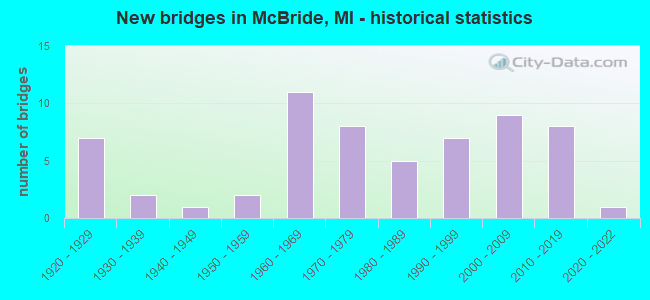
- New bridges - historical statistics
- 71920-1929
- 21930-1939
- 11940-1949
- 21950-1959
- 111960-1969
- 81970-1979
- 51980-1989
- 71990-1999
- 92000-2009
- 82010-2019
- 12020-2022

- Reconstructed bridges - Historical Statistics
- 21970-1979
- 21980-1989
- 31990-1999
- 22000-2009
- 12010-2019


- Bridge Condition - Deck
- 2.0%Excellent
- 13.7%Very good
- 39.2%Good
- 27.5%Satisfactory
- 9.8%Fair
- 7.8%Poor

- Bridge Condition - Superstructure
- 2.0%Excellent
- 19.6%Very good
- 19.6%Good
- 21.6%Satisfactory
- 27.5%Fair
- 2.0%Poor
- 3.9%Serious
- 2.0%Critical
- 2.0%Imminent failure

- Bridge Condition - Substructure
- 2.0%Excellent
- 13.7%Very good
- 27.5%Good
- 35.3%Satisfactory
- 15.7%Fair
- 3.9%Poor
- 2.0%Serious

- Bridge Condition - Channel
- 12.5%Very good
- 27.1%Good
- 35.4%Satisfactory
- 16.7%Fair
- 8.3%Poor

- Bridge Condition - Culverts
- 30.0%Very good
- 40.0%Good
- 10.0%Satisfactory
- 20.0%Fair
Find on map >> Show street view
Structure Number: 10666, Location: SEC 26-27 WELLS TWP (Lat: 43.428758, Lng: -83.266139), Route carried "on" structure: ServiceCounty highway , Year Built: 1963, Status: Posted for load, Structure Length: 0.83m (2.72ft), Average Daily Traffic: 160 (year 2009), Average Future Daily Traffic: 290 (year 2029), Design Load: H 15, Features Intersected: SUCKER CREEK DRAIN, Facility Carried by Structure: PLAIN ROAD
Minimum Vertical Clearance: 30.48m (100.00ft), Kilometerpoint: 11.383, Lanes on structure: 2, Owner: County Highway Agency, Approaching Roadway Width: 7.3m (24.0ft), Material/Design: Steel, Design/Construction: Stringer/Multi-beam, Number Of Spans In Main Unit: 1, Length of Maximum Span: 7.8m (25.6ft), Curb-To-Curb Width: 7.9m (25.9ft), Out-to-Out Width: 8.3m (27.2ft)
Condition: Deck: Good, Superstructure: Fair, Substructure: Satisfactory, Channel: Satisfactory, Operating Rating: 33.0 metric tons, Method Used To Determine Operating Rating: Load Factor (LF) rating reported by rating factor (RF) method using MS18 loading, Inventory Rating: 19.8 metric tons, Method Used To Determine Inventory Rating: Load Factor (LF) rating reported by rating factor (RF) method using MS18 loading, Structural Evaluation: Somewhat better than minimum adequacy, Deck Geometry: Somewhat better than minimum adequacy, Waterway Adequacy: Better than present minimum criteria, Approach Roadway Alignment: Equal to present desirable criteria, Bridge Posting: Required (Relationship of Operating Rating to Maximum Legal Load: 30.0 - 39.9% below), Length Of Structure Improvement: 0.82m (2.69ft), Designated Inspection Frequency: Every 12 months, Inspection Date: April 2021, Bridge Improvement Cost: $208,000, Roadway Improvement Cost: $20,000, Total Project Cost: $250,000, Deck Structure Type: Concrete Cast-file-Place, Wearing Surface/Protective System: Wearing Surface: Monolithic Concrete
Find on map >> Show street view
Structure Number: 10667, Location: SEC 32 WISNER TWP (Lat: 43.565586, Lng: -83.682647), Route carried "on" structure: ServiceCounty highway , Year Built: 1924, Year Reconstructed: 1977, Status: Posted for load, Structure Length: 1.55m (5.09ft), Average Daily Traffic: 80 (year 2009), Average Future Daily Traffic: 140 (year 2029), Design Load: H 20, Features Intersected: NORTHWEST DRAIN OUTLET 1, Facility Carried by Structure: AKRON ROAD
Minimum Vertical Clearance: 30.48m (100.00ft), Kilometerpoint: 0.016, Lanes on structure: 2, Owner: County Highway Agency, Approaching Roadway Width: 8.5m (27.9ft), Skew: 1 degrees, Material/Design: Steel, Design/Construction: Stringer/Multi-beam, Number Of Spans In Main Unit: 1, Length of Maximum Span: 14.2m (46.6ft), Curb-To-Curb Width: 6.5m (21.3ft), Out-to-Out Width: 6.6m (21.7ft)
Condition: Deck: Fair, Superstructure: Fair, Substructure: Fair, Channel: Good, Operating Rating: 35.3 metric tons, Method Used To Determine Operating Rating: Load Factor (LF) rating reported by rating factor (RF) method using MS18 loading, Inventory Rating: 21.4 metric tons, Method Used To Determine Inventory Rating: Load Factor (LF) rating reported by rating factor (RF) method using MS18 loading, Structural Evaluation: Somewhat better than minimum adequacy, Deck Geometry: Somewhat better than minimum adequacy, Waterway Adequacy: Better than present minimum criteria, Approach Roadway Alignment: Somewhat better than minimum adequacy, Bridge Posting: Required (Relationship of Operating Rating to Maximum Legal Load: 30.0 - 39.9% below), Length Of Structure Improvement: 1.58m (5.18ft), Designated Inspection Frequency: Every 24 months, Inspection Date: May 2021, Bridge Improvement Cost: $235,000, Roadway Improvement Cost: $75,000, Total Project Cost: $340,000, Deck Structure Type: Corrugated Steel, Wearing Surface/Protective System: Wearing Surface: Bituminous
Find on map >> Show street view
Structure Number: 10853, Location: 0.5 MI W OF CO LINE (Lat: 42.247622, Lng: -83.552378), Route carried "on" structure: US 12, Year Built: 1942, Year Reconstructed: 2017, Status: Open, Structure Length: 4.34m (14.24ft), Average Daily Traffic: 23,000 (year 1995), Truck Traffic: 5%, Average Future Daily Traffic: 29,882 (year 2015), Design Load: HS 20, Features Intersected: ACM TEST TRACK
Minimum Vertical Clearance: 4.27m (14.01ft), Kilometerpoint: 0.343, Lanes on structure: 4, Lanes under structure: 2, Base Highway Network: Yes (Inventory Route: 143, Subroute: 8), Owner: State Highway Agency, Approaching Roadway Width: 20.9m (68.6ft), Skew: 3 degrees, Material/Design: Steel, Design/Construction: Stringer/Multi-beam, Number Of Spans In Main Unit: 3, Length of Maximum Span: 15.8m (51.8ft), Curb-To-Curb Width: 21.5m (70.5ft), Out-to-Out Width: 22.2m (72.8ft)
Condition: Deck: Very good, Superstructure: Satisfactory, Substructure: Good, Operating Rating: 73.5 metric tons, Method Used To Determine Operating Rating: Load Factor (LF) rating reported by rating factor (RF) method using MS18 loading, Inventory Rating: 44.1 metric tons, Method Used To Determine Inventory Rating: Load Factor (LF) rating reported by rating factor (RF) method using MS18 loading, Structural Evaluation: Equal to present minimum criteria, Deck Geometry: Meets minimum limits, Underclear: High priority of corrective action, Approach Roadway Alignment: Equal to present desirable criteria, Designated Inspection Frequency: Every 24 months, Inspection Date: August 2020, Deck Structure Type: Concrete Cast-file-Place, Wearing Surface/Protective System: Wearing Surface: Monolithic Concrete, Deck Protection: Epoxy Coated Reinforcing
Find on map >> Show street view
Structure Number: 10854, Location: 1.0 MI E OF YPSILANTI (Lat: 42.231300, Lng: -83.582483), Route carried "on" structure: County highway 2006, Year Built: 1971, Year Reconstructed: 2005, Status: Open, Structure Length: 11.43m (37.50ft), Average Daily Traffic: 5,500 (year 1997), Truck Traffic: 3%, Average Future Daily Traffic: 6,325 (year 2017), Design Load: H 20, Features Intersected: I-94, Facility Carried by Structure: HARRIS RD
Minimum Vertical Clearance: 30.48m (100.00ft), Kilometerpoint: 1.117, Lanes on structure: 2, Lanes under structure: 8, Owner: State Highway Agency, Approaching Roadway Width: 9.1m (29.9ft), Material/Design: Steel, Design/Construction: Stringer/Multi-beam, Number Of Spans In Main Unit: 5, Length of Maximum Span: 42.0m (137.8ft), Curb or Sidewalk Widths: Left: 1.8m (5.9ft), Right: 1.8m (5.9ft), Curb-To-Curb Width: 10.3m (33.8ft), Out-to-Out Width: 14.7m (48.2ft)
Condition: Deck: Satisfactory, Superstructure: Satisfactory, Substructure: Satisfactory, Operating Rating: 67.7 metric tons, Method Used To Determine Operating Rating: Load Factor (LF) rating reported by rating factor (RF) method using MS18 loading, Inventory Rating: 40.5 metric tons, Method Used To Determine Inventory Rating: Load Factor (LF) rating reported by rating factor (RF) method using MS18 loading, Structural Evaluation: Equal to present minimum criteria, Deck Geometry: Meets minimum limits, Underclear: Better than present minimum criteria, Approach Roadway Alignment: Equal to present desirable criteria, Designated Inspection Frequency: Every 24 months, Other Special Inspection Frequency: Every 24 months, Inspection Date: August 2020, Other Special Inspection Date: August 2021, Bridge Improvement Cost: $1,881,000, Deck Structure Type: Concrete Cast-file-Place, Wearing Surface/Protective System: Wearing Surface: Monolithic Concrete, Deck Protection: Epoxy Coated Reinforcing
Find on map >> Show street view
Structure Number: 10962, Location: YORK TWP SEC 31 (Lat: 42.086681, Lng: -83.762033), Route carried "on" structure: County highway 8161, Year Built: 2017, Status: Open, Structure Length: 1.28m (4.20ft), Average Daily Traffic: 6,169 (year 2016), Truck Traffic: 4%, Average Future Daily Traffic: 7,093 (year 2036), Design Load: Greater than HL93, Features Intersected: MACON CREEK, Facility Carried by Structure: RIDGE ROAD
Minimum Vertical Clearance: 30.48m (100.00ft), Kilometerpoint: 0.502, Lanes on structure: 2, Owner: County Highway Agency, Approaching Roadway Width: 11.6m (38.1ft), Material/Design: Prestressed concrete, Design/Construction: Stringer/Multi-beam, Number Of Spans In Main Unit: 1, Length of Maximum Span: 12.0m (39.4ft), Curb-To-Curb Width: 11.6m (38.1ft), Out-to-Out Width: 12.5m (41.0ft)
Condition: Deck: Good, Superstructure: Very good, Substructure: Very good, Channel: Very good, Operating Rating: 97.2 metric tons, Method Used To Determine Operating Rating: Load and Resistance Factor Rating (LRFR) rating reported by rating factor(RF) method using HL-93 loadings, Inventory Rating: 79.4 metric tons, Method Used To Determine Inventory Rating: Load and Resistance Factor Rating (LRFR) rating reported by rating factor(RF) method using HL-93 loadings, Structural Evaluation: Equal to present desirable criteria, Deck Geometry: Somewhat better than minimum adequacy, Waterway Adequacy: Equal to present desirable criteria, Approach Roadway Alignment: Equal to present desirable criteria, Length Of Structure Improvement: 1.92m (6.30ft), Designated Inspection Frequency: Every 24 months, Inspection Date: November 2021, Bridge Improvement Cost: $166,000, Roadway Improvement Cost: $45,000, Total Project Cost: $230,000, Deck Structure Type: Concrete Cast-file-Place, Wearing Surface/Protective System: Wearing Surface: Monolithic Concrete, Deck Protection: Epoxy Coated Reinforcing
Find on map >> Show street view
Structure Number: 10969, Location: SHARON TWP SEC 31 (Lat: 42.167711, Lng: -84.122711), Route carried "on" structure: County highway , Year Built: 2019, Status: Open, Structure Length: 2.59m (8.50ft), Average Daily Traffic: 997 (year 2018), Truck Traffic: 11%, Average Future Daily Traffic: 1,105 (year 2038), Design Load: Greater than HL93, Features Intersected: RIVER RAISIN, Facility Carried by Structure: SHARON VALLEY ROAD
Minimum Vertical Clearance: 30.48m (100.00ft), Kilometerpoint: 0.962, Lanes on structure: 2, Owner: County Highway Agency, Approaching Roadway Width: 9.8m (32.2ft), Material/Design: Prestressed concrete, Design/Construction: Stringer/Multi-beam, Number Of Spans In Main Unit: 1, Length of Maximum Span: 24.8m (81.4ft), Curb-To-Curb Width: 9.8m (32.2ft), Out-to-Out Width: 10.5m (34.4ft)
Condition: Deck: Very good, Superstructure: Very good, Substructure: Very good, Channel: Very good, Operating Rating: 69.3 metric tons, Method Used To Determine Operating Rating: Load and Resistance Factor Rating (LRFR) rating reported by rating factor(RF) method using HL-93 loadings, Inventory Rating: 53.5 metric tons, Method Used To Determine Inventory Rating: Load and Resistance Factor Rating (LRFR) rating reported by rating factor(RF) method using HL-93 loadings, Structural Evaluation: Equal to present desirable criteria, Deck Geometry: Equal to present minimum criteria, Waterway Adequacy: Superior to present desirable criteria, Approach Roadway Alignment: Equal to present desirable criteria, Designated Inspection Frequency: Every 24 months, Inspection Date: June 2021, Bridge Improvement Cost: $350,000, Roadway Improvement Cost: $35,000, Total Project Cost: $413,000, Deck Structure Type: Concrete Cast-file-Place, Wearing Surface/Protective System: Wearing Surface: Monolithic Concrete, Deck Protection: Epoxy Coated Reinforcing
Find on map >> Show street view
Structure Number: 10997, Location: SCIO TWP SEC 21 (Lat: 42.289392, Lng: -83.838550), Route carried "on" structure: County highway 2006, Year Built: 1993, Year Reconstructed: 2002, Status: Open, Structure Length: 1.07m (3.51ft), Average Daily Traffic: 21,634 (year 2006), Truck Traffic: 10%, Average Future Daily Traffic: 39,071 (year 2026), Design Load: HS 20+Mod, Features Intersected: HONEY CREEK, Facility Carried by Structure: ZEEB ROAD
Minimum Vertical Clearance: 30.48m (100.00ft), Kilometerpoint: 10.188, Lanes on structure: 6, Owner: County Highway Agency, Approaching Roadway Width: 22.6m (74.1ft), Material/Design: Concrete, Design/Construction: Culvert, Number Of Spans In Main Unit: 2, Length of Maximum Span: 4.0m (13.1ft), Curb or Sidewalk Widths: Left: 1.5m (4.9ft), Right: 0.0m, Out-to-Out Width: 35.1m (115.2ft)
Condition: Channel: Satisfactory, Culverts: Good, Operating Rating: 54.5 metric tons, Method Used To Determine Operating Rating: Field evaluation and documented engineering judgment, Inventory Rating: 32.7 metric tons, Method Used To Determine Inventory Rating: Field evaluation and documented engineering judgment, Structural Evaluation: Better than present minimum criteria, Waterway Adequacy: Equal to present desirable criteria, Approach Roadway Alignment: Equal to present desirable criteria, Designated Inspection Frequency: Every 24 months, Inspection Date: June 2021
Find on map >> Show street view
Structure Number: 11353, Location: 1.5 MI W OF PLYMOUTH (Lat: 42.382944, Lng: -83.487511), Route carried "on" structure: State highway 14, Year Built: 1976, Year Reconstructed: 2006, Status: Open, Structure Length: 9.78m (32.09ft), Average Daily Traffic: 36,640 (year 2007), Truck Traffic: 8%, Average Future Daily Traffic: 95,000 (year 2026), Design Load: HS 25 or greater, Features Intersected: CSX RR
Minimum Vertical Clearance: 30.48m (100.00ft), Kilometerpoint: 5.672, Lanes on structure: 3, Base Highway Network: Yes (Inventory Route: 160, Subroute: 5), Owner: State Highway Agency, Approaching Roadway Width: 18.2m (59.7ft), Skew: 5 degrees, Material/Design: Steel, Design/Construction: Stringer/Multi-beam, Number Of Spans In Main Unit: 3, Length of Maximum Span: 42.8m (140.4ft), Curb or Sidewalk Widths: Left: 0.5m (1.6ft), Right: 0.5m (1.6ft), Curb-To-Curb Width: 18.4m (60.4ft), Out-to-Out Width: 19.4m (63.6ft)
Condition: Deck: Satisfactory, Superstructure: Good, Substructure: Satisfactory, Operating Rating: 79.1 metric tons, Method Used To Determine Operating Rating: Load Factor (LF) rating reported by rating factor (RF) method using MS18 loading, Inventory Rating: 47.3 metric tons, Method Used To Determine Inventory Rating: Load Factor (LF) rating reported by rating factor (RF) method using MS18 loading, Structural Evaluation: Equal to present minimum criteria, Deck Geometry: Equal to present desirable criteria, Approach Roadway Alignment: Equal to present desirable criteria, Designated Inspection Frequency: Every 24 months, Inspection Date: October 2021, Deck Structure Type: Concrete Cast-file-Place, Wearing Surface/Protective System: Wearing Surface: Latex Concrete, Deck Protection: Epoxy Coated Reinforcing
Find on map >> Show street view
Structure Number: 11986, Location: BROWNSTOWN E/MILLEVILLE (Lat: 42.052019, Lng: -83.192081), Route carried "on" structure: County highway , Year Built: 2002, Status: Open, Structure Length: 1.04m (3.41ft), Average Daily Traffic: 760 (year 2002), Truck Traffic: 2%, Average Future Daily Traffic: 760 (year 2020), Design Load: HS 20+Mod, Features Intersected: CANAL (WEST), Facility Carried by Structure: MARLEY DRIVE
Minimum Vertical Clearance: 30.48m (100.00ft), Kilometerpoint: 0.124, Lanes on structure: 2, Owner: County Highway Agency, Approaching Roadway Width: 9.1m (29.9ft), Material/Design: Concrete, Design/Construction: Culvert, Number Of Spans In Main Unit: 1, Length of Maximum Span: 9.8m (32.2ft), Curb or Sidewalk Widths: Left: 1.3m (4.3ft), Right: 1.3m (4.3ft), Curb-To-Curb Width: 7.3m (24.0ft), Out-to-Out Width: 11.0m (36.1ft)
Condition: Channel: Good, Culverts: Good, Operating Rating: 46.3 metric tons, Method Used To Determine Operating Rating: Load Factor (LF) rating reported by rating factor (RF) method using MS18 loading, Inventory Rating: 27.9 metric tons, Method Used To Determine Inventory Rating: Load Factor (LF) rating reported by rating factor (RF) method using MS18 loading, Structural Evaluation: Better than present minimum criteria, Waterway Adequacy: Equal to present desirable criteria, Approach Roadway Alignment: Equal to present minimum criteria, Designated Inspection Frequency: Every 24 months, Underwater Inspection Frequency: Every 60 months, Inspection Date: September 2020, Underwater Inspection Date: November 2018, Deck Structure Type: Concrete Cast-file-Place, Wearing Surface/Protective System: Wearing Surface: Epoxy Overlay, Membrane: Epoxy, Deck Protection: Bituminous
Find on map >> Show street view
Structure Number: 12588, Location: SECTION 27 T21N R12W (Lat: 44.179092, Lng: -85.760514), Route carried "on" structure: County highway , Year Built: 1995, Status: Open, Structure Length: 3.41m (11.19ft), Average Daily Traffic: 310 (year 2005), Average Future Daily Traffic: 560 (year 2025), Design Load: HS 20+Mod, Features Intersected: PINE RIVER, Facility Carried by Structure: NO 50 ROAD
Minimum Vertical Clearance: 30.48m (100.00ft), Kilometerpoint: 1.062, Lanes on structure: 2, Owner: County Highway Agency, Approaching Roadway Width: 7.9m (25.9ft), Skew: 1 degrees, Material/Design: Prestressed concrete, Design/Construction: Box Beam or Girders - Multiple, Number Of Spans In Main Unit: 1, Length of Maximum Span: 32.9m (107.9ft), Curb-To-Curb Width: 10.1m (33.1ft), Out-to-Out Width: 10.4m (34.1ft)
Condition: Deck: Good, Superstructure: Good, Substructure: Good, Channel: Satisfactory, Operating Rating: 74.2 metric tons, Method Used To Determine Operating Rating: Load Factor (LF) rating reported by rating factor (RF) method using MS18 loading, Inventory Rating: 35.6 metric tons, Method Used To Determine Inventory Rating: Load Factor (LF) rating reported by rating factor (RF) method using MS18 loading, Structural Evaluation: Better than present minimum criteria, Deck Geometry: Better than present minimum criteria, Waterway Adequacy: Meets minimum limits, Approach Roadway Alignment: Meets minimum limits, Designated Inspection Frequency: Every 24 months, Inspection Date: July 2020, Deck Structure Type: Concrete Cast-file-Place, Wearing Surface/Protective System: Wearing Surface: Monolithic Concrete, Deck Protection: Epoxy Coated Reinforcing
Find on map >> Show street view
Structure Number: 12674, Location: 6.5 MI S OF M-21 (Lat: 42.907206, Lng: -84.517364), Route carried "on" structure: County highway , Year Built: 1996, Status: Open, Structure Length: 8.75m (28.71ft), Average Daily Traffic: 300 (year 1995), Truck Traffic: 3%, Average Future Daily Traffic: 300 (year 2015), Design Load: HS 20, Features Intersected: US-127, Facility Carried by Structure: GREEN ROAD
Minimum Vertical Clearance: 30.48m (100.00ft), Kilometerpoint: 0.470, Lanes on structure: 2, Lanes under structure: 4, Owner: State Highway Agency, Approaching Roadway Width: 12.2m (40.0ft), Material/Design: Prestressed concrete, Design/Construction: Stringer/Multi-beam, Number Of Spans In Main Unit: 4, Length of Maximum Span: 32.5m (106.6ft), Curb-To-Curb Width: 11.6m (38.1ft), Out-to-Out Width: 12.6m (41.3ft)
Condition: Deck: Good, Superstructure: Satisfactory, Substructure: Good, Operating Rating: 73.9 metric tons, Method Used To Determine Operating Rating: Load Factor (LF) rating reported by rating factor (RF) method using MS18 loading, Inventory Rating: 38.6 metric tons, Method Used To Determine Inventory Rating: Load Factor (LF) rating reported by rating factor (RF) method using MS18 loading, Structural Evaluation: Equal to present minimum criteria, Deck Geometry: Superior to present desirable criteria, Underclear: Better than present minimum criteria, Approach Roadway Alignment: Equal to present desirable criteria, Designated Inspection Frequency: Every 24 months, Inspection Date: May 2020, Deck Structure Type: Concrete Cast-file-Place, Wearing Surface/Protective System: Wearing Surface: Monolithic Concrete, Deck Protection: Epoxy Coated Reinforcing
Find on map >> Show street view
Structure Number: 12684, Location: E OF HUNTER BLOOMFIELD TS (Lat: 42.558689, Lng: -83.216419), Route carried "on" structure: County highway 2059, Year Built: 1987, Status: Open, Structure Length: 0.70m (2.30ft), Average Daily Traffic: 200 (year 2016), Average Future Daily Traffic: 221 (year 2036), Design Load: HS 20, Features Intersected: ROUGE RIVER, Facility Carried by Structure: MANOR ROAD
Minimum Vertical Clearance: 30.48m (100.00ft), Kilometerpoint: 0.520, Lanes on structure: 2, Owner: County Highway Agency, Approaching Roadway Width: 6.0m (19.7ft), Material/Design: Prestressed concrete, Design/Construction: Box Beam or Girders - Multiple, Number Of Spans In Main Unit: 1, Length of Maximum Span: 6.1m (20.0ft), Curb-To-Curb Width: 6.0m (19.7ft), Out-to-Out Width: 7.0m (23.0ft)
Condition: Deck: Good, Superstructure: Satisfactory, Substructure: Good, Channel: Satisfactory, Operating Rating: 54.8 metric tons, Method Used To Determine Operating Rating: Load Factor (LF) rating reported by rating factor (RF) method using MS18 loading, Inventory Rating: 32.7 metric tons, Method Used To Determine Inventory Rating: Load Factor (LF) rating reported by rating factor (RF) method using MS18 loading, Structural Evaluation: Equal to present minimum criteria, Deck Geometry: High priority of corrective action, Waterway Adequacy: Equal to present minimum criteria, Approach Roadway Alignment: Equal to present minimum criteria, Designated Inspection Frequency: Every 24 months, Inspection Date: October 2020, Deck Structure Type: Concrete Precast Panels, Wearing Surface/Protective System: Wearing Surface: Bituminous, Membrane: Preformed Fabric
Find on map >> Show street view
Structure Number: 12822, Location: SEC 19 RICHLAND TWP (Lat: 42.367417, Lng: -85.527792), Route carried "on" structure: County highway , Year Built: 1998, Status: Open, Structure Length: 0.73m (2.40ft), Average Daily Traffic: 5,714 (year 2019), Truck Traffic: 6%, Average Future Daily Traffic: 14,275 (year 2027), Design Load: HS 20, Features Intersected: SPRING BROOK, Facility Carried by Structure: NORTH SPRINKLE RD
Minimum Vertical Clearance: 30.48m (100.00ft), Kilometerpoint: 22.052, Lanes on structure: 2, Base Highway Network: Yes (Inventory Route: 1, Subroute: 6), Owner: County Highway Agency, Approaching Roadway Width: 11.0m (36.1ft), Material/Design: Concrete, Design/Construction: Culvert, Number Of Spans In Main Unit: 1, Length of Maximum Span: 7.3m (24.0ft), Curb or Sidewalk Widths: Left: 0.4m (1.3ft), Right: 0.4m (1.3ft), Curb-To-Curb Width: 11.9m (39.0ft), Out-to-Out Width: 12.8m (42.0ft)
Condition: Channel: Good, Culverts: Good, Operating Rating: 59.6 metric tons, Method Used To Determine Operating Rating: Load Factor (LF), Inventory Rating: 35.7 metric tons, Method Used To Determine Inventory Rating: Load Factor (LF), Structural Evaluation: Better than present minimum criteria, Deck Geometry: Somewhat better than minimum adequacy, Waterway Adequacy: Equal to present minimum criteria, Approach Roadway Alignment: Equal to present desirable criteria, Designated Inspection Frequency: Every 24 months, Inspection Date: October 2020
Find on map >> Show street view
Structure Number: 13048, Location: KENT/OTTAWA CO LINE (Lat: 42.846156, Lng: -85.782378), Route carried "on" structure: County highway , Year Built: 2002, Status: Open, Structure Length: 7.85m (25.75ft), Average Daily Traffic: 14,000 (year 2000), Truck Traffic: 8%, Average Future Daily Traffic: 16,700 (year 2015), Design Load: HS 20, Features Intersected: M-6, Facility Carried by Structure: KENOWA AVE
Minimum Vertical Clearance: 30.48m (100.00ft), Kilometerpoint: 3.745, Lanes on structure: 2, Lanes under structure: 4, Owner: State Highway Agency, Approaching Roadway Width: 12.0m (39.4ft), Material/Design: Prestressed concrete, Design/Construction: Stringer/Multi-beam, Number Of Spans In Main Unit: 2, Length of Maximum Span: 40.7m (133.5ft), Curb-To-Curb Width: 13.2m (43.3ft), Out-to-Out Width: 14.2m (46.6ft)
Condition: Deck: Good, Superstructure: Good, Substructure: Good, Operating Rating: 62.9 metric tons, Method Used To Determine Operating Rating: Load Factor (LF) rating reported by rating factor (RF) method using MS18 loading, Inventory Rating: 37.6 metric tons, Method Used To Determine Inventory Rating: Load Factor (LF) rating reported by rating factor (RF) method using MS18 loading, Structural Evaluation: Better than present minimum criteria, Deck Geometry: Somewhat better than minimum adequacy, Underclear: Better than present minimum criteria, Approach Roadway Alignment: Superior to present desirable criteria, Designated Inspection Frequency: Every 24 months, Inspection Date: September 2021, Deck Structure Type: Concrete Cast-file-Place, Wearing Surface/Protective System: Wearing Surface: Monolithic Concrete, Deck Protection: Epoxy Coated Reinforcing
Find on map >> Show street view
Structure Number: 13209, Location: BARAGA TWP SEC 28-33 (Lat: 46.866453, Lng: -88.491772), Route carried "on" structure: County highway 786, Year Built: 2004, Status: Open, Structure Length: 0.66m (2.17ft), Average Daily Traffic: 189 (year 2014), Truck Traffic: 1%, Average Future Daily Traffic: 250 (year 2034), Design Load: HS 20+Mod, Features Intersected: KELSEY CREEK, Facility Carried by Structure: STURGEON ROAD
Minimum Vertical Clearance: 30.48m (100.00ft), Kilometerpoint: 3.607, Lanes on structure: 2, Owner: County Highway Agency, Approaching Roadway Width: 9.1m (29.9ft), Skew: 2 degrees, Material/Design: Concrete, Design/Construction: Culvert, Number Of Spans In Main Unit: 1, Length of Maximum Span: 6.1m (20.0ft)
Condition: Channel: Satisfactory, Culverts: Very good, Operating Rating: 64.8 metric tons, Method Used To Determine Operating Rating: Load Factor (LF) rating reported by rating factor (RF) method using MS18 loading, Inventory Rating: 42.1 metric tons, Method Used To Determine Inventory Rating: Load Factor (LF) rating reported by rating factor (RF) method using MS18 loading, Structural Evaluation: Equal to present desirable criteria, Waterway Adequacy: Equal to present desirable criteria, Approach Roadway Alignment: Equal to present desirable criteria, Designated Inspection Frequency: Every 24 months, Inspection Date: September 2021, Deck Structure Type: Concrete Precast Panels, Wearing Surface/Protective System: Wearing Surface: Bituminous
Find on map >> Show street view
Structure Number: 13358, Location: WAWATAM TWP SEC 32 (Lat: 45.723897, Lng: -84.830378), Route carried "on" structure: County highway , Year Built: 2006, Status: Open, Structure Length: 0.70m (2.30ft), Average Daily Traffic: 16 (year 2005), Average Future Daily Traffic: 30 (year 2025), Design Load: HS 20, Features Intersected: CARP LAKE RIVER, Facility Carried by Structure: OLIVER ROAD
Minimum Vertical Clearance: 30.48m (100.00ft), Kilometerpoint: 0.151, Lanes on structure: 1, Owner: County Highway Agency, Approaching Roadway Width: 4.3m (14.1ft), Material/Design: Wood or Timber, Design/Construction: Slab, Number Of Spans In Main Unit: 1, Length of Maximum Span: 6.7m (22.0ft), Curb or Sidewalk Widths: Left: 0.3m (1.0ft), Right: 0.3m (1.0ft), Curb-To-Curb Width: 4.6m (15.1ft), Out-to-Out Width: 5.2m (17.1ft)
Condition: Deck: Very good, Superstructure: Very good, Substructure: Good, Channel: Good, Operating Rating: 97.2 metric tons, Method Used To Determine Operating Rating: Allowable Stress (AS) rating reported by rating factor (RF) method using MS18 loading, Inventory Rating: 71.9 metric tons, Method Used To Determine Inventory Rating: Allowable Stress (AS) rating reported by rating factor (RF) method using MS18 loading, Structural Evaluation: Better than present minimum criteria, Deck Geometry: Better than present minimum criteria, Waterway Adequacy: Equal to present minimum criteria, Approach Roadway Alignment: Equal to present desirable criteria, Designated Inspection Frequency: Every 24 months, Inspection Date: August 2020, Deck Structure Type: Wood or Timber, Wearing Surface/Protective System: Wearing Surface: Bituminous, Membrane: Preformed Fabric
Find on map >> Show street view
Structure Number: 13368, Location: 0.8 MI S OF I-94 (Lat: 42.225892, Lng: -83.343433), Route carried "on" structure: ServiceOther road , Year Built: 2000, Status: Open, Structure Length: 2.61m (8.56ft), Average Daily Traffic: 13,762 (year 2011), Average Future Daily Traffic: 16,788 (year 2036), Design Load: HS 25 or greater, Features Intersected: EAST SERVICE RD, Facility Carried by Structure: NB DINGELL RD
Minimum Vertical Clearance: 30.48m (100.00ft), Kilometerpoint: 4.262, Lanes on structure: 2, Lanes under structure: 2, Owner: Local Agency, Approaching Roadway Width: 9.4m (30.8ft), Skew: 3 degrees, Material/Design: Prestressed concrete, Design/Construction: Stringer/Multi-beam, Number Of Spans In Main Unit: 1, Length of Maximum Span: 24.5m (80.4ft), Curb or Sidewalk Widths: Left: 3.0m (9.8ft), Right: 0.0m, Curb-To-Curb Width: 9.4m (30.8ft), Out-to-Out Width: 13.0m (42.7ft)
Condition: Deck: Good, Superstructure: Very good, Substructure: Good, Operating Rating: 94.3 metric tons, Method Used To Determine Operating Rating: Load Factor (LF), Inventory Rating: 47.3 metric tons, Method Used To Determine Inventory Rating: Load Factor (LF), Structural Evaluation: Better than present minimum criteria, Deck Geometry: Meets minimum limits, Underclear: Equal to present minimum criteria, Approach Roadway Alignment: Equal to present desirable criteria, Designated Inspection Frequency: Every 24 months, Inspection Date: May 2021, Deck Structure Type: Concrete Cast-file-Place, Wearing Surface/Protective System: Wearing Surface: Monolithic Concrete, Deck Protection: Epoxy Coated Reinforcing
Find on map >> Show street view
Structure Number: 13372, Location: 1.2 MI N OF EUREKA (Lat: 42.209056, Lng: -83.353528), Route carried "on" structure: Ramp Other road , Year Built: 2002, Status: Open, Structure Length: 4.26m (13.98ft), Average Daily Traffic: 3,198 (year 2011), Average Future Daily Traffic: 4,797 (year 2036), Design Load: HS 20, Features Intersected: DINGELL RD, Facility Carried by Structure: MIDFIELD RAMP C1
Minimum Vertical Clearance: 30.48m (100.00ft), Kilometerpoint: 0.060, Lanes on structure: 2, Lanes under structure: 4, Owner: Local Agency, Approaching Roadway Width: 7.9m (25.9ft), Skew: 9 degrees, Material/Design: Steel continuous, Design/Construction: Stringer/Multi-beam, Number Of Spans In Main Unit: 2, Length of Maximum Span: 25.2m (82.7ft), Curb-To-Curb Width: 9.9m (32.5ft), Out-to-Out Width: 10.9m (35.8ft)
Condition: Deck: Good, Superstructure: Good, Substructure: Good, Operating Rating: 71.5 metric tons, Method Used To Determine Operating Rating: Load Factor (LF), Inventory Rating: 42.8 metric tons, Method Used To Determine Inventory Rating: Load Factor (LF), Structural Evaluation: Better than present minimum criteria, Deck Geometry: Equal to present minimum criteria, Underclear: Somewhat better than minimum adequacy, Approach Roadway Alignment: Equal to present desirable criteria, Designated Inspection Frequency: Every 24 months, Inspection Date: May 2021, Deck Structure Type: Concrete Cast-file-Place, Wearing Surface/Protective System: Wearing Surface: Monolithic Concrete, Deck Protection: Epoxy Coated Reinforcing
Find on map >> Show street view
Structure Number: 13667, Location: 0.43 MI S OF PIERCE RD (Lat: 43.614700, Lng: -86.187600), Route carried "on" structure: Alternate County highway , Year Built: 2011, Status: Open, Structure Length: 0.69m (2.26ft), Average Daily Traffic: 600 (year 2012), Truck Traffic: 10%, Average Future Daily Traffic: 700 (year 2022), Features Intersected: OSBORN CREEK, Facility Carried by Structure: 148TH AVE
Minimum Vertical Clearance: 30.48m (100.00ft), Kilometerpoint: 3.312, Lanes on structure: 2, Owner: County Highway Agency, Approaching Roadway Width: 6.7m (22.0ft), Material/Design: Aluminum, Iron, Design/Construction: Culvert, Number Of Spans In Main Unit: 1, Length of Maximum Span: 6.7m (22.0ft)
Condition: Channel: Good, Culverts: Very good, Operating Rating: 32.4 metric tons, Method Used To Determine Operating Rating: Load and Resistance Factor Rating (LRFR) rating reported by rating factor(RF) method using HL-93 loadings, Inventory Rating: 29.2 metric tons, Method Used To Determine Inventory Rating: Load and Resistance Factor Rating (LRFR) rating reported by rating factor(RF) method using HL-93 loadings, Structural Evaluation: Better than present minimum criteria, Waterway Adequacy: Equal to present desirable criteria, Approach Roadway Alignment: Equal to present desirable criteria, Designated Inspection Frequency: Every 24 months, Inspection Date: August 2020
Find on map >> Show street view
Structure Number: 13809, Location: WATERFORD TWP SEC 15/16 (Lat: 42.664722, Lng: -83.386694), Route carried "on" structure: County highway , Year Built: 1992, Status: Open, Structure Length: 0.91m (2.99ft), Average Daily Traffic: 300 (year 2000), Average Future Daily Traffic: 345 (year 2020), Design Load: HS 20, Features Intersected: CLINTON RIVER, Facility Carried by Structure: CRESENT LAKE ROAD
Minimum Vertical Clearance: 30.48m (100.00ft), Kilometerpoint: 2.318, Lanes on structure: 2, Owner: County Highway Agency, Approaching Roadway Width: 8.2m (26.9ft), Material/Design: Steel, Design/Construction: Culvert, Number Of Spans In Main Unit: 2, Length of Maximum Span: 4.0m (13.1ft), Curb-To-Curb Width: 6.9m (22.6ft), Out-to-Out Width: 8.2m (26.9ft)
Condition: Channel: Fair, Culverts: Fair, Operating Rating: 45.4 metric tons, Method Used To Determine Operating Rating: Load Factor (LF) rating reported by rating factor (RF) method using MS18 loading, Inventory Rating: 38.6 metric tons, Method Used To Determine Inventory Rating: Load Factor (LF) rating reported by rating factor (RF) method using MS18 loading, Structural Evaluation: Somewhat better than minimum adequacy, Deck Geometry: Meets minimum limits, Waterway Adequacy: Equal to present minimum criteria, Approach Roadway Alignment: Better than present minimum criteria, Designated Inspection Frequency: Every 24 months, Inspection Date: July 2020, Wearing Surface/Protective System: Wearing Surface: Bituminous
Find on map >> Show street view
Structure Number: 13811, Location: GROVELAND TWP SEC 1 (Lat: 42.876000, Lng: -83.460028), Route carried "on" structure: County highway , Year Built: 1995, Status: Open, Structure Length: 0.79m (2.59ft), Average Daily Traffic: 340 (year 2012), Average Future Daily Traffic: 350 (year 2032), Features Intersected: KEARSLEY DRAIN, Facility Carried by Structure: COUNTY LINE ROAD
Minimum Vertical Clearance: 30.48m (100.00ft), Kilometerpoint: 0.982, Lanes on structure: 2, Owner: County Highway Agency, Approaching Roadway Width: 7.3m (24.0ft), Material/Design: Steel, Design/Construction: Culvert, Number Of Spans In Main Unit: 2, Length of Maximum Span: 3.4m (11.2ft), Curb-To-Curb Width: 8.5m (27.9ft), Out-to-Out Width: 8.8m (28.9ft)
Condition: Channel: Fair, Culverts: Fair, Operating Rating: 45.4 metric tons, Method Used To Determine Operating Rating: Load Factor (LF) rating reported by rating factor (RF) method using MS18 loading, Inventory Rating: 38.6 metric tons, Method Used To Determine Inventory Rating: Load Factor (LF) rating reported by rating factor (RF) method using MS18 loading, Structural Evaluation: Somewhat better than minimum adequacy, Deck Geometry: Equal to present minimum criteria, Waterway Adequacy: Equal to present minimum criteria, Approach Roadway Alignment: Better than present minimum criteria, Designated Inspection Frequency: Every 24 months, Inspection Date: July 2020, Wearing Surface/Protective System: Wearing Surface: Gravel
Find on map >> Show street view
Structure Number: 13812, Location: CHAMPION TWP SEC 4 (Lat: 46.754783, Lng: -87.803744), Route carried "on" structure: County highway , Year Built: 2014, Status: Open, Structure Length: 2.90m (9.51ft), Average Daily Traffic: 1,400 (year 2013), Truck Traffic: 10%, Average Future Daily Traffic: 1,450 (year 2033), Design Load: Greater than HL93, Features Intersected: SALMON TROUT RIVER, Facility Carried by Structure: AAA ROAD
Minimum Vertical Clearance: 30.48m (100.00ft), Kilometerpoint: 21.643, Lanes on structure: 2, Owner: County Highway Agency, Approaching Roadway Width: 12.2m (40.0ft), Material/Design: Prestressed concrete, Design/Construction: Stringer/Multi-beam, Number Of Spans In Main Unit: 1, Length of Maximum Span: 28.2m (92.5ft), Curb-To-Curb Width: 12.3m (40.4ft), Out-to-Out Width: 13.2m (43.3ft)
Condition: Deck: Very good, Superstructure: Very good, Substructure: Very good, Channel: Very good, Operating Rating: 97.2 metric tons, Method Used To Determine Operating Rating: Load and Resistance Factor Rating (LRFR) rating reported by rating factor(RF) method using HL-93 loadings, Inventory Rating: 70.6 metric tons, Method Used To Determine Inventory Rating: Load and Resistance Factor Rating (LRFR) rating reported by rating factor(RF) method using HL-93 loadings, Structural Evaluation: Equal to present desirable criteria, Deck Geometry: Better than present minimum criteria, Waterway Adequacy: Equal to present desirable criteria, Approach Roadway Alignment: Equal to present minimum criteria, Designated Inspection Frequency: Every 24 months, Inspection Date: October 2020, Deck Structure Type: Concrete Cast-file-Place, Wearing Surface/Protective System: Wearing Surface: Monolithic Concrete, Deck Protection: Epoxy Coated Reinforcing
Find on map >> Show street view
Structure Number: 14005, Location: 400 FT S BEAL CITY ROAD (Lat: 43.668700, Lng: -84.687883), Route carried "on" structure: County highway , Year Built: 2019, Status: Open, Structure Length: 2.01m (6.59ft), Average Daily Traffic: 100 (year 2018), Average Future Daily Traffic: 125 (year 2038), Design Load: Greater than HL93, Features Intersected: JORDON CREEK, Facility Carried by Structure: SHEPHERD ROAD
Minimum Vertical Clearance: 30.48m (100.00ft), Kilometerpoint: 22.509, Lanes on structure: 2, Owner: County Highway Agency, Approaching Roadway Width: 8.7m (28.5ft), Material/Design: Prestressed concrete, Design/Construction: Box Beam or Girders - Multiple, Number Of Spans In Main Unit: 1, Length of Maximum Span: 19.6m (64.3ft), Curb-To-Curb Width: 8.9m (29.2ft), Out-to-Out Width: 9.7m (31.8ft)
Condition: Deck: Good, Superstructure: Very good, Substructure: Very good, Channel: Good, Operating Rating: 76.1 metric tons, Method Used To Determine Operating Rating: Load and Resistance Factor Rating (LRFR) rating reported by rating factor(RF) method using HL-93 loadings, Inventory Rating: 58.6 metric tons, Method Used To Determine Inventory Rating: Load and Resistance Factor Rating (LRFR) rating reported by rating factor(RF) method using HL-93 loadings, Structural Evaluation: Equal to present desirable criteria, Deck Geometry: Better than present minimum criteria, Waterway Adequacy: Equal to present desirable criteria, Approach Roadway Alignment: Somewhat better than minimum adequacy, Designated Inspection Frequency: Every 24 months, Inspection Date: July 2021, Deck Structure Type: Concrete Cast-file-Place, Wearing Surface/Protective System: Wearing Surface: Monolithic Concrete, Deck Protection: Epoxy Coated Reinforcing