Bridge Statistics for McNair, Virginia (VA)
Condition, Traffic, Stress, Structural Evaluation, Project Costs
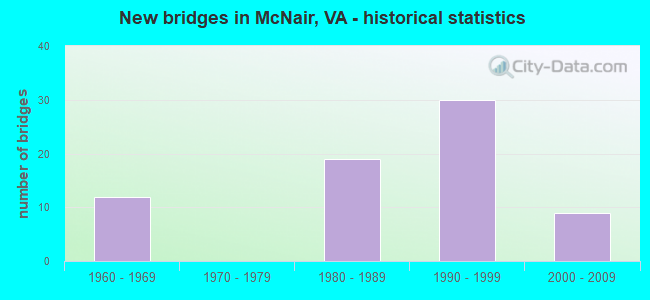
- New bridges - historical statistics
- 121960-1969
- 191980-1989
- 301990-1999
- 92000-2009

- Reconstructed bridges - Historical Statistics
- 31980-1989
- 21990-1999
- 02000-2009
- 12010-2019


- Bridge Condition - Deck
- 69.7%Good
- 27.3%Satisfactory
- 3.0%Fair

- Bridge Condition - Superstructure
- 15.2%Very good
- 57.6%Good
- 24.2%Satisfactory
- 3.0%Fair

- Bridge Condition - Substructure
- 3.0%Very good
- 57.6%Good
- 36.4%Satisfactory
- 3.0%Fair

- Bridge Condition - Channel
- 15.0%Very good
- 40.0%Good
- 40.0%Satisfactory
- 5.0%Fair

- Bridge Condition - Culverts
- 11.1%Good
- 88.9%Satisfactory
Find on map >> Show street view
Structure Number: 2100067P, Location: 1.6 MILES FROM DULLES AIR (Lat: 38.964083, Lng: -77.428528), Route carried "on" structure: State lands road , Year Built: 1994, Status: Open, Structure Length: 10.21m (33.50ft), Average Daily Traffic: 13,000 (year 2006), Average Future Daily Traffic: 15,600 (year 2026), Design Load: HS 20+Mod, Features Intersected: VA ROUTE 28, Facility Carried by Structure: DULLES ACCESS ROAD
Minimum Vertical Clearance: 30+ m (98+ ft), Kilometerpoint: 2.570, Lanes on structure: 2, Lanes under structure: 9, Owner: Metropolitan Washington Airports Service, Approaching Roadway Width: 12.1m (39.7ft), Skew: 2 degrees, Material/Design: Steel continuous, Design/Construction: Stringer/Multi-beam, Number Of Spans In Main Unit: 3, Length of Maximum Span: 39.0m (128.0ft), Curb-To-Curb Width: 12.2m (40.0ft), Out-to-Out Width: 13.3m (43.6ft)
Condition: Deck: Good, Superstructure: Good, Substructure: Good, Operating Rating: 38.1 metric tons, Method Used To Determine Operating Rating: Load and Resistance Factor (LRFR), Inventory Rating: 29.9 metric tons, Method Used To Determine Inventory Rating: Load and Resistance Factor (LRFR), Structural Evaluation: Better than present minimum criteria, Deck Geometry: Better than present minimum criteria, Underclear: Superior to present desirable criteria, Approach Roadway Alignment: Equal to present desirable criteria, Designated Inspection Frequency: Every 24 months, Inspection Date: September 2019, Deck Structure Type: Concrete Cast-file-Place, Wearing Surface/Protective System: Deck Protection: Epoxy Coated Reinforcing
Find on map >> Show street view
Structure Number: 2100068P, Location: 0.50 MILES FROM DULLES AC (Lat: 38.963561, Lng: -77.438731), Route carried "on" structure: Ramp Other road , Year Built: 1992, Status: Open, Structure Length: 1.76m (5.77ft), Average Daily Traffic: 1,000 (year 2006), Average Future Daily Traffic: 1,200 (year 2026), Features Intersected: ECONOMY PARKING CONNECTO, Facility Carried by Structure: RAMP "G"
Minimum Vertical Clearance: 30+ m (98+ ft), Kilometerpoint: 0.800, Lanes on structure: 1, Lanes under structure: 2, Owner: Metropolitan Washington Airports Service, Approaching Roadway Width: 9.1m (29.9ft), Skew: 1 degrees, Material/Design: Steel, Design/Construction: Stringer/Multi-beam, Number Of Spans In Main Unit: 1, Length of Maximum Span: 16.0m (52.5ft), Curb-To-Curb Width: 9.1m (29.9ft), Out-to-Out Width: 10.1m (33.1ft)
Condition: Deck: Good, Superstructure: Very good, Substructure: Good, Operating Rating: 54.5 metric tons, Method Used To Determine Operating Rating: Field evaluation and documented engineering judgment, Inventory Rating: 32.7 metric tons, Method Used To Determine Inventory Rating: Field evaluation and documented engineering judgment, Structural Evaluation: Better than present minimum criteria, Deck Geometry: Superior to present desirable criteria, Approach Roadway Alignment: Equal to present desirable criteria, Designated Inspection Frequency: Every 24 months, Inspection Date: September 2019, Deck Structure Type: Concrete Cast-file-Place, Wearing Surface/Protective System: Deck Protection: Epoxy Coated Reinforcing
Find on map >> Show street view
Structure Number: 6819, Location: 00.61 665 / 00.10SCL HERN (Lat: 38.952764, Lng: -77.389003), Route carried "under" structure: State highway 267, Year Built: 1989, Structure Length: 0. m, Average Daily Traffic: 99,435 (year 2008), Features Intersected: RTE 267 & DAR, Facility Carried by Structure: SBL MONROE ST.
Minimum Vertical Clearance: 5.28m (17.32ft), Kilometerpoint: 25.841, Lanes on structure: 2, Lanes under structure: 4, Toll: On toll road, Material/Design: Steel, Design/Construction: Stringer/Multi-beam, Length of Maximum Span: 21.6m (70.9ft)
Find on map >> Show street view
Structure Number: 6819, Location: 00.61 665 / 00.10SCL HERN (Lat: 38.952764, Lng: -77.389003), Route carried "under" structure: State highway 267, Year Built: 1989, Structure Length: 0. m, Average Daily Traffic: 22,000 (year 2008), Features Intersected: RTE 267 & DAR, Facility Carried by Structure: SBL MONROE ST.
Minimum Vertical Clearance: 5.13m (16.83ft), Kilometerpoint: 14.915, Lanes on structure: 2, Lanes under structure: 2, Toll: On toll road, Material/Design: Steel, Design/Construction: Stringer/Multi-beam, Length of Maximum Span: 21.6m (70.9ft)
Find on map >> Show street view
Structure Number: 6819, Location: 00.61 665 / 00.10SCL HERN (Lat: 38.952764, Lng: -77.389003), Route carried "under" structure: State highway 267, Year Built: 1989, Structure Length: 0. m, Average Daily Traffic: 22,000 (year 2008), Features Intersected: RTE 267 & DAR, Facility Carried by Structure: SBL MONROE ST.
Minimum Vertical Clearance: 5.16m (16.93ft), Kilometerpoint: 14.899, Lanes on structure: 2, Lanes under structure: 2, Toll: On toll road, Material/Design: Steel, Design/Construction: Stringer/Multi-beam, Length of Maximum Span: 21.6m (70.9ft)
Find on map >> Show street view
Structure Number: 6819, Location: 00.61 665 / 00.10SCL HERN (Lat: 38.952764, Lng: -77.389003), Route carried "under" structure: State highway 267, Year Built: 1989, Structure Length: 0. m, Average Daily Traffic: 31,200 (year 1994), Truck Traffic: 2%, Features Intersected: RTE 267 & DAR, Facility Carried by Structure: SBL MONROE ST.
Minimum Vertical Clearance: 5.23m (17.16ft), Kilometerpoint: 25.889, Lanes on structure: 2, Lanes under structure: 4, Toll: On toll road, Material/Design: Steel, Design/Construction: Stringer/Multi-beam, Length of Maximum Span: 21.6m (70.9ft)
Find on map >> Show street view
Structure Number: 11103, Location: 02.10 668 / 01.21 606 (Lat: 38.961978, Lng: -77.427397), Route carried "under" structure: 267, Year Built: 1963, Structure Length: 0. m, Average Daily Traffic: 90,632 (year 2008), Features Intersected: DULLES ACCESS RD, Facility Carried by Structure: Rte. 28 NB
Minimum Vertical Clearance: 5.56m (18.24ft), Kilometerpoint: 21.721, Lanes on structure: 4, Lanes under structure: 2, Toll: On toll road, Material/Design: Steel, Design/Construction: Stringer/Multi-beam, Length of Maximum Span: 21.6m (70.9ft)
Find on map >> Show street view
Structure Number: 11103, Location: 02.10 668 / 01.21 606 (Lat: 38.961978, Lng: -77.427397), Route carried "under" structure: Ramp State highway 267, Year Built: 1963, Structure Length: 0. m, Average Daily Traffic: 90,632 (year 2008), Features Intersected: DULLES ACCESS RD, Facility Carried by Structure: Rte. 28 NB
Minimum Vertical Clearance: 5.79m (19.00ft), Kilometerpoint: 21.722, Lanes on structure: 4, Lanes under structure: 4, Toll: On toll road, Material/Design: Steel, Design/Construction: Stringer/Multi-beam, Length of Maximum Span: 21.6m (70.9ft)
Find on map >> Show street view
Structure Number: 11103, Location: 02.10 668 / 01.21 606 (Lat: 38.961978, Lng: -77.427397), Route carried "under" structure: Other road , Year Built: 1963, Structure Length: 0. m, Average Daily Traffic: 58,285 (year 1994), Features Intersected: DULLES ACCESS RD, Facility Carried by Structure: Rte. 28 NB
Minimum Vertical Clearance: 5.23m (17.16ft), Kilometerpoint: 24.521, Lanes on structure: 4, Lanes under structure: 2, Toll: On toll road, Material/Design: Steel, Design/Construction: Stringer/Multi-beam, Length of Maximum Span: 21.6m (70.9ft)
Find on map >> Show street view
Structure Number: 11103, Location: 02.10 668 / 01.21 606 (Lat: 38.961978, Lng: -77.427397), Route carried "under" structure: State highway , Year Built: 1963, Structure Length: 0. m, Average Daily Traffic: 90,632 (year 2008), Features Intersected: DULLES ACCESS RD, Facility Carried by Structure: Rte. 28 NB
Minimum Vertical Clearance: 5.41m (17.75ft), Kilometerpoint: 21.722, Lanes on structure: 4, Lanes under structure: 2, Toll: On toll road, Material/Design: Steel, Design/Construction: Stringer/Multi-beam, Length of Maximum Span: 21.6m (70.9ft)
Find on map >> Show street view
Structure Number: 11108, Location: 02.10FR668 / 01.21TO606 (Lat: 38.962000, Lng: -77.427631), Route carried "under" structure: State highway , Year Built: 1988, Structure Length: 0. m, Average Daily Traffic: 10,000 (year 1994), Features Intersected: DULLES ACCESS ROAD, Facility Carried by Structure: Rte. 28 SB
Minimum Vertical Clearance: 5.08m (16.67ft), Kilometerpoint: 0.000, Lanes on structure: 4, Lanes under structure: 2, Material/Design: Steel, Design/Construction: Stringer/Multi-beam, Length of Maximum Span: 23.5m (77.1ft)
Find on map >> Show street view
Structure Number: 11108, Location: 02.10FR668 / 01.21TO606 (Lat: 38.962000, Lng: -77.427631), Route carried "under" structure: State highway 267, Year Built: 1988, Structure Length: 0. m, Average Daily Traffic: 10,000 (year 1994), Features Intersected: DULLES ACCESS ROAD, Facility Carried by Structure: Rte. 28 SB
Minimum Vertical Clearance: 5.39m (17.68ft), Kilometerpoint: 0.000, Lanes on structure: 4, Lanes under structure: 2, Material/Design: Steel, Design/Construction: Stringer/Multi-beam, Length of Maximum Span: 23.5m (77.1ft)
Find on map >> Show street view
Structure Number: 11108, Location: 02.10FR668 / 01.21TO606 (Lat: 38.962000, Lng: -77.427631), Route carried "under" structure: State highway 267, Year Built: 1988, Structure Length: 0. m, Average Daily Traffic: 10,000 (year 1994), Features Intersected: DULLES ACCESS ROAD, Facility Carried by Structure: Rte. 28 SB
Minimum Vertical Clearance: 5.92m (19.42ft), Kilometerpoint: 0.000, Lanes on structure: 4, Lanes under structure: 4, Material/Design: Steel, Design/Construction: Stringer/Multi-beam, Length of Maximum Span: 23.5m (77.1ft)
Find on map >> Show street view
Structure Number: 11108, Location: 02.10FR668 / 01.21TO606 (Lat: 38.962000, Lng: -77.427631), Route carried "under" structure: State highway , Year Built: 1988, Structure Length: 0. m, Average Daily Traffic: 10,000 (year 1994), Features Intersected: DULLES ACCESS ROAD, Facility Carried by Structure: Rte. 28 SB
Minimum Vertical Clearance: 5.28m (17.32ft), Kilometerpoint: 0.000, Lanes on structure: 4, Lanes under structure: 2, Material/Design: Steel, Design/Construction: Stringer/Multi-beam, Length of Maximum Span: 23.5m (77.1ft)
Find on map >> Show street view
Structure Number: 23873, Location: 00.60FR28/00.50TO DAAR (Lat: 38.963936, Lng: -77.427381), Route carried "under" structure: State highway 28, Year Built: 1994, Structure Length: 0. m, Average Daily Traffic: 25,500 (year 1994), Features Intersected: SULLY ROAD AND RAMP F, Facility Carried by Structure: SULLY RD. (RAMP A)
Minimum Vertical Clearance: 5.79m (19.00ft), Kilometerpoint: 0.000, Lanes on structure: 2, Lanes under structure: 5, Material/Design: Steel continuous, Design/Construction: Stringer/Multi-beam, Length of Maximum Span: 39.0m (128.0ft)
Find on map >> Show street view
Structure Number: 23873, Location: 00.60FR28/00.50TO DAAR (Lat: 38.963936, Lng: -77.427381), Route carried "under" structure: State highway 28, Year Built: 1994, Structure Length: 0. m, Average Daily Traffic: 25,500 (year 1994), Features Intersected: SULLY ROAD AND RAMP F, Facility Carried by Structure: SULLY RD. (RAMP A)
Minimum Vertical Clearance: 5.41m (17.75ft), Kilometerpoint: 0.000, Lanes on structure: 2, Lanes under structure: 4, Material/Design: Steel continuous, Design/Construction: Stringer/Multi-beam, Length of Maximum Span: 39.0m (128.0ft)
Find on map >> Show street view
Structure Number: 23873, Location: 00.60FR28/00.50TO DAAR (Lat: 38.963936, Lng: -77.427381), Route carried "under" structure: Ramp State highway 28, Year Built: 1994, Structure Length: 0. m, Average Daily Traffic: 5,000 (year 1994), Features Intersected: SULLY ROAD AND RAMP F, Facility Carried by Structure: SULLY RD. (RAMP A)
Minimum Vertical Clearance: 6.38m (20.93ft), Kilometerpoint: 0.000, Lanes on structure: 2, Lanes under structure: 1, Material/Design: Steel continuous, Design/Construction: Stringer/Multi-beam, Length of Maximum Span: 39.0m (128.0ft)
Find on map >> Show street view
Structure Number: 23879, Location: 00.30FR28/00.60TO DAAR (Lat: 38.962817, Lng: -77.425294), Route carried "under" structure: Other road 267, Year Built: 1994, Structure Length: 0. m, Average Daily Traffic: 10,000 (year 1994), Features Intersected: RTE.267 CD; EB & WB DAAR, Facility Carried by Structure: SULLY RD. (RAMP A)
Minimum Vertical Clearance: 5.08m (16.67ft), Kilometerpoint: 0.290, Lanes on structure: 2, Lanes under structure: 2, Toll: On toll road, Material/Design: Steel continuous, Design/Construction: Stringer/Multi-beam, Length of Maximum Span: 49.1m (161.1ft)
Find on map >> Show street view
Structure Number: 23879, Location: 00.30FR28/00.60TO DAAR (Lat: 38.962817, Lng: -77.425294), Route carried "under" structure: Other road , Year Built: 1994, Structure Length: 0. m, Average Daily Traffic: 15,000 (year 1994), Features Intersected: RTE.267 CD; EB & WB DAAR, Facility Carried by Structure: SULLY RD. (RAMP A)
Minimum Vertical Clearance: 5.49m (18.01ft), Kilometerpoint: 0.000, Lanes on structure: 2, Lanes under structure: 3, Material/Design: Steel continuous, Design/Construction: Stringer/Multi-beam, Length of Maximum Span: 49.1m (161.1ft)
Find on map >> Show street view
Structure Number: 23879, Location: 00.30FR28/00.60TO DAAR (Lat: 38.962817, Lng: -77.425294), Route carried "under" structure: Other road , Year Built: 1994, Structure Length: 0. m, Average Daily Traffic: 15,000 (year 1994), Features Intersected: RTE.267 CD; EB & WB DAAR, Facility Carried by Structure: SULLY RD. (RAMP A)
Minimum Vertical Clearance: 6.45m (21.16ft), Kilometerpoint: 0.000, Lanes on structure: 2, Lanes under structure: 3, Material/Design: Steel continuous, Design/Construction: Stringer/Multi-beam, Length of Maximum Span: 49.1m (161.1ft)
Find on map >> Show street view
Structure Number: 24101, Location: 02.60FR606/01.40TO657 (Lat: 38.965525, Lng: -77.428961), Route carried "under" structure: Other road 28, Year Built: 1995, Structure Length: 0. m, Average Daily Traffic: 22,000 (year 1994), Truck Traffic: 5%, Features Intersected: SULLY ROAD (RTE. 28), Facility Carried by Structure: DULLES GREENWAY WB
Minimum Vertical Clearance: 5.79m (19.00ft), Kilometerpoint: 63.620, Lanes on structure: 2, Lanes under structure: 6, Toll: On toll road, Material/Design: Steel continuous, Design/Construction: Stringer/Multi-beam, Length of Maximum Span: 65.2m (213.9ft)
Find on map >> Show street view
Structure Number: 24101, Location: 02.60FR606/01.40TO657 (Lat: 38.965525, Lng: -77.428961), Route carried "under" structure: State highway 28, Year Built: 1995, Structure Length: 0. m, Average Daily Traffic: 111,095 (year 2008), Truck Traffic: 2%, Features Intersected: SULLY ROAD (RTE. 28), Facility Carried by Structure: DULLES GREENWAY WB
Minimum Vertical Clearance: 5.92m (19.42ft), Kilometerpoint: 63.620, Lanes on structure: 2, Lanes under structure: 4, Material/Design: Steel continuous, Design/Construction: Stringer/Multi-beam, Length of Maximum Span: 65.2m (213.9ft)
Find on map >> Show street view
Structure Number: 24103, Location: 02.60FR606/01.40TO657 (Lat: 38.964989, Lng: -77.428647), Route carried "under" structure: State highway 28, Year Built: 1995, Structure Length: 0. m, Average Daily Traffic: 111,095 (year 2008), Truck Traffic: 2%, Features Intersected: SULLY ROAD (ROUTE 28), Facility Carried by Structure: DULLES GREENWAY EB
Minimum Vertical Clearance: 6.68m (21.92ft), Kilometerpoint: 63.604, Lanes on structure: 2, Lanes under structure: 6, Material/Design: Steel continuous, Design/Construction: Stringer/Multi-beam, Length of Maximum Span: 65.2m (213.9ft)
Find on map >> Show street view
Structure Number: 24103, Location: 02.60FR606/01.40TO657 (Lat: 38.964989, Lng: -77.428647), Route carried "under" structure: State highway 28, Year Built: 1995, Structure Length: 0. m, Average Daily Traffic: 22,000 (year 1994), Truck Traffic: 5%, Features Intersected: SULLY ROAD (ROUTE 28), Facility Carried by Structure: DULLES GREENWAY EB
Minimum Vertical Clearance: 6.22m (20.41ft), Kilometerpoint: 0.000, Lanes on structure: 2, Lanes under structure: 4, Material/Design: Steel continuous, Design/Construction: Stringer/Multi-beam, Length of Maximum Span: 65.2m (213.9ft)
Find on map >> Show street view
Structure Number: 24603, Location: 00.15FR28NB/02.35TO606 (Lat: 38.968750, Lng: -77.429317), Route carried "under" structure: State highway 28, Year Built: 1995, Structure Length: 0. m, Average Daily Traffic: 47,273 (year 2018), Truck Traffic: 3%, Features Intersected: SULLY ROAD SBL (RTE. 28), Facility Carried by Structure: D. GREENWAY RAMP I
Minimum Vertical Clearance: 5.64m (18.50ft), Kilometerpoint: 0.000, Lanes on structure: 1, Lanes under structure: 4, Material/Design: Steel continuous, Design/Construction: Stringer/Multi-beam, Length of Maximum Span: 54.6m (179.1ft)
Find on map >> Show street view
Structure Number: 24604, Location: 03.00FR606/01.10TO657 (Lat: 38.962822, Lng: -77.424325), Route carried "under" structure: Other road , Year Built: 1995, Structure Length: 0. m, Average Daily Traffic: 11,500 (year 1996), Truck Traffic: 3%, Features Intersected: EBL 267 CD; RAMP B; DAAR, Facility Carried by Structure: DULLES GREENWAY EB
Minimum Vertical Clearance: 5.79m (19.00ft), Kilometerpoint: 0.000, Lanes on structure: 2, Lanes under structure: 3, Material/Design: Steel continuous, Design/Construction: Stringer/Multi-beam, Length of Maximum Span: 71.9m (235.9ft)
Find on map >> Show street view
Structure Number: 24604, Location: 03.00FR606/01.10TO657 (Lat: 38.962822, Lng: -77.424325), Route carried "under" structure: Other road , Year Built: 1995, Structure Length: 0. m, Average Daily Traffic: 20,000 (year 1994), Truck Traffic: 2%, Features Intersected: EBL 267 CD; RAMP B; DAAR, Facility Carried by Structure: DULLES GREENWAY EB
Minimum Vertical Clearance: 5.77m (18.93ft), Kilometerpoint: 0.000, Lanes on structure: 2, Lanes under structure: 3, Material/Design: Steel continuous, Design/Construction: Stringer/Multi-beam, Length of Maximum Span: 71.9m (235.9ft)
Find on map >> Show street view
Structure Number: 24604, Location: 03.00FR606/01.10TO657 (Lat: 38.962822, Lng: -77.424325), Route carried "under" structure: Other road 267, Year Built: 1995, Structure Length: 0. m, Average Daily Traffic: 11,500 (year 1996), Truck Traffic: 3%, Features Intersected: EBL 267 CD; RAMP B; DAAR, Facility Carried by Structure: DULLES GREENWAY EB
Minimum Vertical Clearance: 5.64m (18.50ft), Kilometerpoint: 0.322, Lanes on structure: 2, Lanes under structure: 3, Toll: On toll road, Material/Design: Steel continuous, Design/Construction: Stringer/Multi-beam, Length of Maximum Span: 71.9m (235.9ft)
Find on map >> Show street view
Structure Number: 28572, Location: 00.40FR605/00.02TO28 (Lat: 38.948306, Lng: -77.429972), Route carried "under" structure: State highway 28, Year Built: 2007, Structure Length: 0. m, Average Daily Traffic: 40,000 (year 2010), Truck Traffic: 1%, Features Intersected: RTE.28 SULLY RD., Facility Carried by Structure: FRYING PAN RD.
Minimum Vertical Clearance: 5.61m (18.41ft), Kilometerpoint: 0.000, Lanes on structure: 3, Lanes under structure: 5, Material/Design: Steel continuous, Design/Construction: Stringer/Multi-beam, Length of Maximum Span: 39.0m (128.0ft)
Find on map >> Show street view
Structure Number: 28572, Location: 00.40FR605/00.02TO28 (Lat: 38.948306, Lng: -77.429972), Route carried "under" structure: State highway 28, Year Built: 2007, Structure Length: 0. m, Average Daily Traffic: 40,000 (year 2010), Truck Traffic: 1%, Features Intersected: RTE.28 SULLY RD., Facility Carried by Structure: FRYING PAN RD.
Minimum Vertical Clearance: 5.43m (17.81ft), Kilometerpoint: 0.000, Lanes on structure: 3, Lanes under structure: 4, Material/Design: Steel continuous, Design/Construction: Stringer/Multi-beam, Length of Maximum Span: 39.0m (128.0ft)