Bridge Statistics for McPherson, Kansas (KS)
Condition, Traffic, Stress, Structural Evaluation, Project Costs
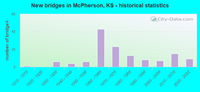
- New bridges - historical statistics
- 11910-1919
- 61930-1939
- 41940-1949
- 61950-1959
- 431960-1969
- 231970-1979
- 131980-1989
- 81990-1999
- 72000-2009
- 152010-2019
- 92020-2022
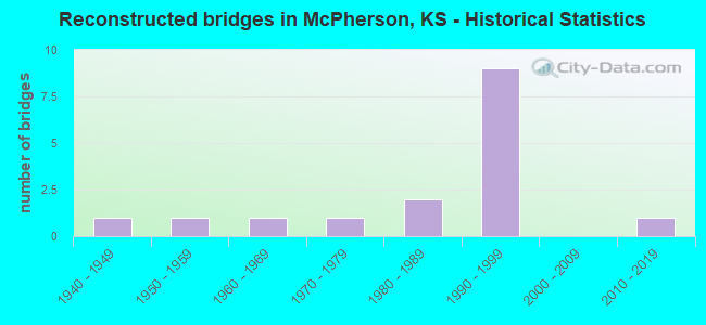
- Reconstructed bridges - Historical Statistics
- 11940-1949
- 11950-1959
- 11960-1969
- 11970-1979
- 21980-1989
- 91990-1999
- 02000-2009
- 12010-2019
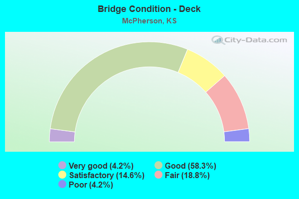
- Bridge Condition - Deck
- 4.2%Very good
- 58.3%Good
- 14.6%Satisfactory
- 18.8%Fair
- 4.2%Poor
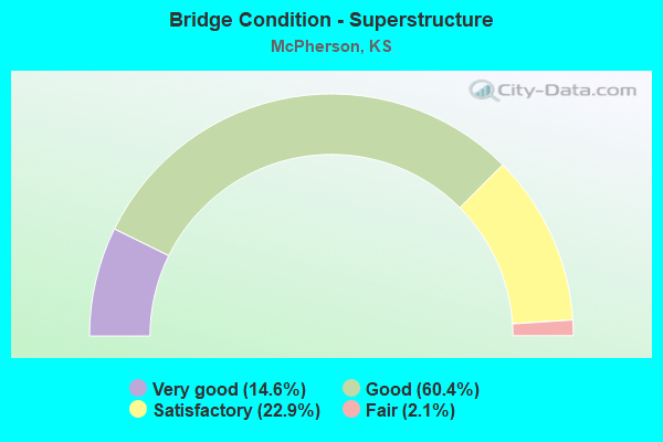
- Bridge Condition - Superstructure
- 14.6%Very good
- 60.4%Good
- 22.9%Satisfactory
- 2.1%Fair
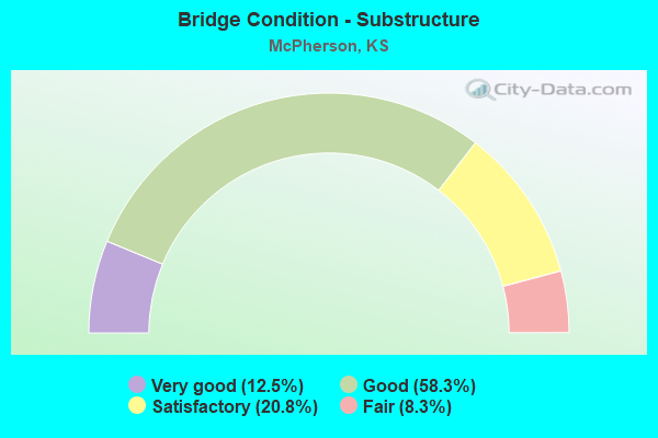
- Bridge Condition - Substructure
- 12.5%Very good
- 58.3%Good
- 20.8%Satisfactory
- 8.3%Fair
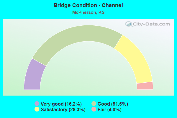
- Bridge Condition - Channel
- 16.2%Very good
- 51.5%Good
- 28.3%Satisfactory
- 4.0%Fair
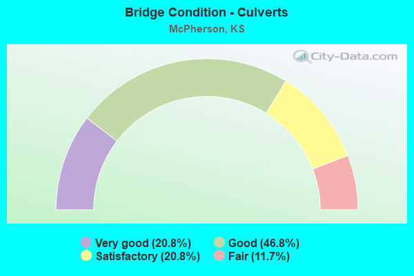
- Bridge Condition - Culverts
- 20.8%Very good
- 46.8%Good
- 20.8%Satisfactory
- 11.7%Fair
Find on map >> Show street view
Structure Number: 999905600591111, Location: 2.06 MI E I135 (Lat: 38.376667, Lng: -97.584444), Route carried "on" structure: US 56, Year Built: 1988, Status: Open, Structure Length: 2.88m (9.45ft), Average Daily Traffic: 6,200 (year 2020), Truck Traffic: 16%, Average Future Daily Traffic: 8,686 (year 2041), Design Load: H 20, Features Intersected: TURKEY CREEK
Minimum Vertical Clearance: 30.47m (99.97ft), Kilometerpoint: 30.214, Lanes on structure: 2, Base Highway Network: Yes, Owner: State Highway Agency, Approaching Roadway Width: 13.4m (44.0ft), Material/Design: Concrete, Design/Construction: Culvert, Number Of Spans In Main Unit: 9, Length of Maximum Span: 3.0m (9.8ft), Curb-To-Curb Width: 13.4m (44.0ft), Out-to-Out Width: 26.1m (85.6ft)
Condition: Channel: Satisfactory, Culverts: Good, Operating Rating: 38.3 metric tons, Method Used To Determine Operating Rating: Load Factor (LF), Inventory Rating: 23.0 metric tons, Method Used To Determine Inventory Rating: Load Factor (LF), Structural Evaluation: Somewhat better than minimum adequacy, Deck Geometry: Equal to present minimum criteria, Waterway Adequacy: Somewhat better than minimum adequacy, Approach Roadway Alignment: Equal to present desirable criteria, Length Of Structure Improvement: 9.46m (31.04ft), Designated Inspection Frequency: Every 24 months, Inspection Date: November 2021, Deck Structure Type: Concrete Cast-file-Place, Wearing Surface/Protective System: Wearing Surface: Bituminous
Find on map >> Show street view
Structure Number: 999905600591191, Location: 13.00 MI E RICE COLN (Lat: 38.369444, Lng: -97.688611), Route carried "on" structure: US 56, Year Built: 1997, Status: Open, Structure Length: 2.62m (8.60ft), Average Daily Traffic: 4,070 (year 2020), Truck Traffic: 20%, Average Future Daily Traffic: 5,065 (year 2041), Design Load: HS 20, Features Intersected: BULL CREEK
Minimum Vertical Clearance: 30.47m (99.97ft), Kilometerpoint: 20.925, Lanes on structure: 2, Base Highway Network: Yes, Owner: State Highway Agency, Approaching Roadway Width: 13.4m (44.0ft), Material/Design: Concrete, Design/Construction: Culvert, Number Of Spans In Main Unit: 8, Length of Maximum Span: 3.0m (9.8ft), Curb-To-Curb Width: 13.4m (44.0ft), Out-to-Out Width: 18.4m (60.4ft)
Condition: Channel: Satisfactory, Culverts: Good, Operating Rating: 92.5 metric tons, Method Used To Determine Operating Rating: Load Factor (LF), Inventory Rating: 55.3 metric tons, Method Used To Determine Inventory Rating: Load Factor (LF), Structural Evaluation: Better than present minimum criteria, Deck Geometry: Better than present minimum criteria, Waterway Adequacy: Meets minimum limits, Approach Roadway Alignment: Meets minimum limits, Length Of Structure Improvement: 8.60m (28.22ft), Designated Inspection Frequency: Every 24 months, Inspection Date: November 2021, Deck Structure Type: Concrete Cast-file-Place, Wearing Surface/Protective System: Wearing Surface: Bituminous
Find on map >> Show street view
Structure Number: 999906100590991, Location: JCT K153SPUR/K61, NB (Lat: 38.333611, Lng: -97.671389), Route carried "on" structure: State highway 61, Year Built: 1969, Status: Open, Structure Length: 4.90m (16.08ft), Average Daily Traffic: 4,270 (year 2020), Truck Traffic: 12%, Average Future Daily Traffic: 6,729 (year 2041), Design Load: H 20, Features Intersected: K153SPUR, OLD US81
Minimum Vertical Clearance: 30.47m (99.97ft), Kilometerpoint: 23.273, Lanes on structure: 3, Lanes under structure: 3, Base Highway Network: Yes, Owner: State Highway Agency, Approaching Roadway Width: 12.2m (40.0ft), Skew: 2 degrees, Material/Design: Steel continuous, Design/Construction: Stringer/Multi-beam, Number Of Spans In Main Unit: 3, Length of Maximum Span: 19.2m (63.0ft), Curb-To-Curb Width: 14.6m (47.9ft), Out-to-Out Width: 15.2m (49.9ft)
Condition: Deck: Fair, Superstructure: Satisfactory, Substructure: Good, Operating Rating: 44.5 metric tons, Method Used To Determine Operating Rating: Load Factor (LF), Inventory Rating: 26.3 metric tons, Method Used To Determine Inventory Rating: Load Factor (LF), Structural Evaluation: Equal to present minimum criteria, Deck Geometry: Somewhat better than minimum adequacy, Underclear: Somewhat better than minimum adequacy, Approach Roadway Alignment: Equal to present desirable criteria, Length Of Structure Improvement: 16.08m (52.76ft), Designated Inspection Frequency: Every 24 months, Inspection Date: November 2021, Deck Structure Type: Concrete Cast-file-Place, Wearing Surface/Protective System: Wearing Surface: Low Slump Concrete
Find on map >> Show street view
Structure Number: 999906100591001, Location: 0.19 MI E K153SPUR, SB (Lat: 38.335000, Lng: -97.668333), Route carried "on" structure: State highway 61, Year Built: 1969, Status: Open, Structure Length: 3.55m (11.65ft), Average Daily Traffic: 4,270 (year 2020), Truck Traffic: 12%, Average Future Daily Traffic: 6,997 (year 2041), Design Load: H 20, Features Intersected: UP RAILROAD
Minimum Vertical Clearance: 30.47m (99.97ft), Kilometerpoint: 23.633, Lanes on structure: 2, Base Highway Network: Yes, Owner: State Highway Agency, Approaching Roadway Width: 12.2m (40.0ft), Skew: 1 degrees, Material/Design: Steel continuous, Design/Construction: Stringer/Multi-beam, Number Of Spans In Main Unit: 3, Length of Maximum Span: 13.7m (44.9ft), Curb-To-Curb Width: 12.2m (40.0ft), Out-to-Out Width: 12.8m (42.0ft)
Condition: Deck: Fair, Superstructure: Good, Substructure: Good, Operating Rating: 47.2 metric tons, Method Used To Determine Operating Rating: Load Factor (LF), Inventory Rating: 28.1 metric tons, Method Used To Determine Inventory Rating: Load Factor (LF), Structural Evaluation: Better than present minimum criteria, Deck Geometry: Better than present minimum criteria, Underclear: Equal to present minimum criteria, Approach Roadway Alignment: Equal to present desirable criteria, Length Of Structure Improvement: 11.66m (38.25ft), Designated Inspection Frequency: Every 24 months, Inspection Date: November 2021, Deck Structure Type: Concrete Cast-file-Place, Wearing Surface/Protective System: Wearing Surface: Low Slump Concrete
Find on map >> Show street view
Structure Number: 999906100591011, Location: 0.20 MI E K153SPUR, NB (Lat: 38.334722, Lng: -97.668056), Route carried "on" structure: State highway 61, Year Built: 1969, Status: Open, Structure Length: 3.55m (11.65ft), Average Daily Traffic: 4,270 (year 2020), Truck Traffic: 12%, Average Future Daily Traffic: 6,997 (year 2041), Design Load: H 20, Features Intersected: UP RAILROAD
Minimum Vertical Clearance: 30.47m (99.97ft), Kilometerpoint: 23.585, Lanes on structure: 2, Base Highway Network: Yes, Owner: State Highway Agency, Approaching Roadway Width: 12.2m (40.0ft), Skew: 1 degrees, Material/Design: Steel continuous, Design/Construction: Stringer/Multi-beam, Number Of Spans In Main Unit: 3, Length of Maximum Span: 13.7m (44.9ft), Curb-To-Curb Width: 12.2m (40.0ft), Out-to-Out Width: 12.8m (42.0ft)
Condition: Deck: Fair, Superstructure: Satisfactory, Substructure: Satisfactory, Operating Rating: 46.3 metric tons, Method Used To Determine Operating Rating: Load Factor (LF), Inventory Rating: 27.2 metric tons, Method Used To Determine Inventory Rating: Load Factor (LF), Structural Evaluation: Equal to present minimum criteria, Deck Geometry: Better than present minimum criteria, Underclear: Better than present minimum criteria, Approach Roadway Alignment: Equal to present desirable criteria, Length Of Structure Improvement: 11.66m (38.25ft), Designated Inspection Frequency: Every 24 months, Inspection Date: November 2021, Deck Structure Type: Concrete Cast-file-Place, Wearing Surface/Protective System: Wearing Surface: Low Slump Concrete
Find on map >> Show street view
Structure Number: 999906100591021, Location: JCT US-81 ALT/K-61 SB (Lat: 38.335278, Lng: -97.666944), Route carried "on" structure: State highway 61, Year Built: 1969, Status: Open, Structure Length: 4.59m (15.06ft), Average Daily Traffic: 4,270 (year 2020), Truck Traffic: 12%, Average Future Daily Traffic: 6,997 (year 2041), Design Load: H 20, Features Intersected: RS0305 RT, US81 ALT
Minimum Vertical Clearance: 30.47m (99.97ft), Kilometerpoint: 23.743, Lanes on structure: 2, Lanes under structure: 2, Base Highway Network: Yes, Owner: State Highway Agency, Approaching Roadway Width: 12.2m (40.0ft), Skew: 2 degrees, Material/Design: Steel continuous, Design/Construction: Stringer/Multi-beam, Number Of Spans In Main Unit: 3, Length of Maximum Span: 17.2m (56.4ft), Curb-To-Curb Width: 12.2m (40.0ft), Out-to-Out Width: 12.8m (42.0ft)
Condition: Deck: Poor, Superstructure: Good, Substructure: Good, Operating Rating: 55.3 metric tons, Method Used To Determine Operating Rating: Load Factor (LF), Inventory Rating: 33.6 metric tons, Method Used To Determine Inventory Rating: Load Factor (LF), Structural Evaluation: Better than present minimum criteria, Deck Geometry: Better than present minimum criteria, Underclear: Equal to present desirable criteria, Approach Roadway Alignment: Equal to present desirable criteria, Length Of Structure Improvement: 15.06m (49.41ft), Designated Inspection Frequency: Every 12 months, Inspection Date: November 2021, Deck Structure Type: Concrete Cast-file-Place, Wearing Surface/Protective System: Wearing Surface: Low Slump Concrete
Find on map >> Show street view
Structure Number: 999906100591031, Location: JCT US-81 ALT/K-61 NB (Lat: 38.335000, Lng: -97.666944), Route carried "on" structure: State highway 61, Year Built: 1969, Status: Open, Structure Length: 4.59m (15.06ft), Average Daily Traffic: 4,270 (year 2020), Truck Traffic: 12%, Average Future Daily Traffic: 6,997 (year 2041), Design Load: H 20, Features Intersected: RS0305 RT, US81 ALT
Minimum Vertical Clearance: 30.47m (99.97ft), Kilometerpoint: 23.677, Lanes on structure: 2, Lanes under structure: 2, Base Highway Network: Yes, Owner: State Highway Agency, Approaching Roadway Width: 12.2m (40.0ft), Skew: 2 degrees, Material/Design: Steel continuous, Design/Construction: Stringer/Multi-beam, Number Of Spans In Main Unit: 3, Length of Maximum Span: 17.2m (56.4ft), Curb-To-Curb Width: 12.2m (40.0ft), Out-to-Out Width: 12.8m (42.0ft)
Condition: Deck: Fair, Superstructure: Satisfactory, Substructure: Satisfactory, Operating Rating: 57.2 metric tons, Method Used To Determine Operating Rating: Load Factor (LF), Inventory Rating: 34.5 metric tons, Method Used To Determine Inventory Rating: Load Factor (LF), Structural Evaluation: Equal to present minimum criteria, Deck Geometry: Better than present minimum criteria, Underclear: Equal to present desirable criteria, Approach Roadway Alignment: Equal to present desirable criteria, Length Of Structure Improvement: 15.06m (49.41ft), Designated Inspection Frequency: Every 24 months, Inspection Date: November 2021, Deck Structure Type: Concrete Cast-file-Place, Wearing Surface/Protective System: Wearing Surface: Low Slump Concrete
Find on map >> Show street view
Structure Number: 999906100591351, Location: K153/K61 (Lat: 38.327222, Lng: -97.696389), Route carried "on" structure: State highway 61, Year Built: 2010, Status: Open, Structure Length: 13.14m (43.11ft), Average Daily Traffic: 3,235 (year 2020), Truck Traffic: 13%, Average Future Daily Traffic: 5,098 (year 2041), Design Load: HL 93, Features Intersected: K153 HWY AND UP RR
Minimum Vertical Clearance: 30.47m (99.97ft), Kilometerpoint: 20.942, Lanes on structure: 2, Lanes under structure: 1, Base Highway Network: Yes, Owner: State Highway Agency, Approaching Roadway Width: 12.2m (40.0ft), Skew: 4 degrees, Material/Design: Steel continuous, Design/Construction: Stringer/Multi-beam, Number Of Spans In Main Unit: 4, Length of Maximum Span: 37.2m (122.0ft), Curb-To-Curb Width: 12.2m (40.0ft), Out-to-Out Width: 13.0m (42.7ft)
Condition: Deck: Good, Superstructure: Very good, Substructure: Very good, Operating Rating: 52.5 metric tons, Method Used To Determine Operating Rating: Load and Resistance Factor Rating (LRFR) rating reported by rating factor(RF) method using HL-93 loadings, Inventory Rating: 40.5 metric tons, Method Used To Determine Inventory Rating: Load and Resistance Factor Rating (LRFR) rating reported by rating factor(RF) method using HL-93 loadings, Structural Evaluation: Equal to present desirable criteria, Deck Geometry: Better than present minimum criteria, Underclear: High priority of corrective action, Approach Roadway Alignment: Equal to present desirable criteria, Length Of Structure Improvement: 43.10m (141.40ft), Designated Inspection Frequency: Every 24 months, Inspection Date: November 2021, Wearing Surface/Protective System: Wearing Surface: Low Slump Concrete, Deck Protection: Epoxy Coated Reinforcing
Find on map >> Show street view
Structure Number: 999906100591361, Location: 0.59 MI NE JCT K153/K61 (Lat: 38.327500, Lng: -97.695833), Route carried "on" structure: State highway 61, Year Built: 2010, Status: Open, Structure Length: 13.14m (43.11ft), Average Daily Traffic: 3,235 (year 2020), Truck Traffic: 13%, Average Future Daily Traffic: 5,098 (year 2041), Design Load: HL 93, Features Intersected: K153 HWY AND UP RR
Minimum Vertical Clearance: 30.47m (99.97ft), Kilometerpoint: 21.042, Lanes on structure: 2, Lanes under structure: 1, Base Highway Network: Yes, Owner: State Highway Agency, Approaching Roadway Width: 12.2m (40.0ft), Skew: 4 degrees, Material/Design: Steel continuous, Design/Construction: Stringer/Multi-beam, Number Of Spans In Main Unit: 4, Length of Maximum Span: 37.2m (122.0ft), Curb-To-Curb Width: 12.2m (40.0ft), Out-to-Out Width: 13.0m (42.7ft)
Condition: Deck: Good, Superstructure: Very good, Substructure: Very good, Operating Rating: 52.5 metric tons, Method Used To Determine Operating Rating: Load and Resistance Factor Rating (LRFR) rating reported by rating factor(RF) method using HL-93 loadings, Inventory Rating: 40.5 metric tons, Method Used To Determine Inventory Rating: Load and Resistance Factor Rating (LRFR) rating reported by rating factor(RF) method using HL-93 loadings, Structural Evaluation: Equal to present desirable criteria, Deck Geometry: Better than present minimum criteria, Underclear: High priority of corrective action, Approach Roadway Alignment: Equal to present desirable criteria, Length Of Structure Improvement: 43.10m (141.40ft), Designated Inspection Frequency: Every 24 months, Inspection Date: November 2021, Wearing Surface/Protective System: Wearing Surface: Low Slump Concrete, Deck Protection: Epoxy Coated Reinforcing
Find on map >> Show street view
Structure Number: 999906100591381, Location: 0.23 MI E JCT K153/K61 (Lat: 38.327500, Lng: -97.694722), Route carried "on" structure: State highway 61, Year Built: 2010, Status: Open, Structure Length: 1.02m (3.35ft), Average Daily Traffic: 3,235 (year 2020), Truck Traffic: 13%, Average Future Daily Traffic: 5,098 (year 2041), Design Load: HS 25 or greater, Features Intersected: DRY TURKEY CREEK DRG
Minimum Vertical Clearance: 30.47m (99.97ft), Kilometerpoint: 21.160, Lanes on structure: 4, Base Highway Network: Yes, Owner: State Highway Agency, Approaching Roadway Width: 24.4m (80.1ft), Material/Design: Concrete, Design/Construction: Culvert, Number Of Spans In Main Unit: 3, Length of Maximum Span: 3.1m (10.2ft), Curb-To-Curb Width: 24.4m (80.1ft), Out-to-Out Width: 110.0m (360.9ft)
Condition: Channel: Very good, Culverts: Good, Inventory Rating: 15.8 metric tons, Method Used To Determine Inventory Rating: Load Factor (LF), Structural Evaluation: Meets minimum limits, Deck Geometry: Superior to present desirable criteria, Waterway Adequacy: Equal to present desirable criteria, Approach Roadway Alignment: Equal to present desirable criteria, Length Of Structure Improvement: 3.33m (10.93ft), Designated Inspection Frequency: Every 24 months, Inspection Date: November 2021, Deck Structure Type: Concrete Cast-file-Place, Wearing Surface/Protective System: Wearing Surface: Monolithic Concrete, Deck Protection: Epoxy Coated Reinforcing
Find on map >> Show street view
Structure Number: 999906100591401, Location: 0.3 MI SW OF JCT K153/K61 (Lat: 38.326111, Lng: -97.704722), Route carried "on" structure: State highway 61, Year Built: 2010, Status: Open, Structure Length: 0.89m (2.92ft), Average Daily Traffic: 4,825 (year 2020), Truck Traffic: 8%, Average Future Daily Traffic: 7,603 (year 2041), Design Load: HS 25 or greater, Features Intersected: DRY TURKEY CREEK DRG
Minimum Vertical Clearance: 30.47m (99.97ft), Kilometerpoint: 20.258, Lanes on structure: 6, Base Highway Network: Yes, Owner: State Highway Agency, Approaching Roadway Width: 24.4m (80.1ft), Skew: 10 degrees, Material/Design: Concrete, Design/Construction: Culvert, Number Of Spans In Main Unit: 3, Length of Maximum Span: 2.7m (8.9ft), Curb-To-Curb Width: 73.6m (241.5ft), Out-to-Out Width: 74.1m (243.1ft)
Condition: Channel: Very good, Culverts: Very good, Operating Rating: 74.5 metric tons, Method Used To Determine Operating Rating: Load Factor (LF), Inventory Rating: 44.6 metric tons, Method Used To Determine Inventory Rating: Load Factor (LF), Structural Evaluation: Equal to present desirable criteria, Deck Geometry: Superior to present desirable criteria, Waterway Adequacy: Equal to present desirable criteria, Approach Roadway Alignment: Equal to present desirable criteria, Length Of Structure Improvement: 2.91m (9.55ft), Designated Inspection Frequency: Every 24 months, Inspection Date: November 2021, Deck Structure Type: Concrete Cast-file-Place, Wearing Surface/Protective System: Wearing Surface: Monolithic Concrete, Deck Protection: Epoxy Coated Reinforcing
Find on map >> Show street view
Structure Number: 9999081B0590231, Location: JCT US81 ALT/I135 (Lat: 38.340000, Lng: -97.621111), Route carried "on" structure: Business US 81, Year Built: 1969, Status: Open, Structure Length: 6.60m (21.65ft), Average Daily Traffic: 4,607 (year 2020), Truck Traffic: 10%, Average Future Daily Traffic: 7,549 (year 2041), Design Load: H 20, Features Intersected: I135 HWY WL-EL
Minimum Vertical Clearance: 30.47m (99.97ft), Kilometerpoint: 0.198, Lanes on structure: 1, Lanes under structure: 4, Base Highway Network: Yes, Owner: State Highway Agency, Approaching Roadway Width: 12.2m (40.0ft), Material/Design: Concrete continuous, Design/Construction: Box Beam or Girders - Multiple, Number Of Spans In Main Unit: 4, Length of Maximum Span: 20.7m (67.9ft), Curb-To-Curb Width: 12.2m (40.0ft), Out-to-Out Width: 12.8m (42.0ft)
Condition: Deck: Satisfactory, Superstructure: Good, Substructure: Good, Operating Rating: 76.6 metric tons, Method Used To Determine Operating Rating: Load Factor (LF), Inventory Rating: 45.8 metric tons, Method Used To Determine Inventory Rating: Load Factor (LF), Structural Evaluation: Better than present minimum criteria, Deck Geometry: Equal to present minimum criteria, Underclear: Somewhat better than minimum adequacy, Approach Roadway Alignment: Better than present minimum criteria, Length Of Structure Improvement: 21.65m (71.03ft), Designated Inspection Frequency: Every 24 months, Inspection Date: November 2021, Deck Structure Type: Concrete Cast-file-Place, Wearing Surface/Protective System: Wearing Surface: Low Slump Concrete
Find on map >> Show street view
Structure Number: 9999081B0590241, Location: JCT US81 ALT/I135 (Lat: 38.340278, Lng: -97.621111), Route carried "on" structure: Business US 81, Year Built: 1969, Status: Open, Structure Length: 6.60m (21.65ft), Average Daily Traffic: 4,607 (year 2020), Truck Traffic: 10%, Average Future Daily Traffic: 12,327 (year 2041), Design Load: H 20, Features Intersected: I135 HWY WL-EL
Minimum Vertical Clearance: 30.47m (99.97ft), Kilometerpoint: 0.385, Lanes on structure: 1, Lanes under structure: 4, Base Highway Network: Yes, Owner: State Highway Agency, Approaching Roadway Width: 12.2m (40.0ft), Material/Design: Concrete continuous, Design/Construction: Box Beam or Girders - Multiple, Number Of Spans In Main Unit: 4, Length of Maximum Span: 20.7m (67.9ft), Curb-To-Curb Width: 12.2m (40.0ft), Out-to-Out Width: 12.8m (42.0ft)
Condition: Deck: Good, Superstructure: Good, Substructure: Satisfactory, Operating Rating: 77.1 metric tons, Method Used To Determine Operating Rating: Load Factor (LF), Inventory Rating: 45.4 metric tons, Method Used To Determine Inventory Rating: Load Factor (LF), Structural Evaluation: Equal to present minimum criteria, Deck Geometry: Equal to present minimum criteria, Underclear: Meets minimum limits, Approach Roadway Alignment: Better than present minimum criteria, Length Of Structure Improvement: 21.65m (71.03ft), Designated Inspection Frequency: Every 24 months, Inspection Date: November 2021, Deck Structure Type: Concrete Cast-file-Place, Wearing Surface/Protective System: Wearing Surface: Low Slump Concrete
Find on map >> Show street view
Structure Number: 9999081B0590841, Location: 0.34 MI W I135 (Lat: 38.340000, Lng: -97.627500), Route carried "on" structure: Business US 81, Year Built: 1967, Year Reconstructed: 1995, Status: Open, Structure Length: 0.95m (3.12ft), Average Daily Traffic: 4,607 (year 2020), Truck Traffic: 10%, Average Future Daily Traffic: 7,549 (year 2041), Design Load: H 20, Features Intersected: DRY TURKEY CR DRAIN
Minimum Vertical Clearance: 30.47m (99.97ft), Kilometerpoint: 0.933, Lanes on structure: 4, Base Highway Network: Yes, Owner: State Highway Agency, Approaching Roadway Width: 24.4m (80.1ft), Skew: 20 degrees, Material/Design: Concrete, Design/Construction: Culvert, Number Of Spans In Main Unit: 3, Length of Maximum Span: 3.0m (9.8ft), Curb-To-Curb Width: 39.0m (128.0ft), Out-to-Out Width: 39.6m (129.9ft)
Condition: Channel: Good, Culverts: Satisfactory, Operating Rating: 30.0 metric tons, Method Used To Determine Operating Rating: Load Factor (LF), Inventory Rating: 18.0 metric tons, Method Used To Determine Inventory Rating: Load Factor (LF), Structural Evaluation: Somewhat better than minimum adequacy, Deck Geometry: Superior to present desirable criteria, Waterway Adequacy: Equal to present minimum criteria, Approach Roadway Alignment: Equal to present desirable criteria, Length Of Structure Improvement: 3.11m (10.20ft), Designated Inspection Frequency: Every 24 months, Inspection Date: November 2021, Deck Structure Type: Concrete Cast-file-Place, Wearing Surface/Protective System: Wearing Surface: Bituminous
Find on map >> Show street view
Structure Number: 9999081B0590851, Location: 1.75 MI W I135 (Lat: 38.339722, Lng: -97.653333), Route carried "on" structure: Business US 81, Year Built: 1969, Status: Open, Structure Length: 7.13m (23.39ft), Average Daily Traffic: 4,607 (year 2020), Truck Traffic: 10%, Average Future Daily Traffic: 7,549 (year 2041), Design Load: H 20, Features Intersected: DRY TURKEY CREEK
Minimum Vertical Clearance: 30.47m (99.97ft), Kilometerpoint: 3.014, Lanes on structure: 2, Base Highway Network: Yes, Owner: State Highway Agency, Approaching Roadway Width: 12.2m (40.0ft), Skew: 3 degrees, Material/Design: Concrete continuous, Design/Construction: Slab, Number Of Spans In Main Unit: 5, Length of Maximum Span: 15.5m (50.9ft), Curb-To-Curb Width: 12.2m (40.0ft), Out-to-Out Width: 12.8m (42.0ft)
Condition: Deck: Fair, Superstructure: Satisfactory, Substructure: Good, Channel: Good, Operating Rating: 55.3 metric tons, Method Used To Determine Operating Rating: Load Factor (LF), Inventory Rating: 33.6 metric tons, Method Used To Determine Inventory Rating: Load Factor (LF), Structural Evaluation: Equal to present minimum criteria, Deck Geometry: Better than present minimum criteria, Waterway Adequacy: Equal to present minimum criteria, Approach Roadway Alignment: Equal to present desirable criteria, Length Of Structure Improvement: 23.39m (76.74ft), Designated Inspection Frequency: Every 24 months, Inspection Date: November 2021, Deck Structure Type: Concrete Cast-file-Place, Wearing Surface/Protective System: Wearing Surface: Low Slump Concrete
Find on map >> Show street view
Structure Number: 9999081B0590861, Location: 1.76 MI W I135 (Lat: 38.340000, Lng: -97.653333), Route carried "on" structure: Business US 81, Year Built: 1969, Status: Open, Structure Length: 7.13m (23.39ft), Average Daily Traffic: 4,607 (year 2020), Truck Traffic: 10%, Average Future Daily Traffic: 7,549 (year 2041), Design Load: H 20, Features Intersected: DRY TURKEY CREEK
Minimum Vertical Clearance: 30.47m (99.97ft), Kilometerpoint: 3.209, Lanes on structure: 2, Base Highway Network: Yes, Owner: State Highway Agency, Approaching Roadway Width: 12.2m (40.0ft), Skew: 3 degrees, Material/Design: Concrete continuous, Design/Construction: Slab, Number Of Spans In Main Unit: 5, Length of Maximum Span: 15.5m (50.9ft), Curb-To-Curb Width: 12.2m (40.0ft), Out-to-Out Width: 12.8m (42.0ft)
Condition: Deck: Fair, Superstructure: Satisfactory, Substructure: Good, Channel: Good, Operating Rating: 55.3 metric tons, Method Used To Determine Operating Rating: Load Factor (LF), Inventory Rating: 33.6 metric tons, Method Used To Determine Inventory Rating: Load Factor (LF), Structural Evaluation: Equal to present minimum criteria, Deck Geometry: Better than present minimum criteria, Waterway Adequacy: Equal to present minimum criteria, Approach Roadway Alignment: Equal to present desirable criteria, Length Of Structure Improvement: 23.39m (76.74ft), Designated Inspection Frequency: Every 24 months, Inspection Date: November 2021, Deck Structure Type: Concrete Cast-file-Place, Wearing Surface/Protective System: Wearing Surface: Low Slump Concrete
Find on map >> Show street view
Structure Number: 9999081B0590871, Location: 1.33 MI N K-61 (Lat: 38.354722, Lng: -97.666667), Route carried "on" structure: Business US 81, Year Built: 1931, Status: Open, Structure Length: 1.31m (4.30ft), Average Daily Traffic: 3,230 (year 2020), Truck Traffic: 6%, Average Future Daily Traffic: 3,941 (year 2041), Design Load: H 15, Features Intersected: BULL CREEK
Minimum Vertical Clearance: 30.47m (99.97ft), Kilometerpoint: 6.338, Lanes on structure: 2, Owner: State Highway Agency, Approaching Roadway Width: 7.3m (24.0ft), Material/Design: Concrete, Design/Construction: Culvert, Number Of Spans In Main Unit: 4, Length of Maximum Span: 3.0m (9.8ft), Curb-To-Curb Width: 9.8m (32.2ft), Out-to-Out Width: 10.2m (33.5ft)
Condition: Channel: Satisfactory, Culverts: Fair, Operating Rating: 35.1 metric tons, Method Used To Determine Operating Rating: Load Factor (LF), Inventory Rating: 21.0 metric tons, Method Used To Determine Inventory Rating: Load Factor (LF), Structural Evaluation: Somewhat better than minimum adequacy, Deck Geometry: Meets minimum limits, Waterway Adequacy: Equal to present minimum criteria, Approach Roadway Alignment: Meets minimum limits, Length Of Structure Improvement: 4.29m (14.07ft), Designated Inspection Frequency: Every 24 months, Inspection Date: November 2021, Deck Structure Type: Concrete Cast-file-Place, Wearing Surface/Protective System: Wearing Surface: Bituminous
Find on map >> Show street view
Structure Number: 999913500590191, Location: 7.07 MI N NJCT K260 SB (Lat: 38.305556, Lng: -97.606944), Route carried "on" structure: Interstate 135, Year Built: 1971, Status: Open, Structure Length: 6.07m (19.91ft), Average Daily Traffic: 5,110 (year 2020), Truck Traffic: 36%, Average Future Daily Traffic: 7,446 (year 2041), Design Load: HS 20+Mod, Features Intersected: TURKEY CREEK
Minimum Vertical Clearance: 30.47m (99.97ft), Kilometerpoint: 20.336, Lanes on structure: 2, Base Highway Network: Yes, Owner: State Highway Agency, Approaching Roadway Width: 12.2m (40.0ft), Material/Design: Concrete continuous, Design/Construction: Slab, Number Of Spans In Main Unit: 4, Length of Maximum Span: 17.1m (56.1ft), Curb-To-Curb Width: 12.2m (40.0ft), Out-to-Out Width: 12.8m (42.0ft)
Condition: Deck: Good, Superstructure: Good, Substructure: Good, Channel: Good, Operating Rating: 66.2 metric tons, Method Used To Determine Operating Rating: Load Factor (LF), Inventory Rating: 39.0 metric tons, Method Used To Determine Inventory Rating: Load Factor (LF), Structural Evaluation: Better than present minimum criteria, Deck Geometry: Better than present minimum criteria, Waterway Adequacy: Somewhat better than minimum adequacy, Approach Roadway Alignment: Equal to present desirable criteria, Length Of Structure Improvement: 19.90m (65.29ft), Designated Inspection Frequency: Every 24 months, Inspection Date: November 2021, Deck Structure Type: Concrete Cast-file-Place, Wearing Surface/Protective System: Wearing Surface: Epoxy Overlay
Find on map >> Show street view
Structure Number: 999913500590201, Location: 7.06 MI N NJCT K260 NB (Lat: 38.305556, Lng: -97.606667), Route carried "on" structure: Interstate 135, Year Built: 1971, Status: Open, Structure Length: 6.07m (19.91ft), Average Daily Traffic: 5,110 (year 2020), Truck Traffic: 36%, Average Future Daily Traffic: 7,446 (year 2041), Design Load: HS 20+Mod, Features Intersected: TURKEY CREEK
Minimum Vertical Clearance: 30.47m (99.97ft), Kilometerpoint: 20.363, Lanes on structure: 2, Base Highway Network: Yes, Owner: State Highway Agency, Approaching Roadway Width: 12.2m (40.0ft), Material/Design: Concrete continuous, Design/Construction: Slab, Number Of Spans In Main Unit: 4, Length of Maximum Span: 17.1m (56.1ft), Curb-To-Curb Width: 12.2m (40.0ft), Out-to-Out Width: 12.8m (42.0ft)
Condition: Deck: Good, Superstructure: Good, Substructure: Good, Channel: Good, Operating Rating: 66.2 metric tons, Method Used To Determine Operating Rating: Load Factor (LF), Inventory Rating: 39.0 metric tons, Method Used To Determine Inventory Rating: Load Factor (LF), Structural Evaluation: Better than present minimum criteria, Deck Geometry: Better than present minimum criteria, Waterway Adequacy: Somewhat better than minimum adequacy, Approach Roadway Alignment: Equal to present desirable criteria, Length Of Structure Improvement: 19.90m (65.29ft), Designated Inspection Frequency: Every 24 months, Inspection Date: November 2021, Deck Structure Type: Concrete Cast-file-Place, Wearing Surface/Protective System: Wearing Surface: Epoxy Overlay
Find on map >> Show street view
Structure Number: 999913500590211, Location: 7.49 MI N NJCT K260 (Lat: 38.310000, Lng: -97.611944), Route carried "on" structure: ServiceCounty highway 10, Year Built: 1971, Status: Open, Structure Length: 12.86m (42.19ft), Average Daily Traffic: 26 (year 2020), Average Future Daily Traffic: 7,358 (year 2041), Design Load: H 20, Features Intersected: I135 HWY WL-EL, Facility Carried by Structure: LOCAL ROAD
Minimum Vertical Clearance: 30.47m (99.97ft), Kilometerpoint: 4.199, Lanes on structure: 2, Lanes under structure: 4, Owner: State Highway Agency, Approaching Roadway Width: 7.3m (24.0ft), Skew: 4 degrees, Material/Design: Steel continuous, Design/Construction: Stringer/Multi-beam, Number Of Spans In Main Unit: 4, Length of Maximum Span: 39.0m (128.0ft), Curb-To-Curb Width: 8.5m (27.9ft), Out-to-Out Width: 9.3m (30.5ft)
Condition: Deck: Good, Superstructure: Good, Substructure: Good, Operating Rating: 51.7 metric tons, Method Used To Determine Operating Rating: Load Factor (LF), Inventory Rating: 30.8 metric tons, Method Used To Determine Inventory Rating: Load Factor (LF), Structural Evaluation: Better than present minimum criteria, Deck Geometry: Better than present minimum criteria, Underclear: Equal to present desirable criteria, Approach Roadway Alignment: Meets minimum limits, Length Of Structure Improvement: 42.20m (138.45ft), Designated Inspection Frequency: Every 24 months, Inspection Date: November 2021, Deck Structure Type: Concrete Cast-file-Place, Wearing Surface/Protective System: Wearing Surface: Monolithic Concrete
Find on map >> Show street view
Structure Number: 999913500590221, Location: 8.21 MI N NJCT K260 (Lat: 38.318333, Lng: -97.619722), Route carried "on" structure: ServiceCounty highway 202, Year Built: 1971, Status: Open, Structure Length: 9.33m (30.61ft), Average Daily Traffic: 26 (year 2020), Average Future Daily Traffic: 7,358 (year 2041), Design Load: H 20, Features Intersected: I135 HWY NB/SB, Facility Carried by Structure: LOCAL ROAD
Minimum Vertical Clearance: 30.47m (99.97ft), Kilometerpoint: 16.880, Lanes on structure: 2, Lanes under structure: 4, Owner: State Highway Agency, Approaching Roadway Width: 7.3m (24.0ft), Skew: 2 degrees, Material/Design: Steel continuous, Design/Construction: Stringer/Multi-beam, Number Of Spans In Main Unit: 4, Length of Maximum Span: 28.3m (92.8ft), Curb-To-Curb Width: 8.5m (27.9ft), Out-to-Out Width: 9.3m (30.5ft)
Condition: Deck: Good, Superstructure: Good, Substructure: Good, Operating Rating: 53.5 metric tons, Method Used To Determine Operating Rating: Load Factor (LF), Inventory Rating: 31.8 metric tons, Method Used To Determine Inventory Rating: Load Factor (LF), Structural Evaluation: Better than present minimum criteria, Deck Geometry: Better than present minimum criteria, Underclear: Somewhat better than minimum adequacy, Approach Roadway Alignment: Meets minimum limits, Length Of Structure Improvement: 30.60m (100.39ft), Designated Inspection Frequency: Every 24 months, Inspection Date: November 2021, Deck Structure Type: Concrete Cast-file-Place, Wearing Surface/Protective System: Wearing Surface: Monolithic Concrete
Find on map >> Show street view
Structure Number: 999913500590261, Location: 0.24 MI N US56 (Lat: 38.374444, Lng: -97.620556), Route carried "on" structure: Interstate 135, Year Built: 1969, Year Reconstructed: 1995, Status: Open, Structure Length: 0.77m (2.53ft), Average Daily Traffic: 7,194 (year 2020), Truck Traffic: 27%, Average Future Daily Traffic: 10,690 (year 2041), Design Load: HS 20+Mod, Features Intersected: DRY TURKEY CR DRAIN
Minimum Vertical Clearance: 30.47m (99.97ft), Kilometerpoint: 28.405, Lanes on structure: 6, Base Highway Network: Yes, Owner: State Highway Agency, Approaching Roadway Width: 24.4m (80.1ft), Skew: 20 degrees, Material/Design: Concrete, Design/Construction: Culvert, Number Of Spans In Main Unit: 3, Length of Maximum Span: 2.4m (7.9ft), Curb-To-Curb Width: 24.4m (80.1ft), Out-to-Out Width: 57.0m (187.0ft)
Condition: Channel: Good, Culverts: Satisfactory, Operating Rating: 39.7 metric tons, Method Used To Determine Operating Rating: Load Factor (LF), Inventory Rating: 23.8 metric tons, Method Used To Determine Inventory Rating: Load Factor (LF), Structural Evaluation: Somewhat better than minimum adequacy, Deck Geometry: Meets minimum limits, Waterway Adequacy: Somewhat better than minimum adequacy, Approach Roadway Alignment: Equal to present desirable criteria, Length Of Structure Improvement: 2.51m (8.23ft), Designated Inspection Frequency: Every 24 months, Inspection Date: November 2021, Deck Structure Type: Concrete Cast-file-Place, Wearing Surface/Protective System: Wearing Surface: Bituminous
Find on map >> Show street view
Structure Number: 999913500590271, Location: 0.40 MI N US56, SB (Lat: 38.376667, Lng: -97.620556), Route carried "on" structure: Interstate 135, Year Built: 1968, Year Reconstructed: 1995, Status: Open, Structure Length: 3.75m (12.30ft), Average Daily Traffic: 7,194 (year 2020), Truck Traffic: 27%, Average Future Daily Traffic: 10,690 (year 2041), Design Load: HS 20+Mod, Features Intersected: Limestone Road
Minimum Vertical Clearance: 30.47m (99.97ft), Kilometerpoint: 28.661, Lanes on structure: 2, Lanes under structure: 2, Base Highway Network: Yes, Owner: State Highway Agency, Approaching Roadway Width: 12.2m (40.0ft), Material/Design: Steel continuous, Design/Construction: Stringer/Multi-beam, Number Of Spans In Main Unit: 3, Length of Maximum Span: 14.6m (47.9ft), Curb-To-Curb Width: 12.2m (40.0ft), Out-to-Out Width: 12.8m (42.0ft)
Condition: Deck: Good, Superstructure: Good, Substructure: Good, Operating Rating: 60.8 metric tons, Method Used To Determine Operating Rating: Load Factor (LF), Inventory Rating: 36.3 metric tons, Method Used To Determine Inventory Rating: Load Factor (LF), Structural Evaluation: Better than present minimum criteria, Deck Geometry: Better than present minimum criteria, Underclear: Equal to present minimum criteria, Approach Roadway Alignment: Equal to present desirable criteria, Length Of Structure Improvement: 12.31m (40.39ft), Designated Inspection Frequency: Every 24 months, Inspection Date: November 2021, Wearing Surface/Protective System: Wearing Surface: Low Slump Concrete, Deck Protection: Epoxy Coated Reinforcing
Find on map >> Show street view
Structure Number: 999913500590281, Location: 0.41 MI N US56, NB (Lat: 38.376667, Lng: -97.620278), Route carried "on" structure: Interstate 135, Year Built: 1968, Status: Open, Structure Length: 3.75m (12.30ft), Average Daily Traffic: 7,194 (year 2020), Truck Traffic: 27%, Average Future Daily Traffic: 10,690 (year 2041), Design Load: HS 20+Mod, Features Intersected: Limestone Road
Minimum Vertical Clearance: 30.47m (99.97ft), Kilometerpoint: 28.667, Lanes on structure: 2, Lanes under structure: 2, Base Highway Network: Yes, Owner: State Highway Agency, Approaching Roadway Width: 12.2m (40.0ft), Material/Design: Steel continuous, Design/Construction: Stringer/Multi-beam, Number Of Spans In Main Unit: 3, Length of Maximum Span: 14.6m (47.9ft), Curb-To-Curb Width: 12.2m (40.0ft), Out-to-Out Width: 12.8m (42.0ft)
Condition: Deck: Good, Superstructure: Good, Substructure: Good, Operating Rating: 60.8 metric tons, Method Used To Determine Operating Rating: Load Factor (LF), Inventory Rating: 36.3 metric tons, Method Used To Determine Inventory Rating: Load Factor (LF), Structural Evaluation: Better than present minimum criteria, Deck Geometry: Better than present minimum criteria, Underclear: Equal to present minimum criteria, Approach Roadway Alignment: Equal to present desirable criteria, Length Of Structure Improvement: 12.31m (40.39ft), Designated Inspection Frequency: Every 24 months, Inspection Date: November 2021, Deck Structure Type: Concrete Cast-file-Place, Wearing Surface/Protective System: Wearing Surface: Low Slump Concrete
Find on map >> Show street view
Structure Number: 999913500590301, Location: 0.58 MI N US56, SB (Lat: 38.379444, Lng: -97.620556), Route carried "on" structure: Interstate 135, Year Built: 1969, Status: Open, Structure Length: 4.24m (13.91ft), Average Daily Traffic: 7,194 (year 2020), Truck Traffic: 27%, Average Future Daily Traffic: 10,690 (year 2041), Design Load: HS 20+Mod, Features Intersected: UP RAILROAD
Minimum Vertical Clearance: 30.47m (99.97ft), Kilometerpoint: 28.955, Lanes on structure: 2, Base Highway Network: Yes, Owner: State Highway Agency, Approaching Roadway Width: 12.2m (40.0ft), Skew: 3 degrees, Material/Design: Steel continuous, Design/Construction: Stringer/Multi-beam, Number Of Spans In Main Unit: 3, Length of Maximum Span: 15.8m (51.8ft), Curb-To-Curb Width: 12.2m (40.0ft), Out-to-Out Width: 12.8m (42.0ft)
Condition: Deck: Fair, Superstructure: Good, Substructure: Good, Operating Rating: 46.3 metric tons, Method Used To Determine Operating Rating: Load Factor (LF), Inventory Rating: 28.1 metric tons, Method Used To Determine Inventory Rating: Load Factor (LF), Structural Evaluation: Better than present minimum criteria, Deck Geometry: Better than present minimum criteria, Underclear: Equal to present minimum criteria, Approach Roadway Alignment: Equal to present desirable criteria, Length Of Structure Improvement: 13.90m (45.60ft), Designated Inspection Frequency: Every 24 months, Inspection Date: November 2021, Deck Structure Type: Concrete Cast-file-Place, Wearing Surface/Protective System: Wearing Surface: Low Slump Concrete
Find on map >> Show street view
Structure Number: 999913500590311, Location: 0.59 MI N US56, NB (Lat: 38.379444, Lng: -97.620278), Route carried "on" structure: Interstate 135, Year Built: 1969, Status: Open, Structure Length: 4.24m (13.91ft), Average Daily Traffic: 7,194 (year 2020), Truck Traffic: 27%, Average Future Daily Traffic: 10,690 (year 2041), Design Load: HS 20+Mod, Features Intersected: UP RAILROAD
Minimum Vertical Clearance: 30.47m (99.97ft), Kilometerpoint: 28.978, Lanes on structure: 2, Base Highway Network: Yes, Owner: State Highway Agency, Approaching Roadway Width: 12.2m (40.0ft), Skew: 3 degrees, Material/Design: Steel continuous, Design/Construction: Stringer/Multi-beam, Number Of Spans In Main Unit: 3, Length of Maximum Span: 15.8m (51.8ft), Curb-To-Curb Width: 12.2m (40.0ft), Out-to-Out Width: 12.8m (42.0ft)
Condition: Deck: Poor, Superstructure: Good, Substructure: Good, Operating Rating: 46.3 metric tons, Method Used To Determine Operating Rating: Load Factor (LF), Inventory Rating: 28.1 metric tons, Method Used To Determine Inventory Rating: Load Factor (LF), Structural Evaluation: Better than present minimum criteria, Deck Geometry: Better than present minimum criteria, Underclear: Equal to present minimum criteria, Approach Roadway Alignment: Equal to present desirable criteria, Length Of Structure Improvement: 13.90m (45.60ft), Designated Inspection Frequency: Every 24 months, Inspection Date: November 2021, Deck Structure Type: Concrete Cast-file-Place, Wearing Surface/Protective System: Wearing Surface: Low Slump Concrete
Find on map >> Show street view
Structure Number: 999913500590321, Location: 0.76 MI N US56, SB (Lat: 38.381944, Lng: -97.620556), Route carried "on" structure: Interstate 135, Year Built: 1969, Status: Open, Structure Length: 3.65m (11.98ft), Average Daily Traffic: 7,194 (year 2020), Truck Traffic: 27%, Average Future Daily Traffic: 10,690 (year 2041), Design Load: HS 20+Mod, Features Intersected: KO RAILWAY
Minimum Vertical Clearance: 30.47m (99.97ft), Kilometerpoint: 29.245, Lanes on structure: 2, Base Highway Network: Yes, Owner: State Highway Agency, Approaching Roadway Width: 12.2m (40.0ft), Skew: 1 degrees, Material/Design: Concrete continuous, Design/Construction: Slab, Number Of Spans In Main Unit: 3, Length of Maximum Span: 13.7m (44.9ft), Curb-To-Curb Width: 12.2m (40.0ft), Out-to-Out Width: 12.8m (42.0ft)
Condition: Deck: Fair, Superstructure: Satisfactory, Substructure: Satisfactory, Operating Rating: 60.8 metric tons, Method Used To Determine Operating Rating: Load Factor (LF), Inventory Rating: 36.3 metric tons, Method Used To Determine Inventory Rating: Load Factor (LF), Structural Evaluation: Equal to present minimum criteria, Deck Geometry: Better than present minimum criteria, Underclear: Equal to present minimum criteria, Approach Roadway Alignment: Equal to present desirable criteria, Length Of Structure Improvement: 11.96m (39.24ft), Designated Inspection Frequency: Every 24 months, Inspection Date: November 2021, Deck Structure Type: Concrete Cast-file-Place, Wearing Surface/Protective System: Wearing Surface: Low Slump Concrete
Find on map >> Show street view
Structure Number: 999913500590331, Location: 0.77 MI N US56, NB (Lat: 38.381944, Lng: -97.620278), Route carried "on" structure: Interstate 135, Year Built: 1969, Status: Open, Structure Length: 3.65m (11.98ft), Average Daily Traffic: 7,194 (year 2020), Truck Traffic: 27%, Average Future Daily Traffic: 10,690 (year 2041), Design Load: HS 20+Mod, Features Intersected: KO RAILWAY
Minimum Vertical Clearance: 30.47m (99.97ft), Kilometerpoint: 29.259, Lanes on structure: 2, Base Highway Network: Yes, Owner: State Highway Agency, Approaching Roadway Width: 12.2m (40.0ft), Skew: 1 degrees, Material/Design: Concrete continuous, Design/Construction: Slab, Number Of Spans In Main Unit: 3, Length of Maximum Span: 13.7m (44.9ft), Curb-To-Curb Width: 12.2m (40.0ft), Out-to-Out Width: 12.8m (42.0ft)
Condition: Deck: Satisfactory, Superstructure: Good, Substructure: Good, Operating Rating: 60.8 metric tons, Method Used To Determine Operating Rating: Load Factor (LF), Inventory Rating: 36.3 metric tons, Method Used To Determine Inventory Rating: Load Factor (LF), Structural Evaluation: Better than present minimum criteria, Deck Geometry: Better than present minimum criteria, Underclear: Equal to present minimum criteria, Approach Roadway Alignment: Equal to present desirable criteria, Length Of Structure Improvement: 11.96m (39.24ft), Designated Inspection Frequency: Every 24 months, Inspection Date: November 2021, Deck Structure Type: Concrete Cast-file-Place, Wearing Surface/Protective System: Wearing Surface: Low Slump Concrete
Find on map >> Show street view
Structure Number: 999913500590341, Location: 1.40 MI N US56 (Lat: 38.391111, Lng: -97.620556), Route carried "on" structure: County highway 4010, Year Built: 1969, Status: Open, Structure Length: 6.60m (21.65ft), Average Daily Traffic: 1,080 (year 2020), Average Future Daily Traffic: 1,344 (year 2041), Design Load: H 20, Features Intersected: I135 HWY WL-EL, Facility Carried by Structure: LOCAL ROAD
Minimum Vertical Clearance: 30.47m (99.97ft), Kilometerpoint: 4.759, Lanes on structure: 2, Lanes under structure: 4, Owner: State Highway Agency, Approaching Roadway Width: 7.3m (24.0ft), Material/Design: Concrete continuous, Design/Construction: Box Beam or Girders - Multiple, Number Of Spans In Main Unit: 4, Length of Maximum Span: 20.7m (67.9ft), Curb-To-Curb Width: 8.5m (27.9ft), Out-to-Out Width: 9.4m (30.8ft)
Condition: Deck: Good, Superstructure: Good, Substructure: Good, Operating Rating: 77.1 metric tons, Method Used To Determine Operating Rating: Load Factor (LF), Inventory Rating: 46.2 metric tons, Method Used To Determine Inventory Rating: Load Factor (LF), Structural Evaluation: Better than present minimum criteria, Deck Geometry: Somewhat better than minimum adequacy, Underclear: Somewhat better than minimum adequacy, Approach Roadway Alignment: Meets minimum limits, Length Of Structure Improvement: 21.65m (71.03ft), Designated Inspection Frequency: Every 24 months, Inspection Date: November 2021, Deck Structure Type: Concrete Cast-file-Place, Wearing Surface/Protective System: Wearing Surface: Monolithic Concrete
Find on map >> Show street view
Structure Number: 999913500590351, Location: 2.02 MI N US56 (Lat: 38.400278, Lng: -97.620556), Route carried "on" structure: Interstate 135, Year Built: 1968, Year Reconstructed: 1995, Status: Open, Structure Length: 0.95m (3.12ft), Average Daily Traffic: 7,194 (year 2020), Truck Traffic: 27%, Average Future Daily Traffic: 10,690 (year 2041), Design Load: HS 20+Mod, Features Intersected: DRY TURKEY CR DRAIN
Minimum Vertical Clearance: 30.47m (99.97ft), Kilometerpoint: 31.270, Lanes on structure: 4, Base Highway Network: Yes, Owner: State Highway Agency, Approaching Roadway Width: 24.4m (80.1ft), Skew: 20 degrees, Material/Design: Concrete, Design/Construction: Culvert, Number Of Spans In Main Unit: 3, Length of Maximum Span: 3.0m (9.8ft), Curb-To-Curb Width: 24.4m (80.1ft), Out-to-Out Width: 52.1m (170.9ft)
Condition: Channel: Very good, Culverts: Good, Operating Rating: 37.1 metric tons, Method Used To Determine Operating Rating: Load Factor (LF), Inventory Rating: 22.2 metric tons, Method Used To Determine Inventory Rating: Load Factor (LF), Structural Evaluation: Somewhat better than minimum adequacy, Deck Geometry: Superior to present desirable criteria, Waterway Adequacy: Equal to present desirable criteria, Approach Roadway Alignment: Equal to present desirable criteria, Length Of Structure Improvement: 3.12m (10.24ft), Designated Inspection Frequency: Every 24 months, Inspection Date: November 2021, Deck Structure Type: Concrete Cast-file-Place, Wearing Surface/Protective System: Wearing Surface: Monolithic Concrete
Find on map >> Show street view
Structure Number: 999913500590361, Location: 3.40 MI N US56 (Lat: 38.420000, Lng: -97.620556), Route carried "on" structure: ServiceCounty highway 414, Year Built: 1968, Status: Open, Structure Length: 7.33m (24.05ft), Average Daily Traffic: 26 (year 2020), Average Future Daily Traffic: 8,098 (year 2041), Design Load: H 20, Features Intersected: I135 HWY WL-EL, Facility Carried by Structure: LOCAL ROAD
Minimum Vertical Clearance: 30.47m (99.97ft), Kilometerpoint: 15.284, Lanes on structure: 2, Lanes under structure: 4, Owner: State Highway Agency, Approaching Roadway Width: 7.3m (24.0ft), Material/Design: Concrete continuous, Design/Construction: Box Beam or Girders - Multiple, Number Of Spans In Main Unit: 4, Length of Maximum Span: 20.7m (67.9ft), Curb-To-Curb Width: 8.5m (27.9ft), Out-to-Out Width: 9.3m (30.5ft)
Condition: Deck: Good, Superstructure: Good, Substructure: Very good, Operating Rating: 74.2 metric tons, Method Used To Determine Operating Rating: Load Factor (LF), Inventory Rating: 44.5 metric tons, Method Used To Determine Inventory Rating: Load Factor (LF), Structural Evaluation: Better than present minimum criteria, Deck Geometry: Better than present minimum criteria, Underclear: Somewhat better than minimum adequacy, Approach Roadway Alignment: Meets minimum limits, Length Of Structure Improvement: 24.05m (78.90ft), Designated Inspection Frequency: Every 24 months, Inspection Date: November 2021, Deck Structure Type: Concrete Cast-file-Place, Wearing Surface/Protective System: Wearing Surface: Monolithic Concrete
Find on map >> Show street view
Structure Number: 999913500590371, Location: 4.50 MI N US56 (Lat: 38.436111, Lng: -97.620833), Route carried "on" structure: Interstate 135, Year Built: 1968, Year Reconstructed: 1995, Status: Open, Structure Length: 1.31m (4.30ft), Average Daily Traffic: 5,514 (year 2020), Truck Traffic: 37%, Average Future Daily Traffic: 8,194 (year 2041), Design Load: HS 20+Mod, Features Intersected: DRY TURKEY CREEK
Minimum Vertical Clearance: 30.47m (99.97ft), Kilometerpoint: 35.270, Lanes on structure: 4, Base Highway Network: Yes, Owner: State Highway Agency, Approaching Roadway Width: 24.4m (80.1ft), Skew: 20 degrees, Material/Design: Concrete, Design/Construction: Culvert, Number Of Spans In Main Unit: 3, Length of Maximum Span: 4.3m (14.1ft), Curb-To-Curb Width: 24.4m (80.1ft), Out-to-Out Width: 45.6m (149.6ft)
Condition: Channel: Very good, Culverts: Good, Operating Rating: 59.0 metric tons, Method Used To Determine Operating Rating: Load Factor (LF), Inventory Rating: 35.3 metric tons, Method Used To Determine Inventory Rating: Load Factor (LF), Structural Evaluation: Better than present minimum criteria, Deck Geometry: Superior to present desirable criteria, Waterway Adequacy: Equal to present minimum criteria, Approach Roadway Alignment: Equal to present desirable criteria, Length Of Structure Improvement: 4.30m (14.11ft), Designated Inspection Frequency: Every 24 months, Inspection Date: November 2021, Deck Structure Type: Concrete Cast-file-Place, Wearing Surface/Protective System: Wearing Surface: Monolithic Concrete
Find on map >> Show street view
Structure Number: 999913500591421, Location: 2.0 MI N US56 (Lat: 38.405556, Lng: -97.620556), Route carried "on" structure: ServiceCounty highway 405, Year Built: 2017, Status: Open, Structure Length: 8.55m (28.05ft), Average Daily Traffic: 26 (year 2020), Average Future Daily Traffic: 10,816 (year 2041), Design Load: HL 93, Features Intersected: I135 HWY, Facility Carried by Structure: MOHAWK ROAD
Minimum Vertical Clearance: 30.47m (99.97ft), Kilometerpoint: 21.734, Lanes on structure: 2, Lanes under structure: 4, Owner: State Highway Agency, Approaching Roadway Width: 7.3m (24.0ft), Material/Design: Prestressed concrete continuous, Design/Construction: Stringer/Multi-beam, Number Of Spans In Main Unit: 4, Length of Maximum Span: 27.7m (90.9ft), Curb-To-Curb Width: 13.4m (44.0ft), Out-to-Out Width: 14.2m (46.6ft)
Condition: Deck: Good, Superstructure: Very good, Substructure: Very good, Operating Rating: 58.0 metric tons, Method Used To Determine Operating Rating: Load and Resistance Factor Rating (LRFR) rating reported by rating factor(RF) method using HL-93 loadings, Inventory Rating: 36.9 metric tons, Method Used To Determine Inventory Rating: Load and Resistance Factor Rating (LRFR) rating reported by rating factor(RF) method using HL-93 loadings, Structural Evaluation: Equal to present desirable criteria, Deck Geometry: Superior to present desirable criteria, Underclear: Better than present minimum criteria, Approach Roadway Alignment: Meets minimum limits, Length Of Structure Improvement: 28.05m (92.03ft), Designated Inspection Frequency: Every 24 months, Inspection Date: November 2021, Wearing Surface/Protective System: Wearing Surface: Monolithic Concrete, Deck Protection: Epoxy Coated Reinforcing
Find on map >> Show street view
Structure Number: 999913500591431, Location: 1.52 MI N US81 ALT (Lat: 38.362222, Lng: -97.620556), Route carried "on" structure: ServiceCounty highway 331, Year Built: 2021, Status: Open, Structure Length: 7.83m (25.69ft), Average Daily Traffic: 325 (year 2020), Truck Traffic: 1%, Average Future Daily Traffic: 695 (year 2041), Design Load: HL 93, Features Intersected: I-135, Facility Carried by Structure: Avenue A
Minimum Vertical Clearance: 30.47m (99.97ft), Kilometerpoint: 21.754, Lanes on structure: 2, Lanes under structure: 4, Owner: State Highway Agency, Approaching Roadway Width: 9.8m (32.2ft), Material/Design: Steel continuous, Design/Construction: Stringer/Multi-beam, Number Of Spans In Main Unit: 2, Length of Maximum Span: 38.7m (127.0ft), Curb-To-Curb Width: 9.8m (32.2ft), Out-to-Out Width: 10.4m (34.1ft)
Condition: Deck: Very good, Superstructure: Very good, Substructure: Very good, Operating Rating: 51.8 metric tons, Method Used To Determine Operating Rating: Load and Resistance Factor Rating (LRFR) rating reported by rating factor(RF) method using HL-93 loadings, Inventory Rating: 40.2 metric tons, Method Used To Determine Inventory Rating: Load and Resistance Factor Rating (LRFR) rating reported by rating factor(RF) method using HL-93 loadings, Structural Evaluation: Equal to present desirable criteria, Deck Geometry: Better than present minimum criteria, Underclear: Somewhat better than minimum adequacy, Approach Roadway Alignment: Equal to present desirable criteria, Designated Inspection Frequency: Every 24 months, Inspection Date: November 2021, Wearing Surface/Protective System: Wearing Surface: Monolithic Concrete, Deck Protection: Epoxy Coated Reinforcing
Find on map >> Show street view
Structure Number: 999915300591041, Location: 0.18 MI S US56 (Lat: 38.366667, Lng: -97.685278), Route carried "on" structure: State highway 153, Year Built: 1948, Status: Open, Structure Length: 1.89m (6.20ft), Average Daily Traffic: 5,785 (year 2020), Truck Traffic: 12%, Average Future Daily Traffic: 7,059 (year 2041), Design Load: H 20, Features Intersected: BULL CREEK
Minimum Vertical Clearance: 30.47m (99.97ft), Kilometerpoint: 5.552, Lanes on structure: 2, Owner: State Highway Agency, Approaching Roadway Width: 13.4m (44.0ft), Material/Design: Concrete, Design/Construction: Culvert, Number Of Spans In Main Unit: 3, Length of Maximum Span: 6.1m (20.0ft), Curb-To-Curb Width: 12.2m (40.0ft), Out-to-Out Width: 13.1m (43.0ft)
Condition: Channel: Fair, Culverts: Good, Operating Rating: 27.7 metric tons, Method Used To Determine Operating Rating: Load Factor (LF), Inventory Rating: 16.6 metric tons, Method Used To Determine Inventory Rating: Load Factor (LF), Structural Evaluation: Meets minimum limits, Deck Geometry: Somewhat better than minimum adequacy, Waterway Adequacy: Equal to present minimum criteria, Approach Roadway Alignment: Meets minimum limits, Length Of Structure Improvement: 6.19m (20.31ft), Designated Inspection Frequency: Every 24 months, Inspection Date: November 2021, Deck Structure Type: Concrete Cast-file-Place, Wearing Surface/Protective System: Wearing Surface: Bituminous
Find on map >> Show street view
Structure Number: 999915300591371, Location: RAMP 0.41 MI N OF K-61 (Lat: 38.328611, Lng: -97.695278), Route carried "on" structure: State highway 153, Year Built: 2010, Status: Open, Structure Length: 0.98m (3.22ft), Average Daily Traffic: 1,645 (year 2020), Truck Traffic: 8%, Average Future Daily Traffic: 1,645 (year 2041), Design Load: HS 25 or greater, Features Intersected: DRY TURKEY CREEK DRG
Minimum Vertical Clearance: 30.47m (99.97ft), Kilometerpoint: 0.827, Lanes on structure: 1, Owner: State Highway Agency, Approaching Roadway Width: 9.1m (29.9ft), Material/Design: Concrete, Design/Construction: Culvert, Number Of Spans In Main Unit: 3, Length of Maximum Span: 3.1m (10.2ft), Curb-To-Curb Width: 9.1m (29.9ft), Out-to-Out Width: 20.0m (65.6ft)
Condition: Channel: Very good, Culverts: Very good, Operating Rating: 89.8 metric tons, Method Used To Determine Operating Rating: Load Factor (LF), Inventory Rating: 71.3 metric tons, Method Used To Determine Inventory Rating: Load Factor (LF), Structural Evaluation: Equal to present desirable criteria, Deck Geometry: Somewhat better than minimum adequacy, Waterway Adequacy: Equal to present desirable criteria, Approach Roadway Alignment: Better than present minimum criteria, Length Of Structure Improvement: 3.22m (10.56ft), Designated Inspection Frequency: Every 24 months, Inspection Date: November 2021, Deck Structure Type: Concrete Cast-file-Place, Wearing Surface/Protective System: Wearing Surface: Monolithic Concrete, Deck Protection: Epoxy Coated Reinforcing
Find on map >> Show street view
Structure Number: 999915300591391, Location: RAMP 0.41 MI NW K153/K61 (Lat: 38.328889, Lng: -97.695833), Route carried "on" structure: State highway 153, Year Built: 2010, Status: Open, Structure Length: 1.13m (3.71ft), Average Daily Traffic: 1,645 (year 2020), Truck Traffic: 8%, Average Future Daily Traffic: 1,645 (year 2041), Design Load: HS 25 or greater, Features Intersected: TURKEY CREEK DRG
Minimum Vertical Clearance: 30.47m (99.97ft), Kilometerpoint: 0.616, Lanes on structure: 1, Owner: State Highway Agency, Approaching Roadway Width: 9.1m (29.9ft), Skew: 3 degrees, Material/Design: Concrete, Design/Construction: Culvert, Number Of Spans In Main Unit: 3, Length of Maximum Span: 3.1m (10.2ft), Curb-To-Curb Width: 9.1m (29.9ft), Out-to-Out Width: 20.3m (66.6ft)
Condition: Channel: Very good, Culverts: Very good, Operating Rating: 82.7 metric tons, Method Used To Determine Operating Rating: Load Factor (LF), Inventory Rating: 49.5 metric tons, Method Used To Determine Inventory Rating: Load Factor (LF), Structural Evaluation: Equal to present desirable criteria, Deck Geometry: Somewhat better than minimum adequacy, Waterway Adequacy: Equal to present desirable criteria, Approach Roadway Alignment: Better than present minimum criteria, Length Of Structure Improvement: 3.72m (12.20ft), Designated Inspection Frequency: Every 24 months, Inspection Date: November 2021, Deck Structure Type: Concrete Cast-file-Place, Wearing Surface/Protective System: Wearing Surface: Monolithic Concrete, Deck Protection: Epoxy Coated Reinforcing
Find on map >> Show street view
Structure Number: 9999153S0591051, Location: 0.83 MI NW K61 (Lat: 38.342222, Lng: -97.681944), Route carried "on" structure: Spur State highway 153, Year Built: 1948, Status: Open, Structure Length: 8.96m (29.40ft), Average Daily Traffic: 2,210 (year 2020), Truck Traffic: 14%, Average Future Daily Traffic: 3,284 (year 2041), Design Load: H 20, Features Intersected: K153, UP RAILROAD
Minimum Vertical Clearance: 30.47m (99.97ft), Kilometerpoint: 1.447, Lanes on structure: 2, Lanes under structure: 1, Owner: State Highway Agency, Approaching Roadway Width: 7.9m (25.9ft), Material/Design: Concrete continuous, Design/Construction: Slab, Number Of Spans In Main Unit: 8, Length of Maximum Span: 12.2m (40.0ft), Curb-To-Curb Width: 7.9m (25.9ft), Out-to-Out Width: 9.1m (29.9ft)
Condition: Deck: Fair, Superstructure: Satisfactory, Substructure: Good, Operating Rating: 58.5 metric tons, Method Used To Determine Operating Rating: Load Factor (LF), Inventory Rating: 35.0 metric tons, Method Used To Determine Inventory Rating: Load Factor (LF), Structural Evaluation: Equal to present minimum criteria, Deck Geometry: High priority of corrective action, Underclear: Equal to present desirable criteria, Approach Roadway Alignment: Meets minimum limits, Length Of Structure Improvement: 29.40m (96.46ft), Designated Inspection Frequency: Every 24 months, Inspection Date: November 2021, Deck Structure Type: Concrete Cast-file-Place, Wearing Surface/Protective System: Wearing Surface: Low Slump Concrete
Find on map >> Show street view
Structure Number: 999905600590751, Location: JCT I135/US56, WB (Lat: 38.370833, Lng: -97.620556), Route carried "under" structure: Interstate 135, Year Built: 1969, Structure Length: 0. m, Average Daily Traffic: 7,194 (year 2020), Truck Traffic: 27%, Features Intersected: I135 HWY, Facility Carried by Structure: US56 HWY, WB
Minimum Vertical Clearance: 4.96m (16.27ft), Kilometerpoint: 28.027, Lanes on structure: 2, Lanes under structure: 4, Material/Design: Concrete continuous, Design/Construction: Box Beam or Girders - Multiple, Length of Maximum Span: 20.7m (67.9ft)
Find on map >> Show street view
Structure Number: 999905600590761, Location: JCT I135/US56, EB (Lat: 38.370556, Lng: -97.620556), Route carried "under" structure: Interstate 135, Year Built: 1969, Structure Length: 0. m, Average Daily Traffic: 10,928 (year 2020), Truck Traffic: 17%, Features Intersected: I135 HWY, Facility Carried by Structure: US56 HWY, EB
Minimum Vertical Clearance: 4.87m (15.98ft), Kilometerpoint: 28.009, Lanes on structure: 2, Lanes under structure: 4, Material/Design: Concrete continuous, Design/Construction: Box Beam or Girders - Multiple, Length of Maximum Span: 20.7m (67.9ft)
Find on map >> Show street view
Structure Number: 9999081B0590231, Location: JCT US81 ALT/I135 (Lat: 38.340000, Lng: -97.621111), Route carried "under" structure: Interstate 135, Year Built: 1969, Structure Length: 0. m, Average Daily Traffic: 5,110 (year 2020), Truck Traffic: 36%, Features Intersected: I135 HWY WL-EL, Facility Carried by Structure: US-81 ALT HWY, SB
Minimum Vertical Clearance: 4.86m (15.94ft), Kilometerpoint: 24.591, Lanes on structure: 1, Lanes under structure: 4, Material/Design: Concrete continuous, Design/Construction: Box Beam or Girders - Multiple, Length of Maximum Span: 20.7m (67.9ft)
Find on map >> Show street view
Structure Number: 9999081B0590241, Location: JCT US81 ALT/I135 (Lat: 38.340278, Lng: -97.621111), Route carried "under" structure: Interstate 135, Year Built: 1969, Structure Length: 0. m, Average Daily Traffic: 5,110 (year 2020), Truck Traffic: 36%, Features Intersected: I135 HWY WL-EL, Facility Carried by Structure: US-81 ALT HWY, NB
Minimum Vertical Clearance: 4.90m (16.08ft), Kilometerpoint: 24.618, Lanes on structure: 1, Lanes under structure: 4, Material/Design: Concrete continuous, Design/Construction: Box Beam or Girders - Multiple, Length of Maximum Span: 20.7m (67.9ft)
Find on map >> Show street view
Structure Number: 999913500590211, Location: 7.49 MI N NJCT K260 (Lat: 38.310000, Lng: -97.611944), Route carried "under" structure: Interstate 135, Year Built: 1971, Structure Length: 0. m, Average Daily Traffic: 5,110 (year 2020), Truck Traffic: 36%, Features Intersected: I135 HWY WL-EL, Facility Carried by Structure: LOCAL ROAD
Minimum Vertical Clearance: 5.21m (17.09ft), Kilometerpoint: 21.057, Lanes on structure: 2, Lanes under structure: 4, Material/Design: Steel continuous, Design/Construction: Stringer/Multi-beam, Length of Maximum Span: 39.0m (128.0ft)