Bridge Statistics for Mendon, Michigan (MI)
Condition, Traffic, Stress, Structural Evaluation, Project Costs
- National Bridge Inventory (NBI) Statistics
- 53Number of bridges
- 604ft / 184mTotal length
- $2,601,000Total costs
- 259,635Total average daily traffic
- 25,123Total average daily truck traffic
- 299,187Total future (year 1977) average daily traffic
- National Bridge Inventory (NBI) Registered Bridges for Mendon
- No street view available for this location
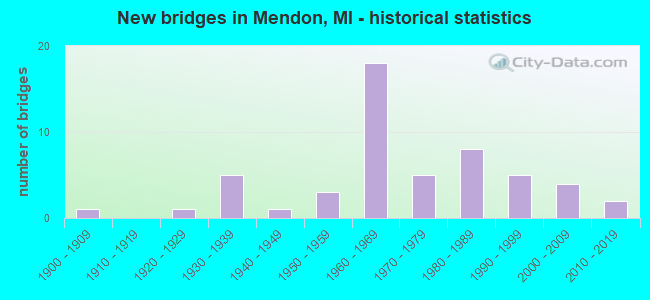
- New bridges - historical statistics
- 11900-1909
- 11920-1929
- 51930-1939
- 11940-1949
- 31950-1959
- 181960-1969
- 51970-1979
- 81980-1989
- 51990-1999
- 42000-2009
- 22010-2019

- Reconstructed bridges - Historical Statistics
- 11960-1969
- 01970-1979
- 01980-1989
- 11990-1999
- 22000-2009
- 22010-2019


- Bridge Condition - Deck
- 6.5%Very good
- 34.8%Good
- 28.3%Satisfactory
- 19.6%Fair
- 10.9%Poor

- Bridge Condition - Superstructure
- 8.7%Very good
- 32.6%Good
- 26.1%Satisfactory
- 26.1%Fair
- 2.2%Poor
- 4.3%Serious

- Bridge Condition - Substructure
- 21.7%Very good
- 32.6%Good
- 28.3%Satisfactory
- 10.9%Fair
- 6.5%Poor

- Bridge Condition - Channel
- 17.1%Very good
- 31.7%Good
- 34.1%Satisfactory
- 14.6%Fair
- 2.4%Poor

- Bridge Condition - Culverts
- 42.9%Good
- 28.6%Satisfactory
- 28.6%Fair
Find on map >> Show street view
Structure Number: 6925, Location: 3.2 MI ESE OF ISABELL COL (Lat: 43.756725, Lng: -84.550253), Route carried "on" structure: County highway 5680, Year Built: 1962, Status: Open, Structure Length: 9.20m (30.18ft), Average Daily Traffic: 1,381 (year 1996), Truck Traffic: 3%, Average Future Daily Traffic: 9,999 (year 1977), Design Load: HS 20, Features Intersected: US-10, Facility Carried by Structure: SHAFFER RD
Minimum Vertical Clearance: 30.48m (100.00ft), Kilometerpoint: 2.511, Lanes on structure: 2, Lanes under structure: 4, Owner: State Highway Agency, Approaching Roadway Width: 13.1m (43.0ft), Skew: 4 degrees, Material/Design: Steel, Design/Construction: Stringer/Multi-beam, Number Of Spans In Main Unit: 4, Length of Maximum Span: 31.2m (102.4ft), Curb-To-Curb Width: 8.9m (29.2ft), Out-to-Out Width: 9.9m (32.5ft)
Condition: Deck: Fair, Superstructure: Satisfactory, Substructure: Very good, Operating Rating: 50.2 metric tons, Method Used To Determine Operating Rating: Load Factor (LF) rating reported by rating factor (RF) method using MS18 loading, Inventory Rating: 30.1 metric tons, Method Used To Determine Inventory Rating: Load Factor (LF) rating reported by rating factor (RF) method using MS18 loading, Structural Evaluation: Equal to present minimum criteria, Deck Geometry: Somewhat better than minimum adequacy, Underclear: Somewhat better than minimum adequacy, Approach Roadway Alignment: Equal to present minimum criteria, Designated Inspection Frequency: Every 24 months, Inspection Date: June 2021, Deck Structure Type: Concrete Cast-file-Place, Wearing Surface/Protective System: Wearing Surface: Epoxy Overlay
Find on map >> Show street view
Structure Number: 10273, Location: IN MENDON (Lat: 42.006447, Lng: -85.456036), Route carried "on" structure: State highway 60, Year Built: 1929, Status: Open, Structure Length: 0.85m (2.79ft), Average Daily Traffic: 4,050 (year 2013), Truck Traffic: 7%, Average Future Daily Traffic: 4,500 (year 2035), Design Load: H 15, Features Intersected: LITTLE PORTAGE CREEK
Minimum Vertical Clearance: 30.48m (100.00ft), Kilometerpoint: 16.181, Lanes on structure: 2, Base Highway Network: Yes (Inventory Route: 375, Subroute: 37), Owner: State Highway Agency, Approaching Roadway Width: 9.5m (31.2ft), Material/Design: Concrete, Design/Construction: Tee Beam, Number Of Spans In Main Unit: 1, Length of Maximum Span: 8.5m (27.9ft), Curb or Sidewalk Widths: Left: 1.5m (4.9ft), Right: 1.5m (4.9ft), Curb-To-Curb Width: 9.5m (31.2ft), Out-to-Out Width: 21.5m (70.5ft)
Condition: Deck: Satisfactory, Superstructure: Satisfactory, Substructure: Satisfactory, Channel: Fair, Operating Rating: 54.5 metric tons, Method Used To Determine Operating Rating: Field evaluation and documented engineering judgment, Inventory Rating: 32.7 metric tons, Method Used To Determine Inventory Rating: Field evaluation and documented engineering judgment, Structural Evaluation: Equal to present minimum criteria, Deck Geometry: Meets minimum limits, Waterway Adequacy: Equal to present desirable criteria, Approach Roadway Alignment: Better than present minimum criteria, Designated Inspection Frequency: Every 24 months, Inspection Date: April 2021, Deck Structure Type: Concrete Cast-file-Place, Wearing Surface/Protective System: Wearing Surface: Bituminous
Find on map >> Show street view
Structure Number: 10274, Location: 1.2 MI E OF JCT M-66 (Lat: 42.010211, Lng: -85.387953), Route carried "on" structure: State highway 60, Year Built: 1931, Status: Open, Structure Length: 2.13m (6.99ft), Average Daily Traffic: 3,200 (year 2013), Truck Traffic: 14%, Average Future Daily Traffic: 5,076 (year 2018), Design Load: H 15, Features Intersected: NOTTAWA CREEK
Minimum Vertical Clearance: 30.48m (100.00ft), Kilometerpoint: 21.891, Lanes on structure: 2, Base Highway Network: Yes (Inventory Route: 375, Subroute: 37), Owner: State Highway Agency, Approaching Roadway Width: 9.4m (30.8ft), Skew: 2 degrees, Material/Design: Steel, Design/Construction: Stringer/Multi-beam, Number Of Spans In Main Unit: 2, Length of Maximum Span: 10.7m (35.1ft), Curb or Sidewalk Widths: Left: 0.6m (2.0ft), Right: 0.6m (2.0ft), Curb-To-Curb Width: 12.2m (40.0ft), Out-to-Out Width: 14.3m (46.9ft)
Condition: Deck: Fair, Superstructure: Fair, Substructure: Fair, Channel: Fair, Operating Rating: 57.3 metric tons, Method Used To Determine Operating Rating: Load Factor (LF) rating reported by rating factor (RF) method using MS18 loading, Inventory Rating: 34.3 metric tons, Method Used To Determine Inventory Rating: Load Factor (LF) rating reported by rating factor (RF) method using MS18 loading, Structural Evaluation: Somewhat better than minimum adequacy, Deck Geometry: Equal to present minimum criteria, Waterway Adequacy: Equal to present desirable criteria, Approach Roadway Alignment: Equal to present desirable criteria, Designated Inspection Frequency: Every 24 months, Inspection Date: July 2021, Deck Structure Type: Concrete Cast-file-Place, Wearing Surface/Protective System: Wearing Surface: Latex Concrete
Find on map >> Show street view
Structure Number: 10278, Location: 0.3 MI S OF M-60 (Lat: 42.007158, Lng: -85.411225), Route carried "on" structure: State highway 66, Year Built: 1965, Status: Open, Structure Length: 10.67m (35.01ft), Average Daily Traffic: 3,375 (year 2018), Truck Traffic: 10%, Average Future Daily Traffic: 3,750 (year 2038), Design Load: HS 20, Features Intersected: ST JOSEPH RIVER
Minimum Vertical Clearance: 30.48m (100.00ft), Kilometerpoint: 27.852, Lanes on structure: 2, Base Highway Network: Yes (Inventory Route: 23, Subroute: 4), Owner: State Highway Agency, Approaching Roadway Width: 9.1m (29.9ft), Skew: 3 degrees, Material/Design: Steel, Design/Construction: Stringer/Multi-beam, Number Of Spans In Main Unit: 5, Length of Maximum Span: 21.9m (71.9ft), Curb or Sidewalk Widths: Left: 0.2m (0.7ft), Right: 0.2m (0.7ft), Curb-To-Curb Width: 9.1m (29.9ft), Out-to-Out Width: 11.1m (36.4ft)
Condition: Deck: Satisfactory, Superstructure: Fair, Substructure: Good, Channel: Fair, Operating Rating: 68.0 metric tons, Method Used To Determine Operating Rating: Load Factor (LF) rating reported by rating factor (RF) method using MS18 loading, Inventory Rating: 40.5 metric tons, Method Used To Determine Inventory Rating: Load Factor (LF) rating reported by rating factor (RF) method using MS18 loading, Structural Evaluation: Somewhat better than minimum adequacy, Deck Geometry: Meets minimum limits, Waterway Adequacy: Equal to present desirable criteria, Approach Roadway Alignment: Equal to present minimum criteria, Designated Inspection Frequency: Every 24 months, Inspection Date: July 2021, Bridge Improvement Cost: $373,000, Deck Structure Type: Concrete Cast-file-Place, Wearing Surface/Protective System: Wearing Surface: Epoxy Overlay
Find on map >> Show street view
Structure Number: 10295, Location: SOUTH OF MENDON (Lat: 42.004897, Lng: -85.449542), Route carried "on" structure: County highway 7861, Year Built: 1968, Status: Open, Structure Length: 5.03m (16.50ft), Average Daily Traffic: 2,112 (year 2016), Truck Traffic: 5%, Average Future Daily Traffic: 2,334 (year 2036), Design Load: HS 20, Features Intersected: ST JOSEPH RIVER, Facility Carried by Structure: NOTTAWA ROAD
Minimum Vertical Clearance: 30.48m (100.00ft), Kilometerpoint: 15.210, Lanes on structure: 2, Owner: County Highway Agency, Approaching Roadway Width: 9.8m (32.2ft), Material/Design: Prestressed concrete, Design/Construction: Box Beam or Girders - Multiple, Number Of Spans In Main Unit: 3, Length of Maximum Span: 16.7m (54.8ft), Curb-To-Curb Width: 9.6m (31.5ft), Out-to-Out Width: 10.2m (33.5ft)
Condition: Deck: Good, Superstructure: Satisfactory, Substructure: Satisfactory, Channel: Satisfactory, Operating Rating: 59.3 metric tons, Method Used To Determine Operating Rating: Load Factor (LF) rating reported by rating factor (RF) method using MS18 loading, Inventory Rating: 35.6 metric tons, Method Used To Determine Inventory Rating: Load Factor (LF) rating reported by rating factor (RF) method using MS18 loading, Structural Evaluation: Equal to present minimum criteria, Deck Geometry: Meets minimum limits, Waterway Adequacy: Better than present minimum criteria, Approach Roadway Alignment: Equal to present minimum criteria, Designated Inspection Frequency: Every 24 months, Underwater Inspection Frequency: Every 60 months, Inspection Date: November 2021, Underwater Inspection Date: May 2018, Deck Structure Type: Concrete Precast Panels, Wearing Surface/Protective System: Wearing Surface: Bituminous, Membrane: Preformed Fabric
Find on map >> Show street view
Structure Number: 10299, Location: SOUTH OF PORTAGE LAKE (Lat: 42.038856, Lng: -85.515433), Route carried "on" structure: County highway 7892, Year Built: 1964, Status: Open, Structure Length: 2.07m (6.79ft), Average Daily Traffic: 1,003 (year 2003), Truck Traffic: 5%, Average Future Daily Traffic: 1,500 (year 2023), Design Load: HS 20, Features Intersected: PORTAGE RIVER, Facility Carried by Structure: MICHIGAN AVENUE
Minimum Vertical Clearance: 30.48m (100.00ft), Kilometerpoint: 10.305, Lanes on structure: 2, Owner: County Highway Agency, Approaching Roadway Width: 9.1m (29.9ft), Material/Design: Prestressed concrete, Design/Construction: Box Beam or Girders - Multiple, Number Of Spans In Main Unit: 2, Length of Maximum Span: 10.3m (33.8ft), Curb-To-Curb Width: 9.1m (29.9ft), Out-to-Out Width: 9.2m (30.2ft)
Condition: Deck: Good, Superstructure: Fair, Substructure: Good, Channel: Very good, Operating Rating: 54.6 metric tons, Method Used To Determine Operating Rating: Load Factor (LF), Inventory Rating: 32.7 metric tons, Method Used To Determine Inventory Rating: Load Factor (LF), Structural Evaluation: Somewhat better than minimum adequacy, Deck Geometry: Somewhat better than minimum adequacy, Waterway Adequacy: Better than present minimum criteria, Approach Roadway Alignment: Better than present minimum criteria, Designated Inspection Frequency: Every 24 months, Inspection Date: November 2021, Deck Structure Type: Other, Wearing Surface/Protective System: Wearing Surface: Bituminous
Find on map >> Show street view
Structure Number: 103, Location: 2.5 MI NE OF MENDON (Lat: 42.042878, Lng: -85.428325), Route carried "on" structure: County highway 7892, Year Built: 1968, Status: Posted for load, Structure Length: 0.97m (3.18ft), Average Daily Traffic: 541 (year 2003), Truck Traffic: 5%, Average Future Daily Traffic: 754 (year 2023), Design Load: HS 20, Features Intersected: LITTLE PORTAGE CREEK, Facility Carried by Structure: MICHIGAN AVENUE
Minimum Vertical Clearance: 30.48m (100.00ft), Kilometerpoint: 6.547, Lanes on structure: 2, Owner: County Highway Agency, Approaching Roadway Width: 7.9m (25.9ft), Skew: 1 degrees, Material/Design: Wood or Timber, Design/Construction: Stringer/Multi-beam, Number Of Spans In Main Unit: 1, Length of Maximum Span: 9.4m (30.8ft), Curb-To-Curb Width: 9.1m (29.9ft), Out-to-Out Width: 9.7m (31.8ft)
Condition: Deck: Satisfactory, Superstructure: Satisfactory, Substructure: Fair, Channel: Satisfactory, Operating Rating: 30.3 metric tons, Method Used To Determine Operating Rating: Allowable Stress (AS), Inventory Rating: 20.0 metric tons, Method Used To Determine Inventory Rating: Allowable Stress (AS), Structural Evaluation: Somewhat better than minimum adequacy, Deck Geometry: Equal to present minimum criteria, Waterway Adequacy: Equal to present minimum criteria, Approach Roadway Alignment: Equal to present desirable criteria, Bridge Posting: Required (Relationship of Operating Rating to Maximum Legal Load: > 39.9% below), Length Of Structure Improvement: 1.57m (5.15ft), Designated Inspection Frequency: Every 24 months, Inspection Date: November 2021, Bridge Improvement Cost: $135,000, Roadway Improvement Cost: $20,000, Total Project Cost: $155,000, Deck Structure Type: Wood or Timber, Wearing Surface/Protective System: Wearing Surface: Bituminous
Find on map >> Show street view
Structure Number: 10313, Location: 1.0 MI S OF PORTAGE LAKE (Lat: 42.031908, Lng: -85.517892), Route carried "on" structure: County highway 7849, Year Built: 2015, Status: Open, Structure Length: 2.59m (8.50ft), Average Daily Traffic: 3,557 (year 2015), Truck Traffic: 10%, Average Future Daily Traffic: 4,340 (year 2035), Design Load: Greater than HL93, Features Intersected: PORTAGE RIVER, Facility Carried by Structure: SILVER STREET
Minimum Vertical Clearance: 30.48m (100.00ft), Kilometerpoint: 6.122, Lanes on structure: 2, Base Highway Network: Yes (Inventory Route: 23, Subroute: 6), Owner: County Highway Agency, Approaching Roadway Width: 11.6m (38.1ft), Material/Design: Prestressed concrete, Design/Construction: Box Beam or Girders - Multiple, Number Of Spans In Main Unit: 1, Length of Maximum Span: 25.5m (83.7ft), Curb-To-Curb Width: 11.6m (38.1ft), Out-to-Out Width: 12.5m (41.0ft)
Condition: Deck: Very good, Superstructure: Very good, Substructure: Very good, Channel: Very good, Operating Rating: 57.0 metric tons, Method Used To Determine Operating Rating: Load and Resistance Factor Rating (LRFR) rating reported by rating factor(RF) method using HL-93 loadings, Inventory Rating: 43.7 metric tons, Method Used To Determine Inventory Rating: Load and Resistance Factor Rating (LRFR) rating reported by rating factor(RF) method using HL-93 loadings, Structural Evaluation: Equal to present desirable criteria, Deck Geometry: Somewhat better than minimum adequacy, Waterway Adequacy: Better than present minimum criteria, Approach Roadway Alignment: Better than present minimum criteria, Designated Inspection Frequency: Every 24 months, Inspection Date: November 2021, Deck Structure Type: Concrete Cast-file-Place, Wearing Surface/Protective System: Wearing Surface: Monolithic Concrete, Deck Protection: Epoxy Coated Reinforcing
Find on map >> Show street view
Structure Number: 10317, Location: 0.5 MI EAST OF WASEPI (Lat: 41.944903, Lng: -85.448822), Route carried "on" structure: County highway 7861, Year Built: 1987, Status: Open, Structure Length: 0.85m (2.79ft), Average Daily Traffic: 1,077 (year 2003), Truck Traffic: 5%, Average Future Daily Traffic: 1,553 (year 2023), Design Load: HS 20, Features Intersected: SPRING CREEK, Facility Carried by Structure: NOTTAWA ROAD
Minimum Vertical Clearance: 30.48m (100.00ft), Kilometerpoint: 8.496, Lanes on structure: 2, Owner: County Highway Agency, Approaching Roadway Width: 10.1m (33.1ft), Material/Design: Wood or Timber, Design/Construction: Slab, Number Of Spans In Main Unit: 1, Length of Maximum Span: 8.2m (26.9ft), Curb-To-Curb Width: 9.6m (31.5ft), Out-to-Out Width: 10.4m (34.1ft)
Condition: Deck: Good, Superstructure: Good, Substructure: Satisfactory, Channel: Satisfactory, Operating Rating: 56.1 metric tons, Method Used To Determine Operating Rating: Allowable Stress (AS) rating reported by rating factor (RF) method using MS18 loading, Inventory Rating: 38.6 metric tons, Method Used To Determine Inventory Rating: Allowable Stress (AS) rating reported by rating factor (RF) method using MS18 loading, Structural Evaluation: Equal to present minimum criteria, Deck Geometry: Somewhat better than minimum adequacy, Waterway Adequacy: Better than present minimum criteria, Approach Roadway Alignment: Better than present minimum criteria, Designated Inspection Frequency: Every 24 months, Inspection Date: November 2021, Deck Structure Type: Wood or Timber, Wearing Surface/Protective System: Wearing Surface: Bituminous
Find on map >> Show street view
Structure Number: 10318, Location: 1.5 MI NORTH OF MENDON (Lat: 42.024011, Lng: -85.449736), Route carried "on" structure: County highway , Year Built: 1966, Status: Posted for load, Structure Length: 1.52m (4.99ft), Average Daily Traffic: 1,821 (year 2003), Truck Traffic: 5%, Average Future Daily Traffic: 2,870 (year 2023), Design Load: HS 20, Features Intersected: WOOD LAKE DRAIN, Facility Carried by Structure: NOTTAWA ROAD
Minimum Vertical Clearance: 30.48m (100.00ft), Kilometerpoint: 17.282, Lanes on structure: 2, Owner: County Highway Agency, Approaching Roadway Width: 10.1m (33.1ft), Skew: 3 degrees, Material/Design: Wood or Timber, Design/Construction: Slab, Number Of Spans In Main Unit: 2, Length of Maximum Span: 7.6m (24.9ft), Curb-To-Curb Width: 9.1m (29.9ft), Out-to-Out Width: 9.5m (31.2ft)
Condition: Deck: Fair, Superstructure: Fair, Substructure: Poor, Channel: Satisfactory, Operating Rating: 36.6 metric tons, Method Used To Determine Operating Rating: Allowable Stress (AS) rating reported by rating factor (RF) method using MS18 loading, Inventory Rating: 25.6 metric tons, Method Used To Determine Inventory Rating: Allowable Stress (AS) rating reported by rating factor (RF) method using MS18 loading, Structural Evaluation: Meets minimum limits, Deck Geometry: Somewhat better than minimum adequacy, Waterway Adequacy: Equal to present minimum criteria, Approach Roadway Alignment: Equal to present minimum criteria, Bridge Posting: Required (Relationship of Operating Rating to Maximum Legal Load: 10.0 - 19.9% below), Designated Inspection Frequency: Every 12 months, Inspection Date: November 2021, Deck Structure Type: Wood or Timber, Wearing Surface/Protective System: Wearing Surface: Bituminous
Find on map >> Show street view
Structure Number: 10377, Location: 2.5 MI SW OF MENDON (Lat: 41.985072, Lng: -85.480800), Route carried "on" structure: County highway , Year Built: 1974, Status: Posted for load, Structure Length: 4.75m (15.58ft), Average Daily Traffic: 466 (year 2003), Truck Traffic: 5%, Average Future Daily Traffic: 721 (year 2023), Design Load: H 20, Features Intersected: ST JOSEPH RIVER, Facility Carried by Structure: PRAIRIE CORNER RD
Minimum Vertical Clearance: 30.48m (100.00ft), Kilometerpoint: 3.368, Lanes on structure: 2, Owner: County Highway Agency, Approaching Roadway Width: 9.1m (29.9ft), Material/Design: Wood or Timber, Design/Construction: Slab, Number Of Spans In Main Unit: 6, Length of Maximum Span: 7.9m (25.9ft), Curb-To-Curb Width: 9.1m (29.9ft), Out-to-Out Width: 9.6m (31.5ft)
Condition: Deck: Poor, Superstructure: Serious, Substructure: Poor, Channel: Fair, Operating Rating: 20.1 metric tons, Method Used To Determine Operating Rating: Allowable Stress (AS) rating reported by rating factor (RF) method using MS18 loading, Inventory Rating: 13.6 metric tons, Method Used To Determine Inventory Rating: Allowable Stress (AS) rating reported by rating factor (RF) method using MS18 loading, Structural Evaluation: High priority of corrective action, Deck Geometry: Equal to present minimum criteria, Waterway Adequacy: Equal to present minimum criteria, Approach Roadway Alignment: Meets minimum limits, Bridge Posting: Required (Relationship of Operating Rating to Maximum Legal Load: > 39.9% below), Designated Inspection Frequency: Every 12 months, Underwater Inspection Frequency: Every 60 months, Inspection Date: November 2021, Underwater Inspection Date: May 2018, Deck Structure Type: Wood or Timber, Wearing Surface/Protective System: Wearing Surface: Bituminous
Find on map >> Show street view
Structure Number: 1038, Location: 4 MI NW OF MENDON (Lat: 42.056400, Lng: -85.494017), Route carried "on" structure: County highway , Year Built: 1998, Status: Open, Structure Length: 1.10m (3.61ft), Average Daily Traffic: 81 (year 2003), Truck Traffic: 5%, Average Future Daily Traffic: 131 (year 2023), Features Intersected: CREEK, Facility Carried by Structure: HALLUMM
Minimum Vertical Clearance: 30.48m (100.00ft), Kilometerpoint: 1.915, Lanes on structure: 2, Owner: County Highway Agency, Approaching Roadway Width: 7.9m (25.9ft), Skew: 2 degrees, Material/Design: Wood or Timber, Design/Construction: Slab, Number Of Spans In Main Unit: 2, Length of Maximum Span: 5.5m (18.0ft), Curb-To-Curb Width: 9.1m (29.9ft), Out-to-Out Width: 9.7m (31.8ft)
Condition: Deck: Good, Superstructure: Very good, Substructure: Very good, Channel: Satisfactory, Operating Rating: 43.5 metric tons, Method Used To Determine Operating Rating: Allowable Stress (AS), Inventory Rating: 31.7 metric tons, Method Used To Determine Inventory Rating: Allowable Stress (AS), Structural Evaluation: Better than present minimum criteria, Waterway Adequacy: Somewhat better than minimum adequacy, Approach Roadway Alignment: Better than present minimum criteria, Designated Inspection Frequency: Every 24 months, Inspection Date: November 2021, Deck Structure Type: Wood or Timber, Wearing Surface/Protective System: Wearing Surface: Bituminous
Find on map >> Show street view
Structure Number: 10381, Location: 4 MI NE OF MENDON (Lat: 42.058886, Lng: -85.411033), Route carried "on" structure: County highway , Year Built: 1968, Status: Posted for load, Structure Length: 0.97m (3.18ft), Average Daily Traffic: 133 (year 2003), Truck Traffic: 5%, Average Future Daily Traffic: 177 (year 2023), Design Load: H 20, Features Intersected: PORTAGE CREEK, Facility Carried by Structure: MCCLISH ROAD
Minimum Vertical Clearance: 30.48m (100.00ft), Kilometerpoint: 1.764, Lanes on structure: 2, Owner: County Highway Agency, Approaching Roadway Width: 9.1m (29.9ft), Skew: 4 degrees, Material/Design: Wood or Timber, Design/Construction: Stringer/Multi-beam, Number Of Spans In Main Unit: 1, Length of Maximum Span: 9.1m (29.9ft), Curb-To-Curb Width: 9.1m (29.9ft), Out-to-Out Width: 9.6m (31.5ft)
Condition: Deck: Fair, Superstructure: Satisfactory, Substructure: Fair, Channel: Satisfactory, Operating Rating: 30.9 metric tons, Method Used To Determine Operating Rating: Allowable Stress (AS), Inventory Rating: 20.9 metric tons, Method Used To Determine Inventory Rating: Allowable Stress (AS), Structural Evaluation: Somewhat better than minimum adequacy, Deck Geometry: Equal to present minimum criteria, Waterway Adequacy: Somewhat better than minimum adequacy, Approach Roadway Alignment: Somewhat better than minimum adequacy, Bridge Posting: Required (Relationship of Operating Rating to Maximum Legal Load: 30.0 - 39.9% below), Length Of Structure Improvement: 1.57m (5.15ft), Designated Inspection Frequency: Every 24 months, Inspection Date: November 2021, Bridge Improvement Cost: $135,000, Roadway Improvement Cost: $15,000, Total Project Cost: $150,000, Deck Structure Type: Wood or Timber, Wearing Surface/Protective System: Wearing Surface: Bituminous
Find on map >> Show street view
Structure Number: 10384, Location: 3.5 MI E OF MENDON (Lat: 42.013094, Lng: -85.381322), Route carried "on" structure: County highway , Year Built: 1984, Status: Open, Structure Length: 2.68m (8.79ft), Average Daily Traffic: 233 (year 2003), Truck Traffic: 5%, Average Future Daily Traffic: 279 (year 2023), Design Load: H 20, Features Intersected: NOTTAWA CREEK, Facility Carried by Structure: OLNEY ROAD
Minimum Vertical Clearance: 30.48m (100.00ft), Kilometerpoint: 1.160, Lanes on structure: 2, Owner: County Highway Agency, Approaching Roadway Width: 9.1m (29.9ft), Material/Design: Wood or Timber, Design/Construction: Slab, Number Of Spans In Main Unit: 4, Length of Maximum Span: 6.7m (22.0ft), Curb-To-Curb Width: 9.1m (29.9ft), Out-to-Out Width: 9.5m (31.2ft)
Condition: Deck: Good, Superstructure: Good, Substructure: Good, Channel: Good, Operating Rating: 51.0 metric tons, Method Used To Determine Operating Rating: Allowable Stress (AS), Inventory Rating: 36.0 metric tons, Method Used To Determine Inventory Rating: Allowable Stress (AS), Structural Evaluation: Better than present minimum criteria, Deck Geometry: Equal to present minimum criteria, Waterway Adequacy: Better than present minimum criteria, Approach Roadway Alignment: Equal to present minimum criteria, Designated Inspection Frequency: Every 24 months, Inspection Date: November 2021, Deck Structure Type: Wood or Timber, Wearing Surface/Protective System: Wearing Surface: Bituminous