Bridge Statistics for Miami, Florida (FL)
Condition, Traffic, Stress, Structural Evaluation, Project Costs
- National Bridge Inventory (NBI) Statistics
- 872Number of bridges
- 19,954ft / 6,082mTotal length
- $17,291,000Total costs
- 27,280,354Total average daily traffic
- 1,538,422Total average daily truck traffic
- National Bridge Inventory (NBI) Registered Bridges for Miami
- No street view available for this location
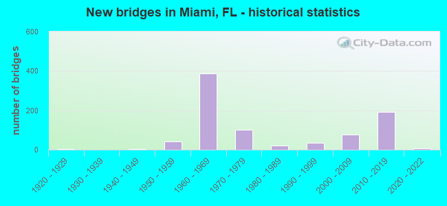
- New bridges - historical statistics
- 11910-1919
- 51920-1929
- 41940-1949
- 421950-1959
- 3861960-1969
- 1011970-1979
- 211980-1989
- 351990-1999
- 762000-2009
- 1932010-2019
- 82020-2022
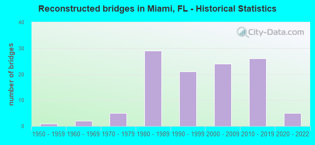
- Reconstructed bridges - Historical Statistics
- 11950-1959
- 21960-1969
- 51970-1979
- 291980-1989
- 211990-1999
- 242000-2009
- 262010-2019
- 52020-2022
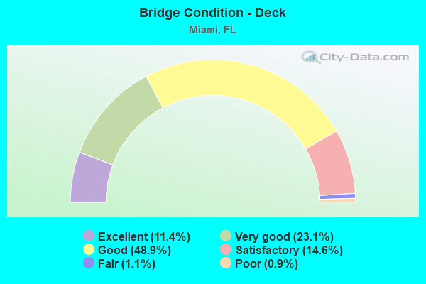
- Bridge Condition - Deck
- 11.4%Excellent
- 23.1%Very good
- 48.9%Good
- 14.6%Satisfactory
- 1.1%Fair
- 0.9%Poor
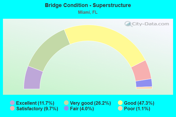
- Bridge Condition - Superstructure
- 11.7%Excellent
- 26.2%Very good
- 47.3%Good
- 9.7%Satisfactory
- 4.0%Fair
- 1.1%Poor
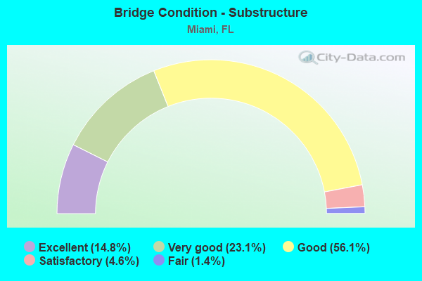
- Bridge Condition - Substructure
- 14.8%Excellent
- 23.1%Very good
- 56.1%Good
- 4.6%Satisfactory
- 1.4%Fair
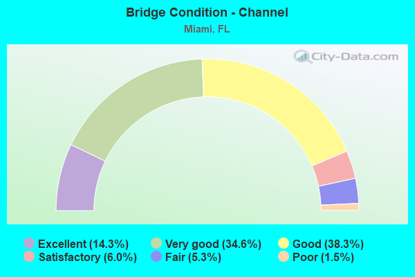
- Bridge Condition - Channel
- 14.3%Excellent
- 34.6%Very good
- 38.3%Good
- 6.0%Satisfactory
- 5.3%Fair
- 1.5%Poor
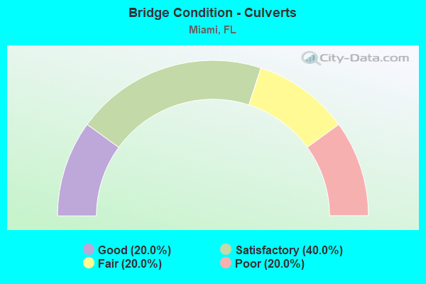
- Bridge Condition - Culverts
- 20.0%Good
- 40.0%Satisfactory
- 20.0%Fair
- 20.0%Poor
Find on map >> Show street view
Structure Number: 870427, Location: 1MI N OF I-195 (Lat: 25.824111, Lng: -80.206372), Route carried "under" structure: City street , Year Built: 1959, Structure Length: 0. m, Average Daily Traffic: 2,400 (year 2021), Truck Traffic: 1%, Features Intersected: NW 53 Street, Facility Carried by Structure: I-95 NB (870306)
Minimum Vertical Clearance: 4.60m (15.09ft), Kilometerpoint: 0.000, Lanes on structure: 7, Lanes under structure: 2, Material/Design: Prestressed concrete, Design/Construction: Stringer/Multi-beam, Length of Maximum Span: 23.2m (76.1ft)
Find on map >> Show street view
Structure Number: 870428, Location: AT NW 54TH ST (Lat: 25.825000, Lng: -80.206389), Route carried "under" structure: State highway 944, Year Built: 1959, Structure Length: 0. m, Average Daily Traffic: 12,400 (year 2021), Truck Traffic: 4%, Features Intersected: SR-944 (NW 54 ST), Facility Carried by Structure: I-95 NB (870307)
Minimum Vertical Clearance: 4.66m (15.29ft), Kilometerpoint: 7.390, Lanes on structure: 7, Lanes under structure: 4, Material/Design: Prestressed concrete, Design/Construction: Stringer/Multi-beam, Length of Maximum Span: 23.2m (76.1ft)
Find on map >> Show street view
Structure Number: 870429, Location: 1MI S OF SR-934 (Lat: 25.832222, Lng: -80.205833), Route carried "under" structure: City street , Year Built: 1961, Structure Length: 0. m, Average Daily Traffic: 8,600 (year 2020), Truck Traffic: 4%, Features Intersected: NW 62 ST, Facility Carried by Structure: I-95 NB (870308)
Minimum Vertical Clearance: 4.72m (15.49ft), Kilometerpoint: 0.000, Lanes on structure: 6, Lanes under structure: 7, Material/Design: Prestressed concrete, Design/Construction: Stringer/Multi-beam, Length of Maximum Span: 23.2m (76.1ft)
Find on map >> Show street view
Structure Number: 87043, Location: 0.2 MI S of SR-934 NW 79 (Lat: 25.841472, Lng: -80.205964), Route carried "under" structure: City street , Year Built: 1959, Structure Length: 0. m, Average Daily Traffic: 480 (year 2021), Truck Traffic: 1%, Features Intersected: NW 71-75 ST NW 5th PL RR, Facility Carried by Structure: I-95 NB (870309)
Minimum Vertical Clearance: 7.07m (23.20ft), Kilometerpoint: 0.000, Lanes on structure: 7, Lanes under structure: 2, Material/Design: Prestressed concrete, Design/Construction: Stringer/Multi-beam, Length of Maximum Span: 23.2m (76.1ft)
Find on map >> Show street view
Structure Number: 87043, Location: 0.2 MI S of SR-934 NW 79 (Lat: 25.841472, Lng: -80.205964), Route carried "under" structure: City street , Year Built: 1959, Structure Length: 0. m, Average Daily Traffic: 5,600 (year 2021), Truck Traffic: 2%, Features Intersected: NW 71-75 ST NW 5th PL RR, Facility Carried by Structure: I-95 NB (870309)
Minimum Vertical Clearance: 5.39m (17.68ft), Kilometerpoint: 0.000, Lanes on structure: 7, Lanes under structure: 2, Material/Design: Prestressed concrete, Design/Construction: Stringer/Multi-beam, Length of Maximum Span: 23.2m (76.1ft)
Find on map >> Show street view
Structure Number: 87043, Location: 0.2 MI S of SR-934 NW 79 (Lat: 25.841472, Lng: -80.205964), Route carried "under" structure: City street , Year Built: 1959, Structure Length: 0. m, Average Daily Traffic: 100 (year 2021), Truck Traffic: 1%, Features Intersected: NW 71-75 ST NW 5th PL RR, Facility Carried by Structure: I-95 NB (870309)
Minimum Vertical Clearance: 7.65m (25.10ft), Kilometerpoint: 0.000, Lanes on structure: 7, Lanes under structure: 2, Material/Design: Prestressed concrete, Design/Construction: Stringer/Multi-beam, Length of Maximum Span: 23.2m (76.1ft)
Find on map >> Show street view
Structure Number: 87043, Location: 0.2 MI S of SR-934 NW 79 (Lat: 25.841472, Lng: -80.205964), Route carried "under" structure: City street , Year Built: 1959, Structure Length: 0. m, Average Daily Traffic: 1,400 (year 2020), Truck Traffic: 4%, Features Intersected: NW 71-75 ST NW 5th PL RR, Facility Carried by Structure: I-95 NB (870309)
Minimum Vertical Clearance: 5.18m (16.99ft), Kilometerpoint: 2.882, Lanes on structure: 7, Lanes under structure: 2, Material/Design: Prestressed concrete, Design/Construction: Stringer/Multi-beam, Length of Maximum Span: 23.2m (76.1ft)
Find on map >> Show street view
Structure Number: 870431, Location: 1MI S OF NW 95TH ST (Lat: 25.846944, Lng: -80.207500), Route carried "under" structure: State highway 934, Year Built: 1961, Structure Length: 0. m, Average Daily Traffic: 25,700 (year 2020), Truck Traffic: 8%, Features Intersected: NW 79TH ST (SR-934), Facility Carried by Structure: I-95 NB (870315)
Minimum Vertical Clearance: 4.39m (14.40ft), Kilometerpoint: 62.064, Lanes on structure: 6, Lanes under structure: 5, Material/Design: Prestressed concrete, Design/Construction: Stringer/Multi-beam, Length of Maximum Span: 21.9m (71.9ft)
Find on map >> Show street view
Structure Number: 870434, Location: 0.5MI S OF SR-932(103 ST) (Lat: 25.861861, Lng: -80.208306), Route carried "under" structure: City street , Year Built: 1961, Structure Length: 0. m, Average Daily Traffic: 27,500 (year 2022), Truck Traffic: 5%, Features Intersected: NW 95 ST, Facility Carried by Structure: I-95
Minimum Vertical Clearance: 4.66m (15.29ft), Kilometerpoint: 1.770, Lanes on structure: 12, Lanes under structure: 6, Material/Design: Prestressed concrete, Design/Construction: Stringer/Multi-beam, Length of Maximum Span: 15.8m (51.8ft)
Find on map >> Show street view
Structure Number: 870436, Location: I95 AT NW 111TH ST (Lat: 25.876528, Lng: -80.208944), Route carried "under" structure: City street , Year Built: 1961, Structure Length: 0. m, Average Daily Traffic: 3,900 (year 2020), Truck Traffic: 4%, Features Intersected: NW 111TH ST, Facility Carried by Structure: I-95
Minimum Vertical Clearance: 4.54m (14.90ft), Kilometerpoint: 2.551, Lanes on structure: 12, Lanes under structure: 2, Material/Design: Prestressed concrete, Design/Construction: Stringer/Multi-beam, Length of Maximum Span: 20.7m (67.9ft)
Find on map >> Show street view
Structure Number: 87044, Location: I-95/SR112/I-195 INTRCHG (Lat: 25.812572, Lng: -80.205886), Route carried "under" structure: State highway 112, Year Built: 1961, Structure Length: 0. m, Average Daily Traffic: 78,500 (year 2020), Truck Traffic: 5%, Features Intersected: I-195 (SR-112), Facility Carried by Structure: I-95 NB
Minimum Vertical Clearance: 4.75m (15.58ft), Kilometerpoint: 0.781, Lanes on structure: 5, Lanes under structure: 4, Material/Design: Prestressed concrete, Design/Construction: Stringer/Multi-beam, Length of Maximum Span: 13.7m (44.9ft)
Find on map >> Show street view
Structure Number: 870448, Location: AT SW 25TH RD (Lat: 25.752783, Lng: -80.205289), Route carried "under" structure: City street , Year Built: 1965, Structure Length: 0. m, Average Daily Traffic: 16,500 (year 2020), Truck Traffic: 3%, Features Intersected: SW 25TH & 26TH ROADS, Facility Carried by Structure: I-95
Minimum Vertical Clearance: 4.51m (14.80ft), Kilometerpoint: 0.066, Lanes on structure: 4, Lanes under structure: 4, Material/Design: Prestressed concrete, Design/Construction: Stringer/Multi-beam, Length of Maximum Span: 21.9m (71.9ft)
Find on map >> Show street view
Structure Number: 870448, Location: AT SW 25TH RD (Lat: 25.752783, Lng: -80.205289), Route carried "under" structure: City street , Year Built: 1965, Structure Length: 0. m, Average Daily Traffic: 14,400 (year 2014), Truck Traffic: 8%, Features Intersected: SW 25TH & 26TH ROADS, Facility Carried by Structure: I-95
Minimum Vertical Clearance: 4.60m (15.09ft), Kilometerpoint: 0.000, Lanes on structure: 4, Lanes under structure: 4, Material/Design: Prestressed concrete, Design/Construction: Stringer/Multi-beam, Length of Maximum Span: 21.9m (71.9ft)
Find on map >> Show street view
Structure Number: 87045, Location: 1.9 MI S OF NW 62ND ST (Lat: 25.803681, Lng: -80.205739), Route carried "under" structure: City street , Year Built: 1965, Structure Length: 0. m, Average Daily Traffic: 10,100 (year 2020), Truck Traffic: 5%, Features Intersected: NW 29TH STREET, Facility Carried by Structure: I-95
Minimum Vertical Clearance: 4.51m (14.80ft), Kilometerpoint: 1.770, Lanes on structure: 13, Lanes under structure: 4, Material/Design: Prestressed concrete, Design/Construction: Stringer/Multi-beam, Length of Maximum Span: 24.7m (81.0ft)
Find on map >> Show street view
Structure Number: 870451, Location: 1MI S of SR-90 (Lat: 25.756969, Lng: -80.199947), Route carried "under" structure: City street , Year Built: 1969, Structure Length: 0. m, Average Daily Traffic: 3,261 (year 2021), Truck Traffic: 1%, Features Intersected: SW 1ST AVE, Facility Carried by Structure: I-95 NB (870354)
Minimum Vertical Clearance: 7.59m (24.90ft), Kilometerpoint: 0.000, Lanes on structure: 3, Lanes under structure: 2, Material/Design: Steel continuous, Design/Construction: Stringer/Multi-beam, Length of Maximum Span: 41.5m (136.2ft)
Find on map >> Show street view
Structure Number: 870452, Location: AT SR-972 (SW 3RD AVE.) (Lat: 25.761544, Lng: -80.199611), Route carried "under" structure: State highway 972, Year Built: 1965, Structure Length: 0. m, Average Daily Traffic: 19,500 (year 2020), Truck Traffic: 2%, Features Intersected: SW 3RD AVE & BROADWAY, Facility Carried by Structure: I-95 NB (870355)
Minimum Vertical Clearance: 4.60m (15.09ft), Kilometerpoint: 6.706, Lanes on structure: 3, Lanes under structure: 5, Material/Design: Prestressed concrete, Design/Construction: Stringer/Multi-beam, Length of Maximum Span: 24.7m (81.0ft)
Find on map >> Show street view
Structure Number: 870452, Location: AT SR-972 (SW 3RD AVE.) (Lat: 25.761544, Lng: -80.199611), Route carried "under" structure: City street , Year Built: 1965, Structure Length: 0. m, Average Daily Traffic: 2,880 (year 2020), Truck Traffic: 4%, Features Intersected: SW 3RD AVE & BROADWAY, Facility Carried by Structure: I-95 NB (870355)
Minimum Vertical Clearance: 5.09m (16.70ft), Kilometerpoint: 0.000, Lanes on structure: 3, Lanes under structure: 2, Material/Design: Prestressed concrete, Design/Construction: Stringer/Multi-beam, Length of Maximum Span: 24.7m (81.0ft)
Find on map >> Show street view
Structure Number: 870453, Location: DOWNTOWN INTERCHG (Lat: 25.770417, Lng: -80.199167), Route carried "under" structure: City street , Year Built: 1967, Structure Length: 0. m, Average Daily Traffic: 8,900 (year 2021), Truck Traffic: 4%, Features Intersected: SW8TH ST-NW8TH ST/MIAMI, Facility Carried by Structure: I-95 NB (870356)
Minimum Vertical Clearance: 5.03m (16.50ft), Kilometerpoint: 0.032, Lanes on structure: 4, Lanes under structure: 4, Material/Design: Steel continuous, Design/Construction: Stringer/Multi-beam, Length of Maximum Span: 61.0m (200.1ft)
Find on map >> Show street view
Structure Number: 870453, Location: DOWNTOWN INTERCHG (Lat: 25.770417, Lng: -80.199167), Route carried "under" structure: City street , Year Built: 1967, Structure Length: 0. m, Average Daily Traffic: 8,000 (year 2021), Truck Traffic: 1%, Features Intersected: SW8TH ST-NW8TH ST/MIAMI, Facility Carried by Structure: I-95 NB (870356)
Minimum Vertical Clearance: 4.29m (14.07ft), Kilometerpoint: 0.000, Lanes on structure: 4, Lanes under structure: 2, Material/Design: Steel continuous, Design/Construction: Stringer/Multi-beam, Length of Maximum Span: 61.0m (200.1ft)
Find on map >> Show street view
Structure Number: 870453, Location: DOWNTOWN INTERCHG (Lat: 25.770417, Lng: -80.199167), Route carried "under" structure: City street , Year Built: 1967, Structure Length: 0. m, Average Daily Traffic: 6,900 (year 2021), Truck Traffic: 7%, Features Intersected: SW8TH ST-NW8TH ST/MIAMI, Facility Carried by Structure: I-95 NB (870356)
Minimum Vertical Clearance: 4.60m (15.09ft), Kilometerpoint: 0.642, Lanes on structure: 4, Lanes under structure: 4, Material/Design: Steel continuous, Design/Construction: Stringer/Multi-beam, Length of Maximum Span: 61.0m (200.1ft)
Find on map >> Show street view
Structure Number: 870453, Location: DOWNTOWN INTERCHG (Lat: 25.770417, Lng: -80.199167), Route carried "under" structure: City street , Year Built: 1967, Structure Length: 0. m, Average Daily Traffic: 3,600 (year 2021), Truck Traffic: 4%, Features Intersected: SW8TH ST-NW8TH ST/MIAMI, Facility Carried by Structure: I-95 NB (870356)
Minimum Vertical Clearance: 4.88m (16.01ft), Kilometerpoint: 1.072, Lanes on structure: 4, Lanes under structure: 3, Material/Design: Steel continuous, Design/Construction: Stringer/Multi-beam, Length of Maximum Span: 61.0m (200.1ft)
Find on map >> Show street view
Structure Number: 870453, Location: DOWNTOWN INTERCHG (Lat: 25.770417, Lng: -80.199167), Route carried "under" structure: City street , Year Built: 1967, Structure Length: 0. m, Average Daily Traffic: 1,822 (year 2021), Truck Traffic: 1%, Features Intersected: SW8TH ST-NW8TH ST/MIAMI, Facility Carried by Structure: I-95 NB (870356)
Minimum Vertical Clearance: 5.39m (17.68ft), Kilometerpoint: 0.000, Lanes on structure: 4, Lanes under structure: 2, Material/Design: Steel continuous, Design/Construction: Stringer/Multi-beam, Length of Maximum Span: 61.0m (200.1ft)
Find on map >> Show street view
Structure Number: 870453, Location: DOWNTOWN INTERCHG (Lat: 25.770417, Lng: -80.199167), Route carried "under" structure: City street , Year Built: 1967, Structure Length: 0. m, Average Daily Traffic: 11,000 (year 2021), Truck Traffic: 3%, Features Intersected: SW8TH ST-NW8TH ST/MIAMI, Facility Carried by Structure: I-95 NB (870356)
Minimum Vertical Clearance: 4.42m (14.50ft), Kilometerpoint: 0.000, Lanes on structure: 4, Lanes under structure: 4, Material/Design: Steel continuous, Design/Construction: Stringer/Multi-beam, Length of Maximum Span: 61.0m (200.1ft)
Find on map >> Show street view
Structure Number: 870453, Location: DOWNTOWN INTERCHG (Lat: 25.770417, Lng: -80.199167), Route carried "under" structure: Ramp Interstate 95, Year Built: 1967, Structure Length: 0. m, Average Daily Traffic: 15,000 (year 2021), Truck Traffic: 6%, Features Intersected: SW8TH ST-NW8TH ST/MIAMI
Minimum Vertical Clearance: 4.63m (15.19ft), Kilometerpoint: 0.122, Lanes on structure: 4, Lanes under structure: 1, Material/Design: Steel continuous, Design/Construction: Stringer/Multi-beam, Length of Maximum Span: 61.0m (200.1ft)
Find on map >> Show street view
Structure Number: 870453, Location: DOWNTOWN INTERCHG (Lat: 25.770417, Lng: -80.199167), Route carried "under" structure: US 41, Year Built: 1967, Structure Length: 0. m, Average Daily Traffic: 23,500 (year 2021), Truck Traffic: 4%, Features Intersected: SW8TH ST-NW8TH ST/MIAMI, Facility Carried by Structure: I-95 NB (870356)
Minimum Vertical Clearance: 6.98m (22.90ft), Kilometerpoint: 28.210, Lanes on structure: 4, Lanes under structure: 4, Material/Design: Steel continuous, Design/Construction: Stringer/Multi-beam, Length of Maximum Span: 61.0m (200.1ft)
Find on map >> Show street view
Structure Number: 870453, Location: DOWNTOWN INTERCHG (Lat: 25.770417, Lng: -80.199167), Route carried "under" structure: State highway 90, Year Built: 1967, Structure Length: 0. m, Average Daily Traffic: 10,500 (year 2021), Truck Traffic: 6%, Features Intersected: SW8TH ST-NW8TH ST/MIAMI, Facility Carried by Structure: I-95 NB (870356)
Minimum Vertical Clearance: 8.05m (26.41ft), Kilometerpoint: 0.972, Lanes on structure: 4, Lanes under structure: 3, Material/Design: Steel continuous, Design/Construction: Stringer/Multi-beam, Length of Maximum Span: 61.0m (200.1ft)
Find on map >> Show street view
Structure Number: 870453, Location: DOWNTOWN INTERCHG (Lat: 25.770417, Lng: -80.199167), Route carried "under" structure: City street , Year Built: 1967, Structure Length: 0. m, Average Daily Traffic: 4,200 (year 2021), Truck Traffic: 2%, Features Intersected: SW8TH ST-NW8TH ST/MIAMI, Facility Carried by Structure: I-95 NB (870356)
Minimum Vertical Clearance: 12.62m (41.40ft), Kilometerpoint: 0.000, Lanes on structure: 4, Lanes under structure: 2, Material/Design: Steel continuous, Design/Construction: Stringer/Multi-beam, Length of Maximum Span: 61.0m (200.1ft)
Find on map >> Show street view
Structure Number: 870453, Location: DOWNTOWN INTERCHG (Lat: 25.770417, Lng: -80.199167), Route carried "under" structure: City street , Year Built: 1967, Structure Length: 0. m, Average Daily Traffic: 100 (year 2021), Truck Traffic: 5%, Features Intersected: SW8TH ST-NW8TH ST/MIAMI, Facility Carried by Structure: I-95 NB (870356)
Minimum Vertical Clearance: 17.68m (58.01ft), Kilometerpoint: 0.000, Lanes on structure: 4, Lanes under structure: 2, Material/Design: Steel continuous, Design/Construction: Stringer/Multi-beam, Length of Maximum Span: 61.0m (200.1ft)
Find on map >> Show street view
Structure Number: 870453, Location: DOWNTOWN INTERCHG (Lat: 25.770417, Lng: -80.199167), Route carried "under" structure: Ramp Interstate , Year Built: 1967, Structure Length: 0. m, Average Daily Traffic: 13,000 (year 2021), Truck Traffic: 7%, Features Intersected: SW8TH ST-NW8TH ST/MIAMI, Facility Carried by Structure: I-95 NB (870356)
Minimum Vertical Clearance: 4.57m (14.99ft), Kilometerpoint: 0.497, Lanes on structure: 4, Lanes under structure: 2, Material/Design: Steel continuous, Design/Construction: Stringer/Multi-beam, Length of Maximum Span: 61.0m (200.1ft)
Find on map >> Show street view
Structure Number: 870453, Location: DOWNTOWN INTERCHG (Lat: 25.770417, Lng: -80.199167), Route carried "under" structure: City street , Year Built: 1967, Structure Length: 0. m, Average Daily Traffic: 6,351 (year 2021), Truck Traffic: 2%, Features Intersected: SW8TH ST-NW8TH ST/MIAMI, Facility Carried by Structure: I-95 NB (870356)
Minimum Vertical Clearance: 17.68m (58.01ft), Kilometerpoint: 0.000, Lanes on structure: 4, Lanes under structure: 2, Material/Design: Steel continuous, Design/Construction: Stringer/Multi-beam, Length of Maximum Span: 61.0m (200.1ft)
Find on map >> Show street view
Structure Number: 870453, Location: DOWNTOWN INTERCHG (Lat: 25.770417, Lng: -80.199167), Route carried "under" structure: City street , Year Built: 1967, Structure Length: 0. m, Average Daily Traffic: 1,984 (year 2021), Truck Traffic: 5%, Features Intersected: SW8TH ST-NW8TH ST/MIAMI, Facility Carried by Structure: I-95 NB (870356)
Minimum Vertical Clearance: 14.33m (47.01ft), Kilometerpoint: 0.000, Lanes on structure: 4, Lanes under structure: 3, Material/Design: Steel continuous, Design/Construction: Stringer/Multi-beam, Length of Maximum Span: 61.0m (200.1ft)
Find on map >> Show street view
Structure Number: 870453, Location: DOWNTOWN INTERCHG (Lat: 25.770417, Lng: -80.199167), Route carried "under" structure: City street , Year Built: 1967, Structure Length: 0. m, Average Daily Traffic: 3,250 (year 2021), Truck Traffic: 4%, Features Intersected: SW8TH ST-NW8TH ST/MIAMI, Facility Carried by Structure: I-95 NB (870356)
Minimum Vertical Clearance: 5.30m (17.39ft), Kilometerpoint: 0.035, Lanes on structure: 4, Lanes under structure: 3, Material/Design: Steel continuous, Design/Construction: Stringer/Multi-beam, Length of Maximum Span: 61.0m (200.1ft)
Find on map >> Show street view
Structure Number: 870453, Location: DOWNTOWN INTERCHG (Lat: 25.770417, Lng: -80.199167), Route carried "under" structure: City street , Year Built: 1967, Structure Length: 0. m, Average Daily Traffic: 5,800 (year 2021), Truck Traffic: 16%, Features Intersected: SW8TH ST-NW8TH ST/MIAMI, Facility Carried by Structure: I-95 NB (870356)
Minimum Vertical Clearance: 7.80m (25.59ft), Kilometerpoint: 1.180, Lanes on structure: 4, Lanes under structure: 3, Material/Design: Steel continuous, Design/Construction: Stringer/Multi-beam, Length of Maximum Span: 61.0m (200.1ft)
Find on map >> Show street view
Structure Number: 870453, Location: DOWNTOWN INTERCHG (Lat: 25.770417, Lng: -80.199167), Route carried "under" structure: Ramp Interstate 95, Year Built: 1967, Structure Length: 0. m, Average Daily Traffic: 25,000 (year 2021), Truck Traffic: 4%, Features Intersected: SW8TH ST-NW8TH ST/MIAMI
Minimum Vertical Clearance: 4.63m (15.19ft), Kilometerpoint: 0.135, Lanes on structure: 4, Lanes under structure: 1, Material/Design: Steel continuous, Design/Construction: Stringer/Multi-beam, Length of Maximum Span: 61.0m (200.1ft)
Find on map >> Show street view
Structure Number: 870453, Location: DOWNTOWN INTERCHG (Lat: 25.770417, Lng: -80.199167), Route carried "under" structure: State highway 968, Year Built: 1967, Structure Length: 0. m, Average Daily Traffic: 8,700 (year 2021), Truck Traffic: 9%, Features Intersected: SW8TH ST-NW8TH ST/MIAMI, Facility Carried by Structure: I-95 NB (870356)
Minimum Vertical Clearance: 9.45m (31.00ft), Kilometerpoint: 3.661, Lanes on structure: 4, Lanes under structure: 2, Material/Design: Steel continuous, Design/Construction: Stringer/Multi-beam, Length of Maximum Span: 61.0m (200.1ft)
Find on map >> Show street view
Structure Number: 870453, Location: DOWNTOWN INTERCHG (Lat: 25.770417, Lng: -80.199167), Route carried "under" structure: City street , Year Built: 1967, Structure Length: 0. m, Average Daily Traffic: 13,000 (year 2021), Truck Traffic: 16%, Features Intersected: SW8TH ST-NW8TH ST/MIAMI, Facility Carried by Structure: I-95 NB (870356)
Minimum Vertical Clearance: 7.96m (26.12ft), Kilometerpoint: 13.826, Lanes on structure: 4, Lanes under structure: 1, Material/Design: Steel continuous, Design/Construction: Stringer/Multi-beam, Length of Maximum Span: 61.0m (200.1ft)
Find on map >> Show street view
Structure Number: 870454, Location: S OF MIDTOWN INTERCHANGE (Lat: 25.784186, Lng: -80.201258), Route carried "under" structure: City street , Year Built: 1968, Structure Length: 0. m, Average Daily Traffic: 400 (year 2020), Truck Traffic: 4%, Features Intersected: NW 10&11TH ST & NW 11 TR, Facility Carried by Structure: I-95 NB
Minimum Vertical Clearance: 4.72m (15.49ft), Kilometerpoint: 0.000, Lanes on structure: 4, Lanes under structure: 2, Material/Design: Prestressed concrete, Design/Construction: Stringer/Multi-beam, Length of Maximum Span: 24.0m (78.7ft)
Find on map >> Show street view
Structure Number: 870454, Location: S OF MIDTOWN INTERCHANGE (Lat: 25.784186, Lng: -80.201258), Route carried "under" structure: City street , Year Built: 1968, Structure Length: 0. m, Average Daily Traffic: 400 (year 2020), Truck Traffic: 4%, Features Intersected: NW 10&11TH ST & NW 11 TR, Facility Carried by Structure: I-95 NB
Minimum Vertical Clearance: 7.16m (23.49ft), Kilometerpoint: 0.000, Lanes on structure: 4, Lanes under structure: 2, Material/Design: Prestressed concrete, Design/Construction: Stringer/Multi-beam, Length of Maximum Span: 24.0m (78.7ft)
Find on map >> Show street view
Structure Number: 870454, Location: S OF MIDTOWN INTERCHANGE (Lat: 25.784186, Lng: -80.201258), Route carried "under" structure: City street , Year Built: 1968, Structure Length: 0. m, Average Daily Traffic: 400 (year 2020), Truck Traffic: 4%, Features Intersected: NW 10&11TH ST & NW 11 TR, Facility Carried by Structure: I-95 NB
Minimum Vertical Clearance: 6.92m (22.70ft), Kilometerpoint: 0.000, Lanes on structure: 4, Lanes under structure: 2, Material/Design: Prestressed concrete, Design/Construction: Stringer/Multi-beam, Length of Maximum Span: 24.0m (78.7ft)
Find on map >> Show street view
Structure Number: 870455, Location: MIDTOWN INTERCHANGE (Lat: 25.789344, Lng: -80.203892), Route carried "under" structure: City street , Year Built: 1968, Structure Length: 0. m, Average Daily Traffic: 8,800 (year 2018), Truck Traffic: 4%, Features Intersected: NW 17TH ST, Facility Carried by Structure: I-95 NB (870358)
Minimum Vertical Clearance: 4.30m (14.11ft), Kilometerpoint: 0.365, Lanes on structure: 3, Lanes under structure: 2, Material/Design: Steel, Design/Construction: Stringer/Multi-beam, Length of Maximum Span: 41.8m (137.1ft)
Find on map >> Show street view
Structure Number: 870455, Location: MIDTOWN INTERCHANGE (Lat: 25.789344, Lng: -80.203892), Route carried "under" structure: Ramp State highway 836, Year Built: 1968, Structure Length: 0. m, Average Daily Traffic: 22,500 (year 2020), Truck Traffic: 9%, Features Intersected: NW 17TH ST, Facility Carried by Structure: I-95 NB (870358)
Minimum Vertical Clearance: 4.63m (15.19ft), Kilometerpoint: 0.164, Lanes on structure: 3, Lanes under structure: 1, Material/Design: Steel, Design/Construction: Stringer/Multi-beam, Length of Maximum Span: 41.8m (137.1ft)
Find on map >> Show street view
Structure Number: 870455, Location: MIDTOWN INTERCHANGE (Lat: 25.789344, Lng: -80.203892), Route carried "under" structure: State highway 395, Year Built: 1968, Structure Length: 0. m, Average Daily Traffic: 60,000 (year 2020), Truck Traffic: 4%, Features Intersected: NW 17TH ST, Facility Carried by Structure: I-95 NB (870358)
Minimum Vertical Clearance: 4.66m (15.29ft), Kilometerpoint: 19.032, Lanes on structure: 3, Lanes under structure: 2, Toll: On toll road, Material/Design: Steel, Design/Construction: Stringer/Multi-beam, Length of Maximum Span: 41.8m (137.1ft)
Find on map >> Show street view
Structure Number: 870455, Location: MIDTOWN INTERCHANGE (Lat: 25.789344, Lng: -80.203892), Route carried "under" structure: City street , Year Built: 1968, Structure Length: 0. m, Average Daily Traffic: 2,800 (year 2018), Truck Traffic: 13%, Features Intersected: NW 17TH ST, Facility Carried by Structure: I-95 NB (870358)
Minimum Vertical Clearance: 4.51m (14.80ft), Kilometerpoint: 0.196, Lanes on structure: 3, Lanes under structure: 2, Material/Design: Steel, Design/Construction: Stringer/Multi-beam, Length of Maximum Span: 41.8m (137.1ft)
Find on map >> Show street view
Structure Number: 870456, Location: MIDTOWN INTERCHANGE (Lat: 25.788667, Lng: -80.205194), Route carried "under" structure: Business US 441, Year Built: 1969, Structure Length: 0. m, Average Daily Traffic: 6,600 (year 2021), Truck Traffic: 40%, Features Intersected: SR 7/I-95 Main and Ramps, Facility Carried by Structure: SR 836 EB
Minimum Vertical Clearance: 6.04m (19.82ft), Kilometerpoint: 0.000, Lanes on structure: 2, Lanes under structure: 4, Material/Design: Steel continuous, Design/Construction: Stringer/Multi-beam, Length of Maximum Span: 55.8m (183.1ft)
Find on map >> Show street view
Structure Number: 870456, Location: MIDTOWN INTERCHANGE (Lat: 25.788667, Lng: -80.205194), Route carried "under" structure: Ramp Interstate 95, Year Built: 1969, Structure Length: 0. m, Average Daily Traffic: 87,250 (year 2021), Truck Traffic: 4%, Features Intersected: SR 7/I-95 Main and Ramps, Facility Carried by Structure: SR 836 EB
Minimum Vertical Clearance: 4.66m (15.29ft), Kilometerpoint: 5.263, Lanes on structure: 2, Lanes under structure: 2, Material/Design: Steel continuous, Design/Construction: Stringer/Multi-beam, Length of Maximum Span: 55.8m (183.1ft)
Find on map >> Show street view
Structure Number: 870456, Location: MIDTOWN INTERCHANGE (Lat: 25.788667, Lng: -80.205194), Route carried "under" structure: Interstate 95, Year Built: 1969, Structure Length: 0. m, Average Daily Traffic: 87,250 (year 2021), Truck Traffic: 4%, Features Intersected: SR 7/I-95 Main and Ramps, Facility Carried by Structure: SR 836 EB
Minimum Vertical Clearance: 5.73m (18.80ft), Kilometerpoint: 5.142, Lanes on structure: 2, Lanes under structure: 3, Material/Design: Steel continuous, Design/Construction: Stringer/Multi-beam, Length of Maximum Span: 55.8m (183.1ft)
Find on map >> Show street view
Structure Number: 870471, Location: 50FT E OF SW 4 AVE (Lat: 25.766206, Lng: -80.200281), Route carried "under" structure: US 41, Year Built: 1966, Structure Length: 0. m, Average Daily Traffic: 23,500 (year 2020), Truck Traffic: 4%, Features Intersected: US-41 EB (SW 8 ST)
Minimum Vertical Clearance: 4.57m (14.99ft), Kilometerpoint: 28.196, Lanes on structure: 1, Lanes under structure: 4, Material/Design: Prestressed concrete, Design/Construction: Stringer/Multi-beam, Length of Maximum Span: 21.9m (71.9ft)
Find on map >> Show street view
Structure Number: 870472, Location: DOWNTOWN INTRCHG (Lat: 25.772450, Lng: -80.196842), Route carried "under" structure: ServiceCity street , Year Built: 1968, Structure Length: 0. m, Average Daily Traffic: 2,880 (year 2021), Truck Traffic: 5%, Features Intersected: SW 2ND ST TO SE 1ST AVE, Facility Carried by Structure: I-95NB TO US-1
Minimum Vertical Clearance: 3.60m (11.81ft), Kilometerpoint: 0.000, Lanes on structure: 1, Lanes under structure: 1, Material/Design: Steel, Design/Construction: Stringer/Multi-beam, Length of Maximum Span: 53.6m (175.9ft)
Find on map >> Show street view
Structure Number: 870472, Location: DOWNTOWN INTRCHG (Lat: 25.772450, Lng: -80.196842), Route carried "under" structure: City street , Year Built: 1968, Structure Length: 0. m, Average Daily Traffic: 4,320 (year 2021), Truck Traffic: 5%, Features Intersected: SW 2ND ST TO SE 1ST AVE, Facility Carried by Structure: I-95NB TO US-1
Minimum Vertical Clearance: 6.77m (22.21ft), Kilometerpoint: 0.000, Lanes on structure: 1, Lanes under structure: 2, Material/Design: Steel, Design/Construction: Stringer/Multi-beam, Length of Maximum Span: 53.6m (175.9ft)
Find on map >> Show street view
Structure Number: 870472, Location: DOWNTOWN INTRCHG (Lat: 25.772450, Lng: -80.196842), Route carried "under" structure: City street , Year Built: 1968, Structure Length: 0. m, Average Daily Traffic: 72,000 (year 2021), Truck Traffic: 5%, Features Intersected: SW 2ND ST TO SE 1ST AVE, Facility Carried by Structure: I-95NB TO US-1
Minimum Vertical Clearance: 4.39m (14.40ft), Kilometerpoint: 0.000, Lanes on structure: 1, Lanes under structure: 3, Material/Design: Steel, Design/Construction: Stringer/Multi-beam, Length of Maximum Span: 53.6m (175.9ft)
Find on map >> Show street view
Structure Number: 870472, Location: DOWNTOWN INTRCHG (Lat: 25.772450, Lng: -80.196842), Route carried "under" structure: Ramp City street , Year Built: 1968, Structure Length: 0. m, Average Daily Traffic: 14,000 (year 2021), Truck Traffic: 5%, Features Intersected: SW 2ND ST TO SE 1ST AVE, Facility Carried by Structure: I-95NB TO US-1
Minimum Vertical Clearance: 4.69m (15.39ft), Kilometerpoint: 0.000, Lanes on structure: 1, Lanes under structure: 1, Material/Design: Steel, Design/Construction: Stringer/Multi-beam, Length of Maximum Span: 53.6m (175.9ft)
Find on map >> Show street view
Structure Number: 870472, Location: DOWNTOWN INTRCHG (Lat: 25.772450, Lng: -80.196842), Route carried "under" structure: City street , Year Built: 1968, Structure Length: 0. m, Average Daily Traffic: 57,600 (year 2021), Truck Traffic: 5%, Features Intersected: SW 2ND ST TO SE 1ST AVE, Facility Carried by Structure: I-95NB TO US-1
Minimum Vertical Clearance: 4.33m (14.21ft), Kilometerpoint: 0.000, Lanes on structure: 1, Lanes under structure: 4, Material/Design: Steel, Design/Construction: Stringer/Multi-beam, Length of Maximum Span: 53.6m (175.9ft)
Find on map >> Show street view
Structure Number: 870472, Location: DOWNTOWN INTRCHG (Lat: 25.772450, Lng: -80.196842), Route carried "under" structure: Ramp City street , Year Built: 1968, Structure Length: 0. m, Average Daily Traffic: 16,750 (year 2021), Truck Traffic: 5%, Features Intersected: SW 2ND ST TO SE 1ST AVE, Facility Carried by Structure: I-95NB TO US-1
Minimum Vertical Clearance: 4.91m (16.11ft), Kilometerpoint: 0.000, Lanes on structure: 1, Lanes under structure: 1, Material/Design: Steel, Design/Construction: Stringer/Multi-beam, Length of Maximum Span: 53.6m (175.9ft)
Find on map >> Show street view
Structure Number: 870472, Location: DOWNTOWN INTRCHG (Lat: 25.772450, Lng: -80.196842), Route carried "under" structure: City street , Year Built: 1968, Structure Length: 0. m, Average Daily Traffic: 21,600 (year 2021), Truck Traffic: 5%, Features Intersected: SW 2ND ST TO SE 1ST AVE, Facility Carried by Structure: I-95NB TO US-1
Minimum Vertical Clearance: 5.39m (17.68ft), Kilometerpoint: 0.000, Lanes on structure: 1, Lanes under structure: 3, Material/Design: Steel, Design/Construction: Stringer/Multi-beam, Length of Maximum Span: 53.6m (175.9ft)
Find on map >> Show street view
Structure Number: 870472, Location: DOWNTOWN INTRCHG (Lat: 25.772450, Lng: -80.196842), Route carried "under" structure: City street , Year Built: 1968, Structure Length: 0. m, Average Daily Traffic: 28,800 (year 2021), Truck Traffic: 5%, Features Intersected: SW 2ND ST TO SE 1ST AVE, Facility Carried by Structure: I-95NB TO US-1
Minimum Vertical Clearance: 9.48m (31.10ft), Kilometerpoint: 0.000, Lanes on structure: 1, Lanes under structure: 4, Material/Design: Steel, Design/Construction: Stringer/Multi-beam, Length of Maximum Span: 53.6m (175.9ft)
Find on map >> Show street view
Structure Number: 870472, Location: DOWNTOWN INTRCHG (Lat: 25.772450, Lng: -80.196842), Route carried "under" structure: City street , Year Built: 1968, Structure Length: 0. m, Average Daily Traffic: 1,984 (year 2021), Truck Traffic: 5%, Features Intersected: SW 2ND ST TO SE 1ST AVE, Facility Carried by Structure: I-95NB TO US-1
Minimum Vertical Clearance: 11.31m (37.11ft), Kilometerpoint: 0.000, Lanes on structure: 1, Lanes under structure: 3, Material/Design: Steel, Design/Construction: Stringer/Multi-beam, Length of Maximum Span: 53.6m (175.9ft)
Find on map >> Show street view
Structure Number: 870473, Location: DOWNTOWN INTRCHG (Lat: 25.772819, Lng: -80.197022), Route carried "under" structure: City street , Year Built: 1968, Structure Length: 0. m, Average Daily Traffic: 3,000 (year 2020), Truck Traffic: 5%, Features Intersected: I-95 NB TO SE 1ST AVE, Facility Carried by Structure: US-1 TO I-95 SB
Minimum Vertical Clearance: 18.95m (62.17ft), Kilometerpoint: 0.000, Lanes on structure: 1, Lanes under structure: 4, Material/Design: Steel continuous, Design/Construction: Stringer/Multi-beam, Length of Maximum Span: 48.4m (158.8ft)
Find on map >> Show street view
Structure Number: 870473, Location: DOWNTOWN INTRCHG (Lat: 25.772819, Lng: -80.197022), Route carried "under" structure: City street , Year Built: 1968, Structure Length: 0. m, Average Daily Traffic: 2,000 (year 2017), Truck Traffic: 5%, Features Intersected: I-95 NB TO SE 1ST AVE, Facility Carried by Structure: US-1 TO I-95 SB
Minimum Vertical Clearance: 21.69m (71.16ft), Kilometerpoint: 0.000, Lanes on structure: 1, Lanes under structure: 2, Material/Design: Steel continuous, Design/Construction: Stringer/Multi-beam, Length of Maximum Span: 48.4m (158.8ft)
Find on map >> Show street view
Structure Number: 870473, Location: DOWNTOWN INTRCHG (Lat: 25.772819, Lng: -80.197022), Route carried "under" structure: City street , Year Built: 1968, Structure Length: 0. m, Average Daily Traffic: 1,500 (year 2020), Truck Traffic: 5%, Features Intersected: I-95 NB TO SE 1ST AVE, Facility Carried by Structure: US-1 TO I-95 SB
Minimum Vertical Clearance: 8.11m (26.61ft), Kilometerpoint: 0.000, Lanes on structure: 1, Lanes under structure: 2, Material/Design: Steel continuous, Design/Construction: Stringer/Multi-beam, Length of Maximum Span: 48.4m (158.8ft)
Find on map >> Show street view
Structure Number: 870473, Location: DOWNTOWN INTRCHG (Lat: 25.772819, Lng: -80.197022), Route carried "under" structure: Interstate 95, Year Built: 1968, Structure Length: 0. m, Average Daily Traffic: 70,000 (year 2020), Truck Traffic: 5%, Features Intersected: I-95 NB TO SE 1ST AVE
Minimum Vertical Clearance: 5.67m (18.60ft), Kilometerpoint: 3.222, Lanes on structure: 1, Lanes under structure: 4, Material/Design: Steel continuous, Design/Construction: Stringer/Multi-beam, Length of Maximum Span: 48.4m (158.8ft)
Find on map >> Show street view
Structure Number: 870473, Location: DOWNTOWN INTRCHG (Lat: 25.772819, Lng: -80.197022), Route carried "under" structure: City street , Year Built: 1968, Structure Length: 0. m, Average Daily Traffic: 1,500 (year 2020), Truck Traffic: 5%, Features Intersected: I-95 NB TO SE 1ST AVE, Facility Carried by Structure: US-1 TO I-95 SB
Minimum Vertical Clearance: 8.12m (26.64ft), Kilometerpoint: 0.000, Lanes on structure: 1, Lanes under structure: 3, Material/Design: Steel continuous, Design/Construction: Stringer/Multi-beam, Length of Maximum Span: 48.4m (158.8ft)
Find on map >> Show street view
Structure Number: 870473, Location: DOWNTOWN INTRCHG (Lat: 25.772819, Lng: -80.197022), Route carried "under" structure: Interstate 95, Year Built: 1968, Structure Length: 0. m, Average Daily Traffic: 26,000 (year 2019), Truck Traffic: 5%, Features Intersected: I-95 NB TO SE 1ST AVE
Minimum Vertical Clearance: 5.39m (17.68ft), Kilometerpoint: 0.200, Lanes on structure: 1, Lanes under structure: 2, Material/Design: Steel continuous, Design/Construction: Stringer/Multi-beam, Length of Maximum Span: 48.4m (158.8ft)
Find on map >> Show street view
Structure Number: 870474, Location: DOWNTOWN INTRCHG (Lat: 25.772669, Lng: -80.197078), Route carried "under" structure: City street , Year Built: 1968, Structure Length: 0. m, Average Daily Traffic: 26,932 (year 2021), Truck Traffic: 2%, Features Intersected: W FLAGLER TO S MIAMI, Facility Carried by Structure: I-95SB TO US1
Minimum Vertical Clearance: 6.10m (20.01ft), Kilometerpoint: 0.000, Lanes on structure: 2, Lanes under structure: 2, Material/Design: Steel, Design/Construction: Stringer/Multi-beam, Length of Maximum Span: 55.7m (182.7ft)
Find on map >> Show street view
Structure Number: 870474, Location: DOWNTOWN INTRCHG (Lat: 25.772669, Lng: -80.197078), Route carried "under" structure: Ramp City street , Year Built: 1968, Structure Length: 0. m, Average Daily Traffic: 36,771 (year 2021), Truck Traffic: 5%, Features Intersected: W FLAGLER TO S MIAMI, Facility Carried by Structure: I-95SB TO US1
Minimum Vertical Clearance: 5.15m (16.90ft), Kilometerpoint: 0.000, Lanes on structure: 2, Lanes under structure: 1, Material/Design: Steel, Design/Construction: Stringer/Multi-beam, Length of Maximum Span: 55.7m (182.7ft)
Find on map >> Show street view
Structure Number: 870474, Location: DOWNTOWN INTRCHG (Lat: 25.772669, Lng: -80.197078), Route carried "under" structure: City street , Year Built: 1968, Structure Length: 0. m, Average Daily Traffic: 43,116 (year 2021), Truck Traffic: 5%, Features Intersected: W FLAGLER TO S MIAMI, Facility Carried by Structure: I-95SB TO US1
Minimum Vertical Clearance: 4.34m (14.24ft), Kilometerpoint: 0.000, Lanes on structure: 2, Lanes under structure: 4, Material/Design: Steel, Design/Construction: Stringer/Multi-beam, Length of Maximum Span: 55.7m (182.7ft)
Find on map >> Show street view
Structure Number: 870474, Location: DOWNTOWN INTRCHG (Lat: 25.772669, Lng: -80.197078), Route carried "under" structure: City street , Year Built: 1968, Structure Length: 0. m, Average Daily Traffic: 11,300 (year 2021), Truck Traffic: 5%, Features Intersected: W FLAGLER TO S MIAMI, Facility Carried by Structure: I-95SB TO US1
Minimum Vertical Clearance: 4.51m (14.80ft), Kilometerpoint: 1.347, Lanes on structure: 2, Lanes under structure: 4, Material/Design: Steel, Design/Construction: Stringer/Multi-beam, Length of Maximum Span: 55.7m (182.7ft)
Find on map >> Show street view
Structure Number: 870474, Location: DOWNTOWN INTRCHG (Lat: 25.772669, Lng: -80.197078), Route carried "under" structure: City street , Year Built: 1968, Structure Length: 0. m, Average Daily Traffic: 10,131 (year 2021), Truck Traffic: 1%, Features Intersected: W FLAGLER TO S MIAMI, Facility Carried by Structure: I-95SB TO US1
Minimum Vertical Clearance: 6.13m (20.11ft), Kilometerpoint: 0.000, Lanes on structure: 2, Lanes under structure: 2, Material/Design: Steel, Design/Construction: Stringer/Multi-beam, Length of Maximum Span: 55.7m (182.7ft)
Find on map >> Show street view
Structure Number: 870474, Location: DOWNTOWN INTRCHG (Lat: 25.772669, Lng: -80.197078), Route carried "under" structure: City street , Year Built: 1968, Structure Length: 0. m, Average Daily Traffic: 8,700 (year 2021), Truck Traffic: 8%, Features Intersected: W FLAGLER TO S MIAMI, Facility Carried by Structure: I-95SB TO US1
Minimum Vertical Clearance: 4.51m (14.80ft), Kilometerpoint: 3.648, Lanes on structure: 2, Lanes under structure: 4, Material/Design: Steel, Design/Construction: Stringer/Multi-beam, Length of Maximum Span: 55.7m (182.7ft)
Find on map >> Show street view
Structure Number: 870474, Location: DOWNTOWN INTRCHG (Lat: 25.772669, Lng: -80.197078), Route carried "under" structure: City street , Year Built: 1968, Structure Length: 0. m, Average Daily Traffic: 1,031 (year 2021), Truck Traffic: 1%, Features Intersected: W FLAGLER TO S MIAMI, Facility Carried by Structure: I-95SB TO US1
Minimum Vertical Clearance: 9.49m (31.14ft), Kilometerpoint: 0.000, Lanes on structure: 2, Lanes under structure: 2, Material/Design: Steel, Design/Construction: Stringer/Multi-beam, Length of Maximum Span: 55.7m (182.7ft)
Find on map >> Show street view
Structure Number: 870475, Location: DOWNTOWN INTRCHG (Lat: 25.772742, Lng: -80.196342), Route carried "under" structure: City street , Year Built: 1968, Structure Length: 0. m, Average Daily Traffic: 6,000 (year 2020), Truck Traffic: 4%, Features Intersected: SE 1ST AVE TO NW 2ND ST, Facility Carried by Structure: US1 TO I95 NB
Minimum Vertical Clearance: 4.45m (14.60ft), Kilometerpoint: 2.219, Lanes on structure: 1, Lanes under structure: 3, Material/Design: Steel continuous, Design/Construction: Stringer/Multi-beam, Length of Maximum Span: 40.2m (131.9ft)
Find on map >> Show street view
Structure Number: 870475, Location: DOWNTOWN INTRCHG (Lat: 25.772742, Lng: -80.196342), Route carried "under" structure: City street , Year Built: 1968, Structure Length: 0. m, Average Daily Traffic: 4,000 (year 2017), Truck Traffic: 4%, Features Intersected: SE 1ST AVE TO NW 2ND ST, Facility Carried by Structure: US1 TO I95 NB
Minimum Vertical Clearance: 6.31m (20.70ft), Kilometerpoint: 0.000, Lanes on structure: 1, Lanes under structure: 2, Material/Design: Steel continuous, Design/Construction: Stringer/Multi-beam, Length of Maximum Span: 40.2m (131.9ft)
Find on map >> Show street view
Structure Number: 870475, Location: DOWNTOWN INTRCHG (Lat: 25.772742, Lng: -80.196342), Route carried "under" structure: City street , Year Built: 1968, Structure Length: 0. m, Average Daily Traffic: 800 (year 2017), Truck Traffic: 2%, Features Intersected: SE 1ST AVE TO NW 2ND ST, Facility Carried by Structure: US1 TO I95 NB
Minimum Vertical Clearance: 6.74m (22.11ft), Kilometerpoint: 0.000, Lanes on structure: 1, Lanes under structure: 1, Material/Design: Steel continuous, Design/Construction: Stringer/Multi-beam, Length of Maximum Span: 40.2m (131.9ft)
Find on map >> Show street view
Structure Number: 870475, Location: DOWNTOWN INTRCHG (Lat: 25.772742, Lng: -80.196342), Route carried "under" structure: State highway 968, Year Built: 1968, Structure Length: 0. m, Average Daily Traffic: 9,000 (year 2018), Truck Traffic: 4%, Features Intersected: SE 1ST AVE TO NW 2ND ST, Facility Carried by Structure: US1 TO I95 NB
Minimum Vertical Clearance: 6.68m (21.92ft), Kilometerpoint: 0.148, Lanes on structure: 1, Lanes under structure: 2, Material/Design: Steel continuous, Design/Construction: Stringer/Multi-beam, Length of Maximum Span: 40.2m (131.9ft)
Find on map >> Show street view
Structure Number: 870475, Location: DOWNTOWN INTRCHG (Lat: 25.772742, Lng: -80.196342), Route carried "under" structure: Ramp City street , Year Built: 1968, Structure Length: 0. m, Average Daily Traffic: 1,400 (year 2017), Truck Traffic: 2%, Features Intersected: SE 1ST AVE TO NW 2ND ST, Facility Carried by Structure: US1 TO I95 NB
Minimum Vertical Clearance: 6.55m (21.49ft), Kilometerpoint: 0.000, Lanes on structure: 1, Lanes under structure: 1, Material/Design: Steel continuous, Design/Construction: Stringer/Multi-beam, Length of Maximum Span: 40.2m (131.9ft)
Find on map >> Show street view
Structure Number: 870475, Location: DOWNTOWN INTRCHG (Lat: 25.772742, Lng: -80.196342), Route carried "under" structure: City street , Year Built: 1968, Structure Length: 0. m, Average Daily Traffic: 1,440 (year 2017), Truck Traffic: 2%, Features Intersected: SE 1ST AVE TO NW 2ND ST, Facility Carried by Structure: US1 TO I95 NB
Minimum Vertical Clearance: 5.85m (19.19ft), Kilometerpoint: 0.000, Lanes on structure: 1, Lanes under structure: 2, Material/Design: Steel continuous, Design/Construction: Stringer/Multi-beam, Length of Maximum Span: 40.2m (131.9ft)
Find on map >> Show street view
Structure Number: 870475, Location: DOWNTOWN INTRCHG (Lat: 25.772742, Lng: -80.196342), Route carried "under" structure: City street , Year Built: 1968, Structure Length: 0. m, Average Daily Traffic: 8,700 (year 2020), Truck Traffic: 9%, Features Intersected: SE 1ST AVE TO NW 2ND ST, Facility Carried by Structure: US1 TO I95 NB
Minimum Vertical Clearance: 4.48m (14.70ft), Kilometerpoint: 3.673, Lanes on structure: 1, Lanes under structure: 4, Material/Design: Steel continuous, Design/Construction: Stringer/Multi-beam, Length of Maximum Span: 40.2m (131.9ft)
Find on map >> Show street view
Structure Number: 870475, Location: DOWNTOWN INTRCHG (Lat: 25.772742, Lng: -80.196342), Route carried "under" structure: City street , Year Built: 1968, Structure Length: 0. m, Average Daily Traffic: 15,100 (year 2017), Truck Traffic: 5%, Features Intersected: SE 1ST AVE TO NW 2ND ST, Facility Carried by Structure: US1 TO I95 NB
Minimum Vertical Clearance: 5.03m (16.50ft), Kilometerpoint: 14.264, Lanes on structure: 1, Lanes under structure: 4, Material/Design: Steel continuous, Design/Construction: Stringer/Multi-beam, Length of Maximum Span: 40.2m (131.9ft)
Find on map >> Show street view
Structure Number: 870475, Location: DOWNTOWN INTRCHG (Lat: 25.772742, Lng: -80.196342), Route carried "under" structure: City street , Year Built: 1968, Structure Length: 0. m, Average Daily Traffic: 4,000 (year 2017), Truck Traffic: 4%, Features Intersected: SE 1ST AVE TO NW 2ND ST, Facility Carried by Structure: US1 TO I95 NB
Minimum Vertical Clearance: 7.80m (25.59ft), Kilometerpoint: 0.000, Lanes on structure: 1, Lanes under structure: 2, Material/Design: Steel continuous, Design/Construction: Stringer/Multi-beam, Length of Maximum Span: 40.2m (131.9ft)
Find on map >> Show street view
Structure Number: 870475, Location: DOWNTOWN INTRCHG (Lat: 25.772742, Lng: -80.196342), Route carried "under" structure: City street , Year Built: 1968, Structure Length: 0. m, Average Daily Traffic: 10,000 (year 2017), Truck Traffic: 5%, Features Intersected: SE 1ST AVE TO NW 2ND ST, Facility Carried by Structure: US1 TO I95 NB
Minimum Vertical Clearance: 4.39m (14.40ft), Kilometerpoint: 0.000, Lanes on structure: 1, Lanes under structure: 3, Material/Design: Steel continuous, Design/Construction: Stringer/Multi-beam, Length of Maximum Span: 40.2m (131.9ft)
Find on map >> Show street view
Structure Number: 870476, Location: DOWNTOWN INTRCHG (Lat: 25.774386, Lng: -80.198808), Route carried "under" structure: City street , Year Built: 1968, Structure Length: 0. m, Average Daily Traffic: 5,500 (year 2021), Truck Traffic: 2%, Features Intersected: FLAGLER ST&NW 1ST, Facility Carried by Structure: I-95NB - NW 2ND ST
Minimum Vertical Clearance: 5.39m (17.68ft), Kilometerpoint: 0.000, Lanes on structure: 1, Lanes under structure: 3, Material/Design: Prestressed concrete, Design/Construction: Stringer/Multi-beam, Length of Maximum Span: 23.3m (76.4ft)
Find on map >> Show street view
Structure Number: 870476, Location: DOWNTOWN INTRCHG (Lat: 25.774386, Lng: -80.198808), Route carried "under" structure: City street 968, Year Built: 1968, Structure Length: 0. m, Average Daily Traffic: 9,000 (year 2021), Truck Traffic: 4%, Features Intersected: FLAGLER ST&NW 1ST, Facility Carried by Structure: I-95NB - NW 2ND ST
Minimum Vertical Clearance: 9.78m (32.09ft), Kilometerpoint: 0.105, Lanes on structure: 1, Lanes under structure: 3, Material/Design: Prestressed concrete, Design/Construction: Stringer/Multi-beam, Length of Maximum Span: 23.3m (76.4ft)
Find on map >> Show street view
Structure Number: 870477, Location: S OF MIDTOWN INTRCHG (Lat: 25.784089, Lng: -80.201061), Route carried "under" structure: City street , Year Built: 1968, Structure Length: 0. m, Average Daily Traffic: 500 (year 2020), Truck Traffic: 5%, Features Intersected: NW 10TH ST, Facility Carried by Structure: NW 3RD AV - I-95NB
Minimum Vertical Clearance: 6.92m (22.70ft), Kilometerpoint: 0.000, Lanes on structure: 1, Lanes under structure: 2, Material/Design: Prestressed concrete, Design/Construction: Stringer/Multi-beam, Length of Maximum Span: 23.9m (78.4ft)
Find on map >> Show street view
Structure Number: 870477, Location: S OF MIDTOWN INTRCHG (Lat: 25.784089, Lng: -80.201061), Route carried "under" structure: City street , Year Built: 1968, Structure Length: 0. m, Average Daily Traffic: 2,100 (year 2020), Truck Traffic: 4%, Features Intersected: NW 10TH ST, Facility Carried by Structure: NW 3RD AV - I-95NB
Minimum Vertical Clearance: 4.48m (14.70ft), Kilometerpoint: 2.234, Lanes on structure: 1, Lanes under structure: 2, Material/Design: Prestressed concrete, Design/Construction: Stringer/Multi-beam, Length of Maximum Span: 23.9m (78.4ft)
Find on map >> Show street view
Structure Number: 870477, Location: S OF MIDTOWN INTRCHG (Lat: 25.784089, Lng: -80.201061), Route carried "under" structure: City street , Year Built: 1968, Structure Length: 0. m, Average Daily Traffic: 2,200 (year 2020), Truck Traffic: 4%, Features Intersected: NW 10TH ST, Facility Carried by Structure: NW 3RD AV - I-95NB
Minimum Vertical Clearance: 6.89m (22.60ft), Kilometerpoint: 1.061, Lanes on structure: 1, Lanes under structure: 2, Material/Design: Prestressed concrete, Design/Construction: Stringer/Multi-beam, Length of Maximum Span: 23.9m (78.4ft)
Find on map >> Show street view
Structure Number: 870478, Location: DOWNTOWN INTERCHANGE (Lat: 25.773747, Lng: -80.199400), Route carried "under" structure: State highway 968, Year Built: 1969, Structure Length: 0. m, Average Daily Traffic: 8,700 (year 2021), Truck Traffic: 9%, Features Intersected: SR-968 (W. FLAGLER ST.), Facility Carried by Structure: NW 2ND ST-I-95 SB
Minimum Vertical Clearance: 8.08m (26.51ft), Kilometerpoint: 13.752, Lanes on structure: 1, Lanes under structure: 2, Material/Design: Prestressed concrete, Design/Construction: Stringer/Multi-beam, Length of Maximum Span: 23.8m (78.1ft)
Find on map >> Show street view
Structure Number: 870479, Location: DOWNTOWN INTRCHG (Lat: 25.772019, Lng: -80.199108), Route carried "under" structure: City street , Year Built: 1969, Structure Length: 0. m, Average Daily Traffic: 4,500 (year 2016), Truck Traffic: 2%, Features Intersected: SW6TH ST-NW2ND ST MIA RV, Facility Carried by Structure: I-95 SB TO US-41
Minimum Vertical Clearance: 8.08m (26.51ft), Kilometerpoint: 0.000, Lanes on structure: 1, Lanes under structure: 2, Material/Design: Steel continuous, Design/Construction: Stringer/Multi-beam, Length of Maximum Span: 61.0m (200.1ft)
Find on map >> Show street view
Structure Number: 870479, Location: DOWNTOWN INTRCHG (Lat: 25.772019, Lng: -80.199108), Route carried "under" structure: City street , Year Built: 1969, Structure Length: 0. m, Average Daily Traffic: 7,200 (year 2016), Truck Traffic: 5%, Features Intersected: SW6TH ST-NW2ND ST MIA RV, Facility Carried by Structure: I-95 SB TO US-41
Minimum Vertical Clearance: 8.02m (26.31ft), Kilometerpoint: 0.000, Lanes on structure: 1, Lanes under structure: 4, Material/Design: Steel continuous, Design/Construction: Stringer/Multi-beam, Length of Maximum Span: 61.0m (200.1ft)
Find on map >> Show street view
Structure Number: 870479, Location: DOWNTOWN INTRCHG (Lat: 25.772019, Lng: -80.199108), Route carried "under" structure: City street , Year Built: 1969, Structure Length: 0. m, Average Daily Traffic: 1,440 (year 2016), Truck Traffic: 2%, Features Intersected: SW6TH ST-NW2ND ST MIA RV, Facility Carried by Structure: I-95 SB TO US-41
Minimum Vertical Clearance: 14.51m (47.60ft), Kilometerpoint: 0.000, Lanes on structure: 1, Lanes under structure: 3, Material/Design: Steel continuous, Design/Construction: Stringer/Multi-beam, Length of Maximum Span: 61.0m (200.1ft)
Find on map >> Show street view
Structure Number: 870479, Location: DOWNTOWN INTRCHG (Lat: 25.772019, Lng: -80.199108), Route carried "under" structure: State highway 968, Year Built: 1969, Structure Length: 0. m, Average Daily Traffic: 14,400 (year 2016), Truck Traffic: 5%, Features Intersected: SW6TH ST-NW2ND ST MIA RV, Facility Carried by Structure: I-95 SB TO US-41
Minimum Vertical Clearance: 8.56m (28.08ft), Kilometerpoint: 0.000, Lanes on structure: 1, Lanes under structure: 3, Material/Design: Steel continuous, Design/Construction: Stringer/Multi-beam, Length of Maximum Span: 61.0m (200.1ft)
Find on map >> Show street view
Structure Number: 870479, Location: DOWNTOWN INTRCHG (Lat: 25.772019, Lng: -80.199108), Route carried "under" structure: City street , Year Built: 1969, Structure Length: 0. m, Average Daily Traffic: 2,880 (year 2016), Truck Traffic: 2%, Features Intersected: SW6TH ST-NW2ND ST MIA RV, Facility Carried by Structure: I-95 SB TO US-41
Minimum Vertical Clearance: 9.20m (30.18ft), Kilometerpoint: 0.000, Lanes on structure: 1, Lanes under structure: 1, Material/Design: Steel continuous, Design/Construction: Stringer/Multi-beam, Length of Maximum Span: 61.0m (200.1ft)
Find on map >> Show street view
Structure Number: 870479, Location: DOWNTOWN INTRCHG (Lat: 25.772019, Lng: -80.199108), Route carried "under" structure: City street , Year Built: 1969, Structure Length: 0. m, Average Daily Traffic: 1,440 (year 2016), Truck Traffic: 2%, Features Intersected: SW6TH ST-NW2ND ST MIA RV, Facility Carried by Structure: I-95 SB TO US-41
Minimum Vertical Clearance: 15.94m (52.30ft), Kilometerpoint: 0.000, Lanes on structure: 1, Lanes under structure: 2, Material/Design: Steel continuous, Design/Construction: Stringer/Multi-beam, Length of Maximum Span: 61.0m (200.1ft)