Bridge Statistics for Middletown, Pennsylvania (PA)
Condition, Traffic, Stress, Structural Evaluation, Project Costs
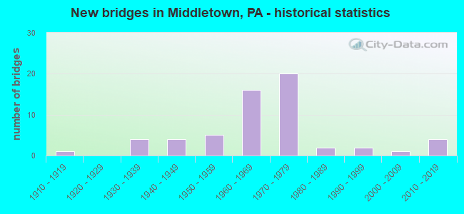
- New bridges - historical statistics
- 11910-1919
- 41930-1939
- 41940-1949
- 51950-1959
- 161960-1969
- 201970-1979
- 21980-1989
- 21990-1999
- 12000-2009
- 42010-2019
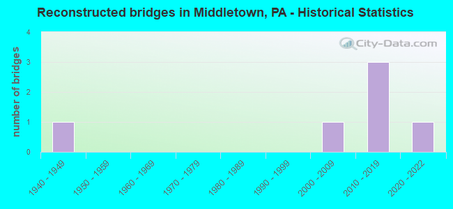
- Reconstructed bridges - Historical Statistics
- 11940-1949
- 01950-1959
- 01960-1969
- 01970-1979
- 01980-1989
- 01990-1999
- 12000-2009
- 32010-2019
- 12020-2022
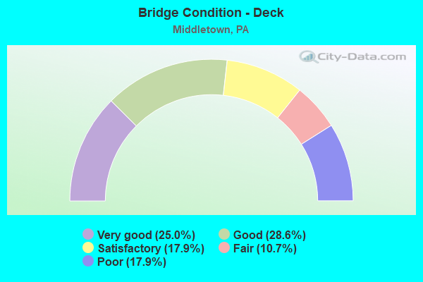
- Bridge Condition - Deck
- 25.0%Very good
- 28.6%Good
- 17.9%Satisfactory
- 10.7%Fair
- 17.9%Poor
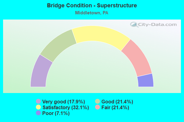
- Bridge Condition - Superstructure
- 17.9%Very good
- 21.4%Good
- 32.1%Satisfactory
- 21.4%Fair
- 7.1%Poor
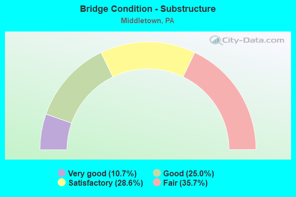
- Bridge Condition - Substructure
- 10.7%Very good
- 25.0%Good
- 28.6%Satisfactory
- 35.7%Fair
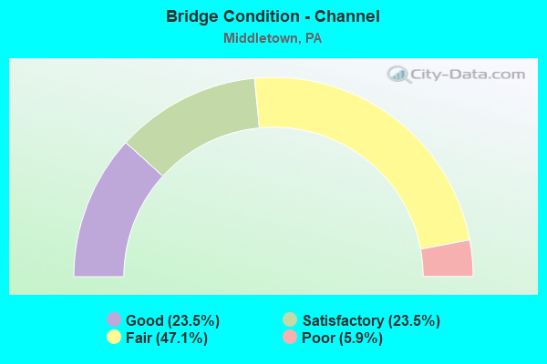
- Bridge Condition - Channel
- 23.5%Good
- 23.5%Satisfactory
- 47.1%Fair
- 5.9%Poor
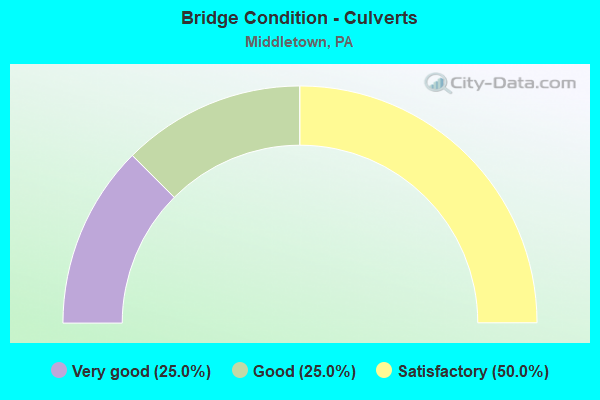
- Bridge Condition - Culverts
- 25.0%Very good
- 25.0%Good
- 50.0%Satisfactory
Find on map >> Show street view
Structure Number: 14456, Location: 2 MI.N. OF MIDDLETOWN (Lat: 40.224406, Lng: -76.719167), Route carried "under" structure: State highway 283, Year Built: 1971, Structure Length: 0. m, Average Daily Traffic: 21,609 (year 2021), Truck Traffic: 10%, Features Intersected: PA 283; SR 0300, Facility Carried by Structure: SR 2003
Minimum Vertical Clearance: 5.21m (17.09ft), Kilometerpoint: 6.338, Lanes on structure: 4, Lanes under structure: 4, Material/Design: Prestressed concrete, Design/Construction: Stringer/Multi-beam, Length of Maximum Span: 31.4m (103.0ft)
Find on map >> Show street view
Structure Number: 14456, Location: 2 MI.N. OF MIDDLETOWN (Lat: 40.224406, Lng: -76.719167), Route carried "under" structure: State highway 283, Year Built: 1971, Structure Length: 0. m, Average Daily Traffic: 20,232 (year 2021), Truck Traffic: 10%, Features Intersected: PA 283; SR 0300, Facility Carried by Structure: SR 2003
Minimum Vertical Clearance: 5.18m (16.99ft), Kilometerpoint: 6.320, Lanes on structure: 4, Lanes under structure: 4, Material/Design: Prestressed concrete, Design/Construction: Stringer/Multi-beam, Length of Maximum Span: 31.4m (103.0ft)
Find on map >> Show street view
Structure Number: 145, Location: 2.5 MI. E. MIDDLETOWN (Lat: 40.194403, Lng: -76.685336), Route carried "under" structure: State highway 283, Year Built: 1969, Structure Length: 0. m, Average Daily Traffic: 20,232 (year 2021), Truck Traffic: 10%, Features Intersected: PA 283; SR 0300, Facility Carried by Structure: SR 2023 TOLLHOUSE
Minimum Vertical Clearance: 5.08m (16.67ft), Kilometerpoint: 10.556, Lanes on structure: 2, Lanes under structure: 4, Material/Design: Steel continuous, Design/Construction: Stringer/Multi-beam, Length of Maximum Span: 33.5m (109.9ft)
Find on map >> Show street view
Structure Number: 145, Location: 2.5 MI. E. MIDDLETOWN (Lat: 40.194403, Lng: -76.685336), Route carried "under" structure: State highway 283, Year Built: 1969, Structure Length: 0. m, Average Daily Traffic: 21,609 (year 2021), Truck Traffic: 10%, Features Intersected: PA 283; SR 0300, Facility Carried by Structure: SR 2023 TOLLHOUSE
Minimum Vertical Clearance: 5.08m (16.67ft), Kilometerpoint: 10.728, Lanes on structure: 2, Lanes under structure: 4, Material/Design: Steel continuous, Design/Construction: Stringer/Multi-beam, Length of Maximum Span: 33.5m (109.9ft)
Find on map >> Show street view
Structure Number: 14564, Location: 1.5 MI. N.E. OF HIGHSPIRE (Lat: 40.210678, Lng: -76.752678), Route carried "under" structure: Interstate 76, Year Built: 1976, Structure Length: 0. m, Average Daily Traffic: 29,356 (year 2001), Truck Traffic: 21%, Features Intersected: I-76; SR 9076, Facility Carried by Structure: SR 3032 AIRPORT CN
Minimum Vertical Clearance: 5.52m (18.11ft), Kilometerpoint: 0.000, Lanes on structure: 4, Lanes under structure: 4, Material/Design: Steel, Design/Construction: Stringer/Multi-beam, Length of Maximum Span: 37.5m (123.0ft)
Find on map >> Show street view
Structure Number: 14566, Location: 1.5 MI. N. HIGHSPIRE (Lat: 40.216667, Lng: -76.750000), Route carried "under" structure: Spur State highway , Year Built: 1976, Structure Length: 0. m, Average Daily Traffic: 7,684 (year 2021), Truck Traffic: 7%, Features Intersected: SR 3032, Facility Carried by Structure: SR 2042;TWP RD 337
Minimum Vertical Clearance: 5.23m (17.16ft), Kilometerpoint: 2.311, Lanes on structure: 2, Lanes under structure: 4, Material/Design: Steel, Design/Construction: Stringer/Multi-beam, Length of Maximum Span: 45.1m (148.0ft)
Find on map >> Show street view
Structure Number: 14566, Location: 1.5 MI. N. HIGHSPIRE (Lat: 40.216667, Lng: -76.750000), Route carried "under" structure: Spur State highway , Year Built: 1976, Structure Length: 0. m, Average Daily Traffic: 6,302 (year 2021), Truck Traffic: 7%, Features Intersected: SR 3032, Facility Carried by Structure: SR 2042;TWP RD 337
Minimum Vertical Clearance: 5.23m (17.16ft), Kilometerpoint: 2.290, Lanes on structure: 2, Lanes under structure: 4, Material/Design: Steel, Design/Construction: Stringer/Multi-beam, Length of Maximum Span: 45.1m (148.0ft)
Find on map >> Show street view
Structure Number: 14614, Location: Londonderry Township (Lat: 40.210100, Lng: -76.735906), Route carried "under" structure: Interstate 76, Year Built: 1950, Structure Length: 0. m, Average Daily Traffic: 24,423 (year 2001), Truck Traffic: 24%, Features Intersected: PA TPK (I-76), Facility Carried by Structure: SR 0441, LR 618
Minimum Vertical Clearance: 4.70m (15.42ft), Kilometerpoint: 0.000, Lanes on structure: 2, Lanes under structure: 4, Material/Design: Concrete, Design/Construction: Frame, Length of Maximum Span: 23.8m (78.1ft)
Find on map >> Show street view
Structure Number: 14618, Location: LONDONDERRY TOWNSHIP (Lat: 40.206278, Lng: -76.693169), Route carried "under" structure: Interstate 76, Year Built: 1950, Structure Length: 0. m, Average Daily Traffic: 24,423 (year 2001), Truck Traffic: 24%, Features Intersected: PA TPK (I-76), Facility Carried by Structure: SR 2005, LR 22015
Minimum Vertical Clearance: 5.09m (16.70ft), Kilometerpoint: 0.000, Lanes on structure: 2, Lanes under structure: 4, Material/Design: Steel, Design/Construction: Girder and Floorbeam System, Length of Maximum Span: 29.6m (97.1ft)
Find on map >> Show street view
Structure Number: 1462, Location: LONDONDERRY TWP (Lat: 40.204583, Lng: -76.678667), Route carried "under" structure: State highway , Year Built: 1949, Structure Length: 0. m, Average Daily Traffic: 792 (year 2021), Truck Traffic: 5%, Features Intersected: LR22072,SR2002, Facility Carried by Structure: PA TPK (I-76)
Minimum Vertical Clearance: 4.97m (16.31ft), Kilometerpoint: 4.572, Lanes on structure: 2, Lanes under structure: 2, Material/Design: Concrete, Design/Construction: Tee Beam, Length of Maximum Span: 11.9m (39.0ft)
Find on map >> Show street view
Structure Number: 14778, Location: 1 MI. E. HIGHSPIRE (Lat: 40.200000, Lng: -76.733333), Route carried "under" structure: State highway 230, Year Built: 1976, Structure Length: 0. m, Average Daily Traffic: 5,979 (year 2020), Truck Traffic: 8%, Features Intersected: PA 230,AMTRAK,AIRPT. DR, Facility Carried by Structure: SR 8018; RAMP L
Minimum Vertical Clearance: 9.97m (32.71ft), Kilometerpoint: 14.507, Lanes on structure: 2, Lanes under structure: 4, Material/Design: Steel continuous, Design/Construction: Stringer/Multi-beam, Length of Maximum Span: 52.4m (171.9ft)
Find on map >> Show street view
Structure Number: 14778, Location: 1 MI. E. HIGHSPIRE (Lat: 40.200000, Lng: -76.733333), Route carried "under" structure: State highway 230, Year Built: 1976, Structure Length: 0. m, Average Daily Traffic: 5,564 (year 2020), Truck Traffic: 8%, Features Intersected: PA 230,AMTRAK,AIRPT. DR, Facility Carried by Structure: SR 8018; RAMP L
Minimum Vertical Clearance: 10.18m (33.40ft), Kilometerpoint: 14.507, Lanes on structure: 2, Lanes under structure: 4, Material/Design: Steel continuous, Design/Construction: Stringer/Multi-beam, Length of Maximum Span: 52.4m (171.9ft)
Find on map >> Show street view
Structure Number: 14778, Location: 1 MI. E. HIGHSPIRE (Lat: 40.200000, Lng: -76.733333), Route carried "under" structure: City street , Year Built: 1976, Structure Length: 0. m, Average Daily Traffic: 1 (year 2004), Features Intersected: PA 230,AMTRAK,AIRPT. DR, Facility Carried by Structure: SR 8018; RAMP L
Minimum Vertical Clearance: 9.42m (30.91ft), Kilometerpoint: 0.000, Lanes on structure: 2, Lanes under structure: 4, Material/Design: Steel continuous, Design/Construction: Stringer/Multi-beam, Length of Maximum Span: 52.4m (171.9ft)
Find on map >> Show street view
Structure Number: 5433, Location: Lower Swatara Twp. (Lat: 40.209922, Lng: -76.722708), Route carried "under" structure: Business State highway , Year Built: 2016, Structure Length: 0. m, Average Daily Traffic: 9,086 (year 2022), Truck Traffic: 4%, Features Intersected: LR22016, SR2003, Facility Carried by Structure: PA TPK (I-76)
Minimum Vertical Clearance: 4.83m (15.85ft), Kilometerpoint: 0.967, Lanes on structure: 4, Lanes under structure: 2, Material/Design: Prestressed concrete, Design/Construction: Box Beam or Girders - Single/Spread, Length of Maximum Span: 17.7m (58.1ft)