Bridge Statistics for Milan, Michigan (MI)
Condition, Traffic, Stress, Structural Evaluation, Project Costs
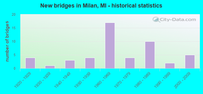
- New bridges - historical statistics
- 41920-1929
- 11930-1939
- 31940-1949
- 41950-1959
- 171960-1969
- 41970-1979
- 101980-1989
- 21990-1999
- 52000-2009

- Reconstructed bridges - Historical Statistics
- 11960-1969
- 01970-1979
- 31980-1989
- 11990-1999
- 22000-2009


- Bridge Condition - Deck
- 6.5%Excellent
- 6.5%Very good
- 16.1%Good
- 38.7%Satisfactory
- 22.6%Fair
- 9.7%Poor

- Bridge Condition - Superstructure
- 6.3%Excellent
- 6.3%Very good
- 18.8%Good
- 31.3%Satisfactory
- 25.0%Fair
- 9.4%Poor
- 3.1%Serious

- Bridge Condition - Substructure
- 3.1%Excellent
- 6.3%Very good
- 21.9%Good
- 40.6%Satisfactory
- 15.6%Fair
- 12.5%Poor

- Bridge Condition - Channel
- 9.7%Very good
- 9.7%Good
- 25.8%Satisfactory
- 38.7%Fair
- 12.9%Poor
- 3.2%Serious

- Bridge Condition - Culverts
- 50.0%Good
- 37.5%Satisfactory
- 12.5%Fair
Find on map >> Show street view
Structure Number: 13929, Location: YORK TWP SEC 25 (Lat: 42.105306, Lng: -83.662194), Route carried "on" structure: County highway , Year Built: 1975, Status: Open, Structure Length: 0.73m (2.40ft), Average Daily Traffic: 50 (year 2014), Average Future Daily Traffic: 57 (year 2034), Features Intersected: MCINTYRE DRAIN, Facility Carried by Structure: SANFORD ROAD
Minimum Vertical Clearance: 30.48m (100.00ft), Kilometerpoint: 2.305, Lanes on structure: 2, Owner: County Highway Agency, Approaching Roadway Width: 7.3m (24.0ft), Material/Design: Steel, Design/Construction: Culvert, Number Of Spans In Main Unit: 2, Length of Maximum Span: 3.0m (9.8ft), Curb-To-Curb Width: 9.1m (29.9ft), Out-to-Out Width: 12.2m (40.0ft)
Condition: Channel: Fair, Culverts: Satisfactory, Operating Rating: 97.2 metric tons, Method Used To Determine Operating Rating: Load Factor (LF) rating reported by rating factor (RF) method using MS18 loading, Inventory Rating: 97.2 metric tons, Method Used To Determine Inventory Rating: Load Factor (LF) rating reported by rating factor (RF) method using MS18 loading, Structural Evaluation: Equal to present minimum criteria, Deck Geometry: Better than present minimum criteria, Waterway Adequacy: Equal to present minimum criteria, Approach Roadway Alignment: Equal to present desirable criteria, Designated Inspection Frequency: Every 24 months, Inspection Date: September 2021, Wearing Surface/Protective System: Wearing Surface: Bituminous
Find on map >> Show street view
Structure Number: 7084, Location: 5.2 MI N OF M-50 (Lat: 42.033475, Lng: -83.676392), Route carried "under" structure: US 23, Year Built: 1961, Structure Length: 0. m, Average Daily Traffic: 35,138 (year 2007), Truck Traffic: 17%, Features Intersected: US-23, Facility Carried by Structure: CONE RD
Minimum Vertical Clearance: 4.40m (14.44ft), Kilometerpoint: 35.227, Lanes on structure: 2, Lanes under structure: 4, Material/Design: Steel, Design/Construction: Stringer/Multi-beam, Length of Maximum Span: 25.0m (82.0ft)
Find on map >> Show street view
Structure Number: 7085, Location: 1.6 MI S OF WASHTENAW COL (Lat: 42.062603, Lng: -83.670158), Route carried "under" structure: US 23, Year Built: 1961, Structure Length: 0. m, Average Daily Traffic: 35,138 (year 2007), Truck Traffic: 17%, Features Intersected: US-23, Facility Carried by Structure: SHERMAN RD
Minimum Vertical Clearance: 4.37m (14.34ft), Kilometerpoint: 38.597, Lanes on structure: 2, Lanes under structure: 4, Material/Design: Steel, Design/Construction: Stringer/Multi-beam, Length of Maximum Span: 21.6m (70.9ft)
Find on map >> Show street view
Structure Number: 7086, Location: 0.4 MI S OF WASHTENAW COL (Lat: 42.079283, Lng: -83.670700), Route carried "under" structure: US 23, Year Built: 1961, Structure Length: 0. m, Average Daily Traffic: 36,286 (year 2007), Truck Traffic: 15%, Features Intersected: US-23, Facility Carried by Structure: PLANK RD
Minimum Vertical Clearance: 4.44m (14.57ft), Kilometerpoint: 40.449, Lanes on structure: 2, Lanes under structure: 6, Material/Design: Steel, Design/Construction: Stringer/Multi-beam, Length of Maximum Span: 32.0m (105.0ft)
Find on map >> Show street view
Structure Number: 7087, Location: @ WASHTENAW CO LINE (Lat: 42.084325, Lng: -83.671778), Route carried "under" structure: US 23, Year Built: 1950, Structure Length: 0. m, Average Daily Traffic: 36,286 (year 2007), Truck Traffic: 15%, Features Intersected: US-23, Facility Carried by Structure: MILAN-OAKVILLE RD
Minimum Vertical Clearance: 5.18m (16.99ft), Kilometerpoint: 0.000, Lanes on structure: 2, Lanes under structure: 4, Material/Design: Steel, Design/Construction: Stringer/Multi-beam, Length of Maximum Span: 24.3m (79.7ft)
Find on map >> Show street view
Structure Number: 7088, Location: 2.5 MI S OF MILAN (Lat: 42.038883, Lng: -83.672322), Route carried "under" structure: US 23, Year Built: 1949, Structure Length: 0. m, Average Daily Traffic: 35,138 (year 2007), Truck Traffic: 17%, Features Intersected: US-23, Facility Carried by Structure: ANN ARBOR RR
Minimum Vertical Clearance: 4.57m (14.99ft), Kilometerpoint: 35.914, Lanes under structure: 4, Material/Design: Steel, Design/Construction: Girder and Floorbeam System, Length of Maximum Span: 33.2m (108.9ft)
Find on map >> Show street view
Structure Number: 10891, Location: 1.2 MI N OF MONROE COL (Lat: 42.100342, Lng: -83.676683), Route carried "under" structure: US 23, Year Built: 1962, Structure Length: 0. m, Average Daily Traffic: 41,226 (year 2007), Truck Traffic: 14%, Features Intersected: US-23, Facility Carried by Structure: CARPENTER RD
Minimum Vertical Clearance: 4.52m (14.83ft), Kilometerpoint: 1.909, Lanes on structure: 3, Lanes under structure: 5, Material/Design: Steel, Design/Construction: Stringer/Multi-beam, Length of Maximum Span: 39.1m (128.3ft)
Find on map >> Show street view
Structure Number: 10892, Location: 2.1 MI N OF MONROE COL (Lat: 42.113150, Lng: -83.682314), Route carried "under" structure: US 23, Year Built: 1962, Structure Length: 0. m, Average Daily Traffic: 41,226 (year 2007), Truck Traffic: 14%, Features Intersected: US-23, Facility Carried by Structure: WILLOW RD
Minimum Vertical Clearance: 4.50m (14.76ft), Kilometerpoint: 3.433, Lanes on structure: 2, Lanes under structure: 4, Material/Design: Prestressed concrete, Design/Construction: Stringer/Multi-beam, Length of Maximum Span: 21.2m (69.6ft)
Find on map >> Show street view
Structure Number: 10893, Location: 3.4 MI N OF MONROE COL (Lat: 42.131647, Lng: -83.682972), Route carried "under" structure: US 23, Year Built: 1962, Structure Length: 0. m, Average Daily Traffic: 41,226 (year 2007), Truck Traffic: 14%, Features Intersected: US-23, Facility Carried by Structure: STONY CREEK RD
Minimum Vertical Clearance: 4.60m (15.09ft), Kilometerpoint: 5.486, Lanes on structure: 2, Lanes under structure: 4, Material/Design: Steel, Design/Construction: Stringer/Multi-beam, Length of Maximum Span: 25.3m (83.0ft)
Find on map >> Show street view
Structure Number: 10894, Location: 3.5 MI S OF US-12 (Lat: 42.156872, Lng: -83.683853), Route carried "under" structure: US 23, Year Built: 1962, Structure Length: 0. m, Average Daily Traffic: 45,626 (year 2007), Truck Traffic: 12%, Features Intersected: US-23, Facility Carried by Structure: WILLIS RD
Minimum Vertical Clearance: 4.44m (14.57ft), Kilometerpoint: 8.288, Lanes on structure: 2, Lanes under structure: 5, Material/Design: Steel, Design/Construction: Stringer/Multi-beam, Length of Maximum Span: 24.7m (81.0ft)
Find on map >> Show street view
Structure Number: 10897, Location: IN MILAN (Lat: 42.085250, Lng: -83.672353), Route carried "under" structure: US 23, Year Built: 1951, Structure Length: 0. m, Average Daily Traffic: 36,286 (year 2007), Truck Traffic: 15%, Features Intersected: US-23, Facility Carried by Structure: NS RR
Minimum Vertical Clearance: 4.52m (14.83ft), Kilometerpoint: 0.113, Lanes under structure: 4, Material/Design: Steel, Design/Construction: Girder and Floorbeam System, Length of Maximum Span: 24.3m (79.7ft)