Bridge Statistics for Milford, Connecticut (CT)
Condition, Traffic, Stress, Structural Evaluation, Project Costs
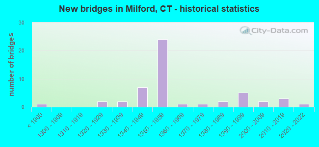
- New bridges - historical statistics
- 1Before 1900
- 21920-1929
- 21930-1939
- 71940-1949
- 241950-1959
- 11960-1969
- 11970-1979
- 21980-1989
- 51990-1999
- 22000-2009
- 32010-2019
- 12020-2022

- Reconstructed bridges - Historical Statistics
- 51980-1989
- 11990-1999
- 22000-2009


- Bridge Condition - Deck
- 7.1%Very good
- 50.0%Good
- 28.6%Satisfactory
- 7.1%Fair
- 7.1%Poor

- Bridge Condition - Superstructure
- 6.1%Very good
- 45.5%Good
- 21.2%Satisfactory
- 21.2%Fair
- 6.1%Poor

- Bridge Condition - Substructure
- 54.5%Good
- 36.4%Satisfactory
- 6.1%Fair
- 3.0%Poor

- Bridge Condition - Channel
- 12.5%Very good
- 31.3%Good
- 37.5%Satisfactory
- 12.5%Fair
- 6.3%Poor

- Bridge Condition - Culverts
- 25.0%Good
- 50.0%Satisfactory
- 25.0%Serious
Find on map >> Show street view
Structure Number: 135, Location: 0.3 MI W OF I95 EX 34 (Lat: 41.204936, Lng: -73.109406), Route carried "on" structure: Interstate 95, Year Built: 2017, Status: Open, Structure Length: 93.39m (306.40ft), Average Daily Traffic: 105,600 (year 2017), Truck Traffic: 14%, Average Future Daily Traffic: 156,911 (year 2037), Design Load: HL 93, Features Intersected: HOUSATONIC RIVER
Minimum Vertical Clearance: 30+ m (98+ ft), Kilometerpoint: 55.120, Lanes on structure: 6, Lanes under structure: 2, Base Highway Network: Yes, Owner: State Highway Agency, Approaching Roadway Width: 38.4m (126.0ft), Skew: 10 degrees, Navigation Control: Yes ( Vertical Clearance: 21.1m (69.2ft), Horizontal Clearance: 30.5m (100.1ft)), Material/Design: Steel continuous, Design/Construction: Stringer/Multi-beam, Number Of Spans In Main Unit: 14, Length of Maximum Span: 75.0m (246.1ft), Curb-To-Curb Width: 38.4m (126.0ft), Out-to-Out Width: 40.5m (132.9ft)
Condition: Deck: Good, Superstructure: Good, Substructure: Good, Channel: Good, Operating Rating: 48.9 metric tons, Method Used To Determine Operating Rating: Load and Resistance Factor Rating (LRFR) rating reported by rating factor(RF) method using HL-93 loadings, Inventory Rating: 37.6 metric tons, Method Used To Determine Inventory Rating: Load and Resistance Factor Rating (LRFR) rating reported by rating factor(RF) method using HL-93 loadings, Structural Evaluation: Better than present minimum criteria, Deck Geometry: Superior to present desirable criteria, Underclear: Somewhat better than minimum adequacy, Waterway Adequacy: Superior to present desirable criteria, Approach Roadway Alignment: Equal to present desirable criteria, Designated Inspection Frequency: Every 24 months, Underwater Inspection Frequency: Every 48 months, Inspection Date: May 2021, Underwater Inspection Date: May 2021, Deck Structure Type: Concrete Cast-file-Place, Wearing Surface/Protective System: Wearing Surface: Bituminous, Membrane: Preformed Fabric, Deck Protection: Epoxy Coated Reinforcing
Find on map >> Show street view
Structure Number: 136, Location: 1.7 MI N OF ROUTE 130 (Lat: 41.207997, Lng: -73.094428), Route carried "on" structure: Interstate 95, Year Built: 1957, Status: Open, Structure Length: 2.87m (9.42ft), Average Daily Traffic: 104,000 (year 2017), Truck Traffic: 9%, Average Future Daily Traffic: 154,534 (year 2037), Design Load: HS 20, Features Intersected: I-95 RAMPS 115 & 117
Minimum Vertical Clearance: 30+ m (98+ ft), Kilometerpoint: 56.922, Lanes on structure: 7, Lanes under structure: 2, Base Highway Network: Yes, Owner: State Highway Agency, Approaching Roadway Width: 32.9m (107.9ft), Skew: 31 degrees, Material/Design: Steel, Design/Construction: Stringer/Multi-beam, Number Of Spans In Main Unit: 1, Length of Maximum Span: 27.4m (89.9ft), Curb-To-Curb Width: 33.1m (108.6ft), Out-to-Out Width: 35.4m (116.1ft)
Condition: Deck: Good, Superstructure: Fair, Substructure: Good, Operating Rating: 44.4 metric tons, Method Used To Determine Operating Rating: Load and Resistance Factor Rating (LRFR) rating reported by rating factor(RF) method using HL-93 loadings, Inventory Rating: 34.0 metric tons, Method Used To Determine Inventory Rating: Load and Resistance Factor Rating (LRFR) rating reported by rating factor(RF) method using HL-93 loadings, Structural Evaluation: Somewhat better than minimum adequacy, Deck Geometry: Better than present minimum criteria, Underclear: High priority of corrective action, Approach Roadway Alignment: Equal to present desirable criteria, Designated Inspection Frequency: Every 24 months, Inspection Date: August 2021, Deck Structure Type: Concrete Cast-file-Place, Wearing Surface/Protective System: Wearing Surface: Bituminous, Membrane: Preformed Fabric
Find on map >> Show street view
Structure Number: 137, Location: 0.1 M S OF EX 35, I-95 (Lat: 41.210300, Lng: -73.090592), Route carried "on" structure: Interstate 95, Year Built: 1957, Year Reconstructed: 1991, Status: Open, Structure Length: 8.44m (27.69ft), Average Daily Traffic: 113,500 (year 2017), Truck Traffic: 14%, Average Future Daily Traffic: 168,650 (year 2037), Design Load: HS 20, Features Intersected: METRO NORTH RAILROAD
Minimum Vertical Clearance: 30+ m (98+ ft), Kilometerpoint: 57.309, Lanes on structure: 6, Base Highway Network: Yes, Owner: State Highway Agency, Approaching Roadway Width: 31.7m (104.0ft), Skew: 35 degrees, Material/Design: Steel continuous, Design/Construction: Stringer/Multi-beam, Number Of Spans In Main Unit: 3, Length of Maximum Span: 35.2m (115.5ft), Curb-To-Curb Width: 30.4m (99.7ft), Out-to-Out Width: 32.2m (105.6ft)
Condition: Deck: Satisfactory, Superstructure: Fair, Substructure: Fair, Operating Rating: 65.9 metric tons, Method Used To Determine Operating Rating: Load Factor (LF), Inventory Rating: 39.5 metric tons, Method Used To Determine Inventory Rating: Load Factor (LF), Structural Evaluation: Somewhat better than minimum adequacy, Deck Geometry: Superior to present desirable criteria, Underclear: Equal to present minimum criteria, Approach Roadway Alignment: Equal to present desirable criteria, Designated Inspection Frequency: Every 24 months, Inspection Date: Febuary 2021, Deck Structure Type: Concrete Cast-file-Place, Wearing Surface/Protective System: Wearing Surface: Bituminous, Membrane: Preformed Fabric, Deck Protection: Epoxy Coated Reinforcing
Find on map >> Show street view
Structure Number: 139, Location: 2.1 MI S OF ROUTE 121 (Lat: 41.216717, Lng: -73.083400), Route carried "on" structure: Interstate 95, Year Built: 1957, Year Reconstructed: 1995, Status: Open, Structure Length: 2.87m (9.42ft), Average Daily Traffic: 117,100 (year 2017), Truck Traffic: 14%, Average Future Daily Traffic: 173,999 (year 2037), Design Load: H 20, Features Intersected: WEST AVENUE
Minimum Vertical Clearance: 30+ m (98+ ft), Kilometerpoint: 58.274, Lanes on structure: 6, Lanes under structure: 2, Base Highway Network: Yes, Owner: State Highway Agency, Approaching Roadway Width: 36.0m (118.1ft), Skew: 35 degrees, Material/Design: Steel, Design/Construction: Stringer/Multi-beam, Number Of Spans In Main Unit: 1, Length of Maximum Span: 25.6m (84.0ft), Curb-To-Curb Width: 35.9m (117.8ft), Out-to-Out Width: 38.9m (127.6ft)
Condition: Deck: Good, Superstructure: Satisfactory, Substructure: Satisfactory, Operating Rating: 98.9 metric tons, Method Used To Determine Operating Rating: Load Factor (LF), Inventory Rating: 59.3 metric tons, Method Used To Determine Inventory Rating: Load Factor (LF), Structural Evaluation: Equal to present minimum criteria, Deck Geometry: Superior to present desirable criteria, Underclear: High priority of corrective action, Approach Roadway Alignment: Equal to present desirable criteria, Designated Inspection Frequency: Every 24 months, Inspection Date: January 2021, Deck Structure Type: Concrete Cast-file-Place, Wearing Surface/Protective System: Wearing Surface: Bituminous, Membrane: Preformed Fabric, Deck Protection: Epoxy Coated Reinforcing
Find on map >> Show street view
Structure Number: 14, Location: 0.9 MI S OF SR 796 (Lat: 41.222367, Lng: -73.078653), Route carried "on" structure: City street , Year Built: 1957, Status: Open, Structure Length: 5.70m (18.70ft), Average Daily Traffic: 13,830 (year 2019), Truck Traffic: 4%, Average Future Daily Traffic: 20,550 (year 2039), Design Load: HS 20, Features Intersected: INTERSTATE-95, Facility Carried by Structure: PLAINS ROAD NO. 1
Minimum Vertical Clearance: 30+ m (98+ ft), Kilometerpoint: 2.012, Lanes on structure: 3, Lanes under structure: 6, Owner: State Highway Agency, Approaching Roadway Width: 13.4m (44.0ft), Skew: 3 degrees, Material/Design: Steel, Design/Construction: Stringer/Multi-beam, Number Of Spans In Main Unit: 2, Length of Maximum Span: 27.4m (89.9ft), Curb or Sidewalk Widths: Left: 1.5m (4.9ft), Right: 1.5m (4.9ft), Curb-To-Curb Width: 13.4m (44.0ft), Out-to-Out Width: 17.3m (56.8ft)
Condition: Deck: Satisfactory, Superstructure: Fair, Substructure: Satisfactory, Operating Rating: 44.1 metric tons, Method Used To Determine Operating Rating: Load and Resistance Factor Rating (LRFR) rating reported by rating factor(RF) method using HL-93 loadings, Inventory Rating: 33.7 metric tons, Method Used To Determine Inventory Rating: Load and Resistance Factor Rating (LRFR) rating reported by rating factor(RF) method using HL-93 loadings, Structural Evaluation: Somewhat better than minimum adequacy, Deck Geometry: Somewhat better than minimum adequacy, Underclear: High priority of corrective action, Approach Roadway Alignment: Equal to present desirable criteria, Designated Inspection Frequency: Every 24 months, Inspection Date: June 2020, Deck Structure Type: Concrete Cast-file-Place, Wearing Surface/Protective System: Wearing Surface: Bituminous, Membrane: Preformed Fabric
Find on map >> Show street view
Structure Number: 141, Location: 1.3 MI S OF ROUTE 121 (Lat: 41.226533, Lng: -73.075814), Route carried "on" structure: Interstate 95, Year Built: 1957, Year Reconstructed: 1989, Status: Open, Structure Length: 1.59m (5.22ft), Average Daily Traffic: 122,200 (year 2017), Truck Traffic: 14%, Average Future Daily Traffic: 181,577 (year 2037), Design Load: H 20, Features Intersected: FORD STREET
Minimum Vertical Clearance: 30+ m (98+ ft), Kilometerpoint: 59.546, Lanes on structure: 6, Lanes under structure: 2, Base Highway Network: Yes, Owner: State Highway Agency, Approaching Roadway Width: 36.0m (118.1ft), Skew: 30 degrees, Material/Design: Steel, Design/Construction: Stringer/Multi-beam, Number Of Spans In Main Unit: 1, Length of Maximum Span: 14.3m (46.9ft), Curb-To-Curb Width: 35.9m (117.8ft), Out-to-Out Width: 38.9m (127.6ft)
Condition: Deck: Good, Superstructure: Good, Substructure: Good, Operating Rating: 65.1 metric tons, Method Used To Determine Operating Rating: Load and Resistance Factor Rating (LRFR) rating reported by rating factor(RF) method using HL-93 loadings, Inventory Rating: 49.9 metric tons, Method Used To Determine Inventory Rating: Load and Resistance Factor Rating (LRFR) rating reported by rating factor(RF) method using HL-93 loadings, Structural Evaluation: Better than present minimum criteria, Deck Geometry: Superior to present desirable criteria, Underclear: Meets minimum limits, Approach Roadway Alignment: Equal to present desirable criteria, Designated Inspection Frequency: Every 24 months, Inspection Date: January 2021, Deck Structure Type: Concrete Cast-file-Place, Wearing Surface/Protective System: Wearing Surface: Bituminous, Membrane: Preformed Fabric, Deck Protection: Epoxy Coated Reinforcing
Find on map >> Show street view
Structure Number: 142, Location: 0.1 MI S OF SR 796 (Lat: 41.231858, Lng: -73.071258), Route carried "on" structure: City street , Year Built: 1957, Status: Open, Structure Length: 6.22m (20.41ft), Average Daily Traffic: 9,962 (year 2020), Truck Traffic: 5%, Average Future Daily Traffic: 14,803 (year 2040), Design Load: HS 20, Features Intersected: I-95 & I-95 SB TR 807, Facility Carried by Structure: HIGH STREET
Minimum Vertical Clearance: 30+ m (98+ ft), Kilometerpoint: 0.016, Lanes on structure: 2, Lanes under structure: 7, Owner: State Highway Agency, Approaching Roadway Width: 11.6m (38.1ft), Material/Design: Steel, Design/Construction: Stringer/Multi-beam, Number Of Spans In Main Unit: 2, Length of Maximum Span: 30.2m (99.1ft), Curb or Sidewalk Widths: Left: 1.5m (4.9ft), Right: 1.5m (4.9ft), Curb-To-Curb Width: 11.6m (38.1ft), Out-to-Out Width: 15.4m (50.5ft)
Condition: Deck: Satisfactory, Superstructure: Satisfactory, Substructure: Satisfactory, Operating Rating: 56.1 metric tons, Method Used To Determine Operating Rating: Load and Resistance Factor Rating (LRFR) rating reported by rating factor(RF) method using HL-93 loadings, Inventory Rating: 43.1 metric tons, Method Used To Determine Inventory Rating: Load and Resistance Factor Rating (LRFR) rating reported by rating factor(RF) method using HL-93 loadings, Structural Evaluation: Equal to present minimum criteria, Deck Geometry: Somewhat better than minimum adequacy, Underclear: High priority of corrective action, Approach Roadway Alignment: Meets minimum limits, Designated Inspection Frequency: Every 24 months, Inspection Date: Febuary 2021, Deck Structure Type: Concrete Cast-file-Place, Wearing Surface/Protective System: Wearing Surface: Bituminous, Membrane: Built-up
Find on map >> Show street view
Structure Number: 143, Location: I-95 EXIT NO 38 (Lat: 41.233336, Lng: -73.069206), Route carried "on" structure: Interstate 95, Year Built: 1957, Status: Open, Structure Length: 5.33m (17.49ft), Average Daily Traffic: 124,400 (year 2017), Truck Traffic: 14%, Average Future Daily Traffic: 184,846 (year 2037), Design Load: HS 20, Features Intersected: SR 796 (MILFORD PARKWAY)
Minimum Vertical Clearance: 30+ m (98+ ft), Kilometerpoint: 60.479, Lanes on structure: 7, Lanes under structure: 4, Base Highway Network: Yes, Owner: State Highway Agency, Approaching Roadway Width: 32.3m (106.0ft), Skew: 32 degrees, Material/Design: Steel, Design/Construction: Stringer/Multi-beam, Number Of Spans In Main Unit: 2, Length of Maximum Span: 26.5m (86.9ft), Curb-To-Curb Width: 41.1m (134.8ft), Out-to-Out Width: 44.1m (144.7ft)
Condition: Deck: Satisfactory, Superstructure: Fair, Substructure: Satisfactory, Operating Rating: 29.8 metric tons, Method Used To Determine Operating Rating: Load and Resistance Factor Rating (LRFR) rating reported by rating factor(RF) method using HL-93 loadings, Inventory Rating: 23.0 metric tons, Method Used To Determine Inventory Rating: Load and Resistance Factor Rating (LRFR) rating reported by rating factor(RF) method using HL-93 loadings, Structural Evaluation: Somewhat better than minimum adequacy, Deck Geometry: Superior to present desirable criteria, Underclear: High priority of corrective action, Approach Roadway Alignment: Superior to present desirable criteria, Designated Inspection Frequency: Every 24 months, Inspection Date: May 2021, Deck Structure Type: Concrete Cast-file-Place, Wearing Surface/Protective System: Wearing Surface: Bituminous, Membrane: Built-up
Find on map >> Show street view
Structure Number: 145, Location: 325 FT S OF ROUTE 121 (Lat: 41.237397, Lng: -73.058008), Route carried "on" structure: Interstate 95, Year Built: 1958, Status: Open, Structure Length: 1.55m (5.09ft), Average Daily Traffic: 131,900 (year 2017), Truck Traffic: 14%, Average Future Daily Traffic: 195,990 (year 2037), Design Load: H 20, Features Intersected: WEPAWAUG RIVER
Minimum Vertical Clearance: 30+ m (98+ ft), Kilometerpoint: 61.557, Lanes on structure: 6, Base Highway Network: Yes, Owner: State Highway Agency, Approaching Roadway Width: 38.1m (125.0ft), Skew: 31 degrees, Material/Design: Concrete continuous, Design/Construction: Culvert, Number Of Spans In Main Unit: 3, Length of Maximum Span: 4.9m (16.1ft)
Condition: Channel: Fair, Culverts: Satisfactory, Structural Evaluation: Equal to present minimum criteria, Waterway Adequacy: Equal to present minimum criteria, Approach Roadway Alignment: Equal to present desirable criteria, Designated Inspection Frequency: Every 24 months, Inspection Date: November 2020
Find on map >> Show street view
Structure Number: 146, Location: 0.8 MI S OF US ROUTE 1 (Lat: 41.237442, Lng: -73.056850), Route carried "on" structure: Interstate 95, Year Built: 1958, Year Reconstructed: 1994, Status: Open, Structure Length: 1.74m (5.71ft), Average Daily Traffic: 131,900 (year 2017), Truck Traffic: 9%, Average Future Daily Traffic: 195,990 (year 2037), Design Load: H 20, Features Intersected: ROUTE 121
Minimum Vertical Clearance: 30+ m (98+ ft), Kilometerpoint: 61.654, Lanes on structure: 6, Lanes under structure: 2, Base Highway Network: Yes, Owner: State Highway Agency, Approaching Roadway Width: 38.1m (125.0ft), Skew: 30 degrees, Material/Design: Steel, Design/Construction: Stringer/Multi-beam, Number Of Spans In Main Unit: 1, Length of Maximum Span: 15.9m (52.2ft), Curb-To-Curb Width: 38.1m (125.0ft), Out-to-Out Width: 41.0m (134.5ft)
Condition: Deck: Fair, Superstructure: Good, Substructure: Satisfactory, Operating Rating: 64.2 metric tons, Method Used To Determine Operating Rating: Load and Resistance Factor Rating (LRFR) rating reported by rating factor(RF) method using HL-93 loadings, Inventory Rating: 49.2 metric tons, Method Used To Determine Inventory Rating: Load and Resistance Factor Rating (LRFR) rating reported by rating factor(RF) method using HL-93 loadings, Structural Evaluation: Equal to present minimum criteria, Deck Geometry: Superior to present desirable criteria, Underclear: Somewhat better than minimum adequacy, Approach Roadway Alignment: Equal to present desirable criteria, Designated Inspection Frequency: Every 24 months, Inspection Date: Febuary 2021, Deck Structure Type: Concrete Cast-file-Place, Wearing Surface/Protective System: Wearing Surface: Bituminous, Membrane: Preformed Fabric
Find on map >> Show street view
Structure Number: 147, Location: 0.3 MI N OF ROUTE 121 (Lat: 41.236731, Lng: -73.050628), Route carried "on" structure: Interstate 95, Year Built: 1958, Status: Open, Structure Length: 2.07m (6.79ft), Average Daily Traffic: 131,900 (year 2017), Truck Traffic: 14%, Average Future Daily Traffic: 195,990 (year 2037), Design Load: H 20, Features Intersected: ORANGE AVENUE
Minimum Vertical Clearance: 30+ m (98+ ft), Kilometerpoint: 62.185, Lanes on structure: 6, Lanes under structure: 2, Base Highway Network: Yes, Owner: State Highway Agency, Approaching Roadway Width: 38.1m (125.0ft), Skew: 31 degrees, Material/Design: Steel, Design/Construction: Stringer/Multi-beam, Number Of Spans In Main Unit: 1, Length of Maximum Span: 19.2m (63.0ft), Curb-To-Curb Width: 38.1m (125.0ft), Out-to-Out Width: 41.0m (134.5ft)
Condition: Deck: Satisfactory, Superstructure: Good, Substructure: Good, Operating Rating: 87.1 metric tons, Method Used To Determine Operating Rating: Load Factor (LF), Inventory Rating: 52.2 metric tons, Method Used To Determine Inventory Rating: Load Factor (LF), Structural Evaluation: Better than present minimum criteria, Deck Geometry: Superior to present desirable criteria, Underclear: Meets minimum limits, Approach Roadway Alignment: Equal to present desirable criteria, Designated Inspection Frequency: Every 24 months, Inspection Date: Febuary 2021, Deck Structure Type: Concrete Cast-file-Place, Wearing Surface/Protective System: Wearing Surface: Bituminous, Membrane: Preformed Fabric
Find on map >> Show street view
Structure Number: 148, Location: .2 MI S OF US ROUTE 1 (Lat: 41.235558, Lng: -73.046417), Route carried "on" structure: City street , Year Built: 1958, Status: Open, Structure Length: 6.22m (20.41ft), Average Daily Traffic: 2,480 (year 2020), Truck Traffic: 5%, Average Future Daily Traffic: 3,685 (year 2040), Design Load: HS 20, Features Intersected: INTERSTATE-95, Facility Carried by Structure: FOREST ROAD
Minimum Vertical Clearance: 30+ m (98+ ft), Kilometerpoint: 0.435, Lanes on structure: 2, Lanes under structure: 6, Owner: State Highway Agency, Approaching Roadway Width: 9.1m (29.9ft), Skew: 1 degrees, Material/Design: Steel continuous, Design/Construction: Stringer/Multi-beam, Number Of Spans In Main Unit: 2, Length of Maximum Span: 33.5m (109.9ft), Curb or Sidewalk Widths: Left: 1.5m (4.9ft), Right: 1.5m (4.9ft), Curb-To-Curb Width: 9.1m (29.9ft), Out-to-Out Width: 13.0m (42.7ft)
Condition: Deck: Satisfactory, Superstructure: Satisfactory, Substructure: Good, Operating Rating: 36.6 metric tons, Method Used To Determine Operating Rating: Load and Resistance Factor Rating (LRFR) rating reported by rating factor(RF) method using HL-93 loadings, Inventory Rating: 28.2 metric tons, Method Used To Determine Inventory Rating: Load and Resistance Factor Rating (LRFR) rating reported by rating factor(RF) method using HL-93 loadings, Structural Evaluation: Equal to present minimum criteria, Deck Geometry: Meets minimum limits, Underclear: High priority of corrective action, Approach Roadway Alignment: Equal to present minimum criteria, Designated Inspection Frequency: Every 24 months, Inspection Date: November 2020, Deck Structure Type: Concrete Cast-file-Place, Wearing Surface/Protective System: Wearing Surface: Bituminous, Membrane: Preformed Fabric
Find on map >> Show street view
Structure Number: 327, Location: AT STRATFORD TOWN LINE (Lat: 41.200289, Lng: -73.110486), Route carried "on" structure: US 1, Year Built: 1921, Year Reconstructed: 2006, Status: Open, Structure Length: 26.73m (87.70ft), Average Daily Traffic: 22,300 (year 2016), Truck Traffic: 6%, Average Future Daily Traffic: 33,136 (year 2036), Design Load: HS 20, Features Intersected: HOUSATONIC RIVER
Minimum Vertical Clearance: 30+ m (98+ ft), Kilometerpoint: 56.762, Lanes on structure: 4, Base Highway Network: Yes, Owner: State Highway Agency, Approaching Roadway Width: 14.6m (47.9ft), Navigation Control: Yes ( Vertical Clearance: 9.8m (32.2ft), Horizontal Clearance: 38.1m (125.0ft)), Material/Design: Steel, Design/Construction: Movable - Bascule, Number Of Spans In Main Unit: 1, Number Of Approach Spans: 9, Length of Maximum Span: 55.8m (183.1ft), Curb or Sidewalk Widths: Left: 1.8m (5.9ft), Right: 1.8m (5.9ft), Curb-To-Curb Width: 14.6m (47.9ft), Out-to-Out Width: 18.9m (62.0ft)
Condition: Deck: Poor, Superstructure: Poor, Substructure: Fair, Channel: Fair, Operating Rating: 54.5 metric tons, Method Used To Determine Operating Rating: Load Factor (LF), Inventory Rating: 32.7 metric tons, Method Used To Determine Inventory Rating: Load Factor (LF), Structural Evaluation: Meets minimum limits, Deck Geometry: High priority of replacement, Waterway Adequacy: Equal to present desirable criteria, Approach Roadway Alignment: Equal to present desirable criteria, Designated Inspection Frequency: Every 24 months, Critical Feature Inspection Frequency: Every 24 months, Underwater Inspection Frequency: Every 24 months, Inspection Date: October 2020, Critical Feature Inspection Date: October 2020, Underwater Inspection Date: October 2020, Total Project Cost: $17,100,000 ( Estimate for 2017), Deck Structure Type: Concrete Cast-file-Place, Wearing Surface/Protective System: Wearing Surface: Bituminous, Membrane: Built-up, Deck Protection: Epoxy Coated Reinforcing
Find on map >> Show street view
Structure Number: 33, Location: 425 FT S OF ROUTE 121 (Lat: 41.232411, Lng: -73.057717), Route carried "on" structure: US 1, Year Built: 2016, Status: Open, Structure Length: 2.32m (7.61ft), Average Daily Traffic: 21,200 (year 2016), Truck Traffic: 4%, Average Future Daily Traffic: 31,501 (year 2036), Design Load: HL 93, Features Intersected: WEPAWAUG RIVER
Minimum Vertical Clearance: 30+ m (98+ ft), Kilometerpoint: 62.958, Lanes on structure: 4, Base Highway Network: Yes, Owner: State Highway Agency, Approaching Roadway Width: 17.1m (56.1ft), Material/Design: Steel continuous, Design/Construction: Stringer/Multi-beam, Number Of Spans In Main Unit: 2, Length of Maximum Span: 10.7m (35.1ft), Curb or Sidewalk Widths: Left: 1.7m (5.6ft), Right: 1.7m (5.6ft), Curb-To-Curb Width: 17.1m (56.1ft), Out-to-Out Width: 21.2m (69.6ft)
Condition: Deck: Very good, Superstructure: Very good, Substructure: Good, Channel: Good, Operating Rating: 70.6 metric tons, Method Used To Determine Operating Rating: Load and Resistance Factor Rating (LRFR) rating reported by rating factor(RF) method using HL-93 loadings, Inventory Rating: 54.4 metric tons, Method Used To Determine Inventory Rating: Load and Resistance Factor Rating (LRFR) rating reported by rating factor(RF) method using HL-93 loadings, Structural Evaluation: Better than present minimum criteria, Deck Geometry: Somewhat better than minimum adequacy, Waterway Adequacy: Equal to present minimum criteria, Approach Roadway Alignment: Equal to present desirable criteria, Designated Inspection Frequency: Every 24 months, Inspection Date: October 2020, Deck Structure Type: Concrete Cast-file-Place, Wearing Surface/Protective System: Wearing Surface: Bituminous, Membrane: Other, Deck Protection: Epoxy Coated Reinforcing
Find on map >> Show street view
Structure Number: 762, Location: 0.8 MI N OF ROUTE 110 (Lat: 41.246872, Lng: -73.085183), Route carried "on" structure: State highway 15, Year Built: 1940, Year Reconstructed: 2005, Status: Open, Structure Length: 2.19m (7.19ft), Average Daily Traffic: 71,500 (year 2015), Truck Traffic: 1%, Average Future Daily Traffic: 106,242 (year 2035), Design Load: HS 20, Features Intersected: SR 796
Minimum Vertical Clearance: 30+ m (98+ ft), Kilometerpoint: 60.817, Lanes on structure: 5, Lanes under structure: 2, Base Highway Network: Yes, Owner: State Highway Agency, Approaching Roadway Width: 32.0m (105.0ft), Skew: 32 degrees, Material/Design: Prestressed concrete, Design/Construction: Box Beam or Girders - Multiple, Number Of Spans In Main Unit: 1, Length of Maximum Span: 20.4m (66.9ft), Curb or Sidewalk Widths: Left: 3.0m (9.8ft), Right: 0.0m, Curb-To-Curb Width: 32.0m (105.0ft), Out-to-Out Width: 38.5m (126.3ft)
Condition: Deck: Good, Superstructure: Satisfactory, Substructure: Satisfactory, Operating Rating: 66.1 metric tons, Method Used To Determine Operating Rating: Load and Resistance Factor Rating (LRFR) rating reported by rating factor(RF) method using HL-93 loadings, Inventory Rating: 50.9 metric tons, Method Used To Determine Inventory Rating: Load and Resistance Factor Rating (LRFR) rating reported by rating factor(RF) method using HL-93 loadings, Structural Evaluation: Equal to present minimum criteria, Deck Geometry: Superior to present desirable criteria, Underclear: High priority of corrective action, Approach Roadway Alignment: Equal to present desirable criteria, Designated Inspection Frequency: Every 24 months, Inspection Date: September 2020, Deck Structure Type: Other, Wearing Surface/Protective System: Wearing Surface: Bituminous, Membrane: Built-up, Deck Protection: Epoxy Coated Reinforcing
Find on map >> Show street view
Structure Number: 1328, Location: 1.3 MI E OF US ROUTE 1 (Lat: 41.222725, Lng: -73.055558), Route carried "on" structure: State highway 162, Year Built: 1889, Status: Open, Structure Length: 0.73m (2.40ft), Average Daily Traffic: 13,300 (year 2015), Truck Traffic: 3%, Average Future Daily Traffic: 19,762 (year 2035), Features Intersected: WEPAWAUG RIVER
Minimum Vertical Clearance: 30+ m (98+ ft), Kilometerpoint: 2.124, Lanes on structure: 2, Owner: State Highway Agency, Approaching Roadway Width: 9.4m (30.8ft), Material/Design: Masonry, Design/Construction: Arch - Deck, Number Of Spans In Main Unit: 1, Length of Maximum Span: 7.3m (24.0ft), Curb or Sidewalk Widths: Left: 1.5m (4.9ft), Right: 1.5m (4.9ft), Curb-To-Curb Width: 9.4m (30.8ft), Out-to-Out Width: 13.9m (45.6ft)
Condition: Superstructure: Fair, Substructure: Satisfactory, Channel: Very good, Operating Rating: 42.6 metric tons, Method Used To Determine Operating Rating: Field evaluation and documented engineering judgment, Inventory Rating: 32.7 metric tons, Method Used To Determine Inventory Rating: Field evaluation and documented engineering judgment, Structural Evaluation: Somewhat better than minimum adequacy, Deck Geometry: High priority of corrective action, Waterway Adequacy: Equal to present minimum criteria, Approach Roadway Alignment: Equal to present minimum criteria, Designated Inspection Frequency: Every 24 months, Inspection Date: March 2021, Wearing Surface/Protective System: Wearing Surface: Bituminous
Find on map >> Show street view
Structure Number: 1446, Location: 0.2 MI N OF I-95 (Lat: 41.235042, Lng: -73.072475), Route carried "on" structure: City street , Year Built: 1941, Status: Open, Structure Length: 3.23m (10.60ft), Average Daily Traffic: 8,064 (year 2019), Truck Traffic: 3%, Average Future Daily Traffic: 11,982 (year 2039), Design Load: H 20, Features Intersected: SR 796, Facility Carried by Structure: WHEELERS FARMS RD.
Minimum Vertical Clearance: 30+ m (98+ ft), Kilometerpoint: 0.322, Lanes on structure: 2, Lanes under structure: 4, Owner: State Highway Agency, Approaching Roadway Width: 9.1m (29.9ft), Skew: 3 degrees, Material/Design: Steel continuous, Design/Construction: Stringer/Multi-beam, Number Of Spans In Main Unit: 2, Length of Maximum Span: 15.5m (50.9ft), Curb or Sidewalk Widths: Left: 1.4m (4.6ft), Right: 0.3m (1.0ft), Curb-To-Curb Width: 10.1m (33.1ft), Out-to-Out Width: 12.3m (40.4ft)
Condition: Deck: Poor, Superstructure: Poor, Substructure: Poor, Operating Rating: 61.6 metric tons, Method Used To Determine Operating Rating: Load Factor (LF), Inventory Rating: 36.8 metric tons, Method Used To Determine Inventory Rating: Load Factor (LF), Structural Evaluation: Meets minimum limits, Deck Geometry: Meets minimum limits, Underclear: High priority of replacement, Approach Roadway Alignment: Equal to present minimum criteria, Designated Inspection Frequency: Every 24 months, Critical Feature Inspection Frequency: Every 24 months, Inspection Date: December 2019, Critical Feature Inspection Date: December 2019, Total Project Cost: $8,000,000 ( Estimate for 2015), Deck Structure Type: Concrete Cast-file-Place, Wearing Surface/Protective System: Wearing Surface: Monolithic Concrete
Find on map >> Show street view
Structure Number: 1447, Location: 0.2 MI N OF US ROUTE 1 (Lat: 41.231542, Lng: -73.063933), Route carried "on" structure: State highway 796, Year Built: 1940, Status: Posted for load-capacity, Structure Length: 1.01m (3.31ft), Average Daily Traffic: 6,200 (year 2015), Truck Traffic: 6%, Average Future Daily Traffic: 9,213 (year 2035), Features Intersected: MEADOW STREET
Minimum Vertical Clearance: 30+ m (98+ ft), Kilometerpoint: 0.354, Lanes on structure: 3, Lanes under structure: 2, Base Highway Network: Yes, Owner: State Highway Agency, Approaching Roadway Width: 16.5m (54.1ft), Skew: 31 degrees, Material/Design: Concrete, Design/Construction: Frame, Number Of Spans In Main Unit: 1, Length of Maximum Span: 10.1m (33.1ft), Curb-To-Curb Width: 16.5m (54.1ft), Out-to-Out Width: 19.3m (63.3ft)
Condition: Superstructure: Satisfactory, Substructure: Satisfactory, Operating Rating: 52.6 metric tons, Method Used To Determine Operating Rating: Field evaluation and documented engineering judgment, Inventory Rating: 30.8 metric tons, Method Used To Determine Inventory Rating: Field evaluation and documented engineering judgment, Structural Evaluation: Equal to present minimum criteria, Deck Geometry: Better than present minimum criteria, Underclear: High priority of corrective action, Approach Roadway Alignment: Equal to present desirable criteria, Designated Inspection Frequency: Every 24 months, Inspection Date: Febuary 2021
Find on map >> Show street view
Structure Number: 1663, Location: 0.4 MI E OF ROUTE 162 (Lat: 41.218178, Lng: -73.039214), Route carried "on" structure: State highway 736, Year Built: 1951, Status: Open, Structure Length: 2.29m (7.51ft), Average Daily Traffic: 5,700 (year 2015), Truck Traffic: 5%, Average Future Daily Traffic: 8,470 (year 2035), Design Load: HS 20, Features Intersected: GULF POND
Minimum Vertical Clearance: 30+ m (98+ ft), Kilometerpoint: 0.644, Lanes on structure: 2, Owner: State Highway Agency, Approaching Roadway Width: 10.7m (35.1ft), Material/Design: Steel, Design/Construction: Stringer/Multi-beam, Number Of Spans In Main Unit: 1, Length of Maximum Span: 21.3m (69.9ft), Curb or Sidewalk Widths: Left: 0.4m (1.3ft), Right: 1.5m (4.9ft), Curb-To-Curb Width: 10.7m (35.1ft), Out-to-Out Width: 13.5m (44.3ft)
Condition: Deck: Fair, Superstructure: Fair, Substructure: Satisfactory, Channel: Good, Operating Rating: 29.8 metric tons, Method Used To Determine Operating Rating: Load and Resistance Factor Rating (LRFR) rating reported by rating factor(RF) method using HL-93 loadings, Inventory Rating: 23.0 metric tons, Method Used To Determine Inventory Rating: Load and Resistance Factor Rating (LRFR) rating reported by rating factor(RF) method using HL-93 loadings, Structural Evaluation: Somewhat better than minimum adequacy, Deck Geometry: Meets minimum limits, Waterway Adequacy: Equal to present minimum criteria, Approach Roadway Alignment: Equal to present desirable criteria, Designated Inspection Frequency: Every 24 months, Inspection Date: July 2020, Deck Structure Type: Concrete Cast-file-Place, Wearing Surface/Protective System: Wearing Surface: Bituminous, Membrane: Preformed Fabric
Find on map >> Show street view
Structure Number: 3501, Location: 0.1 MI N OF US ROUTE 1 (Lat: 41.231775, Lng: -73.063906), Route carried "on" structure: Ramp State highway 796, Year Built: 1941, Status: Posted for load-capacity, Structure Length: 0.98m (3.22ft), Average Daily Traffic: 6,200 (year 2015), Truck Traffic: 1%, Average Future Daily Traffic: 9,213 (year 2035), Features Intersected: MEADOW STREET
Minimum Vertical Clearance: 30+ m (98+ ft), Kilometerpoint: 0.177, Lanes on structure: 1, Lanes under structure: 2, Owner: State Highway Agency, Approaching Roadway Width: 10.4m (34.1ft), Material/Design: Concrete, Design/Construction: Frame, Number Of Spans In Main Unit: 1, Length of Maximum Span: 9.8m (32.2ft), Curb-To-Curb Width: 10.4m (34.1ft), Out-to-Out Width: 12.5m (41.0ft)
Condition: Superstructure: Good, Substructure: Good, Operating Rating: 52.6 metric tons, Method Used To Determine Operating Rating: Field evaluation and documented engineering judgment, Inventory Rating: 30.8 metric tons, Method Used To Determine Inventory Rating: Field evaluation and documented engineering judgment, Structural Evaluation: Better than present minimum criteria, Deck Geometry: Superior to present desirable criteria, Underclear: High priority of corrective action, Approach Roadway Alignment: Equal to present desirable criteria, Designated Inspection Frequency: Every 48 months, Inspection Date: Febuary 2021
Find on map >> Show street view
Structure Number: 3645, Location: 0.2 MI E OF ROUTE 162 (Lat: 41.225489, Lng: -73.057111), Route carried "on" structure: City street , Year Built: 1934, Status: Open, Structure Length: 1.95m (6.40ft), Average Daily Traffic: 14,910 (year 2020), Truck Traffic: 5%, Average Future Daily Traffic: 22,155 (year 2040), Features Intersected: WEPAWAUG RIVER, Facility Carried by Structure: RIVER STREET
Minimum Vertical Clearance: 30+ m (98+ ft), Kilometerpoint: 0.000, Lanes on structure: 2, Owner: City or Municipal Highway Agency, Approaching Roadway Width: 9.1m (29.9ft), Material/Design: Concrete, Design/Construction: Arch - Deck, Number Of Spans In Main Unit: 3, Length of Maximum Span: 6.7m (22.0ft), Curb or Sidewalk Widths: Left: 1.2m (3.9ft), Right: 1.2m (3.9ft), Curb-To-Curb Width: 9.1m (29.9ft), Out-to-Out Width: 12.9m (42.3ft)
Condition: Superstructure: Good, Substructure: Satisfactory, Channel: Satisfactory, Operating Rating: 52.6 metric tons, Method Used To Determine Operating Rating: Field evaluation and documented engineering judgment, Inventory Rating: 30.8 metric tons, Method Used To Determine Inventory Rating: Field evaluation and documented engineering judgment, Structural Evaluation: Equal to present minimum criteria, Deck Geometry: High priority of corrective action, Waterway Adequacy: Better than present minimum criteria, Approach Roadway Alignment: Equal to present desirable criteria, Designated Inspection Frequency: Every 24 months, Inspection Date: June 2020
Find on map >> Show street view
Structure Number: 384, Location: 0.1 MI N OF BRIDGEPORT AV (Lat: 41.217597, Lng: -73.068936), Route carried "on" structure: City street , Year Built: 2006, Status: Open, Structure Length: 2.93m (9.61ft), Average Daily Traffic: 7,300 (year 2015), Truck Traffic: 5%, Average Future Daily Traffic: 10,847 (year 2035), Design Load: HS 20, Features Intersected: METRO NORTH RAILROAD, Facility Carried by Structure: CLARK STREET
Minimum Vertical Clearance: 30+ m (98+ ft), Kilometerpoint: 0.161, Lanes on structure: 2, Maintenance Responsibility: State Highway Agency, Approaching Roadway Width: 6.7m (22.0ft), Material/Design: Steel, Design/Construction: Girder and Floorbeam System, Number Of Spans In Main Unit: 1, Length of Maximum Span: 26.5m (86.9ft), Curb or Sidewalk Widths: Left: 0.0m, Right: 1.3m (4.3ft), Curb-To-Curb Width: 6.7m (22.0ft), Out-to-Out Width: 8.9m (29.2ft)
Condition: Deck: Good, Superstructure: Good, Substructure: Good, Inventory Rating: 63.0 metric tons, Method Used To Determine Inventory Rating: Load Factor (LF), Structural Evaluation: Better than present minimum criteria, Deck Geometry: High priority of replacement, Underclear: High priority of corrective action, Approach Roadway Alignment: Equal to present minimum criteria, Designated Inspection Frequency: Every 24 months, Critical Feature Inspection Frequency: Every 24 months, Inspection Date: Febuary 2021, Critical Feature Inspection Date: Febuary 2021, Deck Structure Type: Concrete Cast-file-Place, Wearing Surface/Protective System: Wearing Surface: Bituminous, Membrane: Built-up, Deck Protection: Galvanized Reinforcing
Find on map >> Show street view
Structure Number: 4093, Location: 0.3 MI N OF ROUTE 162 (Lat: 41.226511, Lng: -73.058311), Route carried "on" structure: City street , Year Built: 1928, Year Reconstructed: 1991, Status: Open, Structure Length: 1.62m (5.31ft), Average Daily Traffic: 8,075 (year 2018), Truck Traffic: 5%, Average Future Daily Traffic: 11,999 (year 2038), Design Load: HS 20, Features Intersected: WEPAWAUG RIVER, Facility Carried by Structure: WEST MAIN STREET
Minimum Vertical Clearance: 30+ m (98+ ft), Kilometerpoint: 1.384, Lanes on structure: 2, Owner: City or Municipal Highway Agency, Approaching Roadway Width: 7.3m (24.0ft), Material/Design: Prestressed concrete, Design/Construction: Slab, Number Of Spans In Main Unit: 1, Length of Maximum Span: 13.7m (44.9ft), Curb or Sidewalk Widths: Left: 2.5m (8.2ft), Right: 0.7m (2.3ft), Curb-To-Curb Width: 7.3m (24.0ft), Out-to-Out Width: 11.1m (36.4ft)
Condition: Deck: Good, Superstructure: Good, Substructure: Good, Channel: Satisfactory, Operating Rating: 39.2 metric tons, Method Used To Determine Operating Rating: Load and Resistance Factor Rating (LRFR) rating reported by rating factor(RF) method using HL-93 loadings, Inventory Rating: 30.5 metric tons, Method Used To Determine Inventory Rating: Load and Resistance Factor Rating (LRFR) rating reported by rating factor(RF) method using HL-93 loadings, Structural Evaluation: Better than present minimum criteria, Deck Geometry: High priority of replacement, Waterway Adequacy: Equal to present minimum criteria, Approach Roadway Alignment: Equal to present desirable criteria, Designated Inspection Frequency: Every 48 months, Underwater Inspection Frequency: Every 48 months, Inspection Date: August 2018, Underwater Inspection Date: August 2018, Deck Structure Type: Other, Wearing Surface/Protective System: Wearing Surface: Bituminous, Membrane: Built-up
Find on map >> Show street view
Structure Number: 4094, Location: 0.8 MI S OF ROUTE 162 (Lat: 41.210975, Lng: -73.046525), Route carried "on" structure: City street , Year Built: 2006, Status: Open, Structure Length: 3.81m (12.50ft), Average Daily Traffic: 5,080 (year 2020), Truck Traffic: 5%, Average Future Daily Traffic: 7,548 (year 2040), Design Load: HS 20, Features Intersected: GULF POND, Facility Carried by Structure: GULF STREET
Minimum Vertical Clearance: 30+ m (98+ ft), Kilometerpoint: 0.000, Lanes on structure: 2, Owner: City or Municipal Highway Agency, Approaching Roadway Width: 11.9m (39.0ft), Material/Design: Prestressed concrete, Design/Construction: Stringer/Multi-beam, Number Of Spans In Main Unit: 1, Length of Maximum Span: 36.0m (118.1ft), Curb or Sidewalk Widths: Left: 1.8m (5.9ft), Right: 1.8m (5.9ft), Curb-To-Curb Width: 12.0m (39.4ft), Out-to-Out Width: 16.3m (53.5ft)
Condition: Deck: Good, Superstructure: Good, Substructure: Good, Channel: Very good, Inventory Rating: 34.2 metric tons, Method Used To Determine Inventory Rating: Load Factor (LF), Structural Evaluation: Better than present minimum criteria, Deck Geometry: Somewhat better than minimum adequacy, Waterway Adequacy: Better than present minimum criteria, Approach Roadway Alignment: Better than present minimum criteria, Designated Inspection Frequency: Every 24 months, Inspection Date: July 2020, Deck Structure Type: Concrete Cast-file-Place, Wearing Surface/Protective System: Wearing Surface: Bituminous, Membrane: Built-up, Deck Protection: Epoxy Coated Reinforcing
Find on map >> Show street view
Structure Number: 494, Location: 0.2 MI S OF US ROUTE 1 (Lat: 41.230553, Lng: -73.057078), Route carried "on" structure: City street , Year Built: 1997, Status: Open, Structure Length: 2.32m (7.61ft), Average Daily Traffic: 680 (year 2020), Truck Traffic: 4%, Average Future Daily Traffic: 1,010 (year 2040), Design Load: HL 93, Features Intersected: WEPAWAUG RIVER, Facility Carried by Structure: BRIDGE STREET
Minimum Vertical Clearance: 30+ m (98+ ft), Kilometerpoint: 0.016, Lanes on structure: 2, Owner: City or Municipal Highway Agency, Approaching Roadway Width: 7.3m (24.0ft), Skew: 1 degrees, Material/Design: Prestressed concrete, Design/Construction: Box Beam or Girders - Multiple, Number Of Spans In Main Unit: 1, Length of Maximum Span: 21.6m (70.9ft), Curb or Sidewalk Widths: Left: 1.7m (5.6ft), Right: 0.0m, Curb-To-Curb Width: 7.3m (24.0ft), Out-to-Out Width: 10.8m (35.4ft)
Condition: Deck: Good, Superstructure: Good, Substructure: Good, Channel: Good, Operating Rating: 53.5 metric tons, Method Used To Determine Operating Rating: Load and Resistance Factor Rating (LRFR) rating reported by rating factor(RF) method using HL-93 loadings, Inventory Rating: 26.9 metric tons, Method Used To Determine Inventory Rating: Load and Resistance Factor Rating (LRFR) rating reported by rating factor(RF) method using HL-93 loadings, Structural Evaluation: Equal to present minimum criteria, Deck Geometry: Meets minimum limits, Waterway Adequacy: Somewhat better than minimum adequacy, Approach Roadway Alignment: Equal to present minimum criteria, Designated Inspection Frequency: Every 24 months, Underwater Inspection Frequency: Every 24 months, Inspection Date: September 2020, Underwater Inspection Date: September 2020, Deck Structure Type: Other, Wearing Surface/Protective System: Wearing Surface: Bituminous, Membrane: Built-up, Deck Protection: Epoxy Coated Reinforcing
Find on map >> Show street view
Structure Number: 4941, Location: 250 FT W OF ROUTE 121 (Lat: 41.236200, Lng: -73.058114), Route carried "on" structure: City street , Year Built: 1965, Status: Open, Structure Length: 1.55m (5.09ft), Average Daily Traffic: 960 (year 2020), Truck Traffic: 4%, Average Future Daily Traffic: 1,426 (year 2040), Features Intersected: WEPAWAUG RIVER, Facility Carried by Structure: WALNUT STREET
Minimum Vertical Clearance: 30+ m (98+ ft), Kilometerpoint: 0.000, Lanes on structure: 2, Owner: City or Municipal Highway Agency, Approaching Roadway Width: 9.1m (29.9ft), Skew: 2 degrees, Material/Design: Concrete continuous, Design/Construction: Culvert, Number Of Spans In Main Unit: 3, Length of Maximum Span: 4.9m (16.1ft), Curb or Sidewalk Widths: Left: 1.4m (4.6ft), Right: 1.4m (4.6ft), Curb-To-Curb Width: 9.1m (29.9ft), Out-to-Out Width: 12.8m (42.0ft)
Condition: Channel: Satisfactory, Culverts: Satisfactory, Operating Rating: 42.6 metric tons, Method Used To Determine Operating Rating: Field evaluation and documented engineering judgment, Inventory Rating: 32.7 metric tons, Method Used To Determine Inventory Rating: Field evaluation and documented engineering judgment, Structural Evaluation: Equal to present minimum criteria, Deck Geometry: Equal to present minimum criteria, Waterway Adequacy: Better than present minimum criteria, Approach Roadway Alignment: Better than present minimum criteria, Designated Inspection Frequency: Every 24 months, Inspection Date: June 2020
Find on map >> Show street view
Structure Number: 4942, Location: 660 FT W OF ROUTE 121 (Lat: 41.258897, Lng: -73.053622), Route carried "on" structure: City street , Year Built: 2020, Status: Open, Structure Length: 1.75m (5.74ft), Average Daily Traffic: 693 (year 2020), Truck Traffic: 3%, Average Future Daily Traffic: 1,030 (year 2040), Design Load: HL 93, Features Intersected: WEPAWAUG RIVER, Facility Carried by Structure: FLAX MILL LANE
Minimum Vertical Clearance: 30+ m (98+ ft), Kilometerpoint: 0.000, Lanes on structure: 2, Owner: City or Municipal Highway Agency, Approaching Roadway Width: 7.3m (24.0ft), Skew: 2 degrees, Material/Design: Prestressed concrete, Design/Construction: Slab, Number Of Spans In Main Unit: 1, Length of Maximum Span: 16.6m (54.5ft), Curb-To-Curb Width: 7.3m (24.0ft), Out-to-Out Width: 8.4m (27.6ft)
Condition: Deck: Very good, Superstructure: Very good, Substructure: Good, Channel: Good, Operating Rating: 86.5 metric tons, Method Used To Determine Operating Rating: Load and Resistance Factor Rating (LRFR) rating reported by rating factor(RF) method using HL-93 loadings, Inventory Rating: 66.7 metric tons, Method Used To Determine Inventory Rating: Load and Resistance Factor Rating (LRFR) rating reported by rating factor(RF) method using HL-93 loadings, Structural Evaluation: Better than present minimum criteria, Deck Geometry: Meets minimum limits, Waterway Adequacy: Equal to present desirable criteria, Approach Roadway Alignment: Equal to present desirable criteria, Designated Inspection Frequency: Every 24 months, Inspection Date: November 2020, Total Project Cost: $2,700,000 ( Estimate for 2016), Deck Structure Type: Concrete Cast-file-Place, Wearing Surface/Protective System: Wearing Surface: Bituminous, Membrane: Other, Deck Protection: Epoxy Coated Reinforcing
Find on map >> Show street view
Structure Number: 4943, Location: 0.2 MI SO. OF US ROUTE 1 (Lat: 41.228808, Lng: -73.057750), Route carried "on" structure: City street , Year Built: 1951, Status: Open, Structure Length: 1.49m (4.89ft), Average Daily Traffic: 530 (year 2020), Truck Traffic: 4%, Average Future Daily Traffic: 788 (year 2040), Features Intersected: WEPAWAUG RIVER, Facility Carried by Structure: MAPLE STREET
Minimum Vertical Clearance: 30+ m (98+ ft), Kilometerpoint: 0.000, Lanes on structure: 2, Owner: City or Municipal Highway Agency, Approaching Roadway Width: 6.7m (22.0ft), Material/Design: Steel, Design/Construction: Arch - Deck, Number Of Spans In Main Unit: 3, Length of Maximum Span: 4.6m (15.1ft), Curb or Sidewalk Widths: Left: 1.5m (4.9ft), Right: 0.3m (1.0ft), Curb-To-Curb Width: 6.8m (22.3ft), Out-to-Out Width: 9.5m (31.2ft)
Condition: Superstructure: Fair, Substructure: Satisfactory, Channel: Satisfactory, Operating Rating: 70.6 metric tons, Method Used To Determine Operating Rating: Load and Resistance Factor Rating (LRFR) rating reported by rating factor(RF) method using HL-93 loadings, Inventory Rating: 54.4 metric tons, Method Used To Determine Inventory Rating: Load and Resistance Factor Rating (LRFR) rating reported by rating factor(RF) method using HL-93 loadings, Structural Evaluation: Somewhat better than minimum adequacy, Deck Geometry: Meets minimum limits, Waterway Adequacy: Better than present minimum criteria, Approach Roadway Alignment: Equal to present desirable criteria, Designated Inspection Frequency: Every 24 months, Inspection Date: June 2020
Find on map >> Show street view
Structure Number: 5645, Location: 2.4 MI E OF US ROUTE 1 (Lat: 41.224422, Lng: -73.035125), Route carried "on" structure: State highway 162, Year Built: 1988, Status: Open, Structure Length: 1.95m (6.40ft), Average Daily Traffic: 12,500 (year 2015), Truck Traffic: 3%, Average Future Daily Traffic: 18,574 (year 2035), Design Load: HS 20, Features Intersected: INDIAN RIVER
Minimum Vertical Clearance: 30+ m (98+ ft), Kilometerpoint: 3.862, Lanes on structure: 2, Owner: State Highway Agency, Approaching Roadway Width: 12.2m (40.0ft), Material/Design: Prestressed concrete, Design/Construction: Channel Beam, Number Of Spans In Main Unit: 1, Length of Maximum Span: 18.0m (59.1ft), Curb or Sidewalk Widths: Left: 0.6m (2.0ft), Right: 2.1m (6.9ft), Curb-To-Curb Width: 12.2m (40.0ft), Out-to-Out Width: 15.2m (49.9ft)
Condition: Deck: Good, Superstructure: Satisfactory, Substructure: Good, Channel: Satisfactory, Operating Rating: 64.2 metric tons, Method Used To Determine Operating Rating: Load and Resistance Factor Rating (LRFR) rating reported by rating factor(RF) method using HL-93 loadings, Inventory Rating: 49.6 metric tons, Method Used To Determine Inventory Rating: Load and Resistance Factor Rating (LRFR) rating reported by rating factor(RF) method using HL-93 loadings, Structural Evaluation: Equal to present minimum criteria, Deck Geometry: Somewhat better than minimum adequacy, Waterway Adequacy: Equal to present minimum criteria, Approach Roadway Alignment: Equal to present desirable criteria, Designated Inspection Frequency: Every 24 months, Inspection Date: July 2021, Deck Structure Type: Other, Wearing Surface/Protective System: Wearing Surface: Bituminous, Membrane: Built-up, Deck Protection: Epoxy Coated Reinforcing
Find on map >> Show street view
Structure Number: 5746, Location: 0.5 MI S OF I-95 (Lat: 41.236742, Lng: -73.013458), Route carried "on" structure: City street , Year Built: 1987, Status: Open, Structure Length: 4.18m (13.71ft), Average Daily Traffic: 16,400 (year 2012), Truck Traffic: 5%, Average Future Daily Traffic: 24,369 (year 2032), Design Load: HS 20, Features Intersected: METRO NORTH RAILROAD, Facility Carried by Structure: WOODMONT ROAD
Minimum Vertical Clearance: 30+ m (98+ ft), Kilometerpoint: 0.274, Lanes on structure: 3, Maintenance Responsibility: State Highway Agency, Approaching Roadway Width: 12.2m (40.0ft), Skew: 3 degrees, Material/Design: Steel, Design/Construction: Stringer/Multi-beam, Number Of Spans In Main Unit: 1, Length of Maximum Span: 39.6m (129.9ft), Curb or Sidewalk Widths: Left: 2.1m (6.9ft), Right: 0.0m, Curb-To-Curb Width: 12.2m (40.0ft), Out-to-Out Width: 15.3m (50.2ft)
Condition: Deck: Good, Superstructure: Good, Substructure: Good, Operating Rating: 83.4 metric tons, Method Used To Determine Operating Rating: Load Factor (LF), Inventory Rating: 50.0 metric tons, Method Used To Determine Inventory Rating: Load Factor (LF), Structural Evaluation: Better than present minimum criteria, Deck Geometry: Meets minimum limits, Underclear: Somewhat better than minimum adequacy, Approach Roadway Alignment: Equal to present minimum criteria, Designated Inspection Frequency: Every 24 months, Inspection Date: Febuary 2021, Deck Structure Type: Concrete Cast-file-Place, Wearing Surface/Protective System: Wearing Surface: Bituminous, Membrane: Built-up, Deck Protection: Epoxy Coated Reinforcing
Find on map >> Show street view
Structure Number: 5809, Location: 2.5 MI S OF I-95 (Lat: 41.215217, Lng: -73.076564), Route carried "on" structure: US 1, Year Built: 1933, Year Reconstructed: 1988, Status: Open, Structure Length: 5.53m (18.14ft), Average Daily Traffic: 12,500 (year 2015), Truck Traffic: 6%, Average Future Daily Traffic: 18,574 (year 2035), Design Load: HS 20, Features Intersected: METRO NORTH RAILROAD
Minimum Vertical Clearance: 30+ m (98+ ft), Kilometerpoint: 60.286, Lanes on structure: 4, Base Highway Network: Yes, Owner: State Highway Agency, Approaching Roadway Width: 15.9m (52.2ft), Skew: 4 degrees, Material/Design: Prestressed concrete, Design/Construction: Box Beam or Girders - Multiple, Number Of Spans In Main Unit: 3, Length of Maximum Span: 25.7m (84.3ft), Curb or Sidewalk Widths: Left: 0.0m, Right: 1.7m (5.6ft), Curb-To-Curb Width: 15.9m (52.2ft), Out-to-Out Width: 18.5m (60.7ft)
Condition: Deck: Satisfactory, Superstructure: Satisfactory, Substructure: Satisfactory, Operating Rating: 27.5 metric tons, Method Used To Determine Operating Rating: Load and Resistance Factor Rating (LRFR) rating reported by rating factor(RF) method using HL-93 loadings, Inventory Rating: 14.3 metric tons, Method Used To Determine Inventory Rating: Load and Resistance Factor Rating (LRFR) rating reported by rating factor(RF) method using HL-93 loadings, Structural Evaluation: High priority of corrective action, Deck Geometry: Meets minimum limits, Underclear: Meets minimum limits, Approach Roadway Alignment: Equal to present minimum criteria, Designated Inspection Frequency: Every 24 months, Inspection Date: Febuary 2021, Deck Structure Type: Other, Wearing Surface/Protective System: Wearing Surface: Bituminous, Membrane: Built-up, Deck Protection: Epoxy Coated Reinforcing
Find on map >> Show street view
Structure Number: 5936, Location: 1.2 MI. EAST OF ROUTE 162 (Lat: 41.211358, Lng: -73.027950), Route carried "on" structure: State highway 736, Year Built: 1990, Status: Open, Structure Length: 0.82m (2.69ft), Average Daily Traffic: 3,000 (year 2015), Truck Traffic: 5%, Average Future Daily Traffic: 4,458 (year 2035), Design Load: HS 20, Features Intersected: CALF PEN MEADOW CREEK
Minimum Vertical Clearance: 30+ m (98+ ft), Kilometerpoint: 1.899, Lanes on structure: 2, Owner: State Highway Agency, Approaching Roadway Width: 7.6m (24.9ft), Material/Design: Concrete, Design/Construction: Culvert, Number Of Spans In Main Unit: 3, Length of Maximum Span: 2.4m (7.9ft), Curb or Sidewalk Widths: Left: 2.0m (6.6ft), Right: 1.2m (3.9ft), Curb-To-Curb Width: 7.6m (24.9ft), Out-to-Out Width: 11.6m (38.1ft)
Condition: Channel: Satisfactory, Culverts: Good, Operating Rating: 42.6 metric tons, Method Used To Determine Operating Rating: Field evaluation and documented engineering judgment, Inventory Rating: 32.7 metric tons, Method Used To Determine Inventory Rating: Field evaluation and documented engineering judgment, Structural Evaluation: Better than present minimum criteria, Deck Geometry: High priority of replacement, Waterway Adequacy: Equal to present desirable criteria, Approach Roadway Alignment: Equal to present desirable criteria, Designated Inspection Frequency: Every 24 months, Inspection Date: December 2020
Find on map >> Show street view
Structure Number: 6178, Location: 1.5 MI N OF ROUTE 110 (Lat: 41.251117, Lng: -73.075933), Route carried "on" structure: State highway 15, Year Built: 1993, Status: Posted for load-capacity, Structure Length: 3.99m (13.09ft), Average Daily Traffic: 59,700 (year 2019), Truck Traffic: 1%, Average Future Daily Traffic: 88,708 (year 2039), Design Load: HS 20, Features Intersected: WHEELERS FARM ROAD
Minimum Vertical Clearance: 30+ m (98+ ft), Kilometerpoint: 61.734, Lanes on structure: 5, Lanes under structure: 6, Base Highway Network: Yes, Owner: State Highway Agency, Approaching Roadway Width: 30.2m (99.1ft), Skew: 33 degrees, Material/Design: Steel, Design/Construction: Stringer/Multi-beam, Number Of Spans In Main Unit: 1, Length of Maximum Span: 38.1m (125.0ft), Curb-To-Curb Width: 30.3m (99.4ft), Out-to-Out Width: 32.4m (106.3ft)
Condition: Deck: Good, Superstructure: Good, Substructure: Good, Operating Rating: 61.2 metric tons, Method Used To Determine Operating Rating: Load and Resistance Factor Rating (LRFR) rating reported by rating factor(RF) method using HL-93 loadings, Inventory Rating: 47.3 metric tons, Method Used To Determine Inventory Rating: Load and Resistance Factor Rating (LRFR) rating reported by rating factor(RF) method using HL-93 loadings, Structural Evaluation: Better than present minimum criteria, Deck Geometry: Superior to present desirable criteria, Underclear: Better than present minimum criteria, Approach Roadway Alignment: Equal to present desirable criteria, Designated Inspection Frequency: Every 24 months, Inspection Date: December 2021, Deck Structure Type: Concrete Cast-file-Place, Wearing Surface/Protective System: Wearing Surface: Bituminous, Membrane: Preformed Fabric, Deck Protection: Epoxy Coated Reinforcing
Find on map >> Show street view
Structure Number: 6180A, Location: 2.5 MI N OF US ROUTE 1 (Lat: 41.251347, Lng: -73.078258), Route carried "on" structure: State highway 796, Year Built: 1992, Status: Posted for load-capacity, Structure Length: 3.63m (11.91ft), Average Daily Traffic: 10,050 (year 2019), Truck Traffic: 1%, Average Future Daily Traffic: 14,933 (year 2039), Design Load: HS 20, Features Intersected: WELLINGTON ROAD EXT.
Minimum Vertical Clearance: 30+ m (98+ ft), Kilometerpoint: 3.959, Lanes on structure: 1, Lanes under structure: 4, Base Highway Network: Yes, Owner: State Highway Agency, Approaching Roadway Width: 7.9m (25.9ft), Skew: 10 degrees, Material/Design: Steel, Design/Construction: Stringer/Multi-beam, Number Of Spans In Main Unit: 1, Length of Maximum Span: 34.7m (113.8ft), Curb-To-Curb Width: 7.9m (25.9ft), Out-to-Out Width: 9.1m (29.9ft)
Condition: Deck: Good, Superstructure: Good, Substructure: Good, Inventory Rating: 61.6 metric tons, Method Used To Determine Inventory Rating: Load Factor (LF), Structural Evaluation: Better than present minimum criteria, Deck Geometry: High priority of replacement, Underclear: Meets minimum limits, Approach Roadway Alignment: Equal to present minimum criteria, Designated Inspection Frequency: Every 24 months, Inspection Date: August 2021, Deck Structure Type: Concrete Cast-file-Place, Wearing Surface/Protective System: Wearing Surface: Bituminous, Membrane: Built-up, Deck Protection: Epoxy Coated Reinforcing
Find on map >> Show street view
Structure Number: 6180B, Location: 2.5 MI N OF US ROUTE 1 (Lat: 41.251411, Lng: -73.078150), Route carried "on" structure: State highway 796, Year Built: 1992, Status: Posted for load-capacity, Structure Length: 3.69m (12.11ft), Average Daily Traffic: 10,050 (year 2019), Truck Traffic: 1%, Average Future Daily Traffic: 14,933 (year 2039), Design Load: HS 20, Features Intersected: WELLINGTON ROAD EXT.
Minimum Vertical Clearance: 30+ m (98+ ft), Kilometerpoint: 3.959, Lanes on structure: 1, Lanes under structure: 4, Base Highway Network: Yes, Owner: State Highway Agency, Approaching Roadway Width: 7.9m (25.9ft), Skew: 11 degrees, Material/Design: Steel, Design/Construction: Stringer/Multi-beam, Number Of Spans In Main Unit: 1, Length of Maximum Span: 35.4m (116.1ft), Curb-To-Curb Width: 7.9m (25.9ft), Out-to-Out Width: 9.1m (29.9ft)
Condition: Deck: Satisfactory, Superstructure: Good, Substructure: Good, Operating Rating: 68.4 metric tons, Method Used To Determine Operating Rating: Load Factor (LF), Inventory Rating: 41.0 metric tons, Method Used To Determine Inventory Rating: Load Factor (LF), Structural Evaluation: Better than present minimum criteria, Deck Geometry: High priority of replacement, Underclear: Meets minimum limits, Approach Roadway Alignment: Equal to present minimum criteria, Designated Inspection Frequency: Every 24 months, Inspection Date: August 2021, Deck Structure Type: Concrete Cast-file-Place, Wearing Surface/Protective System: Wearing Surface: Bituminous, Membrane: Built-up, Deck Protection: Epoxy Coated Reinforcing
Find on map >> Show street view
Structure Number: 6613, Location: ABUTS N END OF 00135 (Lat: 41.206250, Lng: -73.104422), Route carried "on" structure: Interstate 95, Year Built: 2016, Status: Open, Structure Length: 2.86m (9.38ft), Average Daily Traffic: 105,900 (year 2017), Truck Traffic: 9%, Average Future Daily Traffic: 157,357 (year 2037), Design Load: HL 93, Features Intersected: NAUGATUCK AVENUE
Minimum Vertical Clearance: 30+ m (98+ ft), Kilometerpoint: 56.327, Lanes on structure: 6, Lanes under structure: 2, Base Highway Network: Yes, Owner: State Highway Agency, Approaching Roadway Width: 38.4m (126.0ft), Skew: 10 degrees, Material/Design: Prestressed concrete, Design/Construction: Stringer/Multi-beam, Number Of Spans In Main Unit: 1, Length of Maximum Span: 27.0m (88.6ft), Curb-To-Curb Width: 38.4m (126.0ft), Out-to-Out Width: 40.6m (133.2ft)
Condition: Deck: Good, Superstructure: Good, Substructure: Good, Operating Rating: 84.4 metric tons, Method Used To Determine Operating Rating: Load Factor (LF), Inventory Rating: 33.7 metric tons, Method Used To Determine Inventory Rating: Load Factor (LF), Structural Evaluation: Better than present minimum criteria, Deck Geometry: Superior to present desirable criteria, Underclear: Somewhat better than minimum adequacy, Approach Roadway Alignment: Equal to present desirable criteria, Designated Inspection Frequency: Every 24 months, Inspection Date: May 2021, Deck Structure Type: Concrete Cast-file-Place, Wearing Surface/Protective System: Wearing Surface: Bituminous, Membrane: Preformed Fabric, Deck Protection: Epoxy Coated Reinforcing
Find on map >> Show street view
Structure Number: 6755, Location: 0.7 MI E OF ROUTE 736 (Lat: 41.225206, Lng: -73.031161), Route carried "on" structure: State highway 162, Year Built: 1971, Status: Open, Structure Length: 0.70m (2.30ft), Average Daily Traffic: 17,900 (year 2015), Truck Traffic: 3%, Average Future Daily Traffic: 26,598 (year 2035), Features Intersected: TURTLE CREEK
Minimum Vertical Clearance: 30+ m (98+ ft), Kilometerpoint: 4.216, Lanes on structure: 3, Owner: State Highway Agency, Approaching Roadway Width: 11.3m (37.1ft), Skew: 3 degrees, Material/Design: Steel, Design/Construction: Culvert, Number Of Spans In Main Unit: 3, Length of Maximum Span: 1.8m (5.9ft), Curb or Sidewalk Widths: Left: 0.0m, Right: 3.0m (9.8ft), Curb-To-Curb Width: 11.4m (37.4ft), Out-to-Out Width: 16.9m (55.4ft)
Condition: Channel: Poor, Culverts: Serious, Operating Rating: 97.2 metric tons, Method Used To Determine Operating Rating: Load and Resistance Factor Rating (LRFR) rating reported by rating factor(RF) method using HL-93 loadings, Inventory Rating: 97.2 metric tons, Method Used To Determine Inventory Rating: Load and Resistance Factor Rating (LRFR) rating reported by rating factor(RF) method using HL-93 loadings, Structural Evaluation: High priority of corrective action, Deck Geometry: High priority of replacement, Waterway Adequacy: Better than present minimum criteria, Approach Roadway Alignment: Equal to present desirable criteria, Designated Inspection Frequency: Every 12 months, Underwater Inspection Frequency: Every 12 months, Other Special Inspection Frequency: Every 12 months, Inspection Date: November 2021, Underwater Inspection Date: November 2021, Other Special Inspection Date: November 2021, Total Project Cost: $1,600,000
Find on map >> Show street view
Structure Number: 136, Location: 1.7 MI N OF ROUTE 130 (Lat: 41.207997, Lng: -73.094428), Route carried "under" structure: Ramp Interstate 95, Year Built: 1957, Structure Length: 0. m, Average Daily Traffic: 2,080 (year 2020), Truck Traffic: 9%, Features Intersected: I-95 RAMPS 115 & 117
Minimum Vertical Clearance: 4.65m (15.26ft), Kilometerpoint: 0.322, Lanes on structure: 7, Lanes under structure: 1, Material/Design: Steel, Design/Construction: Stringer/Multi-beam, Length of Maximum Span: 27.4m (89.9ft)
Find on map >> Show street view
Structure Number: 136, Location: 1.7 MI N OF ROUTE 130 (Lat: 41.207997, Lng: -73.094428), Route carried "under" structure: Ramp Interstate 95, Year Built: 1957, Structure Length: 0. m, Average Daily Traffic: 6,365 (year 2020), Truck Traffic: 9%, Features Intersected: I-95 RAMPS 115 & 117
Minimum Vertical Clearance: 4.42m (14.50ft), Kilometerpoint: 0.322, Lanes on structure: 7, Lanes under structure: 1, Material/Design: Steel, Design/Construction: Stringer/Multi-beam, Length of Maximum Span: 27.4m (89.9ft)
Find on map >> Show street view
Structure Number: 14, Location: 0.9 MI S OF SR 796 (Lat: 41.222367, Lng: -73.078653), Route carried "under" structure: Interstate 95, Year Built: 1957, Structure Length: 0. m, Average Daily Traffic: 111,500 (year 2017), Truck Traffic: 14%, Features Intersected: INTERSTATE-95, Facility Carried by Structure: PLAINS ROAD NO. 1
Minimum Vertical Clearance: 4.62m (15.16ft), Kilometerpoint: 59.047, Lanes on structure: 3, Lanes under structure: 6, Material/Design: Steel, Design/Construction: Stringer/Multi-beam, Length of Maximum Span: 27.4m (89.9ft)
Find on map >> Show street view
Structure Number: 142, Location: 0.1 MI S OF SR 796 (Lat: 41.231858, Lng: -73.071258), Route carried "under" structure: Interstate 95, Year Built: 1957, Structure Length: 0. m, Average Daily Traffic: 110,400 (year 2017), Truck Traffic: 4%, Features Intersected: I-95 & I-95 SB TR 807, Facility Carried by Structure: HIGH STREET
Minimum Vertical Clearance: 5.39m (17.68ft), Kilometerpoint: 60.270, Lanes on structure: 2, Lanes under structure: 6, Material/Design: Steel, Design/Construction: Stringer/Multi-beam, Length of Maximum Span: 30.2m (99.1ft)