Bridge Statistics for Millbury, Massachusetts (MA)
Condition, Traffic, Stress, Structural Evaluation, Project Costs
- National Bridge Inventory (NBI) Statistics
- 43Number of bridges
- 922ft / 281mTotal length
- $187,582,000Total costs
- 1,106,483Total average daily traffic
- 121,577Total average daily truck traffic
- National Bridge Inventory (NBI) Registered Bridges for Millbury
- No street view available for this location
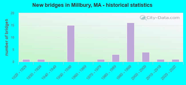
- New bridges - historical statistics
- 11920-1929
- 11930-1939
- 151950-1959
- 11970-1979
- 31980-1989
- 161990-1999
- 42000-2009
- 12010-2019
- 12020-2022

- Reconstructed bridges - Historical Statistics
- 11970-1979
- 71980-1989
- 01990-1999
- 12000-2009


- Bridge Condition - Deck
- 18.2%Very good
- 30.3%Good
- 39.4%Satisfactory
- 9.1%Fair
- 3.0%Poor

- Bridge Condition - Superstructure
- 22.9%Very good
- 34.3%Good
- 31.4%Satisfactory
- 11.4%Fair

- Bridge Condition - Substructure
- 5.7%Very good
- 54.3%Good
- 31.4%Satisfactory
- 8.6%Fair

- Bridge Condition - Channel
- 18.2%Very good
- 54.5%Good
- 4.5%Satisfactory
- 9.1%Fair
- 9.1%Poor
- 4.5%Serious

- Bridge Condition - Culverts
- 25.0%Satisfactory
- 50.0%Fair
- 25.0%Poor
Find on map >> Show street view
Structure Number: M22003AW4MUNNBI, Location: JUST N OF RTE 122A (Lat: 42.192739, Lng: -71.751817), Route carried "on" structure: City street , Year Built: 2004, Status: Open, Structure Length: 2.56m (8.40ft), Average Daily Traffic: 3,295 (year 2017), Truck Traffic: 3%, Average Future Daily Traffic: 6,791 (year 2031), Design Load: HS 20, Features Intersected: WATER BLACKSTONE RIVER, Facility Carried by Structure: HWY RIVERLIN ST
Minimum Vertical Clearance: 30+ m (98+ ft), Kilometerpoint: 0.113, Lanes on structure: 2, Owner: Town or Township Highway Agency, Approaching Roadway Width: 7.9m (25.9ft), Skew: 1 degrees, Material/Design: Prestressed concrete, Design/Construction: Box Beam or Girders - Single/Spread, Number Of Spans In Main Unit: 1, Length of Maximum Span: 23.6m (77.4ft), Curb or Sidewalk Widths: Left: 0.0m, Right: 1.5m (4.9ft), Curb-To-Curb Width: 7.9m (25.9ft), Out-to-Out Width: 10.3m (33.8ft)
Condition: Deck: Very good, Superstructure: Very good, Substructure: Good, Channel: Good, Operating Rating: 84.8 metric tons, Method Used To Determine Operating Rating: Load Factor (LF), Inventory Rating: 51.5 metric tons, Method Used To Determine Inventory Rating: Load Factor (LF), Structural Evaluation: Better than present minimum criteria, Deck Geometry: High priority of corrective action, Waterway Adequacy: Equal to present desirable criteria, Approach Roadway Alignment: Equal to present desirable criteria, Length Of Structure Improvement: 2.60m (8.53ft), Designated Inspection Frequency: Every 24 months, Inspection Date: November 2020, Bridge Improvement Cost: $1,349,000, Roadway Improvement Cost: $135,000, Total Project Cost: $2,024,000 ( Estimate for 2022), Deck Structure Type: Concrete Cast-file-Place, Wearing Surface/Protective System: Wearing Surface: Bituminous, Membrane: Built-up, Deck Protection: Epoxy Coated Reinforcing
Find on map >> Show street view
Structure Number: M220055X3DOTNBI, Location: .6 MI EAST OF ST 146 (Lat: 42.192628, Lng: -71.754281), Route carried "on" structure: Alternate State highway 122A, Year Built: 2011, Status: Open, Structure Length: 2.05m (6.73ft), Average Daily Traffic: 7,334 (year 2011), Truck Traffic: 16%, Design Load: HS 25 or greater, Features Intersected: WATER BLACKSTONE RIVER, Facility Carried by Structure: ST122 A
Minimum Vertical Clearance: 30+ m (98+ ft), Kilometerpoint: 7.084, Lanes on structure: 2, Owner: State Highway Agency, Approaching Roadway Width: 10.0m (32.8ft), Skew: 1 degrees, Material/Design: Prestressed concrete, Design/Construction: Box Beam or Girders - Single/Spread, Number Of Spans In Main Unit: 1, Length of Maximum Span: 19.5m (64.0ft), Curb or Sidewalk Widths: Left: 1.8m (5.9ft), Right: 1.8m (5.9ft), Curb-To-Curb Width: 10.0m (32.8ft), Out-to-Out Width: 14.5m (47.6ft)
Condition: Deck: Very good, Superstructure: Very good, Substructure: Very good, Channel: Fair, Operating Rating: 74.8 metric tons, Method Used To Determine Operating Rating: Load Factor (LF), Inventory Rating: 50.9 metric tons, Method Used To Determine Inventory Rating: Load Factor (LF), Structural Evaluation: Equal to present desirable criteria, Deck Geometry: Meets minimum limits, Waterway Adequacy: Better than present minimum criteria, Approach Roadway Alignment: Better than present minimum criteria, Length Of Structure Improvement: 2.10m (6.89ft), Designated Inspection Frequency: Every 24 months, Inspection Date: October 2020, Bridge Improvement Cost: $674,000, Roadway Improvement Cost: $68,000, Total Project Cost: $1,012,000 ( Estimate for 2022), Deck Structure Type: Concrete Cast-file-Place, Wearing Surface/Protective System: Wearing Surface: Bituminous, Membrane: Built-up, Deck Protection: Epoxy Coated Reinforcing
Find on map >> Show street view
Structure Number: M220061CNMUNNBI, Location: JUST S OF WEST MAIN ST (Lat: 42.189653, Lng: -71.759639), Route carried "on" structure: City street , Year Built: 1920, Status: Open, Structure Length: 1.37m (4.49ft), Average Daily Traffic: 4,282 (year 2018), Truck Traffic: 6%, Average Future Daily Traffic: 8,212 (year 2031), Features Intersected: WATER BLACKSTONE RIVER, Facility Carried by Structure: HWY S MAIN ST
Minimum Vertical Clearance: 30+ m (98+ ft), Kilometerpoint: 1.513, Lanes on structure: 1, Owner: Town or Township Highway Agency, Approaching Roadway Width: 6.7m (22.0ft), Skew: 2 degrees, Material/Design: Concrete, Design/Construction: Arch - Deck, Number Of Spans In Main Unit: 1, Length of Maximum Span: 13.7m (44.9ft), Curb or Sidewalk Widths: Left: 0.0m, Right: 1.7m (5.6ft), Curb-To-Curb Width: 3.3m (10.8ft), Out-to-Out Width: 8.9m (29.2ft)
Condition: Superstructure: Satisfactory, Substructure: Satisfactory, Channel: Very good, Inventory Rating: 75.7 metric tons, Method Used To Determine Inventory Rating: Load Factor (LF), Structural Evaluation: Equal to present minimum criteria, Deck Geometry: High priority of replacement, Waterway Adequacy: Meets minimum limits, Approach Roadway Alignment: Meets minimum limits, Length Of Structure Improvement: 2.10m (6.89ft), Designated Inspection Frequency: Every 24 months, Underwater Inspection Frequency: Every 36 months, Inspection Date: April 2021, Underwater Inspection Date: Febuary 2019, Bridge Improvement Cost: $2,090,000, Roadway Improvement Cost: $210,000, Total Project Cost: $3,136,000 ( Estimate for 2022)
Find on map >> Show street view
Structure Number: M22008ATYMUNNBI, Location: @ CEMETARY ENTRANCE (Lat: 42.193697, Lng: -71.766067), Route carried "on" structure: City street , Year Built: 2003, Status: Open, Structure Length: 2.78m (9.12ft), Average Daily Traffic: 250 (year 2015), Truck Traffic: 1%, Average Future Daily Traffic: 395 (year 2032), Design Load: HS 20, Features Intersected: WATER BLACKSTONE RIVER, Facility Carried by Structure: HWY WATERS ST
Minimum Vertical Clearance: 30+ m (98+ ft), Kilometerpoint: 0.097, Lanes on structure: 2, Owner: Town or Township Highway Agency, Approaching Roadway Width: 7.5m (24.6ft), Skew: 1 degrees, Material/Design: Prestressed concrete, Design/Construction: Box Beam or Girders - Single/Spread, Number Of Spans In Main Unit: 1, Length of Maximum Span: 25.7m (84.3ft), Curb or Sidewalk Widths: Left: 0.8m (2.6ft), Right: 0.2m (0.7ft), Curb-To-Curb Width: 7.5m (24.6ft), Out-to-Out Width: 10.4m (34.1ft)
Condition: Deck: Very good, Superstructure: Very good, Substructure: Good, Channel: Good, Operating Rating: 75.1 metric tons, Method Used To Determine Operating Rating: Load Factor (LF), Inventory Rating: 45.1 metric tons, Method Used To Determine Inventory Rating: Load Factor (LF), Structural Evaluation: Better than present minimum criteria, Deck Geometry: Somewhat better than minimum adequacy, Waterway Adequacy: Equal to present desirable criteria, Approach Roadway Alignment: Equal to present desirable criteria, Length Of Structure Improvement: 2.80m (9.19ft), Designated Inspection Frequency: Every 24 months, Inspection Date: July 2021, Bridge Improvement Cost: $924,000, Roadway Improvement Cost: $93,000, Total Project Cost: $1,387,000 ( Estimate for 2022), Deck Structure Type: Concrete Cast-file-Place, Wearing Surface/Protective System: Wearing Surface: Bituminous, Membrane: Built-up, Deck Protection: Epoxy Coated Reinforcing
Find on map >> Show street view
Structure Number: M22011229DOT634, Location: .1 MI.E. OF ST.RTE 146 (Lat: 42.188842, Lng: -71.764825), Route carried "on" structure: City street , Year Built: 1982, Status: Open, Structure Length: 6.36m (20.87ft), Average Daily Traffic: 8,224 (year 2020), Truck Traffic: 10%, Average Future Daily Traffic: 21,478 (year 2032), Design Load: HS 20, Features Intersected: COMB BLKSTNE RIV & PWRR, Facility Carried by Structure: HWY ELM ST
Minimum Vertical Clearance: 30+ m (98+ ft), Kilometerpoint: 0.000, Lanes on structure: 2, Owner: State Highway Agency, Approaching Roadway Width: 12.2m (40.0ft), Skew: 1 degrees, Material/Design: Steel, Design/Construction: Stringer/Multi-beam, Number Of Spans In Main Unit: 3, Length of Maximum Span: 30.0m (98.4ft), Curb or Sidewalk Widths: Left: 1.5m (4.9ft), Right: 1.5m (4.9ft), Curb-To-Curb Width: 12.2m (40.0ft), Out-to-Out Width: 16.0m (52.5ft)
Condition: Deck: Fair, Superstructure: Fair, Substructure: Good, Channel: Good, Operating Rating: 67.7 metric tons, Method Used To Determine Operating Rating: Load Factor (LF), Inventory Rating: 40.5 metric tons, Method Used To Determine Inventory Rating: Load Factor (LF), Structural Evaluation: Somewhat better than minimum adequacy, Deck Geometry: Somewhat better than minimum adequacy, Underclear: High priority of corrective action, Waterway Adequacy: Equal to present desirable criteria, Approach Roadway Alignment: Equal to present desirable criteria, Length Of Structure Improvement: 6.40m (21.00ft), Designated Inspection Frequency: Every 24 months, Inspection Date: August 2021, Bridge Improvement Cost: $4,043,000, Roadway Improvement Cost: $405,000, Total Project Cost: $6,065,000 ( Estimate for 2022), Deck Structure Type: Concrete Cast-file-Place, Wearing Surface/Protective System: Wearing Surface: Bituminous, Membrane: Built-up
Find on map >> Show street view
Structure Number: M220191MGDOTNBI, Location: .3 MILES SOUTH OF ST 122A (Lat: 42.199125, Lng: -71.774611), Route carried "on" structure: State highway 146, Year Built: 1981, Status: Open, Structure Length: 5.15m (16.90ft), Average Daily Traffic: 23,500 (year 2015), Truck Traffic: 20%, Average Future Daily Traffic: 37,114 (year 2032), Design Load: HS 20, Features Intersected: RR PWRR
Minimum Vertical Clearance: 30+ m (98+ ft), Kilometerpoint: 27.358, Lanes on structure: 4, Base Highway Network: Yes, Owner: State Highway Agency, Approaching Roadway Width: 27.4m (89.9ft), Skew: 27 degrees, Material/Design: Steel, Design/Construction: Stringer/Multi-beam, Number Of Spans In Main Unit: 1, Length of Maximum Span: 46.6m (152.9ft), Curb or Sidewalk Widths: Left: 1.8m (5.9ft), Right: 0.0m, Curb-To-Curb Width: 25.0m (82.0ft), Out-to-Out Width: 42.7m (140.1ft)
Condition: Deck: Fair, Superstructure: Fair, Substructure: Fair, Operating Rating: 67.4 metric tons, Method Used To Determine Operating Rating: Load Factor (LF), Inventory Rating: 40.5 metric tons, Method Used To Determine Inventory Rating: Load Factor (LF), Structural Evaluation: Somewhat better than minimum adequacy, Deck Geometry: Superior to present desirable criteria, Underclear: High priority of corrective action, Approach Roadway Alignment: Equal to present desirable criteria, Length Of Structure Improvement: 5.20m (17.06ft), Designated Inspection Frequency: Every 24 months, Critical Feature Inspection Frequency: Every 24 months, Inspection Date: January 2021, Critical Feature Inspection Date: January 2021, Bridge Improvement Cost: $8,722,000, Roadway Improvement Cost: $873,000, Total Project Cost: $13,084,000 ( Estimate for 2022), Deck Structure Type: Concrete Cast-file-Place, Wearing Surface/Protective System: Wearing Surface: Bituminous, Membrane: Built-up
Find on map >> Show street view
Structure Number: M22020BHJDOTNBI, Location: .3MI. WST. OF MILBURY CTR (Lat: 42.187608, Lng: -71.766497), Route carried "on" structure: State highway 146, Year Built: 2020, Status: Open, Structure Length: 2.43m (7.97ft), Average Daily Traffic: 48,300 (year 2021), Truck Traffic: 15%, Design Load: HS 20, Features Intersected: HWY W MAIN ST
Minimum Vertical Clearance: 30+ m (98+ ft), Kilometerpoint: 25.990, Lanes on structure: 6, Lanes under structure: 3, Owner: State Highway Agency, Approaching Roadway Width: 26.3m (86.3ft), Skew: 30 degrees, Material/Design: Steel, Design/Construction: Stringer/Multi-beam, Number Of Spans In Main Unit: 1, Length of Maximum Span: 22.6m (74.1ft), Curb-To-Curb Width: 26.3m (86.3ft), Out-to-Out Width: 28.0m (91.9ft)
Condition: Deck: Very good, Superstructure: Very good, Substructure: Very good, Operating Rating: 44.1 metric tons, Method Used To Determine Operating Rating: No rating analysis performed, Inventory Rating: 32.4 metric tons, Method Used To Determine Inventory Rating: No rating analysis performed, Structural Evaluation: Equal to present desirable criteria, Deck Geometry: Equal to present minimum criteria, Underclear: Meets minimum limits, Approach Roadway Alignment: Equal to present desirable criteria, Designated Inspection Frequency: Every 24 months, Inspection Date: January 2021, Deck Structure Type: Concrete Precast Panels, Wearing Surface/Protective System: Wearing Surface: Bituminous, Membrane: Built-up, Deck Protection: Epoxy Coated Reinforcing
Find on map >> Show street view
Structure Number: M220211MEDOTNBI, Location: .1 MI S OF W MAIN ST. (Lat: 42.184714, Lng: -71.763347), Route carried "on" structure: State highway 146, Year Built: 1936, Status: Open, Structure Length: 0.61m (2.00ft), Average Daily Traffic: 35,351 (year 2018), Truck Traffic: 6%, Average Future Daily Traffic: 71,068 (year 2032), Design Load: H 20, Features Intersected: WATER SINGLETARY BROOK
Minimum Vertical Clearance: 30+ m (98+ ft), Kilometerpoint: 0.000, Lanes on structure: 6, Base Highway Network: Yes, Owner: State Highway Agency, Approaching Roadway Width: 18.6m (61.0ft), Skew: 30 degrees, Material/Design: Concrete, Design/Construction: Arch - Deck, Number Of Spans In Main Unit: 1, Length of Maximum Span: 6.1m (20.0ft), Curb-To-Curb Width: 18.6m (61.0ft), Out-to-Out Width: 29.6m (97.1ft)
Condition: Superstructure: Fair, Substructure: Fair, Channel: Fair, Inventory Rating: 66.0 metric tons, Method Used To Determine Inventory Rating: Load Factor (LF), Structural Evaluation: Somewhat better than minimum adequacy, Deck Geometry: High priority of replacement, Waterway Adequacy: Better than present minimum criteria, Approach Roadway Alignment: Better than present minimum criteria, Length Of Structure Improvement: 0.70m (2.30ft), Designated Inspection Frequency: Every 24 months, Inspection Date: August 2021, Bridge Improvement Cost: $814,000, Roadway Improvement Cost: $82,000, Total Project Cost: $1,222,000 ( Estimate for 2022)
Find on map >> Show street view
Structure Number: M220271CPMUNNBI, Location: .1 MI S OF I- 90 (Lat: 42.205308, Lng: -71.787717), Route carried "on" structure: City street , Year Built: 1957, Year Reconstructed: 2012, Status: Open, Structure Length: 2.17m (7.12ft), Average Daily Traffic: 5,977 (year 2019), Truck Traffic: 8%, Average Future Daily Traffic: 18,004 (year 2032), Design Load: HS 20, Features Intersected: WATER DIVERSON CHANNEL, Facility Carried by Structure: HWY GREENWOOD ST
Minimum Vertical Clearance: 30+ m (98+ ft), Kilometerpoint: 2.350, Lanes on structure: 2, Owner: Town or Township Highway Agency, Approaching Roadway Width: 9.1m (29.9ft), Skew: 3 degrees, Material/Design: Prestressed concrete, Design/Construction: Stringer/Multi-beam, Number Of Spans In Main Unit: 1, Length of Maximum Span: 20.0m (65.6ft), Curb or Sidewalk Widths: Left: 1.5m (4.9ft), Right: 0.3m (1.0ft), Curb-To-Curb Width: 9.1m (29.9ft), Out-to-Out Width: 11.8m (38.7ft)
Condition: Deck: Good, Superstructure: Satisfactory, Substructure: Satisfactory, Channel: Good, Operating Rating: 63.9 metric tons, Method Used To Determine Operating Rating: Load Factor (LF), Inventory Rating: 41.2 metric tons, Method Used To Determine Inventory Rating: Load Factor (LF), Structural Evaluation: Equal to present minimum criteria, Deck Geometry: High priority of corrective action, Waterway Adequacy: Superior to present desirable criteria, Approach Roadway Alignment: Better than present minimum criteria, Length Of Structure Improvement: 2.20m (7.22ft), Designated Inspection Frequency: Every 24 months, Inspection Date: October 2020, Bridge Improvement Cost: $892,000, Roadway Improvement Cost: $90,000, Total Project Cost: $1,339,000 ( Estimate for 2022), Deck Structure Type: Concrete Cast-file-Place, Wearing Surface/Protective System: Wearing Surface: Monolithic Concrete, Deck Protection: Epoxy Coated Reinforcing
Find on map >> Show street view
Structure Number: M220281GMMUNNBI, Location: .1 MI EAST OF RIVERLIN RD (Lat: 42.192956, Lng: -71.750253), Route carried "on" structure: City street , Year Built: 1983, Status: Open, Structure Length: 0.67m (2.20ft), Average Daily Traffic: 6,826 (year 2017), Truck Traffic: 5%, Average Future Daily Traffic: 6,365 (year 2031), Design Load: HS 20, Features Intersected: WATER DOROTHY BROOK, Facility Carried by Structure: HWY GRAFTON ST
Minimum Vertical Clearance: 30+ m (98+ ft), Kilometerpoint: 0.161, Lanes on structure: 2, Owner: Town or Township Highway Agency, Approaching Roadway Width: 6.7m (22.0ft), Material/Design: Concrete, Design/Construction: Culvert, Number Of Spans In Main Unit: 2, Length of Maximum Span: 3.0m (9.8ft), Curb or Sidewalk Widths: Left: 1.5m (4.9ft), Right: 1.5m (4.9ft), Curb-To-Curb Width: 6.7m (22.0ft), Out-to-Out Width: 10.1m (33.1ft)
Condition: Channel: Good, Culverts: Fair, Operating Rating: 91.5 metric tons, Method Used To Determine Operating Rating: Allowable Stress (AS), Inventory Rating: 58.5 metric tons, Method Used To Determine Inventory Rating: Allowable Stress (AS), Structural Evaluation: Somewhat better than minimum adequacy, Deck Geometry: High priority of replacement, Waterway Adequacy: Equal to present desirable criteria, Approach Roadway Alignment: Equal to present desirable criteria, Length Of Structure Improvement: 0.70m (2.30ft), Designated Inspection Frequency: Every 24 months, Inspection Date: June 2020, Bridge Improvement Cost: $184,000, Roadway Improvement Cost: $19,000, Total Project Cost: $277,000 ( Estimate for 2022)
Find on map >> Show street view
Structure Number: M220308RTDOTNBI, Location: .2 MI W. ROUTE 146 (Lat: 42.208981, Lng: -71.783428), Route carried "on" structure: Interstate 90, Year Built: 1997, Status: Open, Structure Length: 8.01m (26.28ft), Average Daily Traffic: 91,703 (year 2015), Truck Traffic: 15%, Average Future Daily Traffic: 142,137 (year 2031), Design Load: HS 20, Features Intersected: COMB I-90RMP-CANAL-PWRR
Minimum Vertical Clearance: 30+ m (98+ ft), Kilometerpoint: 151.105, Lanes on structure: 9, Lanes under structure: 4, Base Highway Network: Yes, Toll: On toll road, Owner: State Highway Agency, Approaching Roadway Width: 43.7m (143.4ft), Skew: 31 degrees, Material/Design: Steel continuous, Design/Construction: Stringer/Multi-beam, Number Of Spans In Main Unit: 3, Length of Maximum Span: 29.5m (96.8ft), Curb-To-Curb Width: 43.7m (143.4ft), Out-to-Out Width: 44.4m (145.7ft)
Condition: Deck: Satisfactory, Superstructure: Satisfactory, Substructure: Satisfactory, Channel: Good, Operating Rating: 74.1 metric tons, Method Used To Determine Operating Rating: Load Factor (LF), Inventory Rating: 44.3 metric tons, Method Used To Determine Inventory Rating: Load Factor (LF), Structural Evaluation: Equal to present minimum criteria, Deck Geometry: Superior to present desirable criteria, Underclear: Equal to present minimum criteria, Approach Roadway Alignment: Equal to present desirable criteria, Length Of Structure Improvement: 8.10m (26.57ft), Designated Inspection Frequency: Every 24 months, Inspection Date: June 2020, Bridge Improvement Cost: $2,826,000, Roadway Improvement Cost: $283,000, Total Project Cost: $4,240,000 ( Estimate for 2022), Deck Structure Type: Concrete Cast-file-Place, Wearing Surface/Protective System: Wearing Surface: Bituminous, Membrane: Built-up, Deck Protection: Epoxy Coated Reinforcing
Find on map >> Show street view
Structure Number: M220314LWDOTNBI, Location: .1 MI W OF ST-146 K13A (Lat: 42.209500, Lng: -71.782500), Route carried "on" structure: Interstate 90, Year Built: 1957, Status: Open, Structure Length: 2.74m (8.99ft), Average Daily Traffic: 97,547 (year 2018), Truck Traffic: 7%, Average Future Daily Traffic: 142,137 (year 2032), Design Load: HS 20, Features Intersected: WATER BLACKSTONE RIVER
Minimum Vertical Clearance: 30+ m (98+ ft), Kilometerpoint: 151.194, Lanes on structure: 9, Base Highway Network: Yes, Toll: On toll road, Owner: State Highway Agency, Approaching Roadway Width: 30.5m (100.1ft), Skew: 32 degrees, Material/Design: Concrete continuous, Design/Construction: Culvert, Number Of Spans In Main Unit: 4, Length of Maximum Span: 5.5m (18.0ft)
Condition: Channel: Serious, Culverts: Satisfactory, Structural Evaluation: Equal to present minimum criteria, Waterway Adequacy: Better than present minimum criteria, Approach Roadway Alignment: Better than present minimum criteria, Length Of Structure Improvement: 1.10m (3.61ft), Designated Inspection Frequency: Every 24 months, Inspection Date: July 2021, Bridge Improvement Cost: $2,635,000, Roadway Improvement Cost: $264,000, Total Project Cost: $3,953,000 ( Estimate for 2022)
Find on map >> Show street view
Structure Number: M220324LMDOTNBI, Location: .25 MI W OF RIVERLIN ST (Lat: 42.222639, Lng: -71.735108), Route carried "on" structure: Interstate 90, Year Built: 1957, Year Reconstructed: 1988, Status: Open, Structure Length: 1.19m (3.90ft), Average Daily Traffic: 49,905 (year 2019), Truck Traffic: 12%, Average Future Daily Traffic: 78,965 (year 2032), Design Load: HS 20, Features Intersected: RR ABANDONED PWRR
Minimum Vertical Clearance: 30+ m (98+ ft), Kilometerpoint: 155.458, Lanes on structure: 3, Base Highway Network: Yes, Toll: On toll road, Owner: State Highway Agency, Approaching Roadway Width: 16.3m (53.5ft), Material/Design: Steel, Design/Construction: Stringer/Multi-beam, Number Of Spans In Main Unit: 1, Length of Maximum Span: 10.4m (34.1ft), Curb-To-Curb Width: 16.3m (53.5ft), Out-to-Out Width: 17.2m (56.4ft)
Condition: Deck: Good, Superstructure: Satisfactory, Substructure: Satisfactory, Operating Rating: 60.6 metric tons, Method Used To Determine Operating Rating: Load Factor (LF), Inventory Rating: 36.3 metric tons, Method Used To Determine Inventory Rating: Load Factor (LF), Structural Evaluation: Equal to present minimum criteria, Deck Geometry: Equal to present minimum criteria, Approach Roadway Alignment: Equal to present desirable criteria, Length Of Structure Improvement: 1.20m (3.94ft), Designated Inspection Frequency: Every 24 months, Inspection Date: Febuary 2021, Bridge Improvement Cost: $238,000, Roadway Improvement Cost: $24,000, Total Project Cost: $358,000 ( Estimate for 2022), Deck Structure Type: Concrete Cast-file-Place, Wearing Surface/Protective System: Wearing Surface: Bituminous, Membrane: Built-up, Deck Protection: Epoxy Coated Reinforcing
Find on map >> Show street view
Structure Number: M220324LNDOTNBI, Location: I-90 MM 96.6 (Lat: 42.222847, Lng: -71.735072), Route carried "on" structure: Interstate 90, Year Built: 1957, Year Reconstructed: 1988, Status: Open, Structure Length: 1.19m (3.90ft), Average Daily Traffic: 50,236 (year 2019), Truck Traffic: 12%, Average Future Daily Traffic: 78,965 (year 2032), Design Load: HS 20, Features Intersected: RR ABANDONED PWRR
Minimum Vertical Clearance: 30+ m (98+ ft), Kilometerpoint: 155.458, Lanes on structure: 4, Base Highway Network: Yes, Toll: On toll road, Owner: State Highway Agency, Approaching Roadway Width: 19.9m (65.3ft), Skew: 10 degrees, Material/Design: Steel, Design/Construction: Stringer/Multi-beam, Number Of Spans In Main Unit: 1, Length of Maximum Span: 10.4m (34.1ft), Curb-To-Curb Width: 19.9m (65.3ft), Out-to-Out Width: 20.9m (68.6ft)
Condition: Deck: Satisfactory, Superstructure: Satisfactory, Substructure: Fair, Operating Rating: 59.5 metric tons, Method Used To Determine Operating Rating: Load Factor (LF), Inventory Rating: 35.6 metric tons, Method Used To Determine Inventory Rating: Load Factor (LF), Structural Evaluation: Somewhat better than minimum adequacy, Deck Geometry: Equal to present minimum criteria, Approach Roadway Alignment: Equal to present desirable criteria, Length Of Structure Improvement: 1.20m (3.94ft), Designated Inspection Frequency: Every 24 months, Inspection Date: Febuary 2021, Bridge Improvement Cost: $986,000, Roadway Improvement Cost: $99,000, Total Project Cost: $1,480,000 ( Estimate for 2022), Deck Structure Type: Concrete Cast-file-Place, Wearing Surface/Protective System: Wearing Surface: Bituminous, Membrane: Built-up, Deck Protection: Epoxy Coated Reinforcing
Find on map >> Show street view
Structure Number: M220338RUDOTNBI, Location: I-90 MM 93.57 (Lat: 42.206956, Lng: -71.788756), Route carried "on" structure: City street , Year Built: 1997, Status: Open, Structure Length: 8.40m (27.56ft), Average Daily Traffic: 4,900 (year 2004), Truck Traffic: 5%, Average Future Daily Traffic: 2,053 (year 2031), Design Load: HS 20, Features Intersected: I 90, Facility Carried by Structure: HWY GREENWOOD AV
Minimum Vertical Clearance: 99.00m (324.80ft), Kilometerpoint: 4.000, Lanes on structure: 2, Lanes under structure: 8, Toll: On toll road, Owner: State Highway Agency, Approaching Roadway Width: 9.1m (29.9ft), Material/Design: Steel continuous, Design/Construction: Stringer/Multi-beam, Number Of Spans In Main Unit: 3, Length of Maximum Span: 31.6m (103.7ft), Curb or Sidewalk Widths: Left: 1.8m (5.9ft), Right: 0.0m, Curb-To-Curb Width: 9.1m (29.9ft), Out-to-Out Width: 11.8m (38.7ft)
Condition: Deck: Satisfactory, Superstructure: Good, Substructure: Good, Operating Rating: 85.2 metric tons, Method Used To Determine Operating Rating: Load Factor (LF), Inventory Rating: 51.0 metric tons, Method Used To Determine Inventory Rating: Load Factor (LF), Structural Evaluation: Better than present minimum criteria, Deck Geometry: Meets minimum limits, Approach Roadway Alignment: Better than present minimum criteria, Length Of Structure Improvement: 8.50m (27.89ft), Designated Inspection Frequency: Every 24 months, Inspection Date: August 2020, Bridge Improvement Cost: $3,415,000, Roadway Improvement Cost: $342,000, Total Project Cost: $5,123,000 ( Estimate for 2022), Deck Structure Type: Concrete Cast-file-Place, Wearing Surface/Protective System: Wearing Surface: Bituminous, Membrane: Built-up, Deck Protection: Epoxy Coated Reinforcing
Find on map >> Show street view
Structure Number: M220344LXDOTNBI, Location: .3 MI S OF US-20 (Lat: 42.210006, Lng: -71.781281), Route carried "on" structure: Interstate 90, Year Built: 1997, Status: Open, Structure Length: 9.51m (31.20ft), Average Daily Traffic: 53,498 (year 2019), Truck Traffic: 16%, Average Future Daily Traffic: 90,085 (year 2032), Design Load: HS 20+Mod, Features Intersected: ST146
Minimum Vertical Clearance: 30+ m (98+ ft), Kilometerpoint: 151.274, Lanes on structure: 5, Lanes under structure: 6, Base Highway Network: Yes, Toll: On toll road, Owner: State Highway Agency, Approaching Roadway Width: 23.5m (77.1ft), Skew: 1 degrees, Material/Design: Steel continuous, Design/Construction: Stringer/Multi-beam, Number Of Spans In Main Unit: 2, Length of Maximum Span: 47.5m (155.8ft), Curb-To-Curb Width: 23.5m (77.1ft), Out-to-Out Width: 24.6m (80.7ft)
Condition: Deck: Good, Superstructure: Good, Substructure: Good, Operating Rating: 64.4 metric tons, Method Used To Determine Operating Rating: Load Factor (LF), Inventory Rating: 38.6 metric tons, Method Used To Determine Inventory Rating: Load Factor (LF), Structural Evaluation: Better than present minimum criteria, Deck Geometry: Equal to present minimum criteria, Underclear: High priority of corrective action, Approach Roadway Alignment: Equal to present desirable criteria, Length Of Structure Improvement: 9.60m (31.50ft), Designated Inspection Frequency: Every 24 months, Inspection Date: Febuary 2021, Bridge Improvement Cost: $2,082,000, Roadway Improvement Cost: $209,000, Total Project Cost: $3,124,000 ( Estimate for 2022), Deck Structure Type: Concrete Cast-file-Place, Wearing Surface/Protective System: Wearing Surface: Bituminous, Membrane: Built-up, Deck Protection: Epoxy Coated Reinforcing
Find on map >> Show street view
Structure Number: M220344LYDOTNBI, Location: .3 MI S OF US-20 (Lat: 42.210142, Lng: -71.781494), Route carried "on" structure: Interstate 90, Year Built: 1997, Status: Open, Structure Length: 9.56m (31.36ft), Average Daily Traffic: 45,851 (year 2015), Truck Traffic: 12%, Average Future Daily Traffic: 91,599 (year 2032), Design Load: HS 20+Mod, Features Intersected: ST146
Minimum Vertical Clearance: 30+ m (98+ ft), Kilometerpoint: 151.274, Lanes on structure: 3, Lanes under structure: 6, Base Highway Network: Yes, Toll: On toll road, Owner: State Highway Agency, Approaching Roadway Width: 18.6m (61.0ft), Skew: 1 degrees, Material/Design: Steel continuous, Design/Construction: Stringer/Multi-beam, Number Of Spans In Main Unit: 2, Length of Maximum Span: 48.3m (158.5ft), Curb-To-Curb Width: 18.6m (61.0ft), Out-to-Out Width: 19.7m (64.6ft)
Condition: Deck: Good, Superstructure: Good, Substructure: Good, Operating Rating: 64.2 metric tons, Method Used To Determine Operating Rating: Load Factor (LF), Inventory Rating: 38.4 metric tons, Method Used To Determine Inventory Rating: Load Factor (LF), Structural Evaluation: Better than present minimum criteria, Deck Geometry: Superior to present desirable criteria, Underclear: High priority of corrective action, Approach Roadway Alignment: Equal to present desirable criteria, Length Of Structure Improvement: 9.60m (31.50ft), Designated Inspection Frequency: Every 24 months, Inspection Date: Febuary 2021, Bridge Improvement Cost: $745,000, Roadway Improvement Cost: $75,000, Total Project Cost: $1,118,000 ( Estimate for 2022), Deck Structure Type: Concrete Cast-file-Place, Wearing Surface/Protective System: Wearing Surface: Bituminous, Membrane: Built-up, Deck Protection: Epoxy Coated Reinforcing
Find on map >> Show street view
Structure Number: M220354LVDOTNBI, Location: .4 MI E OF 146 (Lat: 42.212897, Lng: -71.776072), Route carried "on" structure: City street , Year Built: 1957, Year Reconstructed: 1994, Status: Open, Structure Length: 10.55m (34.61ft), Average Daily Traffic: 1,859 (year 2020), Truck Traffic: 7%, Average Future Daily Traffic: 2,843 (year 2032), Design Load: HS 20, Features Intersected: I 90, Facility Carried by Structure: HWY PARK HLL AVE
Minimum Vertical Clearance: 30+ m (98+ ft), Kilometerpoint: 151.757, Lanes on structure: 2, Lanes under structure: 7, Owner: State Highway Agency, Approaching Roadway Width: 7.3m (24.0ft), Material/Design: Steel continuous, Design/Construction: Stringer/Multi-beam, Number Of Spans In Main Unit: 2, Number Of Approach Spans: 3, Length of Maximum Span: 27.4m (89.9ft), Curb or Sidewalk Widths: Left: 1.8m (5.9ft), Right: 0.8m (2.6ft), Curb-To-Curb Width: 7.3m (24.0ft), Out-to-Out Width: 10.8m (35.4ft)
Condition: Deck: Satisfactory, Superstructure: Satisfactory, Substructure: Satisfactory, Operating Rating: 58.3 metric tons, Method Used To Determine Operating Rating: Load Factor (LF), Inventory Rating: 34.9 metric tons, Method Used To Determine Inventory Rating: Load Factor (LF), Structural Evaluation: Equal to present minimum criteria, Deck Geometry: Meets minimum limits, Underclear: High priority of corrective action, Approach Roadway Alignment: Equal to present desirable criteria, Length Of Structure Improvement: 10.60m (34.78ft), Designated Inspection Frequency: Every 24 months, Inspection Date: June 2021, Bridge Improvement Cost: $6,097,000, Roadway Improvement Cost: $610,000, Total Project Cost: $9,146,000 ( Estimate for 2022), Deck Structure Type: Concrete Cast-file-Place, Wearing Surface/Protective System: Wearing Surface: Bituminous, Deck Protection: Epoxy Coated Reinforcing
Find on map >> Show street view
Structure Number: M220364LTDOTNBI, Location: I 90 MM 95.3 (Lat: 42.220108, Lng: -71.759464), Route carried "on" structure: Interstate 90, Year Built: 1957, Year Reconstructed: 1986, Status: Open, Structure Length: 1.52m (4.99ft), Average Daily Traffic: 46,081 (year 2016), Truck Traffic: 15%, Average Future Daily Traffic: 78,965 (year 2033), Design Load: HS 20, Features Intersected: HWY MILLBURY AVE
Minimum Vertical Clearance: 30+ m (98+ ft), Kilometerpoint: 153.366, Lanes on structure: 3, Lanes under structure: 2, Base Highway Network: Yes, Toll: On toll road, Owner: State Highway Agency, Approaching Roadway Width: 16.0m (52.5ft), Material/Design: Steel, Design/Construction: Stringer/Multi-beam, Number Of Spans In Main Unit: 1, Length of Maximum Span: 13.7m (44.9ft), Curb-To-Curb Width: 16.0m (52.5ft), Out-to-Out Width: 17.2m (56.4ft)
Condition: Deck: Satisfactory, Superstructure: Satisfactory, Substructure: Satisfactory, Operating Rating: 59.4 metric tons, Method Used To Determine Operating Rating: Load Factor (LF), Inventory Rating: 35.6 metric tons, Method Used To Determine Inventory Rating: Load Factor (LF), Structural Evaluation: Equal to present minimum criteria, Deck Geometry: Equal to present minimum criteria, Underclear: High priority of corrective action, Approach Roadway Alignment: Equal to present desirable criteria, Length Of Structure Improvement: 1.60m (5.25ft), Designated Inspection Frequency: Every 24 months, Inspection Date: Febuary 2022, Bridge Improvement Cost: $363,000, Roadway Improvement Cost: $37,000, Total Project Cost: $545,000 ( Estimate for 2022), Deck Structure Type: Concrete Cast-file-Place, Wearing Surface/Protective System: Wearing Surface: Bituminous, Membrane: Built-up, Deck Protection: Epoxy Coated Reinforcing
Find on map >> Show street view
Structure Number: M220364LUDOTNBI, Location: I-90 MM 95.3 (Lat: 42.220206, Lng: -71.759561), Route carried "on" structure: Interstate 90, Year Built: 1957, Year Reconstructed: 1986, Status: Open, Structure Length: 1.52m (4.99ft), Average Daily Traffic: 46,081 (year 2016), Truck Traffic: 15%, Average Future Daily Traffic: 78,965 (year 2033), Design Load: HS 20, Features Intersected: HWY MILLBURY AVE
Minimum Vertical Clearance: 30+ m (98+ ft), Kilometerpoint: 153.366, Lanes on structure: 3, Lanes under structure: 2, Base Highway Network: Yes, Toll: On toll road, Owner: State Highway Agency, Approaching Roadway Width: 16.5m (54.1ft), Material/Design: Steel, Design/Construction: Stringer/Multi-beam, Number Of Spans In Main Unit: 1, Length of Maximum Span: 13.7m (44.9ft), Curb-To-Curb Width: 16.5m (54.1ft), Out-to-Out Width: 17.2m (56.4ft)
Condition: Deck: Satisfactory, Superstructure: Satisfactory, Substructure: Satisfactory, Operating Rating: 67.3 metric tons, Method Used To Determine Operating Rating: Load Factor (LF), Inventory Rating: 40.3 metric tons, Method Used To Determine Inventory Rating: Load Factor (LF), Structural Evaluation: Equal to present minimum criteria, Deck Geometry: Equal to present minimum criteria, Underclear: High priority of corrective action, Approach Roadway Alignment: Equal to present desirable criteria, Length Of Structure Improvement: 1.60m (5.25ft), Designated Inspection Frequency: Every 24 months, Inspection Date: Febuary 2022, Bridge Improvement Cost: $287,000, Roadway Improvement Cost: $29,000, Total Project Cost: $431,000 ( Estimate for 2022), Deck Structure Type: Concrete Cast-file-Place, Wearing Surface/Protective System: Wearing Surface: Bituminous, Membrane: Preformed Fabric, Deck Protection: Epoxy Coated Reinforcing
Find on map >> Show street view
Structure Number: M220374LQDOTNBI, Location: I-90 MM 95.9 (Lat: 42.222089, Lng: -71.748547), Route carried "on" structure: Interstate 90, Year Built: 1957, Year Reconstructed: 1986, Status: Open, Structure Length: 1.49m (4.89ft), Average Daily Traffic: 46,910 (year 2017), Truck Traffic: 12%, Average Future Daily Traffic: 90,085 (year 2031), Design Load: HS 20, Features Intersected: HWY WHEELOCK AVE
Minimum Vertical Clearance: 30+ m (98+ ft), Kilometerpoint: 154.332, Lanes on structure: 3, Lanes under structure: 2, Base Highway Network: Yes, Toll: On toll road, Owner: State Highway Agency, Approaching Roadway Width: 15.2m (49.9ft), Skew: 3 degrees, Material/Design: Steel, Design/Construction: Stringer/Multi-beam, Number Of Spans In Main Unit: 1, Length of Maximum Span: 13.2m (43.3ft), Curb-To-Curb Width: 15.2m (49.9ft), Out-to-Out Width: 17.2m (56.4ft)
Condition: Deck: Satisfactory, Superstructure: Satisfactory, Substructure: Satisfactory, Operating Rating: 65.5 metric tons, Method Used To Determine Operating Rating: Load Factor (LF), Inventory Rating: 39.2 metric tons, Method Used To Determine Inventory Rating: Load Factor (LF), Structural Evaluation: Equal to present minimum criteria, Deck Geometry: Meets minimum limits, Underclear: High priority of corrective action, Approach Roadway Alignment: Equal to present desirable criteria, Length Of Structure Improvement: 1.50m (4.92ft), Designated Inspection Frequency: Every 24 months, Inspection Date: April 2020, Bridge Improvement Cost: $453,000, Roadway Improvement Cost: $46,000, Total Project Cost: $680,000 ( Estimate for 2022), Deck Structure Type: Concrete Cast-file-Place, Wearing Surface/Protective System: Wearing Surface: Bituminous, Membrane: Built-up, Deck Protection: Epoxy Coated Reinforcing
Find on map >> Show street view
Structure Number: M220374LRDOTNBI, Location: I-90 MM 95.9 (Lat: 42.222269, Lng: -71.748431), Route carried "on" structure: Interstate 90, Year Built: 1957, Year Reconstructed: 1986, Status: Open, Structure Length: 1.49m (4.89ft), Average Daily Traffic: 46,910 (year 2018), Truck Traffic: 8%, Average Future Daily Traffic: 90,085 (year 2031), Design Load: HS 20, Features Intersected: HWY WHEELOCK AVE
Minimum Vertical Clearance: 30+ m (98+ ft), Kilometerpoint: 154.332, Lanes on structure: 3, Lanes under structure: 2, Base Highway Network: Yes, Toll: On toll road, Owner: State Highway Agency, Approaching Roadway Width: 15.2m (49.9ft), Skew: 3 degrees, Material/Design: Steel, Design/Construction: Stringer/Multi-beam, Number Of Spans In Main Unit: 1, Length of Maximum Span: 13.2m (43.3ft), Curb-To-Curb Width: 15.2m (49.9ft), Out-to-Out Width: 17.2m (56.4ft)
Condition: Deck: Fair, Superstructure: Satisfactory, Substructure: Good, Operating Rating: 72.2 metric tons, Method Used To Determine Operating Rating: Load Factor (LF), Inventory Rating: 43.2 metric tons, Method Used To Determine Inventory Rating: Load Factor (LF), Structural Evaluation: Equal to present minimum criteria, Deck Geometry: Meets minimum limits, Underclear: High priority of corrective action, Approach Roadway Alignment: Equal to present desirable criteria, Length Of Structure Improvement: 1.50m (4.92ft), Designated Inspection Frequency: Every 24 months, Inspection Date: April 2020, Bridge Improvement Cost: $1,264,000, Roadway Improvement Cost: $127,000, Total Project Cost: $1,897,000 ( Estimate for 2022), Deck Structure Type: Concrete Cast-file-Place, Wearing Surface/Protective System: Wearing Surface: Bituminous, Membrane: Built-up, Deck Protection: Epoxy Coated Reinforcing
Find on map >> Show street view
Structure Number: M220384LPDOTNBI, Location: .5 MI. S. OF ST-122 (Lat: 42.222553, Lng: -71.740225), Route carried "on" structure: Ramp Interstate 90, Year Built: 1957, Year Reconstructed: 1978, Status: Open, Structure Length: 7.47m (24.51ft), Average Daily Traffic: 7,911 (year 2017), Truck Traffic: 15%, Average Future Daily Traffic: 33,165 (year 2032), Design Load: HS 20, Features Intersected: I 90
Minimum Vertical Clearance: 99.00m (324.80ft), Kilometerpoint: 154.976, Lanes on structure: 2, Lanes under structure: 7, Base Highway Network: Yes, Toll: On toll road, Owner: State Highway Agency, Approaching Roadway Width: 13.2m (43.3ft), Skew: 20 degrees, Material/Design: Steel continuous, Design/Construction: Stringer/Multi-beam, Number Of Spans In Main Unit: 2, Number Of Approach Spans: 2, Length of Maximum Span: 23.5m (77.1ft), Curb-To-Curb Width: 13.2m (43.3ft), Out-to-Out Width: 15.8m (51.8ft)
Condition: Deck: Poor, Superstructure: Fair, Substructure: Satisfactory, Operating Rating: 56.7 metric tons, Method Used To Determine Operating Rating: Load Factor (LF), Inventory Rating: 34.0 metric tons, Method Used To Determine Inventory Rating: Load Factor (LF), Structural Evaluation: Somewhat better than minimum adequacy, Deck Geometry: Superior to present desirable criteria, Underclear: High priority of corrective action, Approach Roadway Alignment: Equal to present minimum criteria, Length Of Structure Improvement: 7.50m (24.61ft), Designated Inspection Frequency: Every 12 months, Other Special Inspection Frequency: Every 12 months, Inspection Date: October 2020, Other Special Inspection Date: October 2021, Bridge Improvement Cost: $4,655,000, Roadway Improvement Cost: $466,000, Total Project Cost: $6,983,000 ( Estimate for 2022), Deck Structure Type: Concrete Cast-file-Place, Wearing Surface/Protective System: Wearing Surface: Bituminous, Membrane: Built-up
Find on map >> Show street view
Structure Number: M220394M3DOTNBI, Location: NEAR AUBURN TOWN LINE (Lat: 42.206156, Lng: -71.797983), Route carried "on" structure: Interstate 90, Year Built: 1957, Status: Open, Structure Length: 2.06m (6.76ft), Average Daily Traffic: 89,963 (year 2017), Truck Traffic: 15%, Average Future Daily Traffic: 135,294 (year 2031), Design Load: HS 20, Features Intersected: WATER DIVERSION CHANNEL
Minimum Vertical Clearance: 30+ m (98+ ft), Kilometerpoint: 149.826, Lanes on structure: 6, Base Highway Network: Yes, Toll: On toll road, Owner: State Highway Agency, Approaching Roadway Width: 30.5m (100.1ft), Skew: 21 degrees, Material/Design: Concrete continuous, Design/Construction: Culvert, Number Of Spans In Main Unit: 3, Length of Maximum Span: 6.4m (21.0ft)
Condition: Channel: Good, Culverts: Fair, Inventory Rating: 81.0 metric tons, Method Used To Determine Inventory Rating: Load Factor (LF), Structural Evaluation: Somewhat better than minimum adequacy, Waterway Adequacy: Equal to present desirable criteria, Approach Roadway Alignment: Equal to present desirable criteria, Length Of Structure Improvement: 3.30m (10.83ft), Designated Inspection Frequency: Every 24 months, Inspection Date: April 2020, Bridge Improvement Cost: $2,540,000, Roadway Improvement Cost: $255,000, Total Project Cost: $3,811,000 ( Estimate for 2022)
Find on map >> Show street view
Structure Number: M220448HDDOTNBI, Location: .1 MI W OF ST-122A (Lat: 42.201619, Lng: -71.775842), Route carried "on" structure: State highway 146, Year Built: 1998, Status: Open, Structure Length: 3.29m (10.79ft), Average Daily Traffic: 23,762 (year 2020), Truck Traffic: 6%, Average Future Daily Traffic: 23,690 (year 2032), Design Load: HS 20, Features Intersected: WATER BLACKSTONE RIVER
Minimum Vertical Clearance: 99.00m (324.80ft), Kilometerpoint: 28.034, Lanes on structure: 2, Owner: State Highway Agency, Approaching Roadway Width: 11.9m (39.0ft), Material/Design: Prestressed concrete, Design/Construction: Stringer/Multi-beam, Number Of Spans In Main Unit: 1, Length of Maximum Span: 32.8m (107.6ft), Curb-To-Curb Width: 11.9m (39.0ft), Out-to-Out Width: 12.8m (42.0ft)
Condition: Deck: Good, Superstructure: Very good, Substructure: Good, Channel: Good, Operating Rating: 91.5 metric tons, Method Used To Determine Operating Rating: Load Factor (LF), Inventory Rating: 54.8 metric tons, Method Used To Determine Inventory Rating: Load Factor (LF), Structural Evaluation: Better than present minimum criteria, Deck Geometry: High priority of replacement, Waterway Adequacy: Superior to present desirable criteria, Approach Roadway Alignment: Equal to present desirable criteria, Length Of Structure Improvement: 4.20m (13.78ft), Designated Inspection Frequency: Every 24 months, Inspection Date: October 2021, Bridge Improvement Cost: $3,014,000, Roadway Improvement Cost: $302,000, Total Project Cost: $4,522,000 ( Estimate for 2022), Deck Structure Type: Concrete Cast-file-Place, Wearing Surface/Protective System: Wearing Surface: Latex Concrete, Deck Protection: Epoxy Coated Reinforcing
Find on map >> Show street view
Structure Number: M220448HEDOTNBI, Location: .1 MI. W. OF ST 122A (Lat: 42.201636, Lng: -71.775692), Route carried "on" structure: State highway 146, Year Built: 1998, Status: Open, Structure Length: 3.29m (10.79ft), Average Daily Traffic: 25,208 (year 2016), Truck Traffic: 6%, Average Future Daily Traffic: 23,690 (year 2032), Design Load: HS 20, Features Intersected: WATER BLACKSTONE RIVER
Minimum Vertical Clearance: 99.00m (324.80ft), Kilometerpoint: 28.034, Lanes on structure: 2, Owner: State Highway Agency, Approaching Roadway Width: 11.9m (39.0ft), Material/Design: Prestressed concrete, Design/Construction: Stringer/Multi-beam, Number Of Spans In Main Unit: 1, Length of Maximum Span: 32.8m (107.6ft), Curb-To-Curb Width: 11.9m (39.0ft), Out-to-Out Width: 12.8m (42.0ft)
Condition: Deck: Good, Superstructure: Very good, Substructure: Good, Channel: Good, Operating Rating: 91.5 metric tons, Method Used To Determine Operating Rating: Load Factor (LF), Inventory Rating: 54.8 metric tons, Method Used To Determine Inventory Rating: Load Factor (LF), Structural Evaluation: Better than present minimum criteria, Deck Geometry: High priority of replacement, Waterway Adequacy: Superior to present desirable criteria, Approach Roadway Alignment: Equal to present desirable criteria, Length Of Structure Improvement: 4.20m (13.78ft), Designated Inspection Frequency: Every 24 months, Inspection Date: October 2021, Bridge Improvement Cost: $3,014,000, Roadway Improvement Cost: $302,000, Total Project Cost: $4,522,000 ( Estimate for 2022), Deck Structure Type: Concrete Cast-file-Place, Wearing Surface/Protective System: Wearing Surface: Latex Concrete, Deck Protection: Epoxy Coated Reinforcing
Find on map >> Show street view
Structure Number: M22044AHBDOTNBI, Location: .1 MI W. OF ST. 122A (Lat: 42.201581, Lng: -71.775997), Route carried "on" structure: State highway 146, Year Built: 1998, Status: Open, Structure Length: 3.29m (10.79ft), Average Daily Traffic: 5,284 (year 2020), Truck Traffic: 7%, Average Future Daily Traffic: 15,793 (year 2032), Design Load: HS 20, Features Intersected: WATER BLACKSTONE RIVER
Minimum Vertical Clearance: 99.00m (324.80ft), Kilometerpoint: 28.034, Lanes on structure: 1, Owner: State Highway Agency, Approaching Roadway Width: 8.5m (27.9ft), Material/Design: Prestressed concrete, Design/Construction: Stringer/Multi-beam, Number Of Spans In Main Unit: 1, Length of Maximum Span: 32.8m (107.6ft), Curb-To-Curb Width: 8.5m (27.9ft), Out-to-Out Width: 9.4m (30.8ft)
Condition: Deck: Good, Superstructure: Very good, Substructure: Good, Channel: Good, Operating Rating: 91.5 metric tons, Method Used To Determine Operating Rating: Load Factor (LF), Inventory Rating: 54.8 metric tons, Method Used To Determine Inventory Rating: Load Factor (LF), Structural Evaluation: Better than present minimum criteria, Deck Geometry: High priority of replacement, Waterway Adequacy: Superior to present desirable criteria, Approach Roadway Alignment: Equal to present desirable criteria, Length Of Structure Improvement: 4.20m (13.78ft), Designated Inspection Frequency: Every 24 months, Inspection Date: October 2021, Bridge Improvement Cost: $3,146,000, Roadway Improvement Cost: $315,000, Total Project Cost: $4,720,000 ( Estimate for 2022), Deck Structure Type: Concrete Cast-file-Place, Wearing Surface/Protective System: Wearing Surface: Latex Concrete, Deck Protection: Epoxy Coated Reinforcing
Find on map >> Show street view
Structure Number: M220458G6DOTNBI, Location: .3 MI W. ROUTE 146 (Lat: 42.207342, Lng: -71.787578), Route carried "on" structure: Ramp Interstate 90, Year Built: 1997, Status: Open, Structure Length: 6.74m (22.11ft), Average Daily Traffic: 7,352 (year 2020), Truck Traffic: 7%, Average Future Daily Traffic: 39,482 (year 2032), Design Load: HS 20+Mod, Features Intersected: I 90
Minimum Vertical Clearance: 30+ m (98+ ft), Kilometerpoint: 150.727, Lanes on structure: 2, Lanes under structure: 7, Toll: On toll road, Owner: State Highway Agency, Approaching Roadway Width: 13.4m (44.0ft), Skew: 21 degrees, Material/Design: Steel continuous, Design/Construction: Stringer/Multi-beam, Number Of Spans In Main Unit: 2, Length of Maximum Span: 33.9m (111.2ft), Curb-To-Curb Width: 6.7m (22.0ft), Out-to-Out Width: 15.5m (50.9ft)
Condition: Deck: Satisfactory, Superstructure: Good, Substructure: Good, Operating Rating: 78.4 metric tons, Method Used To Determine Operating Rating: Load Factor (LF), Inventory Rating: 46.9 metric tons, Method Used To Determine Inventory Rating: Load Factor (LF), Structural Evaluation: Better than present minimum criteria, Deck Geometry: High priority of replacement, Underclear: Equal to present minimum criteria, Approach Roadway Alignment: Equal to present minimum criteria, Length Of Structure Improvement: 6.80m (22.31ft), Designated Inspection Frequency: Every 24 months, Inspection Date: June 2021, Bridge Improvement Cost: $4,296,000, Roadway Improvement Cost: $430,000, Total Project Cost: $6,445,000 ( Estimate for 2022), Deck Structure Type: Concrete Cast-file-Place, Wearing Surface/Protective System: Wearing Surface: Bituminous, Membrane: Built-up, Deck Protection: Epoxy Coated Reinforcing
Find on map >> Show street view
Structure Number: M2204687BDOTNBI, Location: .3 MI S OF WORC T/L (Lat: 42.213161, Lng: -71.783711), Route carried "on" structure: US 20, Year Built: 2005, Status: Open, Structure Length: 30.97m (101.61ft), Average Daily Traffic: 11,227 (year 2020), Truck Traffic: 6%, Average Future Daily Traffic: 37,903 (year 2032), Design Load: HS 20, Features Intersected: COMB ST146&PWRR&BLKSTN
Minimum Vertical Clearance: 30+ m (98+ ft), Kilometerpoint: 180.740, Lanes on structure: 2, Lanes under structure: 5, Toll: On toll road, Owner: State Highway Agency, Approaching Roadway Width: 12.2m (40.0ft), Skew: 3 degrees, Material/Design: Steel continuous, Design/Construction: Box Beam or Girders - Multiple, Number Of Spans In Main Unit: 5, Number Of Approach Spans: 2, Length of Maximum Span: 48.8m (160.1ft), Curb-To-Curb Width: 11.3m (37.1ft), Out-to-Out Width: 12.2m (40.0ft)
Condition: Deck: Satisfactory, Superstructure: Good, Substructure: Satisfactory, Channel: Very good, Operating Rating: 55.0 metric tons, Method Used To Determine Operating Rating: Load Factor (LF), Inventory Rating: 33.0 metric tons, Method Used To Determine Inventory Rating: Load Factor (LF), Structural Evaluation: Equal to present minimum criteria, Deck Geometry: Equal to present minimum criteria, Underclear: Equal to present minimum criteria, Waterway Adequacy: Equal to present desirable criteria, Approach Roadway Alignment: Equal to present desirable criteria, Length Of Structure Improvement: 31.00m (101.71ft), Designated Inspection Frequency: Every 24 months, Inspection Date: September 2021, Bridge Improvement Cost: $4,385,000, Roadway Improvement Cost: $439,000, Total Project Cost: $6,578,000 ( Estimate for 2022), Deck Structure Type: Concrete Cast-file-Place, Wearing Surface/Protective System: Wearing Surface: Bituminous, Membrane: Built-up, Deck Protection: Epoxy Coated Reinforcing
Find on map >> Show street view
Structure Number: M22046AMFDOTNBI, Location: .3 MI S OF WORCESTER T.L. (Lat: 42.213289, Lng: -71.783775), Route carried "on" structure: US 20, Year Built: 2005, Status: Open, Structure Length: 31.17m (102.26ft), Average Daily Traffic: 12,604 (year 2019), Truck Traffic: 4%, Average Future Daily Traffic: 38,377 (year 2032), Design Load: HS 20, Features Intersected: COMB ST146&PWRR&BLKSTN
Minimum Vertical Clearance: 12.10m (39.70ft), Kilometerpoint: 180.740, Lanes on structure: 2, Lanes under structure: 5, Owner: State Highway Agency, Approaching Roadway Width: 12.1m (39.7ft), Skew: 3 degrees, Material/Design: Steel continuous, Design/Construction: Box Beam or Girders - Multiple, Number Of Spans In Main Unit: 5, Number Of Approach Spans: 2, Length of Maximum Span: 48.8m (160.1ft), Curb-To-Curb Width: 11.3m (37.1ft), Out-to-Out Width: 12.1m (39.7ft)
Condition: Deck: Satisfactory, Superstructure: Good, Substructure: Good, Channel: Very good, Operating Rating: 54.1 metric tons, Method Used To Determine Operating Rating: Load Factor (LF), Inventory Rating: 32.4 metric tons, Method Used To Determine Inventory Rating: Load Factor (LF), Structural Evaluation: Better than present minimum criteria, Deck Geometry: High priority of replacement, Underclear: Meets minimum limits, Waterway Adequacy: Equal to present desirable criteria, Approach Roadway Alignment: Equal to present desirable criteria, Length Of Structure Improvement: 31.20m (102.36ft), Designated Inspection Frequency: Every 24 months, Inspection Date: September 2021, Bridge Improvement Cost: $22,226,000, Roadway Improvement Cost: $2,223,000, Total Project Cost: $33,340,000 ( Estimate for 2022), Deck Structure Type: Concrete Cast-file-Place, Wearing Surface/Protective System: Wearing Surface: Bituminous, Membrane: Built-up, Deck Protection: Epoxy Coated Reinforcing
Find on map >> Show street view
Structure Number: M22047AFJDOTNBI, Location: .1 MI S OF US-20 (Lat: 42.211464, Lng: -71.781922), Route carried "on" structure: Ramp State highway , Year Built: 1996, Status: Open, Structure Length: 3.99m (13.09ft), Average Daily Traffic: 24,772 (year 2018), Truck Traffic: 15%, Average Future Daily Traffic: 55,276 (year 2032), Design Load: HS 20, Features Intersected: ST146, Facility Carried by Structure: US 20 CONNECTOR
Minimum Vertical Clearance: 30+ m (98+ ft), Kilometerpoint: 0.000, Lanes on structure: 4, Lanes under structure: 5, Owner: State Highway Agency, Approaching Roadway Width: 24.4m (80.1ft), Skew: 21 degrees, Material/Design: Prestressed concrete, Design/Construction: Stringer/Multi-beam, Number Of Spans In Main Unit: 1, Length of Maximum Span: 37.5m (123.0ft), Curb or Sidewalk Widths: Left: 0.4m (1.3ft), Right: 0.4m (1.3ft), Curb-To-Curb Width: 24.4m (80.1ft), Out-to-Out Width: 25.3m (83.0ft)
Condition: Deck: Very good, Superstructure: Good, Substructure: Good, Operating Rating: 63.7 metric tons, Method Used To Determine Operating Rating: Load Factor (LF), Inventory Rating: 38.1 metric tons, Method Used To Determine Inventory Rating: Load Factor (LF), Structural Evaluation: Better than present minimum criteria, Deck Geometry: Superior to present desirable criteria, Underclear: High priority of corrective action, Approach Roadway Alignment: Equal to present minimum criteria, Length Of Structure Improvement: 4.00m (13.12ft), Designated Inspection Frequency: Every 24 months, Inspection Date: May 2021, Bridge Improvement Cost: $398,000, Roadway Improvement Cost: $40,000, Total Project Cost: $598,000 ( Estimate for 2022), Deck Structure Type: Concrete Cast-file-Place, Wearing Surface/Protective System: Wearing Surface: Bituminous, Membrane: Built-up, Deck Protection: Epoxy Coated Reinforcing
Find on map >> Show street view
Structure Number: M22048AFKDOTNBI, Location: .1 MI. S. OF U.S. 20 (Lat: 42.210850, Lng: -71.783503), Route carried "on" structure: Ramp Other road , Year Built: 1996, Status: Open, Structure Length: 15.97m (52.40ft), Average Daily Traffic: 25,072 (year 2016), Truck Traffic: 15%, Average Future Daily Traffic: 55,276 (year 2032), Design Load: HS 20, Features Intersected: COMB PWRR & BLKSTN RIV, Facility Carried by Structure: US 20 CONNECTOR
Minimum Vertical Clearance: 30+ m (98+ ft), Kilometerpoint: 0.000, Lanes on structure: 6, Owner: State Highway Agency, Approaching Roadway Width: 28.0m (91.9ft), Skew: 21 degrees, Material/Design: Steel continuous, Design/Construction: Stringer/Multi-beam, Number Of Spans In Main Unit: 5, Length of Maximum Span: 36.3m (119.1ft), Curb-To-Curb Width: 28.0m (91.9ft), Out-to-Out Width: 29.0m (95.1ft)
Condition: Deck: Satisfactory, Superstructure: Good, Substructure: Satisfactory, Channel: Good, Operating Rating: 67.6 metric tons, Method Used To Determine Operating Rating: Load Factor (LF), Inventory Rating: 40.5 metric tons, Method Used To Determine Inventory Rating: Load Factor (LF), Structural Evaluation: Equal to present minimum criteria, Deck Geometry: Superior to present desirable criteria, Underclear: Superior to present desirable criteria, Waterway Adequacy: Equal to present desirable criteria, Approach Roadway Alignment: Equal to present desirable criteria, Length Of Structure Improvement: 16.00m (52.49ft), Designated Inspection Frequency: Every 24 months, Inspection Date: May 2021, Bridge Improvement Cost: $2,263,000, Roadway Improvement Cost: $227,000, Total Project Cost: $3,395,000 ( Estimate for 2022), Deck Structure Type: Concrete Cast-file-Place, Wearing Surface/Protective System: Wearing Surface: Bituminous, Membrane: Built-up, Deck Protection: Epoxy Coated Reinforcing
Find on map >> Show street view
Structure Number: M22050AHCDOTNBI, Location: .1 MI. W OF ST. RTE. 122A (Lat: 42.201969, Lng: -71.775956), Route carried "on" structure: City street , Year Built: 1998, Status: Open, Structure Length: 19.51m (64.01ft), Average Daily Traffic: 35,000 (year 2013), Truck Traffic: 10%, Average Future Daily Traffic: 55,276 (year 2032), Design Load: HS 20, Features Intersected: COMB ST146&PWRR&BLKSTN, Facility Carried by Structure: HWY MCCRACKEN RD
Minimum Vertical Clearance: 30+ m (98+ ft), Kilometerpoint: 2.614, Lanes on structure: 4, Lanes under structure: 5, Owner: State Highway Agency, Approaching Roadway Width: 16.5m (54.1ft), Material/Design: Steel continuous, Design/Construction: Stringer/Multi-beam, Number Of Spans In Main Unit: 5, Length of Maximum Span: 40.5m (132.9ft), Curb or Sidewalk Widths: Left: 0.1m (0.3ft), Right: 1.8m (5.9ft), Curb-To-Curb Width: 16.5m (54.1ft), Out-to-Out Width: 19.1m (62.7ft)
Condition: Deck: Good, Superstructure: Good, Substructure: Good, Channel: Very good, Operating Rating: 68.5 metric tons, Method Used To Determine Operating Rating: Load Factor (LF), Inventory Rating: 41.0 metric tons, Method Used To Determine Inventory Rating: Load Factor (LF), Structural Evaluation: Better than present minimum criteria, Deck Geometry: Meets minimum limits, Underclear: Better than present minimum criteria, Waterway Adequacy: Equal to present desirable criteria, Approach Roadway Alignment: Better than present minimum criteria, Length Of Structure Improvement: 19.60m (64.30ft), Designated Inspection Frequency: Every 24 months, Inspection Date: October 2021, Bridge Improvement Cost: $10,349,000, Roadway Improvement Cost: $1,035,000, Total Project Cost: $15,524,000 ( Estimate for 2022), Deck Structure Type: Concrete Cast-file-Place, Wearing Surface/Protective System: Wearing Surface: Bituminous, Membrane: Built-up, Deck Protection: Epoxy Coated Reinforcing
Find on map >> Show street view
Structure Number: M22051AHDDOTNBI, Location: .1 MILE WEST OF ST 122 (Lat: 42.200825, Lng: -71.774761), Route carried "on" structure: State highway 146, Year Built: 1997, Status: Open, Structure Length: 18.55m (60.86ft), Average Daily Traffic: 1,938 (year 2020), Truck Traffic: 7%, Average Future Daily Traffic: 7,896 (year 2032), Design Load: HS 20, Features Intersected: WATER BLACKSTONE RIVER
Minimum Vertical Clearance: 99.00m (324.80ft), Kilometerpoint: 0.000, Lanes on structure: 1, Owner: State Highway Agency, Approaching Roadway Width: 6.7m (22.0ft), Material/Design: Steel continuous, Design/Construction: Stringer/Multi-beam, Number Of Spans In Main Unit: 5, Length of Maximum Span: 40.5m (132.9ft), Curb-To-Curb Width: 6.7m (22.0ft), Out-to-Out Width: 7.6m (24.9ft)
Condition: Deck: Satisfactory, Superstructure: Good, Substructure: Good, Channel: Good, Operating Rating: 56.4 metric tons, Method Used To Determine Operating Rating: Load Factor (LF), Inventory Rating: 33.7 metric tons, Method Used To Determine Inventory Rating: Load Factor (LF), Structural Evaluation: Better than present minimum criteria, Deck Geometry: High priority of corrective action, Waterway Adequacy: Equal to present desirable criteria, Approach Roadway Alignment: Better than present minimum criteria, Length Of Structure Improvement: 18.60m (61.02ft), Designated Inspection Frequency: Every 24 months, Inspection Date: October 2021, Bridge Improvement Cost: $11,750,000, Roadway Improvement Cost: $1,176,000, Total Project Cost: $17,626,000 ( Estimate for 2022), Deck Structure Type: Concrete Cast-file-Place, Wearing Surface/Protective System: Wearing Surface: Latex Concrete, Deck Protection: Epoxy Coated Reinforcing
Find on map >> Show street view
Structure Number: M22052AHEDOTNBI, Location: .2 MI S OF MCCRACKEN RD (Lat: 42.200147, Lng: -71.775564), Route carried "on" structure: State highway 146, Year Built: 1997, Status: Open, Structure Length: 7.12m (23.36ft), Average Daily Traffic: 5,284 (year 2020), Truck Traffic: 7%, Average Future Daily Traffic: 7,896 (year 2032), Design Load: HS 20, Features Intersected: RR PWRR
Minimum Vertical Clearance: 99.00m (324.80ft), Kilometerpoint: 0.000, Lanes on structure: 1, Owner: State Highway Agency, Approaching Roadway Width: 10.0m (32.8ft), Skew: 9 degrees, Material/Design: Steel continuous, Design/Construction: Stringer/Multi-beam, Number Of Spans In Main Unit: 2, Length of Maximum Span: 34.2m (112.2ft), Curb-To-Curb Width: 10.0m (32.8ft), Out-to-Out Width: 11.1m (36.4ft)
Condition: Deck: Satisfactory, Superstructure: Very good, Substructure: Good, Operating Rating: 59.3 metric tons, Method Used To Determine Operating Rating: Load Factor (LF), Inventory Rating: 35.3 metric tons, Method Used To Determine Inventory Rating: Load Factor (LF), Structural Evaluation: Better than present minimum criteria, Deck Geometry: Meets minimum limits, Underclear: Better than present minimum criteria, Approach Roadway Alignment: Equal to present minimum criteria, Length Of Structure Improvement: 7.20m (23.62ft), Designated Inspection Frequency: Every 24 months, Inspection Date: October 2021, Bridge Improvement Cost: $2,309,000, Roadway Improvement Cost: $231,000, Total Project Cost: $3,464,000 ( Estimate for 2022), Deck Structure Type: Concrete Cast-file-Place, Wearing Surface/Protective System: Wearing Surface: Latex Concrete, Deck Protection: Epoxy Coated Reinforcing
Find on map >> Show street view
Structure Number: M22058AJ0MUNNBI, Location: .1 MI. W. OF ST-146 (Lat: 42.202367, Lng: -71.778556), Route carried "on" structure: City street , Year Built: 1998, Status: Open, Structure Length: 2.65m (8.69ft), Average Daily Traffic: 5,284 (year 2020), Truck Traffic: 6%, Average Future Daily Traffic: 31,823 (year 2032), Design Load: HS 20, Features Intersected: HWY LUMBER YARD ACCESS, Facility Carried by Structure: HWY MCCRACKEN RD
Minimum Vertical Clearance: 30+ m (98+ ft), Kilometerpoint: 2.540, Lanes on structure: 2, Lanes under structure: 2, Owner: Town or Township Highway Agency, Approaching Roadway Width: 9.8m (32.2ft), Material/Design: Prestressed concrete, Design/Construction: Stringer/Multi-beam, Number Of Spans In Main Unit: 1, Length of Maximum Span: 24.0m (78.7ft), Curb or Sidewalk Widths: Left: 1.8m (5.9ft), Right: 0.0m, Curb-To-Curb Width: 9.8m (32.2ft), Out-to-Out Width: 12.4m (40.7ft)
Condition: Deck: Very good, Superstructure: Good, Substructure: Good, Operating Rating: 70.6 metric tons, Method Used To Determine Operating Rating: Load Factor (LF), Inventory Rating: 42.1 metric tons, Method Used To Determine Inventory Rating: Load Factor (LF), Structural Evaluation: Better than present minimum criteria, Deck Geometry: Meets minimum limits, Underclear: High priority of corrective action, Approach Roadway Alignment: Equal to present desirable criteria, Length Of Structure Improvement: 2.70m (8.86ft), Designated Inspection Frequency: Every 24 months, Inspection Date: October 2021, Bridge Improvement Cost: $917,000, Roadway Improvement Cost: $92,000, Total Project Cost: $1,376,000 ( Estimate for 2022), Deck Structure Type: Concrete Cast-file-Place, Wearing Surface/Protective System: Wearing Surface: Latex Concrete, Deck Protection: Epoxy Coated Reinforcing
Find on map >> Show street view
Structure Number: M220597LWDOTNBI, Location: .1 MI. N. OF U.S.-20 (Lat: 42.215953, Lng: -71.785233), Route carried "on" structure: State highway 146, Year Built: 1997, Status: Open, Structure Length: 20.44m (67.06ft), Average Daily Traffic: 19,891 (year 2020), Truck Traffic: 7%, Average Future Daily Traffic: 47,379 (year 2032), Design Load: HS 20, Features Intersected: WATER BLACKSTONE RIVER
Minimum Vertical Clearance: 30+ m (98+ ft), Kilometerpoint: 0.000, Lanes on structure: 2, Owner: State Highway Agency, Approaching Roadway Width: 11.9m (39.0ft), Material/Design: Steel continuous, Design/Construction: Stringer/Multi-beam, Number Of Spans In Main Unit: 4, Length of Maximum Span: 52.5m (172.2ft), Curb-To-Curb Width: 11.9m (39.0ft), Out-to-Out Width: 12.9m (42.3ft)
Condition: Deck: Good, Superstructure: Satisfactory, Substructure: Good, Channel: Poor, Operating Rating: 64.8 metric tons, Method Used To Determine Operating Rating: Load Factor (LF), Inventory Rating: 38.9 metric tons, Method Used To Determine Inventory Rating: Load Factor (LF), Structural Evaluation: Equal to present minimum criteria, Deck Geometry: Equal to present minimum criteria, Waterway Adequacy: Superior to present desirable criteria, Approach Roadway Alignment: Equal to present desirable criteria, Length Of Structure Improvement: 20.50m (67.26ft), Designated Inspection Frequency: Every 24 months, Inspection Date: November 2021, Bridge Improvement Cost: $1,740,000, Roadway Improvement Cost: $175,000, Total Project Cost: $2,611,000 ( Estimate for 2022), Deck Structure Type: Concrete Cast-file-Place, Wearing Surface/Protective System: Wearing Surface: Bituminous, Membrane: Built-up, Deck Protection: Epoxy Coated Reinforcing