Bridge Statistics for Milton, Georgia (GA)
Condition, Traffic, Stress, Structural Evaluation, Project Costs
- National Bridge Inventory (NBI) Statistics
- 40Number of bridges
- 253ft / 77.4mTotal length
- $62,390,000Total costs
- 163,320Total average daily traffic
- 1,926Total average daily truck traffic
- 238,560Total future (year 2030) average daily traffic
- National Bridge Inventory (NBI) Registered Bridges for Milton
- No street view available for this location
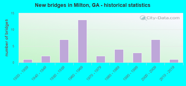
- New bridges - historical statistics
- 11930-1939
- 21940-1949
- 71950-1959
- 131960-1969
- 21970-1979
- 41980-1989
- 31990-1999
- 72000-2009
- 12010-2019

- Reconstructed bridges - Historical Statistics
- 11950-1959
- 01960-1969
- 01970-1979
- 11980-1989


- Bridge Condition - Deck
- 3.8%Very good
- 46.2%Good
- 23.1%Satisfactory
- 26.9%Fair

- Bridge Condition - Superstructure
- 3.8%Very good
- 50.0%Good
- 23.1%Satisfactory
- 23.1%Fair

- Bridge Condition - Substructure
- 3.8%Very good
- 65.4%Good
- 23.1%Satisfactory
- 7.7%Fair

- Bridge Condition - Channel
- 15.0%Very good
- 72.5%Good
- 7.5%Satisfactory
- 2.5%Fair
- 2.5%Poor

- Bridge Condition - Culverts
- 7.1%Very good
- 92.9%Good
Find on map >> Show street view
Structure Number: 575023, Location: 8 MI E OF CANTON (Lat: 34.223728, Lng: -84.355547), Route carried "on" structure: County highway 274, Year Built: 1985, Status: Open, Structure Length: 1.22m (4.00ft), Average Daily Traffic: 600 (year 2011), Truck Traffic: 1%, Average Future Daily Traffic: 900 (year 2031), Design Load: HS 20+Mod, Features Intersected: MILL CREEK, Facility Carried by Structure: GADDIS ROAD
Minimum Vertical Clearance: 30+ m (98+ ft), Kilometerpoint: 3.219, Lanes on structure: 2, Base Highway Network: Yes, Owner: County Highway Agency, Approaching Roadway Width: 7.3m (24.0ft), Skew: 1 degrees, Material/Design: Concrete, Design/Construction: Culvert, Number Of Spans In Main Unit: 4, Length of Maximum Span: 2.7m (8.9ft), Curb or Sidewalk Widths: Left: 1.5m (4.9ft), Right: 0.0m
Condition: Channel: Good, Culverts: Good, Operating Rating: 55.3 metric tons, Method Used To Determine Operating Rating: Field evaluation and documented engineering judgment, Inventory Rating: 32.6 metric tons, Method Used To Determine Inventory Rating: Field evaluation and documented engineering judgment, Structural Evaluation: Better than present minimum criteria, Waterway Adequacy: Better than present minimum criteria, Approach Roadway Alignment: Equal to present desirable criteria, Designated Inspection Frequency: Every 24 months, Inspection Date: April 2020, Bridge Improvement Cost: $156,000, Roadway Improvement Cost: $16,000, Total Project Cost: $234,000
Find on map >> Show street view
Structure Number: 575078, Location: 10 MI SE OF CANTON (Lat: 34.187878, Lng: -84.325189), Route carried "on" structure: County highway 257, Year Built: 2000, Status: Open, Structure Length: 1.07m (3.51ft), Average Daily Traffic: 600 (year 2011), Truck Traffic: 1%, Average Future Daily Traffic: 900 (year 2031), Design Load: HS 20+Mod, Features Intersected: LITTLE RIVER, Facility Carried by Structure: LIBERTY HILL ROAD
Minimum Vertical Clearance: 30+ m (98+ ft), Kilometerpoint: 3.219, Lanes on structure: 2, Base Highway Network: Yes, Owner: County Highway Agency, Approaching Roadway Width: 6.7m (22.0ft), Skew: 2 degrees, Material/Design: Concrete, Design/Construction: Culvert, Number Of Spans In Main Unit: 3, Length of Maximum Span: 3.4m (11.2ft)
Condition: Channel: Very good, Culverts: Good, Operating Rating: 55.3 metric tons, Method Used To Determine Operating Rating: Field evaluation and documented engineering judgment, Inventory Rating: 32.6 metric tons, Method Used To Determine Inventory Rating: Field evaluation and documented engineering judgment, Structural Evaluation: Better than present minimum criteria, Waterway Adequacy: Better than present minimum criteria, Approach Roadway Alignment: Equal to present minimum criteria, Designated Inspection Frequency: Every 24 months, Inspection Date: April 2020, Bridge Improvement Cost: $137,000, Roadway Improvement Cost: $14,000, Total Project Cost: $205,000
Find on map >> Show street view
Structure Number: 575086, Location: 7 MI E OF HOLLY SPRINGS (Lat: 34.166939, Lng: -84.372647), Route carried "on" structure: County highway 2226, Year Built: 2003, Status: Open, Structure Length: 0.70m (2.30ft), Average Daily Traffic: 310 (year 2011), Truck Traffic: 6%, Average Future Daily Traffic: 465 (year 2031), Design Load: H 15, Features Intersected: LITTLE RIVER TRIB, Facility Carried by Structure: SAVANNA ESTATES DR
Minimum Vertical Clearance: 30+ m (98+ ft), Kilometerpoint: 0.000, Lanes on structure: 2, Base Highway Network: Yes, Owner: County Highway Agency, Approaching Roadway Width: 6.7m (22.0ft), Material/Design: Steel, Design/Construction: Culvert, Number Of Spans In Main Unit: 2, Length of Maximum Span: 3.0m (9.8ft)
Condition: Channel: Very good, Culverts: Good, Operating Rating: 41.7 metric tons, Method Used To Determine Operating Rating: Field evaluation and documented engineering judgment, Inventory Rating: 24.4 metric tons, Method Used To Determine Inventory Rating: Field evaluation and documented engineering judgment, Structural Evaluation: Equal to present minimum criteria, Waterway Adequacy: Equal to present desirable criteria, Approach Roadway Alignment: Equal to present desirable criteria, Designated Inspection Frequency: Every 24 months, Inspection Date: April 2020, Bridge Improvement Cost: $90,000, Roadway Improvement Cost: $9,000, Total Project Cost: $135,000
Find on map >> Show street view
Structure Number: 575091, Location: 8.2 MI E OF CANTON (Lat: 34.231828, Lng: -84.347547), Route carried "on" structure: County highway 2180, Year Built: 2003, Status: Open, Structure Length: 0.70m (2.30ft), Average Daily Traffic: 600 (year 2011), Truck Traffic: 1%, Average Future Daily Traffic: 900 (year 2031), Design Load: H 15, Features Intersected: MILL CREEK, Facility Carried by Structure: GRANDMAR CHASE
Minimum Vertical Clearance: 30+ m (98+ ft), Kilometerpoint: 1.609, Lanes on structure: 2, Base Highway Network: Yes, Owner: County Highway Agency, Approaching Roadway Width: 7.0m (23.0ft), Material/Design: Steel, Design/Construction: Culvert, Number Of Spans In Main Unit: 3, Length of Maximum Span: 2.1m (6.9ft)
Condition: Channel: Very good, Culverts: Good, Operating Rating: 43.5 metric tons, Method Used To Determine Operating Rating: Field evaluation and documented engineering judgment, Inventory Rating: 24.4 metric tons, Method Used To Determine Inventory Rating: Field evaluation and documented engineering judgment, Structural Evaluation: Equal to present minimum criteria, Waterway Adequacy: Superior to present desirable criteria, Approach Roadway Alignment: Equal to present desirable criteria, Designated Inspection Frequency: Every 24 months, Inspection Date: April 2020, Bridge Improvement Cost: $90,000, Roadway Improvement Cost: $9,000, Total Project Cost: $135,000
Find on map >> Show street view
Structure Number: 575092, Location: 8.2 MI W OF CANTON (Lat: 34.224608, Lng: -84.342978), Route carried "on" structure: County highway 2180, Year Built: 2003, Status: Open, Structure Length: 0.64m (2.10ft), Average Daily Traffic: 600 (year 2011), Truck Traffic: 1%, Average Future Daily Traffic: 900 (year 2031), Design Load: H 15, Features Intersected: MILL CREEK TRIB, Facility Carried by Structure: GRANDMAR CHASE
Minimum Vertical Clearance: 30+ m (98+ ft), Kilometerpoint: 1.609, Lanes on structure: 2, Base Highway Network: Yes, Owner: County Highway Agency, Approaching Roadway Width: 7.0m (23.0ft), Material/Design: Concrete, Design/Construction: Culvert, Number Of Spans In Main Unit: 2, Length of Maximum Span: 3.0m (9.8ft)
Condition: Channel: Very good, Culverts: Good, Operating Rating: 43.5 metric tons, Method Used To Determine Operating Rating: Field evaluation and documented engineering judgment, Inventory Rating: 24.4 metric tons, Method Used To Determine Inventory Rating: Field evaluation and documented engineering judgment, Structural Evaluation: Equal to present minimum criteria, Waterway Adequacy: Equal to present desirable criteria, Approach Roadway Alignment: Equal to present desirable criteria, Designated Inspection Frequency: Every 24 months, Inspection Date: April 2020, Bridge Improvement Cost: $82,000, Roadway Improvement Cost: $8,000, Total Project Cost: $123,000
Find on map >> Show street view
Structure Number: 5751, Location: 4.6 MILES EAST OF HICKORY (Lat: 34.182867, Lng: -84.346931), Route carried "on" structure: County highway 800, Year Built: 1980, Status: Open, Structure Length: 0.82m (2.69ft), Average Daily Traffic: 430 (year 2011), Truck Traffic: 8%, Average Future Daily Traffic: 645 (year 2031), Design Load: H 15, Features Intersected: LITTLE RIVER, Facility Carried by Structure: ANTIOCH ROAD
Minimum Vertical Clearance: 30+ m (98+ ft), Kilometerpoint: 0.000, Lanes on structure: 2, Base Highway Network: Yes, Owner: County Highway Agency, Maintenance Responsibility: City or Municipal Highway Agency, Approaching Roadway Width: 7.3m (24.0ft), Material/Design: Steel, Design/Construction: Culvert, Number Of Spans In Main Unit: 3, Length of Maximum Span: 1.8m (5.9ft)
Condition: Channel: Good, Culverts: Very good, Operating Rating: 40.8 metric tons, Method Used To Determine Operating Rating: Field evaluation and documented engineering judgment, Inventory Rating: 24.4 metric tons, Method Used To Determine Inventory Rating: Field evaluation and documented engineering judgment, Structural Evaluation: Equal to present minimum criteria, Waterway Adequacy: Better than present minimum criteria, Approach Roadway Alignment: Equal to present desirable criteria, Length Of Structure Improvement: 0.99m (3.25ft), Designated Inspection Frequency: Every 24 months, Inspection Date: May 2020, Bridge Improvement Cost: $2,397,000, Roadway Improvement Cost: $239,000, Total Project Cost: $3,596,000 ( Estimate for 2014)
Find on map >> Show street view
Structure Number: 575111, Location: CHEROKEE-FULTON C L (Lat: 34.118331, Lng: -84.388317), Route carried "on" structure: State highway 140, Year Built: 2018, Status: Open, Structure Length: 10.58m (34.71ft), Average Daily Traffic: 20,160 (year 2017), Truck Traffic: 1%, Average Future Daily Traffic: 25,920 (year 2037), Design Load: HS 20+Mod, Features Intersected: LITTLE RIVER
Minimum Vertical Clearance: 30+ m (98+ ft), Kilometerpoint: 43.452, Lanes on structure: 2, Base Highway Network: Yes, Owner: State Highway Agency, Approaching Roadway Width: 12.2m (40.0ft), Material/Design: Prestressed concrete, Design/Construction: Stringer/Multi-beam, Number Of Spans In Main Unit: 3, Length of Maximum Span: 36.6m (120.1ft), Curb-To-Curb Width: 12.2m (40.0ft), Out-to-Out Width: 14.6m (47.9ft)
Condition: Deck: Good, Superstructure: Good, Substructure: Good, Channel: Very good, Operating Rating: 68.0 metric tons, Method Used To Determine Operating Rating: Load Factor (LF), Inventory Rating: 40.8 metric tons, Method Used To Determine Inventory Rating: Load Factor (LF), Structural Evaluation: Better than present minimum criteria, Deck Geometry: Somewhat better than minimum adequacy, Waterway Adequacy: Equal to present desirable criteria, Approach Roadway Alignment: Equal to present minimum criteria, Length Of Structure Improvement: 12.68m (41.60ft), Designated Inspection Frequency: Every 24 months, Inspection Date: May 2020, Bridge Improvement Cost: $30,784,000, Roadway Improvement Cost: $3,078,000, Total Project Cost: $46,176,000 ( Estimate for 2019), Deck Structure Type: Concrete Cast-file-Place
Find on map >> Show street view
Structure Number: 1170023, Location: 5 MI SW OF CUMMING (Lat: 34.178739, Lng: -84.221069), Route carried "on" structure: County highway 455, Year Built: 1940, Year Reconstructed: 1956, Status: Open, Structure Length: 0.98m (3.22ft), Average Daily Traffic: 14,240 (year 2012), Truck Traffic: 1%, Average Future Daily Traffic: 21,360 (year 2032), Design Load: H 15, Features Intersected: BENTLEY CREEK, Facility Carried by Structure: POST ROAD
Minimum Vertical Clearance: 30+ m (98+ ft), Kilometerpoint: 3.219, Lanes on structure: 2, Base Highway Network: Yes, Owner: County Highway Agency, Approaching Roadway Width: 7.9m (25.9ft), Material/Design: Concrete, Design/Construction: Culvert, Number Of Spans In Main Unit: 3, Length of Maximum Span: 3.0m (9.8ft)
Condition: Channel: Good, Culverts: Good, Operating Rating: 59.8 metric tons, Method Used To Determine Operating Rating: Load Factor (LF), Inventory Rating: 36.2 metric tons, Method Used To Determine Inventory Rating: Load Factor (LF), Structural Evaluation: Better than present minimum criteria, Waterway Adequacy: Equal to present desirable criteria, Approach Roadway Alignment: Better than present minimum criteria, Designated Inspection Frequency: Every 24 months, Inspection Date: May 2021, Bridge Improvement Cost: $125,000, Roadway Improvement Cost: $13,000, Total Project Cost: $188,000
Find on map >> Show street view
Structure Number: 1175002, Location: 4 MI W OF CUMMING (Lat: 34.192425, Lng: -84.210931), Route carried "on" structure: County highway 836, Year Built: 1979, Status: Open, Structure Length: 1.34m (4.40ft), Average Daily Traffic: 2,270 (year 2012), Truck Traffic: 2%, Average Future Daily Traffic: 3,405 (year 2032), Design Load: HS 20+Mod, Features Intersected: CHEATAM CREEK, Facility Carried by Structure: PITTMAN ROAD
Minimum Vertical Clearance: 30+ m (98+ ft), Kilometerpoint: 1.609, Lanes on structure: 2, Base Highway Network: Yes, Owner: County Highway Agency, Approaching Roadway Width: 6.1m (20.0ft), Skew: 1 degrees, Material/Design: Concrete, Design/Construction: Culvert, Number Of Spans In Main Unit: 4, Length of Maximum Span: 3.0m (9.8ft)
Condition: Channel: Satisfactory, Culverts: Good, Operating Rating: 55.3 metric tons, Method Used To Determine Operating Rating: Field evaluation and documented engineering judgment, Inventory Rating: 32.6 metric tons, Method Used To Determine Inventory Rating: Field evaluation and documented engineering judgment, Structural Evaluation: Better than present minimum criteria, Waterway Adequacy: Equal to present desirable criteria, Approach Roadway Alignment: Somewhat better than minimum adequacy, Designated Inspection Frequency: Every 24 months, Inspection Date: May 2021, Bridge Improvement Cost: $172,000, Roadway Improvement Cost: $17,000, Total Project Cost: $258,000
Find on map >> Show street view
Structure Number: 1175004, Location: 5.2 MI W OF CUMMING (Lat: 34.193389, Lng: -84.228089), Route carried "on" structure: County highway 26, Year Built: 1973, Status: Open, Structure Length: 0.98m (3.22ft), Average Daily Traffic: 2,510 (year 2012), Truck Traffic: 1%, Average Future Daily Traffic: 3,765 (year 2032), Design Load: HS 20+Mod, Features Intersected: BENTLEY CREEK, Facility Carried by Structure: BENTLEY ROAD
Minimum Vertical Clearance: 30+ m (98+ ft), Kilometerpoint: 0.000, Lanes on structure: 2, Base Highway Network: Yes, Owner: County Highway Agency, Approaching Roadway Width: 6.1m (20.0ft), Material/Design: Concrete, Design/Construction: Culvert, Number Of Spans In Main Unit: 3, Length of Maximum Span: 3.0m (9.8ft)
Condition: Channel: Good, Culverts: Good, Operating Rating: 55.3 metric tons, Method Used To Determine Operating Rating: Field evaluation and documented engineering judgment, Inventory Rating: 32.6 metric tons, Method Used To Determine Inventory Rating: Field evaluation and documented engineering judgment, Structural Evaluation: Better than present minimum criteria, Waterway Adequacy: Equal to present desirable criteria, Approach Roadway Alignment: Better than present minimum criteria, Designated Inspection Frequency: Every 24 months, Inspection Date: May 2021, Bridge Improvement Cost: $125,000, Roadway Improvement Cost: $13,000, Total Project Cost: $188,000
Find on map >> Show street view
Structure Number: 1175021, Location: 4.8 MI SW OF CUMMING (Lat: 34.169158, Lng: -84.209639), Route carried "on" structure: County highway 53, Year Built: 1996, Status: Open, Structure Length: 3.05m (10.01ft), Average Daily Traffic: 1,930 (year 2012), Truck Traffic: 1%, Average Future Daily Traffic: 2,895 (year 2032), Design Load: HS 20, Features Intersected: BIG CREEK, Facility Carried by Structure: MAJORS ROAD
Minimum Vertical Clearance: 30+ m (98+ ft), Kilometerpoint: 9.656, Lanes on structure: 2, Base Highway Network: Yes, Owner: County Highway Agency, Approaching Roadway Width: 6.1m (20.0ft), Material/Design: Steel, Design/Construction: Stringer/Multi-beam, Number Of Spans In Main Unit: 3, Length of Maximum Span: 18.3m (60.0ft), Curb-To-Curb Width: 7.6m (24.9ft), Out-to-Out Width: 8.5m (27.9ft)
Condition: Deck: Good, Superstructure: Good, Substructure: Good, Channel: Good, Operating Rating: 89.8 metric tons, Method Used To Determine Operating Rating: Load Factor (LF), Inventory Rating: 59.8 metric tons, Method Used To Determine Inventory Rating: Load Factor (LF), Structural Evaluation: Better than present minimum criteria, Deck Geometry: Meets minimum limits, Waterway Adequacy: Equal to present desirable criteria, Approach Roadway Alignment: Equal to present minimum criteria, Designated Inspection Frequency: Every 24 months, Inspection Date: May 2021, Bridge Improvement Cost: $391,000, Roadway Improvement Cost: $39,000, Total Project Cost: $586,000, Deck Structure Type: Concrete Cast-file-Place
Find on map >> Show street view
Structure Number: 1175031, Location: 3.8 MI SW OF CUMMING (Lat: 34.182997, Lng: -84.207689), Route carried "on" structure: County highway 837, Year Built: 1990, Status: Open, Structure Length: 1.58m (5.18ft), Average Daily Traffic: 1,710 (year 2012), Truck Traffic: 1%, Average Future Daily Traffic: 2,565 (year 2032), Design Load: H 15, Features Intersected: CHEATAM CREEK, Facility Carried by Structure: POLO DRIVE
Minimum Vertical Clearance: 30+ m (98+ ft), Kilometerpoint: 1.609, Lanes on structure: 2, Base Highway Network: Yes, Owner: County Highway Agency, Approaching Roadway Width: 7.0m (23.0ft), Material/Design: Concrete, Design/Construction: Culvert, Number Of Spans In Main Unit: 3, Length of Maximum Span: 3.7m (12.1ft)
Condition: Channel: Good, Culverts: Good, Operating Rating: 41.7 metric tons, Method Used To Determine Operating Rating: Field evaluation and documented engineering judgment, Inventory Rating: 24.4 metric tons, Method Used To Determine Inventory Rating: Field evaluation and documented engineering judgment, Structural Evaluation: Equal to present minimum criteria, Waterway Adequacy: Better than present minimum criteria, Approach Roadway Alignment: Better than present minimum criteria, Designated Inspection Frequency: Every 24 months, Inspection Date: May 2021, Bridge Improvement Cost: $203,000, Roadway Improvement Cost: $20,000, Total Project Cost: $305,000
Find on map >> Show street view
Structure Number: 1175039, Location: 4.3 MI W OF CUMMING (Lat: 34.208614, Lng: -84.226353), Route carried "on" structure: County highway 5, Year Built: 2004, Status: Open, Structure Length: 1.07m (3.51ft), Average Daily Traffic: 2,202 (year 2012), Truck Traffic: 1%, Average Future Daily Traffic: 3,303 (year 2030), Design Load: HS 20, Features Intersected: HARRIS CREEK, Facility Carried by Structure: DREW CAMPGROUND RO
Minimum Vertical Clearance: 30+ m (98+ ft), Kilometerpoint: 4.828, Lanes on structure: 2, Owner: County Highway Agency, Approaching Roadway Width: 8.2m (26.9ft), Material/Design: Concrete, Design/Construction: Culvert, Number Of Spans In Main Unit: 4, Length of Maximum Span: 2.4m (7.9ft), Curb or Sidewalk Widths: Left: 1.5m (4.9ft), Right: 1.5m (4.9ft)
Condition: Channel: Very good, Culverts: Good, Operating Rating: 55.3 metric tons, Method Used To Determine Operating Rating: Field evaluation and documented engineering judgment, Inventory Rating: 32.6 metric tons, Method Used To Determine Inventory Rating: Field evaluation and documented engineering judgment, Structural Evaluation: Better than present minimum criteria, Waterway Adequacy: Superior to present desirable criteria, Approach Roadway Alignment: Equal to present desirable criteria, Designated Inspection Frequency: Every 24 months, Inspection Date: May 2021, Bridge Improvement Cost: $137,000, Roadway Improvement Cost: $14,000, Total Project Cost: $205,000
Find on map >> Show street view
Structure Number: 117504, Location: 6 MI W OF CUMMING (Lat: 34.207411, Lng: -84.236642), Route carried "on" structure: County highway 99999, Year Built: 2005, Status: Open, Structure Length: 0.82m (2.69ft), Average Daily Traffic: 120 (year 2011), Truck Traffic: 1%, Average Future Daily Traffic: 180 (year 2031), Design Load: HS 20, Features Intersected: COBB CREEK, Facility Carried by Structure: WINTERBERRY ROAD
Minimum Vertical Clearance: 30+ m (98+ ft), Kilometerpoint: 0.000, Lanes on structure: 2, Owner: County Highway Agency, Approaching Roadway Width: 7.0m (23.0ft), Skew: 4 degrees, Material/Design: Concrete, Design/Construction: Culvert, Number Of Spans In Main Unit: 1, Length of Maximum Span: 8.2m (26.9ft), Curb or Sidewalk Widths: Left: 1.5m (4.9ft), Right: 0.0m
Condition: Channel: Good, Culverts: Good, Structural Evaluation: Better than present minimum criteria, Waterway Adequacy: Equal to present desirable criteria, Approach Roadway Alignment: Equal to present desirable criteria, Designated Inspection Frequency: Every 24 months, Inspection Date: May 2021, Bridge Improvement Cost: $105,000, Roadway Improvement Cost: $11,000, Total Project Cost: $158,000
Find on map >> Show street view
Structure Number: 1210281, Location: 3.0 MI N OF ALPHARETTA (Lat: 34.112458, Lng: -84.316408), Route carried "on" structure: County highway 9373, Year Built: 1951, Status: Temporarily open, Structure Length: 1.83m (6.00ft), Average Daily Traffic: 3,360 (year 2011), Truck Traffic: 1%, Average Future Daily Traffic: 5,040 (year 2031), Features Intersected: COOPER SANDY CREEK, Facility Carried by Structure: BETHANY ROAD
Minimum Vertical Clearance: 30+ m (98+ ft), Kilometerpoint: 1.609, Lanes on structure: 2, Base Highway Network: Yes, Owner: City or Municipal Highway Agency, Approaching Roadway Width: 6.1m (20.0ft), Material/Design: Prestressed concrete, Design/Construction: Channel Beam, Number Of Spans In Main Unit: 2, Length of Maximum Span: 9.1m (29.9ft), Curb or Sidewalk Widths: Left: 0.1m (0.3ft), Right: 0.1m (0.3ft), Curb-To-Curb Width: 6.9m (22.6ft), Out-to-Out Width: 7.3m (24.0ft)
Condition: Deck: Good, Superstructure: Good, Substructure: Fair, Channel: Satisfactory, Operating Rating: 19.9 metric tons, Method Used To Determine Operating Rating: Load Factor (LF), Inventory Rating: 14.5 metric tons, Method Used To Determine Inventory Rating: Load Factor (LF), Structural Evaluation: Meets minimum limits, Deck Geometry: High priority of replacement, Waterway Adequacy: Better than present minimum criteria, Approach Roadway Alignment: Equal to present desirable criteria, Length Of Structure Improvement: 42.06m (137.99ft), Designated Inspection Frequency: Every 24 months, Inspection Date: November 2021, Bridge Improvement Cost: $234,000, Roadway Improvement Cost: $23,000, Total Project Cost: $352,000, Deck Structure Type: Concrete Precast Panels, Wearing Surface/Protective System: Wearing Surface: Bituminous
Find on map >> Show street view
Structure Number: 1210282, Location: 3.6 MI N OF ALPHARETTA (Lat: 34.128608, Lng: -84.300089), Route carried "on" structure: County highway 2365, Year Built: 1995, Status: Open, Structure Length: 0.82m (2.69ft), Average Daily Traffic: 13,694 (year 2011), Truck Traffic: 1%, Average Future Daily Traffic: 20,541 (year 2031), Design Load: HS 20+Mod, Features Intersected: CHICKEN CREEK TRIB, Facility Carried by Structure: HOPEWELL ROAD
Minimum Vertical Clearance: 30+ m (98+ ft), Kilometerpoint: 1.609, Lanes on structure: 2, Base Highway Network: Yes, Owner: City or Municipal Highway Agency, Approaching Roadway Width: 7.3m (24.0ft), Skew: 1 degrees, Material/Design: Concrete, Design/Construction: Culvert, Number Of Spans In Main Unit: 3, Length of Maximum Span: 2.4m (7.9ft)
Condition: Channel: Good, Culverts: Good, Operating Rating: 55.3 metric tons, Method Used To Determine Operating Rating: Field evaluation and documented engineering judgment, Inventory Rating: 32.6 metric tons, Method Used To Determine Inventory Rating: Field evaluation and documented engineering judgment, Structural Evaluation: Better than present minimum criteria, Waterway Adequacy: Equal to present desirable criteria, Approach Roadway Alignment: Equal to present desirable criteria, Designated Inspection Frequency: Every 24 months, Inspection Date: October 2021, Bridge Improvement Cost: $105,000, Roadway Improvement Cost: $11,000, Total Project Cost: $158,000
Find on map >> Show street view
Structure Number: 1210283, Location: 5.8 MI N OF ALPHARETTA (Lat: 34.159908, Lng: -84.288408), Route carried "on" structure: County highway 2365, Year Built: 1948, Status: Posted for load, Structure Length: 1.25m (4.10ft), Average Daily Traffic: 13,694 (year 2011), Truck Traffic: 1%, Average Future Daily Traffic: 20,541 (year 2031), Features Intersected: CHICKEN CREEK, Facility Carried by Structure: HOPEWELL ROAD
Minimum Vertical Clearance: 30+ m (98+ ft), Kilometerpoint: 6.437, Lanes on structure: 2, Base Highway Network: Yes, Owner: City or Municipal Highway Agency, Approaching Roadway Width: 6.1m (20.0ft), Material/Design: Steel, Design/Construction: Stringer/Multi-beam, Number Of Spans In Main Unit: 1, Length of Maximum Span: 12.5m (41.0ft), Curb or Sidewalk Widths: Left: 0.2m (0.7ft), Right: 0.2m (0.7ft), Curb-To-Curb Width: 7.2m (23.6ft), Out-to-Out Width: 8.4m (27.6ft)
Condition: Deck: Good, Superstructure: Good, Substructure: Good, Channel: Good, Operating Rating: 33.5 metric tons, Method Used To Determine Operating Rating: Load Factor (LF), Inventory Rating: 19.9 metric tons, Method Used To Determine Inventory Rating: Load Factor (LF), Structural Evaluation: Somewhat better than minimum adequacy, Deck Geometry: High priority of replacement, Waterway Adequacy: Equal to present desirable criteria, Approach Roadway Alignment: Equal to present minimum criteria, Bridge Posting: Required (Relationship of Operating Rating to Maximum Legal Load: 0.1 - 9.9% below), Length Of Structure Improvement: 41.48m (136.09ft), Designated Inspection Frequency: Every 24 months, Inspection Date: November 2021, Bridge Improvement Cost: $160,000, Roadway Improvement Cost: $16,000, Total Project Cost: $240,000, Deck Structure Type: Concrete Cast-file-Place, Wearing Surface/Protective System: Wearing Surface: Bituminous, Membrane: Built-up
Find on map >> Show street view
Structure Number: 1210284, Location: 3.2 MI NE OF ALPHARETTA (Lat: 34.104597, Lng: -84.251400), Route carried "on" structure: City street 2564, Year Built: 1954, Status: Posted for load, Structure Length: 1.83m (6.00ft), Average Daily Traffic: 1,500 (year 2011), Truck Traffic: 1%, Average Future Daily Traffic: 150 (year 2031), Design Load: H 15, Features Intersected: CAMP CREEK TRIB, Facility Carried by Structure: McGINNIS FERRY RD
Minimum Vertical Clearance: 30+ m (98+ ft), Kilometerpoint: 3.219, Lanes on structure: 2, Base Highway Network: Yes, Owner: City or Municipal Highway Agency, Approaching Roadway Width: 6.1m (20.0ft), Material/Design: Prestressed concrete, Design/Construction: Channel Beam, Number Of Spans In Main Unit: 2, Length of Maximum Span: 9.1m (29.9ft), Curb or Sidewalk Widths: Left: 0.2m (0.7ft), Right: 0.2m (0.7ft), Curb-To-Curb Width: 6.9m (22.6ft), Out-to-Out Width: 7.4m (24.3ft)
Condition: Deck: Satisfactory, Superstructure: Satisfactory, Substructure: Satisfactory, Channel: Good, Operating Rating: 27.2 metric tons, Method Used To Determine Operating Rating: Load Factor (LF), Inventory Rating: 16.3 metric tons, Method Used To Determine Inventory Rating: Load Factor (LF), Structural Evaluation: Meets minimum limits, Deck Geometry: High priority of corrective action, Waterway Adequacy: Better than present minimum criteria, Approach Roadway Alignment: Better than present minimum criteria, Bridge Posting: Required (Relationship of Operating Rating to Maximum Legal Load: 0.1 - 9.9% below), Length Of Structure Improvement: 42.06m (137.99ft), Designated Inspection Frequency: Every 24 months, Inspection Date: September 2021, Bridge Improvement Cost: $234,000, Roadway Improvement Cost: $23,000, Total Project Cost: $352,000, Deck Structure Type: Concrete Precast Panels, Wearing Surface/Protective System: Wearing Surface: Bituminous, Membrane: Built-up
Find on map >> Show street view
Structure Number: 1210698, Location: 4.7 MI NW OF ALPHARETTA (Lat: 34.129619, Lng: -84.343950), Route carried "on" structure: State highway 372, Year Built: 1989, Status: Open, Structure Length: 3.66m (12.01ft), Average Daily Traffic: 6,480 (year 2011), Truck Traffic: 1%, Average Future Daily Traffic: 9,720 (year 2031), Design Load: HS 20+Mod, Features Intersected: CHICKEN CREEK, Facility Carried by Structure: BIRMINGHAM HWY
Minimum Vertical Clearance: 30+ m (98+ ft), Kilometerpoint: 6.437, Lanes on structure: 2, Base Highway Network: Yes, Owner: State Highway Agency, Approaching Roadway Width: 7.3m (24.0ft), Skew: 2 degrees, Material/Design: Concrete, Design/Construction: Tee Beam, Number Of Spans In Main Unit: 3, Length of Maximum Span: 12.2m (40.0ft), Curb-To-Curb Width: 13.4m (44.0ft), Out-to-Out Width: 14.4m (47.2ft)
Condition: Deck: Good, Superstructure: Good, Substructure: Good, Channel: Good, Operating Rating: 34.4 metric tons, Method Used To Determine Operating Rating: Load Factor (LF), Inventory Rating: 16.3 metric tons, Method Used To Determine Inventory Rating: Load Factor (LF), Structural Evaluation: Meets minimum limits, Deck Geometry: Equal to present minimum criteria, Waterway Adequacy: Equal to present desirable criteria, Approach Roadway Alignment: Equal to present desirable criteria, Designated Inspection Frequency: Every 24 months, Inspection Date: November 2021, Bridge Improvement Cost: $469,000, Roadway Improvement Cost: $47,000, Total Project Cost: $703,000, Deck Structure Type: Concrete Precast Panels
Find on map >> Show street view
Structure Number: 1215002, Location: 8 MI NW OF ALPHARETTA (Lat: 34.176828, Lng: -84.351839), Route carried "on" structure: County highway 3, Year Built: 1954, Status: Posted for load, Structure Length: 1.46m (4.79ft), Average Daily Traffic: 1,940 (year 2011), Truck Traffic: 1%, Average Future Daily Traffic: 2,910 (year 2031), Features Intersected: LITTLE RIVER, Facility Carried by Structure: CLARITY ROAD
Minimum Vertical Clearance: 30+ m (98+ ft), Kilometerpoint: 0.000, Lanes on structure: 1, Base Highway Network: Yes, Owner: City or Municipal Highway Agency, Approaching Roadway Width: 4.6m (15.1ft), Material/Design: Steel, Design/Construction: Stringer/Multi-beam, Number Of Spans In Main Unit: 1, Length of Maximum Span: 14.6m (47.9ft), Curb-To-Curb Width: 4.1m (13.5ft), Out-to-Out Width: 4.5m (14.8ft)
Condition: Deck: Satisfactory, Superstructure: Satisfactory, Substructure: Good, Channel: Good, Operating Rating: 9.9 metric tons, Method Used To Determine Operating Rating: Allowable Stress (AS), Inventory Rating: 7.2 metric tons, Method Used To Determine Inventory Rating: Allowable Stress (AS), Structural Evaluation: High priority of replacement, Deck Geometry: High priority of replacement, Waterway Adequacy: Better than present minimum criteria, Approach Roadway Alignment: High priority of corrective action, Bridge Posting: Required (Relationship of Operating Rating to Maximum Legal Load: > 39.9% below), Length Of Structure Improvement: 162.40m (532.81ft), Designated Inspection Frequency: Every 24 months, Inspection Date: November 2021, Bridge Improvement Cost: $136,000, Roadway Improvement Cost: $14,000, Total Project Cost: $205,000, Deck Structure Type: Wood or Timber
Find on map >> Show street view
Structure Number: 1215003, Location: 6 MI N OF ALPHARETTA (Lat: 34.164039, Lng: -84.289297), Route carried "on" structure: County highway 4, Year Built: 1961, Year Reconstructed: 1994, Status: Posted for load, Structure Length: 0.91m (2.99ft), Average Daily Traffic: 5,760 (year 2011), Truck Traffic: 1%, Average Future Daily Traffic: 8,640 (year 2031), Design Load: H 15, Features Intersected: CHICKEN CREEK TRIB, Facility Carried by Structure: BIRMINGHAM ROAD
Minimum Vertical Clearance: 30+ m (98+ ft), Kilometerpoint: 6.437, Lanes on structure: 2, Base Highway Network: Yes, Owner: City or Municipal Highway Agency, Approaching Roadway Width: 6.4m (21.0ft), Skew: 1 degrees, Material/Design: Prestressed concrete, Design/Construction: Channel Beam, Number Of Spans In Main Unit: 1, Length of Maximum Span: 9.1m (29.9ft), Curb or Sidewalk Widths: Left: 0.1m (0.3ft), Right: 0.1m (0.3ft), Curb-To-Curb Width: 6.9m (22.6ft), Out-to-Out Width: 7.4m (24.3ft)
Condition: Deck: Fair, Superstructure: Fair, Substructure: Satisfactory, Channel: Good, Operating Rating: 29.0 metric tons, Method Used To Determine Operating Rating: Allowable Stress (AS), Inventory Rating: 17.2 metric tons, Method Used To Determine Inventory Rating: Allowable Stress (AS), Structural Evaluation: Meets minimum limits, Deck Geometry: High priority of replacement, Waterway Adequacy: Equal to present desirable criteria, Approach Roadway Alignment: Better than present minimum criteria, Bridge Posting: Required (Relationship of Operating Rating to Maximum Legal Load: 10.0 - 19.9% below), Length Of Structure Improvement: 41.15m (135.01ft), Designated Inspection Frequency: Every 24 months, Inspection Date: November 2021, Bridge Improvement Cost: $117,000, Roadway Improvement Cost: $12,000, Total Project Cost: $176,000, Deck Structure Type: Concrete Precast Panels, Wearing Surface/Protective System: Wearing Surface: Bituminous
Find on map >> Show street view
Structure Number: 1215004, Location: 6 MI N OF ALPHARETTA (Lat: 34.164769, Lng: -84.272639), Route carried "on" structure: County highway 12, Year Built: 1964, Status: Posted for load, Structure Length: 1.83m (6.00ft), Average Daily Traffic: 1,940 (year 2011), Truck Traffic: 1%, Average Future Daily Traffic: 2,910 (year 2031), Design Load: H 15, Features Intersected: CHICKEN CREEK, Facility Carried by Structure: HAMBY ROAD
Minimum Vertical Clearance: 30+ m (98+ ft), Kilometerpoint: 0.000, Lanes on structure: 2, Base Highway Network: Yes, Owner: City or Municipal Highway Agency, Approaching Roadway Width: 6.1m (20.0ft), Material/Design: Concrete, Design/Construction: Slab, Number Of Spans In Main Unit: 2, Length of Maximum Span: 9.1m (29.9ft), Curb or Sidewalk Widths: Left: 0.1m (0.3ft), Right: 0.1m (0.3ft), Curb-To-Curb Width: 6.9m (22.6ft), Out-to-Out Width: 7.4m (24.3ft)
Condition: Deck: Satisfactory, Superstructure: Satisfactory, Substructure: Good, Channel: Good, Operating Rating: 33.5 metric tons, Method Used To Determine Operating Rating: Load Factor (LF), Inventory Rating: 19.9 metric tons, Method Used To Determine Inventory Rating: Load Factor (LF), Structural Evaluation: Somewhat better than minimum adequacy, Deck Geometry: High priority of corrective action, Waterway Adequacy: Equal to present desirable criteria, Approach Roadway Alignment: Equal to present desirable criteria, Bridge Posting: Required (Relationship of Operating Rating to Maximum Legal Load: 0.1 - 9.9% below), Length Of Structure Improvement: 42.06m (137.99ft), Designated Inspection Frequency: Every 24 months, Inspection Date: November 2021, Bridge Improvement Cost: $234,000, Roadway Improvement Cost: $23,000, Total Project Cost: $352,000, Deck Structure Type: Concrete Precast Panels, Wearing Surface/Protective System: Wearing Surface: Bituminous
Find on map >> Show street view
Structure Number: 1215005, Location: 6 MI N OF ALPHARETTA (Lat: 34.159597, Lng: -84.267169), Route carried "on" structure: County highway 12, Year Built: 1966, Status: Posted for load, Structure Length: 0.91m (2.99ft), Average Daily Traffic: 1,940 (year 2011), Truck Traffic: 1%, Average Future Daily Traffic: 2,910 (year 2031), Design Load: H 15, Features Intersected: CHICKEN CREEK TRIB, Facility Carried by Structure: HAMBY ROAD
Minimum Vertical Clearance: 30+ m (98+ ft), Kilometerpoint: 1.609, Lanes on structure: 2, Base Highway Network: Yes, Owner: City or Municipal Highway Agency, Approaching Roadway Width: 6.1m (20.0ft), Material/Design: Prestressed concrete, Design/Construction: Channel Beam, Number Of Spans In Main Unit: 1, Length of Maximum Span: 9.1m (29.9ft), Curb or Sidewalk Widths: Left: 0.1m (0.3ft), Right: 0.1m (0.3ft), Curb-To-Curb Width: 6.9m (22.6ft), Out-to-Out Width: 7.4m (24.3ft)
Condition: Deck: Good, Superstructure: Good, Substructure: Good, Channel: Good, Operating Rating: 33.5 metric tons, Method Used To Determine Operating Rating: Load Factor (LF), Inventory Rating: 19.9 metric tons, Method Used To Determine Inventory Rating: Load Factor (LF), Structural Evaluation: Somewhat better than minimum adequacy, Deck Geometry: High priority of corrective action, Waterway Adequacy: Equal to present desirable criteria, Approach Roadway Alignment: Equal to present desirable criteria, Bridge Posting: Required (Relationship of Operating Rating to Maximum Legal Load: 0.1 - 9.9% below), Length Of Structure Improvement: 41.15m (135.01ft), Designated Inspection Frequency: Every 24 months, Inspection Date: November 2021, Bridge Improvement Cost: $117,000, Roadway Improvement Cost: $12,000, Total Project Cost: $176,000, Deck Structure Type: Concrete Precast Panels, Wearing Surface/Protective System: Wearing Surface: Bituminous
Find on map >> Show street view
Structure Number: 1215006, Location: 7 MI N OF ALPHARETTA (Lat: 34.175039, Lng: -84.267278), Route carried "on" structure: County highway 13, Year Built: 1964, Status: Open, Structure Length: 2.74m (8.99ft), Average Daily Traffic: 1,940 (year 2011), Truck Traffic: 1%, Average Future Daily Traffic: 2,910 (year 2031), Design Load: H 15, Features Intersected: CHICKEN CREEK TRIB, Facility Carried by Structure: LONGSTREET ROAD
Minimum Vertical Clearance: 30+ m (98+ ft), Kilometerpoint: 0.000, Lanes on structure: 2, Base Highway Network: Yes, Owner: City or Municipal Highway Agency, Approaching Roadway Width: 6.4m (21.0ft), Material/Design: Prestressed concrete, Design/Construction: Channel Beam, Number Of Spans In Main Unit: 3, Length of Maximum Span: 9.1m (29.9ft), Curb-To-Curb Width: 6.9m (22.6ft), Out-to-Out Width: 7.4m (24.3ft)
Condition: Deck: Good, Superstructure: Good, Substructure: Good, Channel: Good, Operating Rating: 33.5 metric tons, Method Used To Determine Operating Rating: Load Factor (LF), Inventory Rating: 20.8 metric tons, Method Used To Determine Inventory Rating: Load Factor (LF), Structural Evaluation: Somewhat better than minimum adequacy, Deck Geometry: High priority of corrective action, Waterway Adequacy: Equal to present desirable criteria, Approach Roadway Alignment: Equal to present minimum criteria, Length Of Structure Improvement: 42.98m (141.01ft), Designated Inspection Frequency: Every 24 months, Inspection Date: November 2021, Bridge Improvement Cost: $352,000, Roadway Improvement Cost: $35,000, Total Project Cost: $527,000, Deck Structure Type: Concrete Precast Panels, Wearing Surface/Protective System: Wearing Surface: Bituminous
Find on map >> Show street view
Structure Number: 1215007, Location: 7 MI N OF ALPHARETTA (Lat: 34.173958, Lng: -84.284478), Route carried "on" structure: County highway 18, Year Built: 1956, Status: Open, Structure Length: 0.91m (2.99ft), Average Daily Traffic: 1,940 (year 2011), Truck Traffic: 1%, Average Future Daily Traffic: 2,910 (year 2031), Design Load: H 15, Features Intersected: CHICKEN CREEK TRIB, Facility Carried by Structure: WESTBROOK ROAD
Minimum Vertical Clearance: 30+ m (98+ ft), Kilometerpoint: 1.609, Lanes on structure: 2, Base Highway Network: Yes, Owner: City or Municipal Highway Agency, Approaching Roadway Width: 5.5m (18.0ft), Skew: 4 degrees, Material/Design: Prestressed concrete, Design/Construction: Channel Beam, Number Of Spans In Main Unit: 1, Length of Maximum Span: 9.1m (29.9ft), Curb or Sidewalk Widths: Left: 0.1m (0.3ft), Right: 0.1m (0.3ft), Curb-To-Curb Width: 5.1m (16.7ft), Out-to-Out Width: 5.5m (18.0ft)
Condition: Deck: Fair, Superstructure: Fair, Substructure: Very good, Channel: Good, Operating Rating: 32.6 metric tons, Method Used To Determine Operating Rating: Allowable Stress (AS), Inventory Rating: 20.8 metric tons, Method Used To Determine Inventory Rating: Allowable Stress (AS), Structural Evaluation: Somewhat better than minimum adequacy, Deck Geometry: High priority of replacement, Waterway Adequacy: Better than present minimum criteria, Approach Roadway Alignment: Equal to present desirable criteria, Length Of Structure Improvement: 42.06m (137.99ft), Designated Inspection Frequency: Every 24 months, Inspection Date: November 2021, Bridge Improvement Cost: $117,000, Roadway Improvement Cost: $12,000, Total Project Cost: $176,000, Deck Structure Type: Concrete Precast Panels
Find on map >> Show street view
Structure Number: 1215008, Location: 7 MI N OF ALPHARETTA (Lat: 34.168289, Lng: -84.284469), Route carried "on" structure: County highway 18, Year Built: 1956, Status: Posted for load, Structure Length: 0.91m (2.99ft), Average Daily Traffic: 1,940 (year 2011), Truck Traffic: 1%, Average Future Daily Traffic: 2,910 (year 2031), Design Load: H 15, Features Intersected: CHICKEN CREEK TRIB, Facility Carried by Structure: WESTBROOK ROAD
Minimum Vertical Clearance: 30+ m (98+ ft), Kilometerpoint: 1.609, Lanes on structure: 2, Base Highway Network: Yes, Owner: City or Municipal Highway Agency, Approaching Roadway Width: 5.5m (18.0ft), Material/Design: Prestressed concrete, Design/Construction: Channel Beam, Number Of Spans In Main Unit: 1, Length of Maximum Span: 9.1m (29.9ft), Curb or Sidewalk Widths: Left: 0.1m (0.3ft), Right: 0.1m (0.3ft), Curb-To-Curb Width: 5.1m (16.7ft), Out-to-Out Width: 5.5m (18.0ft)
Condition: Deck: Fair, Superstructure: Fair, Substructure: Satisfactory, Channel: Good, Operating Rating: 18.1 metric tons, Method Used To Determine Operating Rating: Field evaluation and documented engineering judgment, Inventory Rating: 9.9 metric tons, Method Used To Determine Inventory Rating: Field evaluation and documented engineering judgment, Structural Evaluation: High priority of replacement, Deck Geometry: High priority of replacement, Waterway Adequacy: Better than present minimum criteria, Approach Roadway Alignment: Equal to present desirable criteria, Bridge Posting: Required (Relationship of Operating Rating to Maximum Legal Load: > 39.9% below), Length Of Structure Improvement: 42.06m (137.99ft), Designated Inspection Frequency: Every 24 months, Inspection Date: November 2021, Bridge Improvement Cost: $117,000, Roadway Improvement Cost: $12,000, Total Project Cost: $176,000, Deck Structure Type: Concrete Precast Panels
Find on map >> Show street view
Structure Number: 1215009, Location: 4 MI N OF ALPHARETTA (Lat: 34.133139, Lng: -84.307647), Route carried "on" structure: County highway 19, Year Built: 1962, Status: Open, Structure Length: 2.74m (8.99ft), Average Daily Traffic: 1,940 (year 2011), Truck Traffic: 1%, Average Future Daily Traffic: 2,910 (year 2031), Design Load: H 15, Features Intersected: CHICKEN CREEK TRIB, Facility Carried by Structure: THOMPSON ROAD
Minimum Vertical Clearance: 30+ m (98+ ft), Kilometerpoint: 0.000, Lanes on structure: 2, Base Highway Network: Yes, Owner: City or Municipal Highway Agency, Approaching Roadway Width: 6.1m (20.0ft), Material/Design: Prestressed concrete, Design/Construction: Channel Beam, Number Of Spans In Main Unit: 3, Length of Maximum Span: 9.1m (29.9ft), Curb or Sidewalk Widths: Left: 0.1m (0.3ft), Right: 0.1m (0.3ft), Curb-To-Curb Width: 7.0m (23.0ft), Out-to-Out Width: 7.4m (24.3ft)
Condition: Deck: Fair, Superstructure: Fair, Substructure: Good, Channel: Satisfactory, Operating Rating: 36.2 metric tons, Method Used To Determine Operating Rating: Load Factor (LF), Inventory Rating: 21.7 metric tons, Method Used To Determine Inventory Rating: Load Factor (LF), Structural Evaluation: Somewhat better than minimum adequacy, Deck Geometry: High priority of corrective action, Waterway Adequacy: Equal to present desirable criteria, Approach Roadway Alignment: Better than present minimum criteria, Length Of Structure Improvement: 42.98m (141.01ft), Designated Inspection Frequency: Every 24 months, Inspection Date: October 2021, Bridge Improvement Cost: $352,000, Roadway Improvement Cost: $35,000, Total Project Cost: $527,000, Deck Structure Type: Concrete Precast Panels, Wearing Surface/Protective System: Wearing Surface: Bituminous
Find on map >> Show street view
Structure Number: 121501, Location: 6 MI N OF ALPHARETTA (Lat: 34.153219, Lng: -84.307800), Route carried "on" structure: County highway 20, Year Built: 1965, Status: Open, Structure Length: 1.83m (6.00ft), Average Daily Traffic: 1,940 (year 2011), Truck Traffic: 1%, Average Future Daily Traffic: 2,910 (year 2031), Design Load: H 15, Features Intersected: CHICKEN CREEK, Facility Carried by Structure: DINSMORE ROAD
Minimum Vertical Clearance: 30+ m (98+ ft), Kilometerpoint: 1.609, Lanes on structure: 2, Base Highway Network: Yes, Owner: City or Municipal Highway Agency, Approaching Roadway Width: 6.4m (21.0ft), Material/Design: Prestressed concrete, Design/Construction: Channel Beam, Number Of Spans In Main Unit: 2, Length of Maximum Span: 9.1m (29.9ft), Curb or Sidewalk Widths: Left: 0.1m (0.3ft), Right: 0.1m (0.3ft), Curb-To-Curb Width: 10.7m (35.1ft), Out-to-Out Width: 11.1m (36.4ft)
Condition: Deck: Good, Superstructure: Good, Substructure: Good, Channel: Good, Operating Rating: 33.5 metric tons, Method Used To Determine Operating Rating: Allowable Stress (AS), Inventory Rating: 20.8 metric tons, Method Used To Determine Inventory Rating: Allowable Stress (AS), Structural Evaluation: Somewhat better than minimum adequacy, Deck Geometry: Equal to present minimum criteria, Waterway Adequacy: Equal to present desirable criteria, Approach Roadway Alignment: Better than present minimum criteria, Length Of Structure Improvement: 42.06m (137.99ft), Designated Inspection Frequency: Every 24 months, Inspection Date: November 2021, Bridge Improvement Cost: $234,000, Roadway Improvement Cost: $23,000, Total Project Cost: $352,000, Deck Structure Type: Concrete Precast Panels, Wearing Surface/Protective System: Wearing Surface: Bituminous
Find on map >> Show street view
Structure Number: 1215011, Location: 5 MI NW OF ALPHARETTA (Lat: 34.130919, Lng: -84.353478), Route carried "on" structure: County highway 23, Year Built: 1962, Status: Open, Structure Length: 1.83m (6.00ft), Average Daily Traffic: 4,430 (year 2011), Truck Traffic: 1%, Average Future Daily Traffic: 6,645 (year 2031), Design Load: H 15, Features Intersected: CHICKEN CREEK, Facility Carried by Structure: BATESVILLE ROAD
Minimum Vertical Clearance: 30+ m (98+ ft), Kilometerpoint: 1.609, Lanes on structure: 2, Base Highway Network: Yes, Owner: City or Municipal Highway Agency, Approaching Roadway Width: 6.1m (20.0ft), Material/Design: Prestressed concrete, Design/Construction: Channel Beam, Number Of Spans In Main Unit: 2, Length of Maximum Span: 9.1m (29.9ft), Curb or Sidewalk Widths: Left: 0.2m (0.7ft), Right: 0.2m (0.7ft), Curb-To-Curb Width: 6.9m (22.6ft), Out-to-Out Width: 7.4m (24.3ft)
Condition: Deck: Satisfactory, Superstructure: Satisfactory, Substructure: Good, Channel: Fair, Operating Rating: 36.2 metric tons, Method Used To Determine Operating Rating: Load Factor (LF), Inventory Rating: 21.7 metric tons, Method Used To Determine Inventory Rating: Load Factor (LF), Structural Evaluation: Somewhat better than minimum adequacy, Deck Geometry: High priority of replacement, Waterway Adequacy: Equal to present desirable criteria, Approach Roadway Alignment: Equal to present desirable criteria, Length Of Structure Improvement: 8.26m (27.10ft), Designated Inspection Frequency: Every 24 months, Inspection Date: September 2021, Bridge Improvement Cost: $234,000, Roadway Improvement Cost: $23,000, Total Project Cost: $352,000, Deck Structure Type: Concrete Precast Panels, Wearing Surface/Protective System: Wearing Surface: Bituminous
Find on map >> Show street view
Structure Number: 1215012, Location: 6 MI NW OF ALPHARETTA (Lat: 34.136989, Lng: -84.361278), Route carried "on" structure: County highway 23, Year Built: 1964, Status: Open, Structure Length: 3.66m (12.01ft), Average Daily Traffic: 4,430 (year 2011), Truck Traffic: 1%, Average Future Daily Traffic: 6,645 (year 2031), Design Load: H 15, Features Intersected: LITTLE RIVER, Facility Carried by Structure: BATESVILLE ROAD
Minimum Vertical Clearance: 30+ m (98+ ft), Kilometerpoint: 1.609, Lanes on structure: 2, Base Highway Network: Yes, Owner: City or Municipal Highway Agency, Approaching Roadway Width: 6.1m (20.0ft), Material/Design: Prestressed concrete, Design/Construction: Channel Beam, Number Of Spans In Main Unit: 4, Length of Maximum Span: 9.1m (29.9ft), Curb-To-Curb Width: 8.0m (26.2ft), Out-to-Out Width: 8.4m (27.6ft)
Condition: Deck: Satisfactory, Superstructure: Satisfactory, Substructure: Good, Channel: Poor, Operating Rating: 32.6 metric tons, Method Used To Determine Operating Rating: Allowable Stress (AS), Inventory Rating: 20.8 metric tons, Method Used To Determine Inventory Rating: Allowable Stress (AS), Structural Evaluation: Somewhat better than minimum adequacy, Deck Geometry: High priority of corrective action, Waterway Adequacy: Equal to present desirable criteria, Approach Roadway Alignment: Better than present minimum criteria, Length Of Structure Improvement: 43.89m (144.00ft), Designated Inspection Frequency: Every 24 months, Inspection Date: September 2021, Bridge Improvement Cost: $469,000, Roadway Improvement Cost: $47,000, Total Project Cost: $703,000, Deck Structure Type: Concrete Precast Panels, Wearing Surface/Protective System: Wearing Surface: Bituminous
Find on map >> Show street view
Structure Number: 1215013, Location: 4 MI NW OF ALPHARETTA (Lat: 34.134658, Lng: -84.327428), Route carried "on" structure: County highway 24, Year Built: 1961, Status: Open, Structure Length: 3.66m (12.01ft), Average Daily Traffic: 1,940 (year 2011), Truck Traffic: 1%, Average Future Daily Traffic: 2,910 (year 2031), Design Load: H 15, Features Intersected: CHICKEN CREEK, Facility Carried by Structure: WOOD ROAD
Minimum Vertical Clearance: 30+ m (98+ ft), Kilometerpoint: 0.000, Lanes on structure: 2, Base Highway Network: Yes, Owner: City or Municipal Highway Agency, Approaching Roadway Width: 6.1m (20.0ft), Skew: 1 degrees, Material/Design: Prestressed concrete, Design/Construction: Channel Beam, Number Of Spans In Main Unit: 4, Length of Maximum Span: 9.1m (29.9ft), Curb or Sidewalk Widths: Left: 0.1m (0.3ft), Right: 0.1m (0.3ft), Curb-To-Curb Width: 7.0m (23.0ft), Out-to-Out Width: 7.5m (24.6ft)
Condition: Deck: Fair, Superstructure: Fair, Substructure: Satisfactory, Channel: Good, Operating Rating: 33.5 metric tons, Method Used To Determine Operating Rating: Allowable Stress (AS), Inventory Rating: 20.8 metric tons, Method Used To Determine Inventory Rating: Allowable Stress (AS), Structural Evaluation: Somewhat better than minimum adequacy, Deck Geometry: High priority of corrective action, Waterway Adequacy: Equal to present desirable criteria, Approach Roadway Alignment: Equal to present desirable criteria, Length Of Structure Improvement: 10.09m (33.10ft), Designated Inspection Frequency: Every 24 months, Inspection Date: November 2021, Bridge Improvement Cost: $469,000, Roadway Improvement Cost: $47,000, Total Project Cost: $703,000, Deck Structure Type: Concrete Precast Panels
Find on map >> Show street view
Structure Number: 1215014, Location: 5 MI NW OF ALPHARETTA (Lat: 34.138378, Lng: -84.334042), Route carried "on" structure: County highway 24, Year Built: 1956, Status: Posted for load, Structure Length: 0.91m (2.99ft), Average Daily Traffic: 1,940 (year 2011), Truck Traffic: 1%, Average Future Daily Traffic: 2,910 (year 2031), Design Load: H 15, Features Intersected: CHICKEN CREEK TRIB, Facility Carried by Structure: WOOD ROAD
Minimum Vertical Clearance: 30+ m (98+ ft), Kilometerpoint: 1.609, Lanes on structure: 2, Base Highway Network: Yes, Owner: City or Municipal Highway Agency, Approaching Roadway Width: 5.5m (18.0ft), Material/Design: Prestressed concrete, Design/Construction: Channel Beam, Number Of Spans In Main Unit: 1, Length of Maximum Span: 9.1m (29.9ft), Curb or Sidewalk Widths: Left: 0.2m (0.7ft), Right: 0.2m (0.7ft), Curb-To-Curb Width: 5.2m (17.1ft), Out-to-Out Width: 5.5m (18.0ft)
Condition: Deck: Fair, Superstructure: Satisfactory, Substructure: Fair, Channel: Good, Operating Rating: 32.6 metric tons, Method Used To Determine Operating Rating: Load Factor (LF), Inventory Rating: 19.0 metric tons, Method Used To Determine Inventory Rating: Load Factor (LF), Structural Evaluation: Somewhat better than minimum adequacy, Deck Geometry: High priority of replacement, Waterway Adequacy: Equal to present desirable criteria, Approach Roadway Alignment: Equal to present desirable criteria, Bridge Posting: Required (Relationship of Operating Rating to Maximum Legal Load: 0.1 - 9.9% below), Length Of Structure Improvement: 41.15m (135.01ft), Designated Inspection Frequency: Every 24 months, Inspection Date: November 2021, Bridge Improvement Cost: $117,000, Roadway Improvement Cost: $12,000, Total Project Cost: $176,000, Deck Structure Type: Concrete Precast Panels
Find on map >> Show street view
Structure Number: 1215015, Location: 5 MI NW OF ALPHARETTA (Lat: 34.115189, Lng: -84.369919), Route carried "on" structure: County highway 27, Year Built: 1962, Status: Temporarily open, Structure Length: 2.74m (8.99ft), Average Daily Traffic: 5,980 (year 2011), Truck Traffic: 3%, Average Future Daily Traffic: 8,970 (year 2031), Features Intersected: COOPER SANDY CREEK, Facility Carried by Structure: NEW PROVIDENCE ROA
Minimum Vertical Clearance: 30+ m (98+ ft), Kilometerpoint: 3.219, Lanes on structure: 2, Base Highway Network: Yes, Owner: City or Municipal Highway Agency, Approaching Roadway Width: 6.1m (20.0ft), Material/Design: Prestressed concrete, Design/Construction: Channel Beam, Number Of Spans In Main Unit: 3, Length of Maximum Span: 9.1m (29.9ft), Curb-To-Curb Width: 6.9m (22.6ft), Out-to-Out Width: 7.4m (24.3ft)
Condition: Deck: Good, Superstructure: Good, Substructure: Satisfactory, Channel: Good, Operating Rating: 4.5 metric tons, Method Used To Determine Operating Rating: Load Factor (LF), Inventory Rating: 2.7 metric tons, Method Used To Determine Inventory Rating: Load Factor (LF), Structural Evaluation: High priority of replacement, Deck Geometry: High priority of replacement, Waterway Adequacy: Equal to present desirable criteria, Approach Roadway Alignment: Equal to present minimum criteria, Length Of Structure Improvement: 42.98m (141.01ft), Designated Inspection Frequency: Every 24 months, Inspection Date: September 2021, Bridge Improvement Cost: $352,000, Roadway Improvement Cost: $35,000, Total Project Cost: $527,000, Deck Structure Type: Concrete Precast Panels, Wearing Surface/Protective System: Wearing Surface: Bituminous
Find on map >> Show street view
Structure Number: 1215016, Location: 3 MI NW OF ALPHARETTA (Lat: 34.111519, Lng: -84.309819), Route carried "on" structure: County highway 9415, Year Built: 1962, Status: Posted for load, Structure Length: 0.91m (2.99ft), Average Daily Traffic: 5,980 (year 2011), Truck Traffic: 3%, Average Future Daily Traffic: 8,970 (year 2031), Design Load: H 15, Features Intersected: COOPER SANDY CREEK, Facility Carried by Structure: PROVIDENCE ROAD
Minimum Vertical Clearance: 30+ m (98+ ft), Kilometerpoint: 3.219, Lanes on structure: 2, Base Highway Network: Yes, Owner: City or Municipal Highway Agency, Approaching Roadway Width: 6.4m (21.0ft), Skew: 3 degrees, Material/Design: Prestressed concrete, Design/Construction: Channel Beam, Number Of Spans In Main Unit: 1, Length of Maximum Span: 9.1m (29.9ft), Curb-To-Curb Width: 7.2m (23.6ft), Out-to-Out Width: 7.4m (24.3ft)
Condition: Deck: Good, Superstructure: Good, Substructure: Good, Channel: Good, Operating Rating: 32.6 metric tons, Method Used To Determine Operating Rating: Load Factor (LF), Inventory Rating: 16.3 metric tons, Method Used To Determine Inventory Rating: Load Factor (LF), Structural Evaluation: Meets minimum limits, Deck Geometry: High priority of replacement, Waterway Adequacy: Superior to present desirable criteria, Approach Roadway Alignment: Equal to present desirable criteria, Bridge Posting: Required (Relationship of Operating Rating to Maximum Legal Load: 0.1 - 9.9% below), Length Of Structure Improvement: 7.35m (24.11ft), Designated Inspection Frequency: Every 24 months, Inspection Date: November 2021, Bridge Improvement Cost: $117,000, Roadway Improvement Cost: $12,000, Total Project Cost: $176,000, Deck Structure Type: Concrete Precast Panels, Wearing Surface/Protective System: Wearing Surface: Bituminous
Find on map >> Show street view
Structure Number: 1215106, Location: FULTON-CHEROKEE COUNTY LI (Lat: 34.178889, Lng: -84.336958), Route carried "on" structure: County highway 1322, Year Built: 1939, Status: Open, Structure Length: 1.86m (6.10ft), Average Daily Traffic: 4,730 (year 2011), Truck Traffic: 1%, Average Future Daily Traffic: 7,095 (year 2031), Design Load: H 15, Features Intersected: LITTLE RIVER, Facility Carried by Structure: NEW BULLPEN ROAD
Minimum Vertical Clearance: 30+ m (98+ ft), Kilometerpoint: 1.609, Lanes on structure: 2, Base Highway Network: Yes, Owner: City or Municipal Highway Agency, Approaching Roadway Width: 6.1m (20.0ft), Material/Design: Concrete, Design/Construction: Tee Beam, Number Of Spans In Main Unit: 2, Length of Maximum Span: 9.4m (30.8ft), Curb-To-Curb Width: 7.3m (24.0ft), Out-to-Out Width: 8.1m (26.6ft)
Condition: Deck: Satisfactory, Superstructure: Good, Substructure: Satisfactory, Channel: Good, Operating Rating: 32.6 metric tons, Method Used To Determine Operating Rating: Load Factor (LF), Inventory Rating: 19.9 metric tons, Method Used To Determine Inventory Rating: Load Factor (LF), Structural Evaluation: Somewhat better than minimum adequacy, Deck Geometry: High priority of replacement, Waterway Adequacy: Equal to present desirable criteria, Approach Roadway Alignment: Equal to present desirable criteria, Designated Inspection Frequency: Every 24 months, Inspection Date: November 2021, Bridge Improvement Cost: $238,000, Roadway Improvement Cost: $24,000, Total Project Cost: $358,000, Deck Structure Type: Concrete Cast-file-Place, Wearing Surface/Protective System: Wearing Surface: Bituminous
Find on map >> Show street view
Structure Number: 1215107, Location: 2 MI N OF ALPHARETTA (Lat: 34.108519, Lng: -84.294650), Route carried "on" structure: County highway 9413, Year Built: 1953, Status: Open, Structure Length: 1.07m (3.51ft), Average Daily Traffic: 7,160 (year 2011), Truck Traffic: 1%, Average Future Daily Traffic: 10,740 (year 2031), Design Load: H 15, Features Intersected: COOPER SANDY CREEK, Facility Carried by Structure: HOPEWELL ROAD
Minimum Vertical Clearance: 30+ m (98+ ft), Kilometerpoint: 3.219, Lanes on structure: 2, Base Highway Network: Yes, Owner: City or Municipal Highway Agency, Approaching Roadway Width: 6.1m (20.0ft), Material/Design: Steel, Design/Construction: Culvert, Number Of Spans In Main Unit: 2, Length of Maximum Span: 4.9m (16.1ft)
Condition: Channel: Good, Culverts: Good, Operating Rating: 43.5 metric tons, Method Used To Determine Operating Rating: Field evaluation and documented engineering judgment, Inventory Rating: 24.4 metric tons, Method Used To Determine Inventory Rating: Field evaluation and documented engineering judgment, Structural Evaluation: Equal to present minimum criteria, Waterway Adequacy: Better than present minimum criteria, Approach Roadway Alignment: Equal to present minimum criteria, Designated Inspection Frequency: Every 24 months, Inspection Date: October 2021, Bridge Improvement Cost: $137,000, Roadway Improvement Cost: $14,000, Total Project Cost: $205,000
Find on map >> Show street view
Structure Number: 1215151, Location: FULTON-CHEROKEE CO LINE (Lat: 34.172197, Lng: -84.355297), Route carried "on" structure: County highway 4, Year Built: 1968, Status: Posted for load, Structure Length: 2.74m (8.99ft), Average Daily Traffic: 3,790 (year 2011), Truck Traffic: 1%, Average Future Daily Traffic: 5,685 (year 2031), Design Load: H 15, Features Intersected: LITTLE RIVER, Facility Carried by Structure: BIRMINGHAM ROAD
Minimum Vertical Clearance: 30+ m (98+ ft), Kilometerpoint: 0.000, Lanes on structure: 2, Base Highway Network: Yes, Owner: City or Municipal Highway Agency, Approaching Roadway Width: 6.1m (20.0ft), Material/Design: Prestressed concrete, Design/Construction: Channel Beam, Number Of Spans In Main Unit: 3, Length of Maximum Span: 9.1m (29.9ft), Curb-To-Curb Width: 7.0m (23.0ft), Out-to-Out Width: 7.3m (24.0ft)
Condition: Deck: Good, Superstructure: Good, Substructure: Good, Channel: Good, Operating Rating: 20.8 metric tons, Method Used To Determine Operating Rating: Allowable Stress (AS), Inventory Rating: 11.7 metric tons, Method Used To Determine Inventory Rating: Allowable Stress (AS), Structural Evaluation: High priority of corrective action, Deck Geometry: High priority of replacement, Waterway Adequacy: Equal to present desirable criteria, Approach Roadway Alignment: Equal to present desirable criteria, Bridge Posting: Required (Relationship of Operating Rating to Maximum Legal Load: 30.0 - 39.9% below), Length Of Structure Improvement: 9.17m (30.09ft), Designated Inspection Frequency: Every 24 months, Inspection Date: November 2021, Bridge Improvement Cost: $352,000, Roadway Improvement Cost: $35,000, Total Project Cost: $527,000, Deck Structure Type: Concrete Precast Panels, Wearing Surface/Protective System: Wearing Surface: Bituminous
Find on map >> Show street view
Structure Number: 1215153, Location: 1.75 MI N ALPHARETTA C.L. (Lat: 34.111228, Lng: -84.329808), Route carried "on" structure: County highway 34, Year Built: 1960, Status: Posted for load, Structure Length: 2.74m (8.99ft), Average Daily Traffic: 3,510 (year 2011), Truck Traffic: 1%, Average Future Daily Traffic: 5,265 (year 2031), Design Load: H 15, Features Intersected: COOPER SANDY CREEK, Facility Carried by Structure: FREEMANVILLE RD
Minimum Vertical Clearance: 30+ m (98+ ft), Kilometerpoint: 9.656, Lanes on structure: 2, Base Highway Network: Yes, Owner: City or Municipal Highway Agency, Approaching Roadway Width: 6.1m (20.0ft), Material/Design: Prestressed concrete, Design/Construction: Channel Beam, Number Of Spans In Main Unit: 3, Length of Maximum Span: 9.1m (29.9ft), Curb or Sidewalk Widths: Left: 0.1m (0.3ft), Right: 0.1m (0.3ft), Curb-To-Curb Width: 6.9m (22.6ft), Out-to-Out Width: 7.4m (24.3ft)
Condition: Deck: Fair, Superstructure: Fair, Substructure: Good, Channel: Good, Operating Rating: 28.1 metric tons, Method Used To Determine Operating Rating: Load Factor (LF), Inventory Rating: 16.3 metric tons, Method Used To Determine Inventory Rating: Load Factor (LF), Structural Evaluation: Meets minimum limits, Deck Geometry: High priority of replacement, Waterway Adequacy: Better than present minimum criteria, Approach Roadway Alignment: Better than present minimum criteria, Bridge Posting: Required (Relationship of Operating Rating to Maximum Legal Load: 10.0 - 19.9% below), Length Of Structure Improvement: 9.17m (30.09ft), Designated Inspection Frequency: Every 24 months, Inspection Date: November 2021, Bridge Improvement Cost: $352,000, Roadway Improvement Cost: $35,000, Total Project Cost: $527,000, Deck Structure Type: Concrete Precast Panels, Wearing Surface/Protective System: Wearing Surface: Bituminous
Find on map >> Show street view
Structure Number: 1215202, Location: 4 MI N OF ALPHARETTA (Lat: 34.132308, Lng: -84.282200), Route carried "on" structure: County highway 37, Year Built: 1986, Status: Open, Structure Length: 0.91m (2.99ft), Average Daily Traffic: 6,620 (year 2011), Truck Traffic: 1%, Average Future Daily Traffic: 9,930 (year 2031), Design Load: H 15, Features Intersected: CHICKEN CREEK TRIB, Facility Carried by Structure: COGBURN ROAD
Minimum Vertical Clearance: 30+ m (98+ ft), Kilometerpoint: 4.828, Lanes on structure: 2, Base Highway Network: Yes, Owner: City or Municipal Highway Agency, Approaching Roadway Width: 6.4m (21.0ft), Skew: 1 degrees, Material/Design: Prestressed concrete, Design/Construction: Box Beam or Girders - Multiple, Number Of Spans In Main Unit: 1, Length of Maximum Span: 9.1m (29.9ft), Curb or Sidewalk Widths: Left: 0.1m (0.3ft), Right: 0.1m (0.3ft), Curb-To-Curb Width: 8.0m (26.2ft), Out-to-Out Width: 8.6m (28.2ft)
Condition: Deck: Good, Superstructure: Good, Substructure: Good, Channel: Good, Operating Rating: 36.2 metric tons, Method Used To Determine Operating Rating: Allowable Stress (AS), Inventory Rating: 20.8 metric tons, Method Used To Determine Inventory Rating: Allowable Stress (AS), Structural Evaluation: Somewhat better than minimum adequacy, Deck Geometry: High priority of replacement, Waterway Adequacy: Equal to present desirable criteria, Approach Roadway Alignment: Equal to present desirable criteria, Length Of Structure Improvement: 41.15m (135.01ft), Designated Inspection Frequency: Every 24 months, Inspection Date: October 2021, Bridge Improvement Cost: $117,000, Roadway Improvement Cost: $12,000, Total Project Cost: $176,000, Deck Structure Type: Concrete Precast Panels, Wearing Surface/Protective System: Wearing Surface: Bituminous