Bridge Statistics for Milton, West Virginia (WV)
Condition, Traffic, Stress, Structural Evaluation, Project Costs
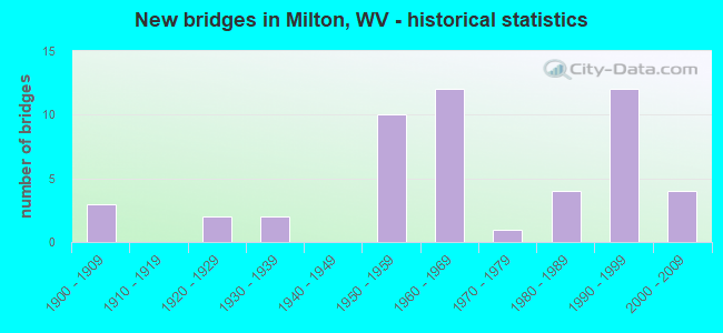
- New bridges - historical statistics
- 31900-1909
- 21920-1929
- 21930-1939
- 101950-1959
- 121960-1969
- 11970-1979
- 41980-1989
- 121990-1999
- 42000-2009

- Reconstructed bridges - Historical Statistics
- 21970-1979
- 01980-1989
- 71990-1999


- Bridge Condition - Deck
- 15.6%Good
- 56.3%Satisfactory
- 25.0%Fair
- 3.1%Poor

- Bridge Condition - Superstructure
- 25.0%Good
- 46.9%Satisfactory
- 25.0%Fair
- 3.1%Poor

- Bridge Condition - Substructure
- 15.6%Good
- 46.9%Satisfactory
- 34.4%Fair
- 3.1%Poor

- Bridge Condition - Channel
- 47.6%Good
- 42.9%Satisfactory
- 4.8%Fair
- 4.8%Poor

- Bridge Condition - Culverts
- 66.7%Satisfactory
- 33.3%Fair
Find on map >> Show street view
Structure Number: 6A236, Location: 0.44 MI. WEST OF CR 13 (Lat: 38.441622, Lng: -82.130056), Route carried "under" structure: County highway 1500, Year Built: 1959, Structure Length: 0. m, Average Daily Traffic: 1,700 (year 0006), Truck Traffic: 4%, Features Intersected: COUNTY ROUTE 15, Facility Carried by Structure: I64 WB
Minimum Vertical Clearance: 12.29m (40.32ft), Kilometerpoint: 0.097, Lanes on structure: 2, Lanes under structure: 2, Length of Maximum Span: 25.3m (83.0ft)
Find on map >> Show street view
Structure Number: 6A246, Location: 3.02 MI. EAST OF CR 60/89 (Lat: 38.430919, Lng: -82.203419), Route carried "under" structure: County highway 6029, Year Built: 1960, Structure Length: 0. m, Average Daily Traffic: 70 (year 0007), Features Intersected: COUNTY ROUTE 60/29, Facility Carried by Structure: I64 EB
Minimum Vertical Clearance: 4.22m (13.85ft), Kilometerpoint: 0.579, Lanes on structure: 2, Lanes under structure: 2, Length of Maximum Span: 14.6m (47.9ft)
Find on map >> Show street view
Structure Number: 6A247, Location: 3.02 MI. EAST OF CR 60/89 (Lat: 38.431119, Lng: -82.203489), Route carried "under" structure: County highway 6029, Year Built: 1960, Structure Length: 0. m, Average Daily Traffic: 70 (year 0007), Features Intersected: COUNTY ROUTE 60/29, Facility Carried by Structure: I64 WB
Minimum Vertical Clearance: 4.22m (13.85ft), Kilometerpoint: 0.579, Lanes on structure: 2, Lanes under structure: 2, Length of Maximum Span: 14.6m (47.9ft)
Find on map >> Show street view
Structure Number: 6A248, Location: 3.23 MI. WEST OF CR 13 (Lat: 38.432511, Lng: -82.186931), Route carried "under" structure: County highway 2300, Year Built: 1998, Structure Length: 0. m, Average Daily Traffic: 900 (year 0007), Truck Traffic: 4%, Features Intersected: County Route 23, Facility Carried by Structure: I-64 EB
Minimum Vertical Clearance: 13.16m (43.18ft), Kilometerpoint: 0.579, Lanes on structure: 2, Lanes under structure: 2, Length of Maximum Span: 27.4m (89.9ft)
Find on map >> Show street view
Structure Number: 6A249, Location: 3.23 MI. WEST OF CR 13 (Lat: 38.432689, Lng: -82.186939), Route carried "under" structure: County highway 2300, Year Built: 1998, Structure Length: 0. m, Average Daily Traffic: 900 (year 0007), Truck Traffic: 4%, Features Intersected: county route 23, Facility Carried by Structure: I-64 WB
Minimum Vertical Clearance: 13.16m (43.18ft), Kilometerpoint: 0.579, Lanes on structure: 2, Lanes under structure: 2, Length of Maximum Span: 27.4m (89.9ft)
Find on map >> Show street view
Structure Number: 6A288, Location: 0.44 MILES EAST OF C R 13 (Lat: 38.439361, Lng: -82.122589), Route carried "under" structure: County highway 1300, Year Built: 2008, Structure Length: 0. m, Average Daily Traffic: 12,500 (year 0007), Truck Traffic: 4%, Features Intersected: County Route 13, Facility Carried by Structure: INTERSTATE 64
Minimum Vertical Clearance: 4.80m (15.75ft), Kilometerpoint: 0.595, Lanes on structure: 4, Lanes under structure: 2, Length of Maximum Span: 31.4m (103.0ft)