Bridge Statistics for Monroe, Georgia (GA)
Condition, Traffic, Stress, Structural Evaluation, Project Costs
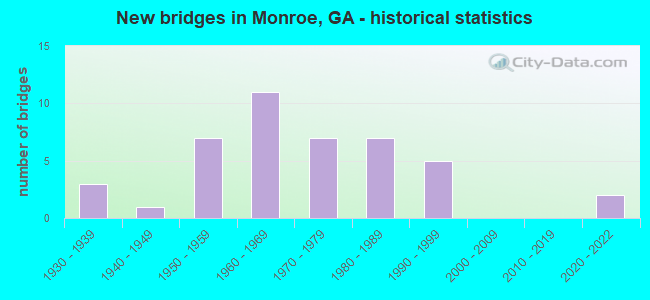
- New bridges - historical statistics
- 31930-1939
- 11940-1949
- 71950-1959
- 111960-1969
- 71970-1979
- 71980-1989
- 51990-1999
- 22020-2022


- Bridge Condition - Deck
- 11.8%Very good
- 58.8%Good
- 29.4%Satisfactory

- Bridge Condition - Superstructure
- 17.6%Very good
- 58.8%Good
- 11.8%Satisfactory
- 11.8%Fair

- Bridge Condition - Substructure
- 11.8%Very good
- 47.1%Good
- 29.4%Satisfactory
- 5.9%Fair
- 5.9%Serious

- Bridge Condition - Channel
- 20.0%Very good
- 17.1%Good
- 54.3%Satisfactory
- 8.6%Fair

- Bridge Condition - Culverts
- 61.5%Good
- 30.8%Satisfactory
- 7.7%Fair
Find on map >> Show street view
Structure Number: 2970009, Location: IN WEST MONROE (Lat: 33.801989, Lng: -83.736989), Route carried "under" structure: State highway 138, Structure Length: 0. m, Average Daily Traffic: 6,660 (year 2009), Truck Traffic: 1%, Features Intersected: SR 10 EBL (US 78), Facility Carried by Structure: US 78 EBL / SR 10
Minimum Vertical Clearance: 5.25m (17.22ft), Kilometerpoint: 16.093, Lanes on structure: 2, Length of Maximum Span: 0.0m
Find on map >> Show street view
Structure Number: 297001, Location: IN WEST MONROE (Lat: 33.802169, Lng: -83.736850), Route carried "under" structure: State highway 138, Structure Length: 0. m, Average Daily Traffic: 6,660 (year 2007), Truck Traffic: 1%, Features Intersected: SR 10 WBL (US 78), Facility Carried by Structure: US 78 WBL / SR 10
Minimum Vertical Clearance: 5.00m (16.40ft), Kilometerpoint: 16.093, Lanes on structure: 2, Length of Maximum Span: 0.0m
Find on map >> Show street view
Structure Number: 2970011, Location: IN NORTH MONROE (Lat: 33.805428, Lng: -83.709319), Route carried "under" structure: City street 3301, Structure Length: 0. m, Average Daily Traffic: 4,720 (year 2007), Truck Traffic: 1%, Features Intersected: SR 10 EBL (US 78), Facility Carried by Structure: US 78 EBL / SR 10
Minimum Vertical Clearance: 5.05m (16.57ft), Kilometerpoint: 0.000, Lanes on structure: 2, Length of Maximum Span: 0.0m
Find on map >> Show street view
Structure Number: 2970012, Location: IN NORTH MONROE (Lat: 33.805589, Lng: -83.709169), Route carried "under" structure: City street 3301, Structure Length: 0. m, Average Daily Traffic: 4,720 (year 2007), Truck Traffic: 1%, Features Intersected: SR 10 WBL (US 78), Facility Carried by Structure: US 78 WBL / SR 10
Minimum Vertical Clearance: 5.86m (19.23ft), Kilometerpoint: 1.609, Lanes on structure: 2, Length of Maximum Span: 0.0m
Find on map >> Show street view
Structure Number: 2970013, Location: IN NW MONROE (Lat: 33.804208, Lng: -83.696847), Route carried "under" structure: Business State highway 10, Structure Length: 0. m, Average Daily Traffic: 9,739 (year 2010), Truck Traffic: 2%, Features Intersected: SR 10 EBL (US 78)
Minimum Vertical Clearance: 5.89m (19.32ft), Kilometerpoint: 6.437, Lanes on structure: 2, Length of Maximum Span: 0.0m
Find on map >> Show street view
Structure Number: 2970014, Location: IN NW MONROE (Lat: 33.804408, Lng: -83.696747), Route carried "under" structure: Business State highway 10, Structure Length: 0. m, Average Daily Traffic: 6,730 (year 2007), Truck Traffic: 2%, Features Intersected: SR 10 WBL (US 78)
Minimum Vertical Clearance: 5.13m (16.83ft), Kilometerpoint: 6.437, Lanes on structure: 2, Length of Maximum Span: 0.0m
Find on map >> Show street view
Structure Number: 2970017, Location: 1 MI NW OF MONROE (Lat: 33.806239, Lng: -83.722528), Route carried "under" structure: US 78, Structure Length: 0. m, Average Daily Traffic: 12,800 (year 2007), Truck Traffic: 12%, Features Intersected: SR 11, Facility Carried by Structure: SR 11
Minimum Vertical Clearance: 5.38m (17.65ft), Kilometerpoint: 17.703, Lanes on structure: 4, Length of Maximum Span: 0.0m