Bridge Statistics for Monroeville, Pennsylvania (PA)
Condition, Traffic, Stress, Structural Evaluation, Project Costs
- National Bridge Inventory (NBI) Statistics
- 68Number of bridges
- 640ft / 195mTotal length
- $23,388,000Total costs
- 1,452,080Total average daily traffic
- 136,581Total average daily truck traffic
- National Bridge Inventory (NBI) Registered Bridges for Monroeville
- No street view available for this location
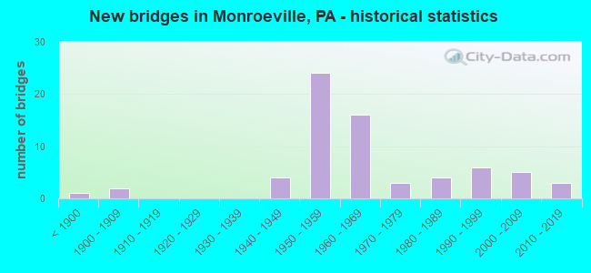
- New bridges - historical statistics
- 1Before 1900
- 21900-1909
- 41940-1949
- 241950-1959
- 161960-1969
- 31970-1979
- 41980-1989
- 61990-1999
- 52000-2009
- 32010-2019

- Reconstructed bridges - Historical Statistics
- 11920-1929
- 01930-1939
- 01940-1949
- 01950-1959
- 01960-1969
- 31970-1979
- 101980-1989
- 01990-1999
- 42000-2009
- 42010-2019


- Bridge Condition - Deck
- 6.5%Very good
- 38.7%Good
- 35.5%Satisfactory
- 3.2%Fair
- 12.9%Poor
- 3.2%Serious

- Bridge Condition - Superstructure
- 6.5%Very good
- 29.0%Good
- 32.3%Satisfactory
- 25.8%Fair
- 3.2%Serious
- 3.2%Imminent failure

- Bridge Condition - Substructure
- 6.5%Very good
- 32.3%Good
- 35.5%Satisfactory
- 22.6%Fair
- 3.2%Critical

- Bridge Condition - Channel
- 18.2%Good
- 31.8%Satisfactory
- 31.8%Fair
- 18.2%Poor

- Bridge Condition - Culverts
- 25.0%Good
- 50.0%Satisfactory
- 25.0%Fair
Find on map >> Show street view
Structure Number: 46974, Location: NEAR TURNPIKE INT. (Lat: 40.438889, Lng: -79.758139), Route carried "on" structure: Interstate 376, Year Built: 2011, Status: Open, Structure Length: 8.26m (27.10ft), Average Daily Traffic: 48,654 (year 2022), Truck Traffic: 8%, Average Future Daily Traffic: 50,000 (year 2037), Design Load: HL 93, Features Intersected: BUSINESS RT. 22
Minimum Vertical Clearance: 30+ m (98+ ft), Kilometerpoint: 56.021, Lanes on structure: 3, Lanes under structure: 5, Base Highway Network: Yes, Owner: State Highway Agency, Approaching Roadway Width: 17.7m (58.1ft), Skew: 4 degrees, Material/Design: Steel continuous, Design/Construction: Stringer/Multi-beam, Number Of Spans In Main Unit: 3, Length of Maximum Span: 44.8m (147.0ft), Curb-To-Curb Width: 16.5m (54.1ft), Out-to-Out Width: 17.5m (57.4ft)
Condition: Deck: Very good, Superstructure: Very good, Substructure: Very good, Operating Rating: 61.9 metric tons, Method Used To Determine Operating Rating: Assigned ratings based on Load and Resistance Factor Design (LRFD) reported by rating factor (RF) using HL93 loadings, Inventory Rating: 45.7 metric tons, Method Used To Determine Inventory Rating: Assigned ratings based on Load and Resistance Factor Design (LRFD) reported by rating factor (RF) using HL93 loadings, Structural Evaluation: Equal to present desirable criteria, Deck Geometry: Equal to present minimum criteria, Underclear: Meets minimum limits, Approach Roadway Alignment: Equal to present desirable criteria, Designated Inspection Frequency: Every 24 months, Inspection Date: July 2021, Deck Structure Type: Concrete Cast-file-Place, Wearing Surface/Protective System: Wearing Surface: Monolithic Concrete, Deck Protection: Epoxy Coated Reinforcing
Find on map >> Show street view
Structure Number: 49126, Location: 200' S Old Frankstown Rd. (Lat: 40.445425, Lng: -79.714467), Route carried "on" structure: City street , Year Built: 1995, Status: Open, Structure Length: 0.61m (2.00ft), Average Daily Traffic: 250 (year 2017), Truck Traffic: 1%, Average Future Daily Traffic: 300 (year 2037), Design Load: HS 20, Features Intersected: Pierson Run, Facility Carried by Structure: Old Abers Creek Rd
Minimum Vertical Clearance: 30+ m (98+ ft), Kilometerpoint: 0.000, Lanes on structure: 2, Owner: City or Municipal Highway Agency, Approaching Roadway Width: 7.0m (23.0ft), Material/Design: Steel, Design/Construction: Culvert, Number Of Spans In Main Unit: 1, Length of Maximum Span: 6.1m (20.0ft)
Condition: Channel: Fair, Culverts: Fair, Operating Rating: 50.8 metric tons, Method Used To Determine Operating Rating: Field evaluation and documented engineering judgment, Inventory Rating: 30.8 metric tons, Method Used To Determine Inventory Rating: Field evaluation and documented engineering judgment, Structural Evaluation: Somewhat better than minimum adequacy, Waterway Adequacy: Better than present minimum criteria, Approach Roadway Alignment: Equal to present desirable criteria, Designated Inspection Frequency: Every 24 months, Inspection Date: May 2021
Find on map >> Show street view
Structure Number: 1099, Location: OVER SR 0022 (Lat: 40.425000, Lng: -79.733333), Route carried "under" structure: US 22, Year Built: 1950, Structure Length: 0. m, Average Daily Traffic: 14,002 (year 2020), Truck Traffic: 12%, Features Intersected: SR 0022, Facility Carried by Structure: GOLDEN MILE HW
Minimum Vertical Clearance: 4.42m (14.50ft), Kilometerpoint: 14.668, Lanes on structure: 1, Lanes under structure: 4, Material/Design: Steel, Design/Construction: Stringer/Multi-beam, Length of Maximum Span: 42.1m (138.1ft)
Find on map >> Show street view
Structure Number: 1099, Location: OVER SR 0022 (Lat: 40.425000, Lng: -79.733333), Route carried "under" structure: US 22, Year Built: 1950, Structure Length: 0. m, Average Daily Traffic: 15,231 (year 2020), Truck Traffic: 11%, Features Intersected: SR 0022, Facility Carried by Structure: GOLDEN MILE HW
Minimum Vertical Clearance: 5.16m (16.93ft), Kilometerpoint: 14.693, Lanes on structure: 1, Lanes under structure: 4, Material/Design: Steel, Design/Construction: Stringer/Multi-beam, Length of Maximum Span: 42.1m (138.1ft)
Find on map >> Show street view
Structure Number: 1204, Location: 2.5 MI W OF PA TURNPIKE (Lat: 40.441964, Lng: -79.797381), Route carried "under" structure: State highway , Year Built: 1962, Structure Length: 0. m, Average Daily Traffic: 4,977 (year 2022), Truck Traffic: 2%, Features Intersected: UNION RR,THOMPSON RUN, Facility Carried by Structure: I-376
Minimum Vertical Clearance: 30+ m (98+ ft), Kilometerpoint: 5.016, Lanes on structure: 6, Lanes under structure: 2, Material/Design: Steel continuous, Design/Construction: Girder and Floorbeam System, Length of Maximum Span: 52.4m (171.9ft)
Find on map >> Show street view
Structure Number: 1206, Location: I376 O/OLD WM.PENN HWY. (Lat: 40.443892, Lng: -79.778117), Route carried "under" structure: City street , Year Built: 1962, Structure Length: 0. m, Average Daily Traffic: 1,000 (year 1996), Truck Traffic: 1%, Features Intersected: OLD WM PENN HWY,LEAK RUN, Facility Carried by Structure: PARKWAY EAST
Minimum Vertical Clearance: 5.18m (16.99ft), Kilometerpoint: 0.000, Lanes on structure: 6, Lanes under structure: 2, Material/Design: Prestressed concrete, Design/Construction: Box Beam or Girders - Single/Spread, Length of Maximum Span: 21.0m (68.9ft)
Find on map >> Show street view
Structure Number: 1207, Location: GARDEN CITY DR.O/I376 (Lat: 40.444725, Lng: -79.773164), Route carried "under" structure: Interstate 376, Year Built: 1962, Structure Length: 0. m, Average Daily Traffic: 43,646 (year 2022), Truck Traffic: 8%, Features Intersected: OVER 376 EB WB, Facility Carried by Structure: GARDEN CITY DR
Minimum Vertical Clearance: 4.67m (15.32ft), Kilometerpoint: 54.343, Lanes on structure: 2, Lanes under structure: 6, Material/Design: Steel, Design/Construction: Stringer/Multi-beam, Length of Maximum Span: 34.1m (111.9ft)
Find on map >> Show street view
Structure Number: 1207, Location: GARDEN CITY DR.O/I376 (Lat: 40.444725, Lng: -79.773164), Route carried "under" structure: Interstate 376, Year Built: 1962, Structure Length: 0. m, Average Daily Traffic: 48,654 (year 2022), Truck Traffic: 8%, Features Intersected: OVER 376 EB WB, Facility Carried by Structure: GARDEN CITY DR
Minimum Vertical Clearance: 4.67m (15.32ft), Kilometerpoint: 54.412, Lanes on structure: 2, Lanes under structure: 6, Material/Design: Steel, Design/Construction: Stringer/Multi-beam, Length of Maximum Span: 34.1m (111.9ft)
Find on map >> Show street view
Structure Number: 1208, Location: OVER OLD WM.PENN HIGHWAY (Lat: 40.444306, Lng: -79.767939), Route carried "under" structure: County highway , Year Built: 1962, Structure Length: 0. m, Average Daily Traffic: 10,000 (year 2005), Truck Traffic: 3%, Features Intersected: OLD WILLIAM PENN HIGHWAY, Facility Carried by Structure: PARKWAY EAST HW
Minimum Vertical Clearance: 10.67m (35.01ft), Kilometerpoint: 0.000, Lanes on structure: 6, Lanes under structure: 2, Material/Design: Prestressed concrete, Design/Construction: Box Beam or Girders - Multiple, Length of Maximum Span: 25.9m (85.0ft)
Find on map >> Show street view
Structure Number: 1212, Location: I 376 E.B.OVER SR 2057 (Lat: 40.440525, Lng: -79.760494), Route carried "under" structure: State highway , Year Built: 1962, Structure Length: 0. m, Average Daily Traffic: 13,248 (year 2020), Truck Traffic: 6%, Features Intersected: HAYMAKER ROAD, Facility Carried by Structure: PARKWAY EAST
Minimum Vertical Clearance: 4.42m (14.50ft), Kilometerpoint: 0.000, Lanes on structure: 4, Lanes under structure: 4, Material/Design: Steel, Design/Construction: Stringer/Multi-beam, Length of Maximum Span: 34.4m (112.9ft)
Find on map >> Show street view
Structure Number: 1212, Location: I 376 E.B.OVER SR 2057 (Lat: 40.440525, Lng: -79.760494), Route carried "under" structure: State highway , Year Built: 1962, Structure Length: 0. m, Average Daily Traffic: 11,730 (year 2020), Truck Traffic: 8%, Features Intersected: HAYMAKER ROAD, Facility Carried by Structure: PARKWAY EAST
Minimum Vertical Clearance: 4.42m (14.50ft), Kilometerpoint: 0.000, Lanes on structure: 4, Lanes under structure: 4, Material/Design: Steel, Design/Construction: Stringer/Multi-beam, Length of Maximum Span: 34.4m (112.9ft)
Find on map >> Show street view
Structure Number: 1216, Location: I 376 W.B.OVER SR 2057 (Lat: 40.440914, Lng: -79.760481), Route carried "under" structure: State highway , Year Built: 1962, Structure Length: 0. m, Average Daily Traffic: 11,730 (year 2020), Truck Traffic: 8%, Features Intersected: HAYMAKER ROAD, Facility Carried by Structure: PARKWAY WEST
Minimum Vertical Clearance: 4.60m (15.09ft), Kilometerpoint: 0.000, Lanes on structure: 4, Lanes under structure: 4, Material/Design: Steel, Design/Construction: Stringer/Multi-beam, Length of Maximum Span: 30.8m (101.0ft)
Find on map >> Show street view
Structure Number: 1216, Location: I 376 W.B.OVER SR 2057 (Lat: 40.440914, Lng: -79.760481), Route carried "under" structure: State highway , Year Built: 1962, Structure Length: 0. m, Average Daily Traffic: 13,248 (year 2020), Truck Traffic: 6%, Features Intersected: HAYMAKER ROAD, Facility Carried by Structure: PARKWAY WEST
Minimum Vertical Clearance: 4.60m (15.09ft), Kilometerpoint: 0.000, Lanes on structure: 4, Lanes under structure: 4, Material/Design: Steel, Design/Construction: Stringer/Multi-beam, Length of Maximum Span: 30.8m (101.0ft)
Find on map >> Show street view
Structure Number: 1575, Location: HALL STATION BRIDGE (Lat: 40.430917, Lng: -79.804633), Route carried "under" structure: State highway , Year Built: 1942, Structure Length: 0. m, Average Daily Traffic: 778 (year 2022), Truck Traffic: 3%, Features Intersected: LR 744,UNION RR,THOMPSON, Facility Carried by Structure: WIlliam Penn Hwy
Minimum Vertical Clearance: 16.00m (52.49ft), Kilometerpoint: 3.819, Lanes on structure: 2, Lanes under structure: 2, Material/Design: Steel continuous, Design/Construction: Truss - Deck, Length of Maximum Span: 121.9m (399.9ft)
Find on map >> Show street view
Structure Number: 2099, Location: NEAR BOYCE PARK (Lat: 40.455000, Lng: -79.755000), Route carried "under" structure: Interstate 76, Year Built: 1952, Structure Length: 0. m, Average Daily Traffic: 38,689 (year 2004), Truck Traffic: 17%, Features Intersected: PA TPK (I-76), Facility Carried by Structure: MONROEVILLE ROAD
Minimum Vertical Clearance: 5.26m (17.26ft), Kilometerpoint: 0.000, Lanes on structure: 2, Lanes under structure: 4, Material/Design: Steel, Design/Construction: Stringer/Multi-beam, Length of Maximum Span: 36.6m (120.1ft)
Find on map >> Show street view
Structure Number: 21, Location: NEAR CCAC BOYCE CAMPUS (Lat: 40.451906, Lng: -79.754253), Route carried "under" structure: City street , Year Built: 1952, Structure Length: 0. m, Average Daily Traffic: 200 (year 1992), Features Intersected: BEATTY ROAD, Facility Carried by Structure: PA TPK (I-76)
Minimum Vertical Clearance: 4.52m (14.83ft), Kilometerpoint: 0.000, Lanes on structure: 4, Lanes under structure: 2, Toll: On toll road, Material/Design: Steel, Design/Construction: Stringer/Multi-beam, Length of Maximum Span: 25.0m (82.0ft)
Find on map >> Show street view
Structure Number: 2101, Location: WEST OF PITTSBURGH INTG (Lat: 40.438333, Lng: -79.751667), Route carried "under" structure: City street , Year Built: 1952, Structure Length: 0. m, Average Daily Traffic: 200 (year 0000), Features Intersected: T-911, Facility Carried by Structure: PA TPK (I-76)
Minimum Vertical Clearance: 4.38m (14.37ft), Kilometerpoint: 0.000, Lanes on structure: 4, Lanes under structure: 2, Toll: On toll road, Material/Design: Steel, Design/Construction: Stringer/Multi-beam, Length of Maximum Span: 8.2m (26.9ft)
Find on map >> Show street view
Structure Number: 2102, Location: TURNPK RMP.EH O/ SR2048 (Lat: 40.436667, Lng: -79.755000), Route carried "under" structure: Business US 22B, Year Built: 1999, Structure Length: 0. m, Average Daily Traffic: 16,890 (year 2022), Truck Traffic: 5%, Features Intersected: SR2048 & I-376RP, Facility Carried by Structure: RAMP E&H
Minimum Vertical Clearance: 4.60m (15.09ft), Kilometerpoint: 7.530, Lanes on structure: 3, Lanes under structure: 1, Material/Design: Steel continuous, Design/Construction: Stringer/Multi-beam, Length of Maximum Span: 37.2m (122.0ft)
Find on map >> Show street view
Structure Number: 2102, Location: TURNPK RMP.EH O/ SR2048 (Lat: 40.436667, Lng: -79.755000), Route carried "under" structure: Business US 22B, Year Built: 1999, Structure Length: 0. m, Average Daily Traffic: 15,934 (year 2022), Truck Traffic: 5%, Features Intersected: SR2048 & I-376RP, Facility Carried by Structure: RAMP E&H
Minimum Vertical Clearance: 5.16m (16.93ft), Kilometerpoint: 7.339, Lanes on structure: 3, Lanes under structure: 3, Material/Design: Steel continuous, Design/Construction: Stringer/Multi-beam, Length of Maximum Span: 37.2m (122.0ft)
Find on map >> Show street view
Structure Number: 2104, Location: WEST OF PITTSBURGH INTG (Lat: 40.438533, Lng: -79.750753), Route carried "under" structure: Interstate 376, Year Built: 1952, Structure Length: 0. m, Average Daily Traffic: 48,654 (year 2022), Truck Traffic: 8%, Features Intersected: SR 0022, LR187, Facility Carried by Structure: PA TPK (I-76)
Minimum Vertical Clearance: 30+ m (98+ ft), Kilometerpoint: 56.826, Lanes on structure: 4, Lanes under structure: 4, Material/Design: Steel continuous, Design/Construction: Stringer/Multi-beam, Length of Maximum Span: 26.2m (86.0ft)
Find on map >> Show street view
Structure Number: 2104, Location: WEST OF PITTSBURGH INTG (Lat: 40.438533, Lng: -79.750753), Route carried "under" structure: US 22, Year Built: 1952, Structure Length: 0. m, Average Daily Traffic: 26,807 (year 2022), Truck Traffic: 7%, Features Intersected: SR 0022, LR187, Facility Carried by Structure: PA TPK (I-76)
Minimum Vertical Clearance: 6.52m (21.39ft), Kilometerpoint: 11.771, Lanes on structure: 4, Lanes under structure: 4, Material/Design: Steel continuous, Design/Construction: Stringer/Multi-beam, Length of Maximum Span: 26.2m (86.0ft)
Find on map >> Show street view
Structure Number: 2104, Location: WEST OF PITTSBURGH INTG (Lat: 40.438533, Lng: -79.750753), Route carried "under" structure: US 22, Year Built: 1952, Structure Length: 0. m, Average Daily Traffic: 26,459 (year 2022), Truck Traffic: 7%, Features Intersected: SR 0022, LR187, Facility Carried by Structure: PA TPK (I-76)
Minimum Vertical Clearance: 6.58m (21.59ft), Kilometerpoint: 11.771, Lanes on structure: 4, Lanes under structure: 4, Material/Design: Steel continuous, Design/Construction: Stringer/Multi-beam, Length of Maximum Span: 26.2m (86.0ft)
Find on map >> Show street view
Structure Number: 2105, Location: PITTSBURGH INTERCHANGE (Lat: 40.360000, Lng: -79.831667), Route carried "under" structure: Interstate 76, Year Built: 1952, Structure Length: 0. m, Average Daily Traffic: 38,689 (year 2004), Truck Traffic: 17%, Features Intersected: PA TPK (I-76), Facility Carried by Structure: PA TPK RAMPS B&C
Minimum Vertical Clearance: 4.44m (14.57ft), Kilometerpoint: 0.000, Lanes on structure: 3, Lanes under structure: 4, Toll: On toll road, Material/Design: Steel, Design/Construction: Girder and Floorbeam System, Length of Maximum Span: 28.3m (92.8ft)
Find on map >> Show street view
Structure Number: 2106, Location: NEAR PITTSBURGH INTERCHG (Lat: 40.434306, Lng: -79.748142), Route carried "under" structure: Interstate 76, Year Built: 1952, Structure Length: 0. m, Average Daily Traffic: 38,689 (year 2004), Truck Traffic: 17%, Features Intersected: PA TPK (I-76)
Minimum Vertical Clearance: 4.56m (14.96ft), Kilometerpoint: 0.000, Lanes on structure: 2, Lanes under structure: 4, Material/Design: Steel, Design/Construction: Girder and Floorbeam System, Length of Maximum Span: 40.2m (131.9ft)
Find on map >> Show street view
Structure Number: 2108, Location: NEAR ALLEGH-WESTMLD CO LN (Lat: 40.741667, Lng: -79.730000), Route carried "under" structure: City street , Year Built: 1952, Structure Length: 0. m, Average Daily Traffic: 200 (year 1992), Features Intersected: T-423, Abers Creek Road, Facility Carried by Structure: PA TPK (I-76)
Minimum Vertical Clearance: 4.48m (14.70ft), Kilometerpoint: 0.000, Lanes on structure: 4, Lanes under structure: 2, Material/Design: Concrete, Design/Construction: Culvert, Length of Maximum Span: 6.1m (20.0ft)
Find on map >> Show street view
Structure Number: 2896, Location: MONROEVILLE MALL OVERPASS (Lat: 40.433378, Lng: -79.794264), Route carried "under" structure: Business US 22B, Year Built: 1970, Structure Length: 0. m, Average Daily Traffic: 13,204 (year 2022), Truck Traffic: 1%, Features Intersected: BUSINESS 22, Facility Carried by Structure: MALL ENTRANCE
Minimum Vertical Clearance: 4.32m (14.17ft), Kilometerpoint: 3.957, Lanes on structure: 2, Lanes under structure: 5, Material/Design: Steel, Design/Construction: Stringer/Multi-beam, Length of Maximum Span: 33.2m (108.9ft)
Find on map >> Show street view
Structure Number: 2896, Location: MONROEVILLE MALL OVERPASS (Lat: 40.433378, Lng: -79.794264), Route carried "under" structure: Business US 22B, Year Built: 1970, Structure Length: 0. m, Average Daily Traffic: 18,535 (year 2021), Truck Traffic: 3%, Features Intersected: BUSINESS 22, Facility Carried by Structure: MALL ENTRANCE
Minimum Vertical Clearance: 4.37m (14.34ft), Kilometerpoint: 3.816, Lanes on structure: 2, Lanes under structure: 5, Material/Design: Steel, Design/Construction: Stringer/Multi-beam, Length of Maximum Span: 33.2m (108.9ft)
Find on map >> Show street view
Structure Number: 44347, Location: 150'N.OF MONROEVILLE BLVD (Lat: 40.437056, Lng: -79.779983), Route carried "under" structure: Business US 22B, Year Built: 2007, Structure Length: 0. m, Average Daily Traffic: 13,204 (year 2022), Truck Traffic: 1%, Features Intersected: SR 2048 (BUSINESS RT. 22, Facility Carried by Structure: OLD NORTHERN PIKE
Minimum Vertical Clearance: 5.36m (17.59ft), Kilometerpoint: 5.403, Lanes on structure: 2, Lanes under structure: 2, Material/Design: Prestressed concrete, Design/Construction: Stringer/Multi-beam, Length of Maximum Span: 32.6m (107.0ft)
Find on map >> Show street view
Structure Number: 44347, Location: 150'N.OF MONROEVILLE BLVD (Lat: 40.437056, Lng: -79.779983), Route carried "under" structure: Business US 22B, Year Built: 2007, Structure Length: 0. m, Average Daily Traffic: 11,805 (year 2022), Truck Traffic: 1%, Features Intersected: SR 2048 (BUSINESS RT. 22, Facility Carried by Structure: OLD NORTHERN PIKE
Minimum Vertical Clearance: 5.36m (17.59ft), Kilometerpoint: 5.256, Lanes on structure: 2, Lanes under structure: 2, Material/Design: Prestressed concrete, Design/Construction: Stringer/Multi-beam, Length of Maximum Span: 32.6m (107.0ft)
Find on map >> Show street view
Structure Number: 46974, Location: NEAR TURNPIKE INT. (Lat: 40.438889, Lng: -79.758139), Route carried "under" structure: US 22B, Year Built: 2011, Structure Length: 0. m, Average Daily Traffic: 16,890 (year 2022), Truck Traffic: 5%, Features Intersected: BUSINESS RT. 22, Facility Carried by Structure: INTERSTATE 376
Minimum Vertical Clearance: 5.03m (16.50ft), Kilometerpoint: 7.067, Lanes on structure: 3, Lanes under structure: 2, Material/Design: Steel continuous, Design/Construction: Stringer/Multi-beam, Length of Maximum Span: 44.8m (147.0ft)
Find on map >> Show street view
Structure Number: 46974, Location: NEAR TURNPIKE INT. (Lat: 40.438889, Lng: -79.758139), Route carried "under" structure: US 22B, Year Built: 2011, Structure Length: 0. m, Average Daily Traffic: 15,934 (year 2022), Truck Traffic: 5%, Features Intersected: BUSINESS RT. 22, Facility Carried by Structure: INTERSTATE 376
Minimum Vertical Clearance: 5.33m (17.49ft), Kilometerpoint: 6.925, Lanes on structure: 3, Lanes under structure: 3, Material/Design: Steel continuous, Design/Construction: Stringer/Multi-beam, Length of Maximum Span: 44.8m (147.0ft)