Bridge Statistics for Monterey Park, California (CA)
Condition, Traffic, Stress, Structural Evaluation, Project Costs
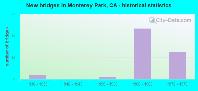
- New bridges - historical statistics
- 41930-1939
- 21950-1959
- 471960-1969
- 251970-1979

- Reconstructed bridges - Historical Statistics
- 21960-1969
- 01970-1979
- 01980-1989
- 51990-1999


- Bridge Condition - Deck
- 64.3%Good
- 7.1%Satisfactory
- 28.6%Fair

- Bridge Condition - Superstructure
- 82.1%Good
- 3.6%Satisfactory
- 14.3%Fair

- Bridge Condition - Substructure
- 89.3%Good
- 3.6%Satisfactory
- 7.1%Fair

- Bridge Condition - Channel
- 83.3%Very good
- 16.7%Fair

- Bridge Condition - Culverts
- 75.0%Good
- 25.0%Satisfactory
Find on map >> Show street view
Structure Number: 53 1447G, Location: 07-LA-710-T31.40-MONP (Lat: 34.059472, Lng: -118.165011), Route carried "under" structure: State highway 710, Year Built: 1960, Structure Length: 0. m, Average Daily Traffic: 50,000 (year 2015), Truck Traffic: 5%, Features Intersected: I 710, I 10,CONNS,RAMONA
Minimum Vertical Clearance: 4.92m (16.14ft), Kilometerpoint: 31.400, Lanes on structure: 3, Lanes under structure: 5, Material/Design: Concrete continuous, Design/Construction: Box Beam or Girders - Multiple, Length of Maximum Span: 31.7m (104.0ft)
Find on map >> Show street view
Structure Number: 53 1447G, Location: 07-LA-710-T31.40-MONP (Lat: 34.059472, Lng: -118.165011), Route carried "under" structure: Ramp Interstate 10, Year Built: 1960, Structure Length: 0. m, Average Daily Traffic: 25,000 (year 2009), Truck Traffic: 1%, Features Intersected: I 710, I 10,CONNS,RAMONA
Minimum Vertical Clearance: 4.92m (16.14ft), Kilometerpoint: 21.480, Lanes on structure: 3, Lanes under structure: 2, Material/Design: Concrete continuous, Design/Construction: Box Beam or Girders - Multiple, Length of Maximum Span: 31.7m (104.0ft)
Find on map >> Show street view
Structure Number: 53 1459G, Location: 07-LA-010-21.33-MONP (Lat: 34.060069, Lng: -118.165831), Route carried "under" structure: City street , Year Built: 1960, Structure Length: 0. m, Average Daily Traffic: 11,200 (year 2005), Truck Traffic: 10%, Features Intersected: RAMONA BLVD, Facility Carried by Structure: E10-S710 CONNECTOR
Minimum Vertical Clearance: 4.65m (15.26ft), Kilometerpoint: 0.000, Lanes on structure: 2, Lanes under structure: 4, Material/Design: Concrete continuous, Design/Construction: Box Beam or Girders - Multiple, Length of Maximum Span: 18.9m (62.0ft)
Find on map >> Show street view
Structure Number: 53 1459L, Location: 07-LA-710-26.38-MONP (Lat: 34.059522, Lng: -118.165486), Route carried "under" structure: City street L360, Year Built: 1960, Structure Length: 0. m, Average Daily Traffic: 12,800 (year 2010), Truck Traffic: 10%, Features Intersected: RAMONA BLVD, Facility Carried by Structure: ROUTE 710 SB
Minimum Vertical Clearance: 7.92m (25.98ft), Kilometerpoint: 0.000, Lanes on structure: 3, Lanes under structure: 4, Material/Design: Concrete continuous, Design/Construction: Box Beam or Girders - Multiple, Length of Maximum Span: 21.9m (71.9ft)
Find on map >> Show street view
Structure Number: 53 1459R, Location: 07-LA-710-26.38-MONP (Lat: 34.059469, Lng: -118.165244), Route carried "under" structure: City street L360, Year Built: 1960, Structure Length: 0. m, Average Daily Traffic: 12,800 (year 2010), Truck Traffic: 10%, Features Intersected: RAMONA BLVD, Facility Carried by Structure: ROUTE 710 NB
Minimum Vertical Clearance: 6.60m (21.65ft), Kilometerpoint: 0.000, Lanes on structure: 2, Lanes under structure: 4, Material/Design: Concrete continuous, Design/Construction: Box Beam or Girders - Multiple, Length of Maximum Span: 21.9m (71.9ft)
Find on map >> Show street view
Structure Number: 53 1489, Location: 07-LA-710-R26.59-MONP (Lat: 34.062522, Lng: -118.164658), Route carried "under" structure: State highway 710, Year Built: 1974, Structure Length: 0. m, Average Daily Traffic: 45,500 (year 2017), Truck Traffic: 5%, Features Intersected: INTERSTATE 710, Facility Carried by Structure: BNSF, SCRRA METRO
Minimum Vertical Clearance: 5.31m (17.42ft), Kilometerpoint: 26.590, Lanes under structure: 5, Material/Design: Prestressed concrete continuous, Length of Maximum Span: 27.7m (90.9ft)
Find on map >> Show street view
Structure Number: 53 1489, Location: 07-LA-710-R26.59-MONP (Lat: 34.062522, Lng: -118.164658), Route carried "under" structure: Ramp State highway 710, Year Built: 1974, Structure Length: 0. m, Average Daily Traffic: 400 (year 2009), Truck Traffic: 1%, Features Intersected: INTERSTATE 710, Facility Carried by Structure: BNSF, SCRRA METRO
Minimum Vertical Clearance: 5.38m (17.65ft), Kilometerpoint: 26.590, Lanes under structure: 1, Material/Design: Prestressed concrete continuous, Length of Maximum Span: 27.7m (90.9ft)
Find on map >> Show street view
Structure Number: 53 1697, Location: 07-LA-060-R4.43-MONP (Lat: 34.035200, Lng: -118.150439), Route carried "under" structure: City street L062, Year Built: 1967, Structure Length: 0. m, Average Daily Traffic: 41,746 (year 2019), Truck Traffic: 2%, Features Intersected: ATLANTIC BLVD, Facility Carried by Structure: STATE ROUTE 60
Minimum Vertical Clearance: 5.05m (16.57ft), Kilometerpoint: 0.000, Lanes on structure: 12, Lanes under structure: 6, Material/Design: Concrete continuous, Design/Construction: Box Beam or Girders - Multiple, Length of Maximum Span: 17.1m (56.1ft)
Find on map >> Show street view
Structure Number: 53 1699, Location: 07-LA-060-R4.68-MONP (Lat: 34.033522, Lng: -118.147047), Route carried "under" structure: County highway L700, Year Built: 1967, Structure Length: 0. m, Average Daily Traffic: 5,448 (year 2019), Truck Traffic: 2%, Features Intersected: POMONA BLVD, Facility Carried by Structure: STATE ROUTE 60
Minimum Vertical Clearance: 4.57m (14.99ft), Kilometerpoint: 0.000, Lanes on structure: 12, Lanes under structure: 2, Material/Design: Concrete, Design/Construction: Box Beam or Girders - Single/Spread, Length of Maximum Span: 33.2m (108.9ft)
Find on map >> Show street view
Structure Number: 53 1702, Location: 07-LA-710-R26.59-MONP (Lat: 34.062625, Lng: -118.166028), Route carried "under" structure: Ramp State highway 710, Year Built: 1974, Structure Length: 0. m, Average Daily Traffic: 60,000 (year 2009), Truck Traffic: 5%, Features Intersected: S710-W10 CONNECTOR RAMP, Facility Carried by Structure: BNSF, SCRRA METRO
Minimum Vertical Clearance: 5.33m (17.49ft), Kilometerpoint: 26.590, Lanes under structure: 1, Material/Design: Prestressed concrete, Design/Construction: Slab, Length of Maximum Span: 14.6m (47.9ft)
Find on map >> Show street view
Structure Number: 53 1729, Location: 07-LA-060-R4.08-MONP (Lat: 34.036394, Lng: -118.156033), Route carried "under" structure: City street , Year Built: 1967, Structure Length: 0. m, Average Daily Traffic: 5,800 (year 2019), Truck Traffic: 2%, Features Intersected: WOODS AVENUE, Facility Carried by Structure: STATE ROUTE 60
Minimum Vertical Clearance: 4.82m (15.81ft), Kilometerpoint: 0.000, Lanes on structure: 12, Lanes under structure: 2, Material/Design: Concrete continuous, Design/Construction: Box Beam or Girders - Multiple, Length of Maximum Span: 18.9m (62.0ft)
Find on map >> Show street view
Structure Number: 53 1774, Location: 07-LA-060-R6.86-MONP (Lat: 34.034344, Lng: -118.108617), Route carried "under" structure: State highway 60, Year Built: 1967, Structure Length: 0. m, Average Daily Traffic: 232,000 (year 2019), Truck Traffic: 20%, Features Intersected: STATE ROUTE 60, Facility Carried by Structure: GREENWOOD AVE
Minimum Vertical Clearance: 4.95m (16.24ft), Kilometerpoint: 6.860, Lanes on structure: 2, Lanes under structure: 10, Material/Design: Concrete continuous, Design/Construction: Box Beam or Girders - Multiple, Length of Maximum Span: 33.5m (109.9ft)
Find on map >> Show street view
Structure Number: 53 2054, Location: 07-LA-010-21.00-MONP (Lat: 34.061017, Lng: -118.170861), Route carried "under" structure: Interstate 10, Year Built: 1972, Structure Length: 0. m, Average Daily Traffic: 96,000 (year 2009), Truck Traffic: 3%, Features Intersected: I 10,CONN,RMPS,METRO,BUS, Facility Carried by Structure: CAMPUS ROAD
Minimum Vertical Clearance: 7.29m (23.92ft), Kilometerpoint: 21.000, Lanes on structure: 5, Lanes under structure: 9, Material/Design: Concrete continuous, Design/Construction: Box Beam or Girders - Multiple, Length of Maximum Span: 41.3m (135.5ft)
Find on map >> Show street view
Structure Number: 53 2054, Location: 07-LA-010-21.00-MONP (Lat: 34.061017, Lng: -118.170861), Route carried "under" structure: Ramp Interstate 10, Year Built: 1972, Structure Length: 0. m, Average Daily Traffic: 4,300 (year 2005), Truck Traffic: 2%, Features Intersected: I 10,CONN,RMPS,METRO,BUS, Facility Carried by Structure: CAMPUS ROAD
Minimum Vertical Clearance: 6.43m (21.10ft), Kilometerpoint: 21.040, Lanes on structure: 5, Lanes under structure: 2, Material/Design: Concrete continuous, Design/Construction: Box Beam or Girders - Multiple, Length of Maximum Span: 41.3m (135.5ft)
Find on map >> Show street view
Structure Number: 53 2054, Location: 07-LA-010-21.00-MONP (Lat: 34.061017, Lng: -118.170861), Route carried "under" structure: Ramp Interstate 10, Year Built: 1972, Structure Length: 0. m, Average Daily Traffic: 28,600 (year 2005), Truck Traffic: 5%, Features Intersected: I 10,CONN,RMPS,METRO,BUS, Facility Carried by Structure: CAMPUS ROAD
Minimum Vertical Clearance: 5.08m (16.67ft), Kilometerpoint: 21.000, Lanes on structure: 5, Lanes under structure: 3, Material/Design: Concrete continuous, Design/Construction: Box Beam or Girders - Multiple, Length of Maximum Span: 41.3m (135.5ft)
Find on map >> Show street view
Structure Number: 53 2054, Location: 07-LA-010-21.00-MONP (Lat: 34.061017, Lng: -118.170861), Route carried "under" structure: Ramp Interstate 710, Year Built: 1972, Structure Length: 0. m, Average Daily Traffic: 23,800 (year 2005), Truck Traffic: 5%, Features Intersected: I 10,CONN,RMPS,METRO,BUS, Facility Carried by Structure: CAMPUS ROAD
Minimum Vertical Clearance: 5.66m (18.57ft), Kilometerpoint: 26.460, Lanes on structure: 5, Lanes under structure: 3, Material/Design: Concrete continuous, Design/Construction: Box Beam or Girders - Multiple, Length of Maximum Span: 41.3m (135.5ft)
Find on map >> Show street view
Structure Number: 53 2054, Location: 07-LA-010-21.00-MONP (Lat: 34.061017, Lng: -118.170861), Route carried "under" structure: Interstate 10, Year Built: 1972, Structure Length: 0. m, Average Daily Traffic: 6,800 (year 2005), Truck Traffic: 1%, Features Intersected: I 10,CONN,RMPS,METRO,BUS, Facility Carried by Structure: CAMPUS ROAD
Minimum Vertical Clearance: 6.17m (20.24ft), Kilometerpoint: 20.000, Lanes on structure: 5, Lanes under structure: 1, Material/Design: Concrete continuous, Design/Construction: Box Beam or Girders - Multiple, Length of Maximum Span: 41.3m (135.5ft)
Find on map >> Show street view
Structure Number: 53 2054, Location: 07-LA-010-21.00-MONP (Lat: 34.061017, Lng: -118.170861), Route carried "under" structure: Interstate 10, Year Built: 1972, Structure Length: 0. m, Average Daily Traffic: 6,800 (year 2005), Truck Traffic: 1%, Features Intersected: I 10,CONN,RMPS,METRO,BUS, Facility Carried by Structure: CAMPUS ROAD
Minimum Vertical Clearance: 4.93m (16.17ft), Kilometerpoint: 20.000, Lanes on structure: 5, Lanes under structure: 1, Material/Design: Concrete continuous, Design/Construction: Box Beam or Girders - Multiple, Length of Maximum Span: 41.3m (135.5ft)
Find on map >> Show street view
Structure Number: 53 2505L, Location: 07-LA-010S-21.35-MONP (Lat: 34.062631, Lng: -118.166044), Route carried "under" structure: Ramp Interstate 710, Year Built: 1974, Structure Length: 0. m, Average Daily Traffic: 4,050 (year 2012), Truck Traffic: 3%, Features Intersected: I 710 & S710-W10 CONN, Facility Carried by Structure: W10 BUSWAY
Minimum Vertical Clearance: 7.62m (25.00ft), Kilometerpoint: 26.600, Lanes on structure: 2, Lanes under structure: 1, Material/Design: Concrete continuous, Design/Construction: Box Beam or Girders - Multiple, Length of Maximum Span: 27.7m (90.9ft)
Find on map >> Show street view
Structure Number: 53 2505L, Location: 07-LA-010S-21.35-MONP (Lat: 34.062631, Lng: -118.166044), Route carried "under" structure: Interstate 710, Year Built: 1974, Structure Length: 0. m, Average Daily Traffic: 249,000 (year 2012), Truck Traffic: 5%, Features Intersected: I 710 & S710-W10 CONN, Facility Carried by Structure: W10 BUSWAY
Minimum Vertical Clearance: 6.80m (22.31ft), Kilometerpoint: 26.600, Lanes on structure: 2, Lanes under structure: 6, Material/Design: Concrete continuous, Design/Construction: Box Beam or Girders - Multiple, Length of Maximum Span: 27.7m (90.9ft)
Find on map >> Show street view
Structure Number: 53 2505L, Location: 07-LA-010S-21.35-MONP (Lat: 34.062631, Lng: -118.166044), Route carried "under" structure: Interstate 10, Year Built: 1974, Structure Length: 0. m, Average Daily Traffic: 5,000 (year 2011), Truck Traffic: 10%, Features Intersected: I 710 & S710-W10 CONN
Minimum Vertical Clearance: 6.83m (22.41ft), Kilometerpoint: 21.300, Lanes on structure: 2, Lanes under structure: 1, Material/Design: Concrete continuous, Design/Construction: Box Beam or Girders - Multiple, Length of Maximum Span: 27.7m (90.9ft)
Find on map >> Show street view
Structure Number: 53 2538R, Location: 07-LA-010S-21.36-MONP (Lat: 34.062467, Lng: -118.166094), Route carried "under" structure: Ramp Interstate 10, Year Built: 1974, Structure Length: 0. m, Average Daily Traffic: 3,000 (year 2011), Truck Traffic: 1%, Features Intersected: S710-W10 CONNECTOR
Minimum Vertical Clearance: 5.33m (17.49ft), Kilometerpoint: 21.360, Lanes on structure: 2, Lanes under structure: 1, Material/Design: Concrete, Design/Construction: Box Beam or Girders - Multiple, Length of Maximum Span: 16.5m (54.1ft)
Find on map >> Show street view
Structure Number: 53 2543R, Location: 07-LA-010S-21.40-MONP (Lat: 34.062464, Lng: -118.165383), Route carried "under" structure: Interstate 710, Year Built: 1974, Structure Length: 0. m, Average Daily Traffic: 30,000 (year 2011), Truck Traffic: 6%, Features Intersected: INTERSTATE 710, Facility Carried by Structure: E10 BUSWAY
Minimum Vertical Clearance: 5.69m (18.67ft), Kilometerpoint: 31.600, Lanes on structure: 2, Lanes under structure: 6, Material/Design: Concrete continuous, Design/Construction: Box Beam or Girders - Multiple, Length of Maximum Span: 28.3m (92.8ft)
Find on map >> Show street view
Structure Number: 53 2543R, Location: 07-LA-010S-21.40-MONP (Lat: 34.062464, Lng: -118.165383), Route carried "under" structure: Ramp Interstate 10, Year Built: 1974, Structure Length: 0. m, Average Daily Traffic: 3,000 (year 2011), Features Intersected: INTERSTATE 710
Minimum Vertical Clearance: 5.77m (18.93ft), Kilometerpoint: 21.400, Lanes on structure: 2, Lanes under structure: 1, Material/Design: Concrete continuous, Design/Construction: Box Beam or Girders - Multiple, Length of Maximum Span: 28.3m (92.8ft)
Find on map >> Show street view
Structure Number: 53C0142, Location: 0.8MI W/O ATLANTIC BLVD (Lat: 34.059858, Lng: -118.145178), Route carried "under" structure: City street , Year Built: 1934, Structure Length: 0. m, Average Daily Traffic: 27,360 (year 2012), Truck Traffic: 2%, Features Intersected: FREMONT AVE, Facility Carried by Structure: GARVEY AVE
Minimum Vertical Clearance: 6.71m (22.01ft), Kilometerpoint: 0.000, Lanes on structure: 4, Lanes under structure: 2, Material/Design: Concrete, Design/Construction: Tee Beam, Length of Maximum Span: 24.4m (80.1ft)
Find on map >> Show street view
Structure Number: 53C0143, Location: 0.7MI W/O ATLANTIC BLVD (Lat: 34.060156, Lng: -118.143581), Route carried "under" structure: City street , Year Built: 1934, Structure Length: 0. m, Average Daily Traffic: 27,360 (year 2012), Truck Traffic: 2%, Features Intersected: MONTEREY PASS RD, Facility Carried by Structure: GARVEY AVE
Minimum Vertical Clearance: 4.42m (14.50ft), Kilometerpoint: 0.000, Lanes on structure: 4, Lanes under structure: 2, Material/Design: Concrete, Design/Construction: Tee Beam, Length of Maximum Span: 18.4m (60.4ft)