Bridge Statistics for Moorestown-Lenola, New Jersey (NJ)
Condition, Traffic, Stress, Structural Evaluation, Project Costs
- National Bridge Inventory (NBI) Statistics
- 50Number of bridges
- 420ft / 128mTotal length
- $16,390,000Total costs
- 1,856,212Total average daily traffic
- 153,268Total average daily truck traffic
- National Bridge Inventory (NBI) Registered Bridges for Moorestown-Lenola
- No street view available for this location
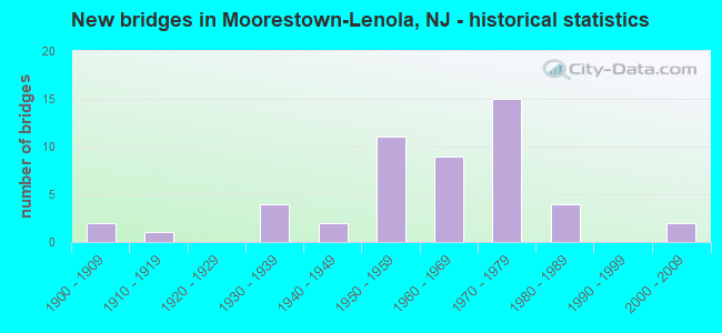
- New bridges - historical statistics
- 21900-1909
- 11910-1919
- 41930-1939
- 21940-1949
- 111950-1959
- 91960-1969
- 151970-1979
- 41980-1989
- 22000-2009

- Reconstructed bridges - Historical Statistics
- 11930-1939
- 01940-1949
- 31950-1959
- 01960-1969
- 01970-1979
- 21980-1989
- 01990-1999
- 12000-2009


- Bridge Condition - Deck
- 36.7%Good
- 46.7%Satisfactory
- 13.3%Fair
- 3.3%Poor

- Bridge Condition - Superstructure
- 5.9%Very good
- 32.4%Good
- 35.3%Satisfactory
- 17.6%Fair
- 8.8%Poor

- Bridge Condition - Substructure
- 2.9%Very good
- 23.5%Good
- 52.9%Satisfactory
- 14.7%Fair
- 2.9%Poor
- 2.9%Serious

- Bridge Condition - Channel
- 5.0%Very good
- 35.0%Good
- 30.0%Satisfactory
- 25.0%Fair
- 5.0%Poor
Find on map >> Show street view
Structure Number: 327166, Location: AT I-295 EXIT 43 (Lat: 39.992061, Lng: -74.877939), Route carried "under" structure: Interstate 295, Year Built: 1971, Structure Length: 0. m, Average Daily Traffic: 139,601 (year 2020), Truck Traffic: 9%, Features Intersected: I-295, Facility Carried by Structure: CREEK ROAD
Minimum Vertical Clearance: 4.65m (15.26ft), Kilometerpoint: 69.363, Lanes on structure: 5, Lanes under structure: 8, Material/Design: Steel, Design/Construction: Stringer/Multi-beam, Length of Maximum Span: 38.1m (125.0ft)
Find on map >> Show street view
Structure Number: 33015, Location: 1.55 MILES E OF US RT 130 (Lat: 39.975739, Lng: -75.011839), Route carried "under" structure: State highway 73, Year Built: 1988, Structure Length: 0. m, Average Daily Traffic: 28,850 (year 2021), Truck Traffic: 4%, Features Intersected: ROUTE NJ 73 SOUTHBOUND, Facility Carried by Structure: ROUTE NJ 90 WB
Minimum Vertical Clearance: 5.18m (16.99ft), Kilometerpoint: 50.598, Lanes on structure: 2, Lanes under structure: 2, Material/Design: Steel, Design/Construction: Stringer/Multi-beam, Length of Maximum Span: 39.0m (128.0ft)
Find on map >> Show street view
Structure Number: M0368, Location: 2 MI NORTH OF EXIT 4 (Lat: 39.955306, Lng: -74.922417), Route carried "under" structure: Other road NJTPK, Year Built: 1950, Structure Length: 0. m, Average Daily Traffic: 81,924 (year 2020), Truck Traffic: 10%, Features Intersected: NJ TURNPIKE, Facility Carried by Structure: MOORSTWN-MT LAUREL
Minimum Vertical Clearance: 4.50m (14.76ft), Kilometerpoint: 59.578, Lanes on structure: 2, Lanes under structure: 6, Toll: On toll road, Material/Design: Steel continuous, Design/Construction: Stringer/Multi-beam, Length of Maximum Span: 19.2m (63.0ft)
Find on map >> Show street view
Structure Number: M03702A, Location: 4 MI NORTH OF EXIT 4 (Lat: 39.957667, Lng: -74.919472), Route carried "under" structure: Other road NJTPK, Year Built: 1965, Structure Length: 0. m, Average Daily Traffic: 81,924 (year 2020), Truck Traffic: 10%, Features Intersected: NJ TURNPIKE, Facility Carried by Structure: NJ TPK U-TURN ROAD
Minimum Vertical Clearance: 4.40m (14.44ft), Kilometerpoint: 59.578, Lanes on structure: 2, Lanes under structure: 6, Toll: On toll road, Material/Design: Steel, Design/Construction: Stringer/Multi-beam, Length of Maximum Span: 19.8m (65.0ft)
Find on map >> Show street view
Structure Number: M03868, Location: 5 MI SOUTH EXIT 5 (Lat: 39.975511, Lng: -74.898525), Route carried "under" structure: County highway 537, Year Built: 1950, Structure Length: 0. m, Average Daily Traffic: 17,766 (year 2020), Truck Traffic: 4%, Features Intersected: MARNE HIGHWAY & PCRR, Facility Carried by Structure: NJ TURNPIKE
Minimum Vertical Clearance: 6.68m (21.92ft), Kilometerpoint: 20.600, Lanes on structure: 6, Lanes under structure: 2, Material/Design: Steel, Design/Construction: Stringer/Multi-beam, Length of Maximum Span: 25.6m (84.0ft)
Find on map >> Show street view
Structure Number: M0389, Location: 4.4 MI NORTH OF EXIT 4 (Lat: 39.977844, Lng: -74.896097), Route carried "under" structure: County highway 686, Year Built: 1950, Structure Length: 0. m, Average Daily Traffic: 10,223 (year 2020), Truck Traffic: 4%, Features Intersected: HARTFORD ROAD, Facility Carried by Structure: NJ TURNPIKE
Minimum Vertical Clearance: 4.34m (14.24ft), Kilometerpoint: 6.518, Lanes on structure: 6, Lanes under structure: 2, Toll: On toll road, Material/Design: Steel, Design/Construction: Stringer/Multi-beam, Length of Maximum Span: 12.8m (42.0ft)
Find on map >> Show street view
Structure Number: M04034, Location: 3.6 MI SOUTH OF EXIT 5 (Lat: 39.989917, Lng: -74.873611), Route carried "under" structure: Other road NJTPK, Year Built: 1950, Structure Length: 0. m, Average Daily Traffic: 65,204 (year 2020), Truck Traffic: 16%, Features Intersected: NJ TURNPIKE, Facility Carried by Structure: CREEK ROAD
Minimum Vertical Clearance: 4.51m (14.80ft), Kilometerpoint: 65.114, Lanes on structure: 2, Lanes under structure: 6, Toll: On toll road, Material/Design: Steel, Design/Construction: Stringer/Multi-beam, Length of Maximum Span: 18.6m (61.0ft)