Bridge Statistics for Mooresville, North Carolina (NC)
Condition, Traffic, Stress, Structural Evaluation, Project Costs
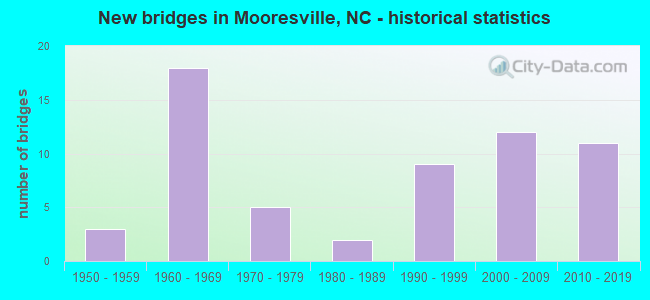
- New bridges - historical statistics
- 31950-1959
- 181960-1969
- 51970-1979
- 21980-1989
- 91990-1999
- 122000-2009
- 112010-2019
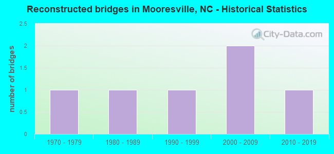
- Reconstructed bridges - Historical Statistics
- 11970-1979
- 11980-1989
- 11990-1999
- 22000-2009
- 12010-2019
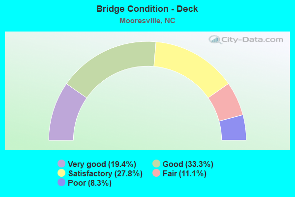
- Bridge Condition - Deck
- 19.4%Very good
- 33.3%Good
- 27.8%Satisfactory
- 11.1%Fair
- 8.3%Poor
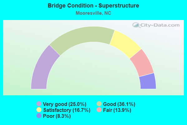
- Bridge Condition - Superstructure
- 25.0%Very good
- 36.1%Good
- 16.7%Satisfactory
- 13.9%Fair
- 8.3%Poor
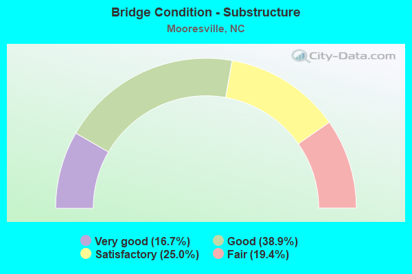
- Bridge Condition - Substructure
- 16.7%Very good
- 38.9%Good
- 25.0%Satisfactory
- 19.4%Fair
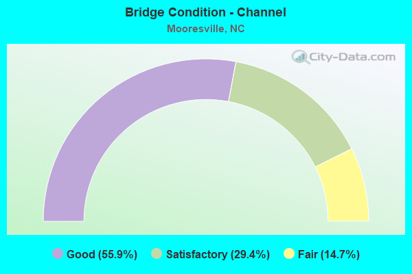
- Bridge Condition - Channel
- 55.9%Good
- 29.4%Satisfactory
- 14.7%Fair
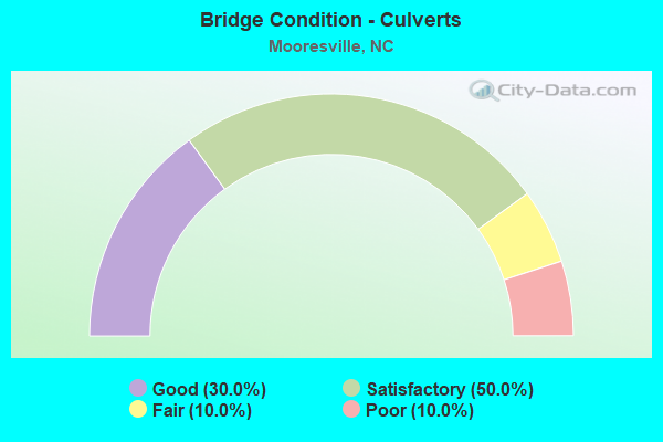
- Bridge Condition - Culverts
- 30.0%Good
- 50.0%Satisfactory
- 10.0%Fair
- 10.0%Poor
Find on map >> Show street view
Structure Number: 183106, Location: 0.7 MI.E.JCT.NC55 (Lat: 35.847094, Lng: -78.870308), Route carried "on" structure: State highway 540, Year Built: 2007, Status: Open, Structure Length: 6.98m (22.90ft), Average Daily Traffic: 23,250 (year 2019), Truck Traffic: 12%, Average Future Daily Traffic: 465,000 (year 2040), Design Load: HS 20+Mod, Features Intersected: SR2153
Minimum Vertical Clearance: 30+ m (98+ ft), Kilometerpoint: 20.424, Lanes on structure: 4, Lanes under structure: 2, Base Highway Network: Yes (Inventory Route: 3, Subroute: 40), Toll: On toll road, Owner: State Highway Agency, Approaching Roadway Width: 25.2m (82.7ft), Skew: 13 degrees, Material/Design: Prestressed concrete continuous, Design/Construction: Stringer/Multi-beam, Number Of Spans In Main Unit: 2, Number Of Approach Spans: 3, Length of Maximum Span: 35.6m (116.8ft), Curb-To-Curb Width: 24.4m (80.1ft), Out-to-Out Width: 25.4m (83.3ft)
Condition: Deck: Good, Superstructure: Good, Substructure: Good, Operating Rating: 71.6 metric tons, Method Used To Determine Operating Rating: Load Factor (LF), Inventory Rating: 32.6 metric tons, Method Used To Determine Inventory Rating: Load Factor (LF), Structural Evaluation: Better than present minimum criteria, Deck Geometry: High priority of corrective action, Underclear: Superior to present desirable criteria, Approach Roadway Alignment: Equal to present desirable criteria, Designated Inspection Frequency: Every 24 months, Inspection Date: April 2021, Deck Structure Type: Concrete Cast-file-Place, Wearing Surface/Protective System: Wearing Surface: Monolithic Concrete, Deck Protection: Epoxy Coated Reinforcing
Find on map >> Show street view
Structure Number: 1831061, Location: 0.8 MI. E. JCT. NC55 (Lat: 35.846883, Lng: -78.869914), Route carried "on" structure: State highway 540, Year Built: 2007, Status: Open, Structure Length: 6.98m (22.90ft), Average Daily Traffic: 23,250 (year 2019), Truck Traffic: 12%, Average Future Daily Traffic: 46,500 (year 2040), Design Load: HS 20+Mod, Features Intersected: SR 2153
Minimum Vertical Clearance: 30+ m (98+ ft), Kilometerpoint: 20.424, Lanes on structure: 4, Lanes under structure: 2, Base Highway Network: Yes (Inventory Route: 9, Subroute: 23), Owner: State Highway Agency, Approaching Roadway Width: 21.0m (68.9ft), Skew: 13 degrees, Material/Design: Prestressed concrete continuous, Design/Construction: Stringer/Multi-beam, Number Of Spans In Main Unit: 2, Length of Maximum Span: 35.3m (115.8ft), Curb-To-Curb Width: 21.0m (68.9ft), Out-to-Out Width: 21.9m (71.9ft)
Condition: Deck: Good, Superstructure: Good, Substructure: Good, Operating Rating: 72.5 metric tons, Method Used To Determine Operating Rating: Load Factor (LF), Inventory Rating: 31.7 metric tons, Method Used To Determine Inventory Rating: Load Factor (LF), Structural Evaluation: Better than present minimum criteria, Deck Geometry: High priority of corrective action, Underclear: Superior to present desirable criteria, Approach Roadway Alignment: Equal to present desirable criteria, Designated Inspection Frequency: Every 24 months, Inspection Date: April 2021, Deck Structure Type: Concrete Cast-file-Place, Wearing Surface/Protective System: Wearing Surface: Monolithic Concrete, Deck Protection: Epoxy Coated Reinforcing
Find on map >> Show street view
Structure Number: 1831209, Location: 0.3 MI.S.JCT.NC54 (Lat: 35.803686, Lng: -78.815117), Route carried "on" structure: State highway 3112, Year Built: 2001, Status: Open, Structure Length: 11.24m (36.88ft), Average Daily Traffic: 13,500 (year 2017), Truck Traffic: 6%, Average Future Daily Traffic: 27,000 (year 2040), Design Load: HS 20+Mod, Features Intersected: SOUTHERN RAILROAD
Minimum Vertical Clearance: 30+ m (98+ ft), Kilometerpoint: 0.000, Lanes on structure: 2, Owner: State Highway Agency, Approaching Roadway Width: 7.3m (24.0ft), Skew: 15 degrees, Material/Design: Steel continuous, Design/Construction: Stringer/Multi-beam, Number Of Spans In Main Unit: 3, Number Of Approach Spans: 2, Length of Maximum Span: 48.4m (158.8ft), Curb-To-Curb Width: 8.7m (28.5ft), Out-to-Out Width: 9.7m (31.8ft)
Condition: Deck: Good, Superstructure: Good, Substructure: Good, Operating Rating: 89.8 metric tons, Method Used To Determine Operating Rating: Load Factor (LF), Inventory Rating: 58.0 metric tons, Method Used To Determine Inventory Rating: Load Factor (LF), Structural Evaluation: Better than present minimum criteria, Deck Geometry: Meets minimum limits, Underclear: Superior to present desirable criteria, Approach Roadway Alignment: Equal to present desirable criteria, Designated Inspection Frequency: Every 24 months, Inspection Date: January 2022, Deck Structure Type: Concrete Cast-file-Place, Wearing Surface/Protective System: Wearing Surface: Monolithic Concrete, Deck Protection: Epoxy Coated Reinforcing
Find on map >> Show street view
Structure Number: 970018, Location: 0.71 MI. N. JCT. SR 1100 (Lat: 35.589008, Lng: -80.837908), Route carried "under" structure: State highway 150, Year Built: 1995, Structure Length: 0. m, Average Daily Traffic: 19,500 (year 2015), Truck Traffic: 12%, Features Intersected: US21
Minimum Vertical Clearance: 4.87m (15.98ft), Kilometerpoint: 0.000, Lanes on structure: 2, Lanes under structure: 4, Material/Design: Steel, Design/Construction: Stringer/Multi-beam, Length of Maximum Span: 25.6m (84.0ft)
Find on map >> Show street view
Structure Number: 970026, Location: 0.4 MI. E. JCT. SR1474 (Lat: 35.593894, Lng: -80.859814), Route carried "under" structure: Interstate 77, Year Built: 1966, Structure Length: 0. m, Average Daily Traffic: 31,500 (year 2019), Truck Traffic: 16%, Features Intersected: NC150
Minimum Vertical Clearance: 5.30m (17.39ft), Kilometerpoint: 10.972, Lanes on structure: 6, Lanes under structure: 2, Material/Design: Prestressed concrete, Design/Construction: Stringer/Multi-beam, Length of Maximum Span: 19.8m (65.0ft)
Find on map >> Show street view
Structure Number: 970026, Location: 0.4 MI. E. JCT. SR1474 (Lat: 35.593894, Lng: -80.859814), Route carried "under" structure: Interstate 77, Year Built: 1966, Structure Length: 0. m, Average Daily Traffic: 31,500 (year 2019), Truck Traffic: 16%, Features Intersected: NC150
Minimum Vertical Clearance: 5.71m (18.73ft), Kilometerpoint: 10.972, Lanes on structure: 6, Lanes under structure: 3, Material/Design: Prestressed concrete, Design/Construction: Stringer/Multi-beam, Length of Maximum Span: 19.8m (65.0ft)
Find on map >> Show street view
Structure Number: 970028, Location: 0.1 MI. W. JCT. SR1104 (Lat: 35.530606, Lng: -80.862208), Route carried "under" structure: Interstate 77, Year Built: 2009, Structure Length: 0. m, Average Daily Traffic: 39,750 (year 2019), Truck Traffic: 16%, Features Intersected: SR1102
Minimum Vertical Clearance: 5.73m (18.80ft), Kilometerpoint: 9.619, Lanes on structure: 5, Lanes under structure: 2, Material/Design: Steel continuous, Design/Construction: Stringer/Multi-beam, Length of Maximum Span: 44.8m (147.0ft)
Find on map >> Show street view
Structure Number: 970028, Location: 0.1 MI. W. JCT. SR1104 (Lat: 35.530606, Lng: -80.862208), Route carried "under" structure: Interstate 77, Year Built: 2009, Structure Length: 0. m, Average Daily Traffic: 39,750 (year 2019), Truck Traffic: 16%, Features Intersected: SR1102
Minimum Vertical Clearance: 5.66m (18.57ft), Kilometerpoint: 9.619, Lanes on structure: 5, Lanes under structure: 2, Material/Design: Steel continuous, Design/Construction: Stringer/Multi-beam, Length of Maximum Span: 44.8m (147.0ft)
Find on map >> Show street view
Structure Number: 970049, Location: 0.1 MI. W. JCT. SR1246 (Lat: 35.553283, Lng: -80.857658), Route carried "under" structure: Interstate 77, Year Built: 1966, Structure Length: 0. m, Average Daily Traffic: 41,500 (year 2015), Truck Traffic: 16%, Features Intersected: US21
Minimum Vertical Clearance: 5.81m (19.06ft), Kilometerpoint: 10.104, Lanes on structure: 4, Lanes under structure: 3, Material/Design: Steel, Design/Construction: Stringer/Multi-beam, Length of Maximum Span: 23.4m (76.8ft)
Find on map >> Show street view
Structure Number: 970049, Location: 0.1 MI. W. JCT. SR1246 (Lat: 35.553283, Lng: -80.857658), Route carried "under" structure: Interstate 77, Year Built: 1966, Structure Length: 0. m, Average Daily Traffic: 41,500 (year 2015), Truck Traffic: 16%, Features Intersected: US21
Minimum Vertical Clearance: 5.33m (17.49ft), Kilometerpoint: 10.104, Lanes on structure: 4, Lanes under structure: 2, Material/Design: Steel, Design/Construction: Stringer/Multi-beam, Length of Maximum Span: 23.4m (76.8ft)
Find on map >> Show street view
Structure Number: 97007, Location: 0.2 MI.W. JCT. SR1116 (Lat: 35.579839, Lng: -80.856175), Route carried "under" structure: Interstate 77, Year Built: 2011, Structure Length: 0. m, Average Daily Traffic: 31,000 (year 2015), Truck Traffic: 16%, Features Intersected: SR1100
Minimum Vertical Clearance: 5.74m (18.83ft), Kilometerpoint: 10.665, Lanes on structure: 9, Lanes under structure: 2, Material/Design: Prestressed concrete, Design/Construction: Stringer/Multi-beam, Length of Maximum Span: 23.4m (76.8ft)
Find on map >> Show street view
Structure Number: 97007, Location: 0.2 MI.W. JCT. SR1116 (Lat: 35.579839, Lng: -80.856175), Route carried "under" structure: Interstate 77, Year Built: 2011, Structure Length: 0. m, Average Daily Traffic: 31,000 (year 2015), Truck Traffic: 16%, Features Intersected: SR1100
Minimum Vertical Clearance: 5.91m (19.39ft), Kilometerpoint: 10.665, Lanes on structure: 9, Lanes under structure: 2, Material/Design: Prestressed concrete, Design/Construction: Stringer/Multi-beam, Length of Maximum Span: 23.4m (76.8ft)
Find on map >> Show street view
Structure Number: 97008, Location: 0.4 MI. E. JCT. SR1433 (Lat: 35.623847, Lng: -80.860119), Route carried "under" structure: Interstate 77, Year Built: 1966, Structure Length: 0. m, Average Daily Traffic: 29,500 (year 2019), Truck Traffic: 16%, Features Intersected: SR1302
Minimum Vertical Clearance: 5.69m (18.67ft), Kilometerpoint: 11.613, Lanes on structure: 2, Lanes under structure: 2, Material/Design: Steel, Design/Construction: Stringer/Multi-beam, Length of Maximum Span: 29.2m (95.8ft)
Find on map >> Show street view
Structure Number: 97008, Location: 0.4 MI. E. JCT. SR1433 (Lat: 35.623847, Lng: -80.860119), Route carried "under" structure: Interstate 77, Year Built: 1966, Structure Length: 0. m, Average Daily Traffic: 29,500 (year 2019), Truck Traffic: 16%, Features Intersected: SR1302
Minimum Vertical Clearance: 4.86m (15.94ft), Kilometerpoint: 11.613, Lanes on structure: 2, Lanes under structure: 2, Material/Design: Steel, Design/Construction: Stringer/Multi-beam, Length of Maximum Span: 29.2m (95.8ft)
Find on map >> Show street view
Structure Number: 970089, Location: 0.2 MI. N. JCT. SR1300 (Lat: 35.640100, Lng: -80.864072), Route carried "under" structure: Interstate 77, Year Built: 1966, Structure Length: 0. m, Average Daily Traffic: 28,000 (year 2015), Truck Traffic: 23%, Features Intersected: SR1311
Minimum Vertical Clearance: 5.71m (18.73ft), Kilometerpoint: 11.960, Lanes on structure: 2, Lanes under structure: 2, Material/Design: Steel, Design/Construction: Stringer/Multi-beam, Length of Maximum Span: 27.1m (88.9ft)
Find on map >> Show street view
Structure Number: 970089, Location: 0.2 MI. N. JCT. SR1300 (Lat: 35.640100, Lng: -80.864072), Route carried "under" structure: Interstate 77, Year Built: 1966, Structure Length: 0. m, Average Daily Traffic: 28,000 (year 2015), Truck Traffic: 23%, Features Intersected: SR1311
Minimum Vertical Clearance: 5.11m (16.77ft), Kilometerpoint: 11.960, Lanes on structure: 2, Lanes under structure: 2, Material/Design: Steel, Design/Construction: Stringer/Multi-beam, Length of Maximum Span: 27.1m (88.9ft)
Find on map >> Show street view
Structure Number: 1831061, Location: 0.8 MI. E. JCT. NC55 (Lat: 35.846883, Lng: -78.869914), Route carried "under" structure: State highway 2153, Year Built: 2007, Structure Length: 0. m, Average Daily Traffic: 2,600 (year 2015), Truck Traffic: 7%, Features Intersected: NC 540 N
Minimum Vertical Clearance: 5.41m (17.75ft), Kilometerpoint: 0.000, Lanes on structure: 4, Lanes under structure: 2, Material/Design: Prestressed concrete continuous, Design/Construction: Stringer/Multi-beam, Length of Maximum Span: 35.3m (115.8ft)