Bridge Statistics for Naperville, Illinois (IL)
Condition, Traffic, Stress, Structural Evaluation, Project Costs
- National Bridge Inventory (NBI) Statistics
- 47Number of bridges
- 479ft / 146mTotal length
- $5,102,000Total costs
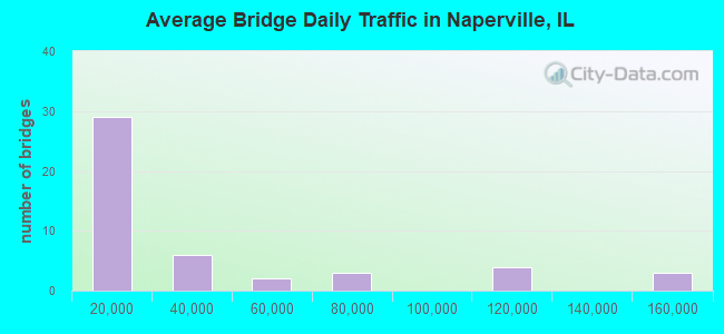
- 1,609,125Total average daily traffic
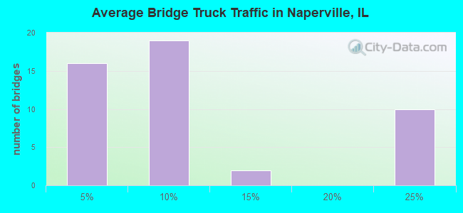
- 269,891Total average daily truck traffic
- National Bridge Inventory (NBI) Registered Bridges for Naperville
- No street view available for this location
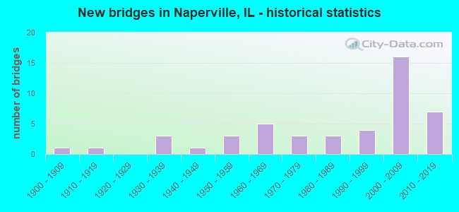
- New bridges - historical statistics
- 11900-1909
- 11910-1919
- 31930-1939
- 11940-1949
- 31950-1959
- 51960-1969
- 31970-1979
- 31980-1989
- 41990-1999
- 162000-2009
- 72010-2019
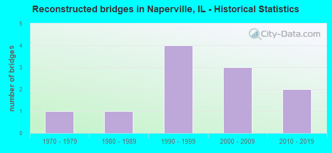
- Reconstructed bridges - Historical Statistics
- 11970-1979
- 11980-1989
- 41990-1999
- 32000-2009
- 22010-2019
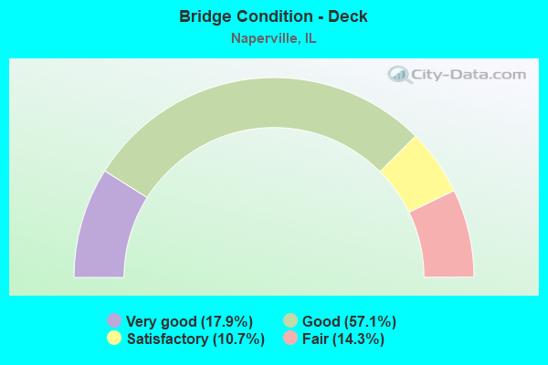
- Bridge Condition - Deck
- 17.9%Very good
- 57.1%Good
- 10.7%Satisfactory
- 14.3%Fair
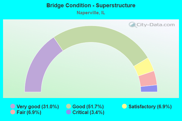
- Bridge Condition - Superstructure
- 31.0%Very good
- 51.7%Good
- 6.9%Satisfactory
- 6.9%Fair
- 3.4%Critical
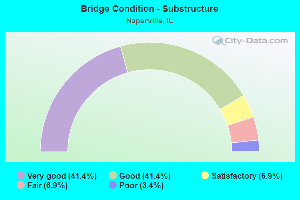
- Bridge Condition - Substructure
- 41.4%Very good
- 41.4%Good
- 6.9%Satisfactory
- 6.9%Fair
- 3.4%Poor
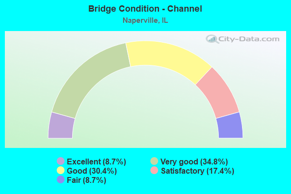
- Bridge Condition - Channel
- 8.7%Excellent
- 34.8%Very good
- 30.4%Good
- 17.4%Satisfactory
- 8.7%Fair
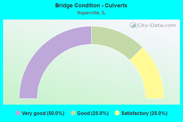
- Bridge Condition - Culverts
- 50.0%Very good
- 25.0%Good
- 25.0%Satisfactory
Find on map >> Show street view
Structure Number: 229991, Location: 0.3MI W OF NAPER RD (Lat: 41.806203, Lng: -88.124906), Route carried "under" structure: Other road , Year Built: 2008, Structure Length: 0. m, Average Daily Traffic: 3,600 (year 2020), Truck Traffic: 6%, Features Intersected: FREEDOM DRIVE, Facility Carried by Structure: I88 WB RON REAGAN
Minimum Vertical Clearance: 4.98m (16.34ft), Kilometerpoint: 0.354, Lanes on structure: 4, Lanes under structure: 3, Toll: On toll road, Material/Design: Prestressed concrete, Design/Construction: Stringer/Multi-beam, Length of Maximum Span: 31.5m (103.3ft)
Find on map >> Show street view
Structure Number: 229992, Location: 0.1MI N OGDEN AVE (Lat: 41.805781, Lng: -88.119372), Route carried "under" structure: Other road , Year Built: 2007, Structure Length: 0. m, Average Daily Traffic: 12,700 (year 2020), Truck Traffic: 4%, Features Intersected: NAPERVILLE/WHEAT RD, Facility Carried by Structure: I88 EB E-W TOLL
Minimum Vertical Clearance: 4.67m (15.32ft), Kilometerpoint: 6.180, Lanes on structure: 5, Lanes under structure: 4, Toll: On toll road, Material/Design: Steel, Design/Construction: Stringer/Multi-beam, Length of Maximum Span: 31.4m (103.0ft)
Find on map >> Show street view
Structure Number: 229993, Location: 0.1MI N OGDEN AVE (Lat: 41.806089, Lng: -88.119186), Route carried "under" structure: Other road , Year Built: 2008, Structure Length: 0. m, Average Daily Traffic: 12,700 (year 2020), Truck Traffic: 4%, Features Intersected: NAPERVILLE/WHEAT RD, Facility Carried by Structure: I88 WB E-W TOLL
Minimum Vertical Clearance: 4.67m (15.32ft), Kilometerpoint: 6.148, Lanes on structure: 6, Lanes under structure: 4, Toll: On toll road, Material/Design: Steel, Design/Construction: Stringer/Multi-beam, Length of Maximum Span: 31.4m (103.0ft)
Find on map >> Show street view
Structure Number: 229995, Location: 2.3 MI E IL59 (Lat: 41.806289, Lng: -88.157050), Route carried "under" structure: Interstate 88, Year Built: 2005, Structure Length: 0. m, Average Daily Traffic: 146,800 (year 2019), Truck Traffic: 22%, Features Intersected: I-88 REAGAN TOLLWAY, Facility Carried by Structure: MILL ST
Minimum Vertical Clearance: 4.98m (16.34ft), Kilometerpoint: 202.032, Lanes on structure: 4, Lanes under structure: 8, Material/Design: Steel, Design/Construction: Stringer/Multi-beam, Length of Maximum Span: 35.7m (117.1ft)