Bridge Statistics for Neosho, Missouri (MO)
Condition, Traffic, Stress, Structural Evaluation, Project Costs
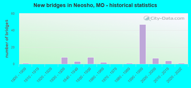
- New bridges - historical statistics
- 11900-1909
- 81930-1939
- 31940-1949
- 81950-1959
- 21960-1969
- 11980-1989
- 471990-1999
- 72000-2009
- 42010-2019
- 12020-2022

- Reconstructed bridges - Historical Statistics
- 21940-1949
- 01950-1959
- 01960-1969
- 11970-1979
- 11980-1989


- Bridge Condition - Deck
- 9.8%Excellent
- 31.4%Very good
- 39.2%Good
- 15.7%Satisfactory
- 3.9%Fair

- Bridge Condition - Superstructure
- 3.9%Excellent
- 19.6%Very good
- 56.9%Good
- 11.8%Satisfactory
- 7.8%Fair

- Bridge Condition - Substructure
- 9.8%Excellent
- 35.3%Very good
- 23.5%Good
- 23.5%Satisfactory
- 7.8%Fair

- Bridge Condition - Channel
- 5.8%Excellent
- 5.8%Very good
- 23.1%Good
- 40.4%Satisfactory
- 23.1%Fair
- 1.9%Poor

- Bridge Condition - Culverts
- 20.0%Good
- 53.3%Satisfactory
- 13.3%Fair
- 13.3%Poor
Find on map >> Show street view
Structure Number: 36438, Location: S 20 T 25 N R 31 W (Lat: 36.866200, Lng: -94.350000), Route carried "on" structure: ServiceOther road , Year Built: 1950, Status: Posted for load, Structure Length: 0.61m (2.00ft), Average Daily Traffic: 10 (year 2021), Truck Traffic: 10%, Average Future Daily Traffic: 17 (year 2041), Features Intersected: DRAIN DTCH, Facility Carried by Structure: PVT 86-1 S
Minimum Vertical Clearance: 30+ m (98+ ft), Kilometerpoint: 0.032, Lanes on structure: 1, Owner: State Highway Agency, Approaching Roadway Width: 4.9m (16.1ft), Material/Design: Wood or Timber, Design/Construction: Stringer/Multi-beam, Number Of Spans In Main Unit: 1, Length of Maximum Span: 6.1m (20.0ft), Curb-To-Curb Width: 4.9m (16.1ft), Out-to-Out Width: 5.2m (17.1ft)
Condition: Deck: Satisfactory, Superstructure: Satisfactory, Substructure: Satisfactory, Channel: Satisfactory, Operating Rating: 5.4 metric tons, Method Used To Determine Operating Rating: Allowable Stress (AS), Inventory Rating: 3.6 metric tons, Method Used To Determine Inventory Rating: Allowable Stress (AS), Structural Evaluation: High priority of replacement, Deck Geometry: High priority of corrective action, Waterway Adequacy: Equal to present minimum criteria, Approach Roadway Alignment: Equal to present minimum criteria, Bridge Posting: Required (Relationship of Operating Rating to Maximum Legal Load: > 39.9% below), Length Of Structure Improvement: 0.12m (0.39ft), Designated Inspection Frequency: Every 24 months, Inspection Date: September 2021, Bridge Improvement Cost: $94,000, Roadway Improvement Cost: $9,000, Total Project Cost: $140,000 ( Estimate for 2022), Deck Structure Type: Wood or Timber, Wearing Surface/Protective System: Wearing Surface: Wood or Timber
Find on map >> Show street view
Structure Number: 3644, Location: S 20 T 25 N R 31 W (Lat: 36.867400, Lng: -94.347100), Route carried "on" structure: ServiceOther road , Year Built: 1950, Status: Posted for load, Structure Length: 0.59m (1.94ft), Average Daily Traffic: 10 (year 2021), Truck Traffic: 10%, Average Future Daily Traffic: 17 (year 2041), Features Intersected: DRAIN DTCH, Facility Carried by Structure: PVT 86-2 S
Minimum Vertical Clearance: 30+ m (98+ ft), Kilometerpoint: 0.014, Lanes on structure: 1, Owner: State Highway Agency, Approaching Roadway Width: 4.6m (15.1ft), Material/Design: Wood or Timber, Design/Construction: Stringer/Multi-beam, Number Of Spans In Main Unit: 1, Length of Maximum Span: 5.9m (19.4ft), Curb-To-Curb Width: 4.6m (15.1ft), Out-to-Out Width: 5.0m (16.4ft)
Condition: Deck: Satisfactory, Superstructure: Satisfactory, Substructure: Satisfactory, Channel: Satisfactory, Operating Rating: 5.4 metric tons, Method Used To Determine Operating Rating: Allowable Stress (AS), Inventory Rating: 3.6 metric tons, Method Used To Determine Inventory Rating: Allowable Stress (AS), Structural Evaluation: High priority of corrective action, Deck Geometry: Better than present minimum criteria, Waterway Adequacy: Equal to present minimum criteria, Approach Roadway Alignment: Equal to present minimum criteria, Bridge Posting: Required (Relationship of Operating Rating to Maximum Legal Load: > 39.9% below), Designated Inspection Frequency: Every 24 months, Inspection Date: September 2021, Deck Structure Type: Wood or Timber, Wearing Surface/Protective System: Wearing Surface: Wood or Timber
Find on map >> Show street view
Structure Number: 36441, Location: S 20 T 25 N R 31 W (Lat: 36.868500, Lng: -94.344700), Route carried "on" structure: ServiceOther road , Year Built: 1950, Status: Posted for load, Structure Length: 0.59m (1.94ft), Average Daily Traffic: 10 (year 2021), Truck Traffic: 10%, Average Future Daily Traffic: 17 (year 2041), Features Intersected: DRAIN DTCH, Facility Carried by Structure: PVT 86-3 E
Minimum Vertical Clearance: 30+ m (98+ ft), Kilometerpoint: 0.019, Lanes on structure: 1, Owner: State Highway Agency, Approaching Roadway Width: 4.9m (16.1ft), Material/Design: Wood or Timber, Design/Construction: Stringer/Multi-beam, Number Of Spans In Main Unit: 1, Length of Maximum Span: 5.9m (19.4ft), Curb-To-Curb Width: 4.9m (16.1ft), Out-to-Out Width: 5.0m (16.4ft)
Condition: Deck: Satisfactory, Superstructure: Good, Substructure: Satisfactory, Channel: Very good, Operating Rating: 5.4 metric tons, Method Used To Determine Operating Rating: Allowable Stress (AS), Inventory Rating: 3.6 metric tons, Method Used To Determine Inventory Rating: Allowable Stress (AS), Structural Evaluation: High priority of corrective action, Deck Geometry: High priority of corrective action, Waterway Adequacy: Equal to present minimum criteria, Approach Roadway Alignment: Equal to present minimum criteria, Bridge Posting: Required (Relationship of Operating Rating to Maximum Legal Load: > 39.9% below), Designated Inspection Frequency: Every 24 months, Inspection Date: September 2021, Deck Structure Type: Wood or Timber, Wearing Surface/Protective System: Wearing Surface: Wood or Timber
Find on map >> Show street view
Structure Number: 36442, Location: S 20 T 25 N R 31 W (Lat: 36.870500, Lng: -94.340400), Route carried "on" structure: ServiceOther road , Year Built: 1950, Status: Posted for load, Structure Length: 0.66m (2.17ft), Average Daily Traffic: 10 (year 2021), Truck Traffic: 10%, Average Future Daily Traffic: 17 (year 2041), Features Intersected: DRAIN DTCH, Facility Carried by Structure: PVT 86-4 S
Minimum Vertical Clearance: 30+ m (98+ ft), Kilometerpoint: 0.037, Lanes on structure: 1, Owner: State Highway Agency, Approaching Roadway Width: 4.9m (16.1ft), Material/Design: Wood or Timber, Design/Construction: Stringer/Multi-beam, Number Of Spans In Main Unit: 1, Length of Maximum Span: 6.4m (21.0ft), Curb-To-Curb Width: 4.9m (16.1ft), Out-to-Out Width: 5.0m (16.4ft)
Condition: Deck: Satisfactory, Superstructure: Good, Substructure: Good, Channel: Satisfactory, Operating Rating: 10.8 metric tons, Method Used To Determine Operating Rating: Allowable Stress (AS), Inventory Rating: 7.2 metric tons, Method Used To Determine Inventory Rating: Allowable Stress (AS), Structural Evaluation: High priority of replacement, Deck Geometry: High priority of corrective action, Waterway Adequacy: Equal to present minimum criteria, Approach Roadway Alignment: Equal to present minimum criteria, Bridge Posting: Required (Relationship of Operating Rating to Maximum Legal Load: > 39.9% below), Length Of Structure Improvement: 0.13m (0.43ft), Designated Inspection Frequency: Every 24 months, Inspection Date: September 2021, Bridge Improvement Cost: $103,000, Roadway Improvement Cost: $10,000, Total Project Cost: $155,000 ( Estimate for 2022), Deck Structure Type: Wood or Timber, Wearing Surface/Protective System: Wearing Surface: Wood or Timber
Find on map >> Show street view
Structure Number: 36443, Location: S 20 T 25 N R 31 W (Lat: 36.871300, Lng: -94.337400), Route carried "on" structure: ServiceOther road , Year Built: 1950, Status: Posted for load, Structure Length: 0.53m (1.74ft), Average Daily Traffic: 10 (year 2021), Truck Traffic: 10%, Average Future Daily Traffic: 17 (year 2041), Features Intersected: DRAIN DTCH, Facility Carried by Structure: PVT 86-5 E
Minimum Vertical Clearance: 30+ m (98+ ft), Kilometerpoint: 0.072, Lanes on structure: 1, Owner: State Highway Agency, Approaching Roadway Width: 4.7m (15.4ft), Material/Design: Wood or Timber, Design/Construction: Stringer/Multi-beam, Number Of Spans In Main Unit: 1, Length of Maximum Span: 5.2m (17.1ft), Curb-To-Curb Width: 4.7m (15.4ft), Out-to-Out Width: 4.9m (16.1ft)
Condition: Deck: Satisfactory, Superstructure: Fair, Substructure: Satisfactory, Channel: Satisfactory, Operating Rating: 10.8 metric tons, Method Used To Determine Operating Rating: Allowable Stress (AS), Inventory Rating: 7.2 metric tons, Method Used To Determine Inventory Rating: Allowable Stress (AS), Structural Evaluation: High priority of corrective action, Deck Geometry: Better than present minimum criteria, Waterway Adequacy: Equal to present minimum criteria, Approach Roadway Alignment: Equal to present minimum criteria, Bridge Posting: Required (Relationship of Operating Rating to Maximum Legal Load: > 39.9% below), Designated Inspection Frequency: Every 24 months, Inspection Date: September 2021, Deck Structure Type: Wood or Timber, Wearing Surface/Protective System: Wearing Surface: Wood or Timber
Find on map >> Show street view
Structure Number: 36444, Location: S 21 T 25 N R 31 W (Lat: 36.871500, Lng: -94.334083), Route carried "on" structure: ServiceOther road , Year Built: 1950, Status: Posted for load, Structure Length: 0.47m (1.54ft), Average Daily Traffic: 10 (year 2021), Truck Traffic: 10%, Average Future Daily Traffic: 17 (year 2041), Features Intersected: DRAIN DTCH, Facility Carried by Structure: PVT 86-6 S
Minimum Vertical Clearance: 30+ m (98+ ft), Kilometerpoint: 0.026, Lanes on structure: 1, Owner: State Highway Agency, Approaching Roadway Width: 4.9m (16.1ft), Material/Design: Wood or Timber, Design/Construction: Stringer/Multi-beam, Number Of Spans In Main Unit: 1, Length of Maximum Span: 4.6m (15.1ft), Curb-To-Curb Width: 4.9m (16.1ft), Out-to-Out Width: 5.0m (16.4ft)
Condition: Deck: Satisfactory, Superstructure: Good, Substructure: Fair, Channel: Fair, Operating Rating: 10.8 metric tons, Method Used To Determine Operating Rating: Allowable Stress (AS), Inventory Rating: 7.2 metric tons, Method Used To Determine Inventory Rating: Allowable Stress (AS), Structural Evaluation: High priority of corrective action, Deck Geometry: High priority of corrective action, Waterway Adequacy: Equal to present minimum criteria, Approach Roadway Alignment: Equal to present minimum criteria, Bridge Posting: Required (Relationship of Operating Rating to Maximum Legal Load: > 39.9% below), Designated Inspection Frequency: Every 24 months, Inspection Date: September 2021, Deck Structure Type: Wood or Timber, Wearing Surface/Protective System: Wearing Surface: Wood or Timber
Find on map >> Show street view
Structure Number: 36569, Location: S 19 T 25 N R 31 W (Lat: 36.872750, Lng: -94.363397), Route carried "on" structure: City street , Year Built: 2021, Status: Not yet open, Structure Length: 4.45m (14.60ft), Average Daily Traffic: 500 (year 2021), Truck Traffic: 10%, Average Future Daily Traffic: 825 (year 2041), Design Load: HS 20, Features Intersected: HICKORY CR, Facility Carried by Structure: COLER ST
Minimum Vertical Clearance: 30+ m (98+ ft), Kilometerpoint: 0.161, Lanes on structure: 2, Owner: City or Municipal Highway Agency, Approaching Roadway Width: 6.7m (22.0ft), Skew: 1 degrees, Material/Design: Prestressed concrete continuous, Design/Construction: Stringer/Multi-beam, Number Of Spans In Main Unit: 3, Length of Maximum Span: 14.1m (46.3ft), Curb or Sidewalk Widths: Left: 2.4m (7.9ft), Right: 2.4m (7.9ft), Curb-To-Curb Width: 7.9m (25.9ft), Out-to-Out Width: 14.0m (45.9ft)
Condition: Deck: Excellent, Superstructure: Excellent, Substructure: Excellent, Channel: Excellent, Operating Rating: 61.2 metric tons, Method Used To Determine Operating Rating: Load Factor (LF), Inventory Rating: 47.7 metric tons, Method Used To Determine Inventory Rating: Load Factor (LF), Structural Evaluation: Superior to present desirable criteria, Deck Geometry: Somewhat better than minimum adequacy, Waterway Adequacy: Equal to present desirable criteria, Approach Roadway Alignment: Equal to present desirable criteria, Designated Inspection Frequency: Every 24 months, Inspection Date: May 2021, Deck Structure Type: Concrete Cast-file-Place, Wearing Surface/Protective System: Wearing Surface: Monolithic Concrete, Deck Protection: Epoxy Coated Reinforcing
Find on map >> Show street view
Structure Number: 3993, Location: S 24 T 25 N R 32 W (Lat: 36.868375, Lng: -94.387292), Route carried "on" structure: City street , Year Built: 1992, Status: Open, Structure Length: 0.63m (2.07ft), Average Daily Traffic: 1,582 (year 2021), Truck Traffic: 5%, Average Future Daily Traffic: 2,610 (year 2041), Design Load: HS 20, Features Intersected: W HIGH SCHOOL BR, Facility Carried by Structure: HILLCREST DR S
Minimum Vertical Clearance: 30+ m (98+ ft), Kilometerpoint: 0.016, Lanes on structure: 2, Owner: State Highway Agency, Approaching Roadway Width: 8.5m (27.9ft), Skew: 20 degrees, Material/Design: Concrete continuous, Design/Construction: Culvert, Number Of Spans In Main Unit: 2, Length of Maximum Span: 3.0m (9.8ft)
Condition: Channel: Very good, Culverts: Good, Inventory Rating: 64.8 metric tons, Method Used To Determine Inventory Rating: Load Factor (LF), Structural Evaluation: Better than present minimum criteria, Waterway Adequacy: Equal to present desirable criteria, Approach Roadway Alignment: Equal to present desirable criteria, Designated Inspection Frequency: Every 24 months, Inspection Date: Febuary 2022
Find on map >> Show street view
Structure Number: 3994, Location: S 24 T 25 N R 32 W (Lat: 36.868931, Lng: -94.383914), Route carried "on" structure: City street , Year Built: 1992, Status: Open, Structure Length: 0.75m (2.46ft), Average Daily Traffic: 950 (year 2020), Truck Traffic: 10%, Average Future Daily Traffic: 1,568 (year 2040), Design Load: HS 20, Features Intersected: W HIGH SCHOOL BR, Facility Carried by Structure: MAGADAM RD CONNECT
Minimum Vertical Clearance: 30+ m (98+ ft), Kilometerpoint: 0.008, Lanes on structure: 2, Owner: State Highway Agency, Approaching Roadway Width: 6.4m (21.0ft), Skew: 20 degrees, Material/Design: Concrete continuous, Design/Construction: Culvert, Number Of Spans In Main Unit: 2, Length of Maximum Span: 3.7m (12.1ft)
Condition: Channel: Excellent, Culverts: Satisfactory, Operating Rating: 80.1 metric tons, Method Used To Determine Operating Rating: Load Factor (LF), Inventory Rating: 47.7 metric tons, Method Used To Determine Inventory Rating: Load Factor (LF), Structural Evaluation: Equal to present minimum criteria, Waterway Adequacy: Equal to present desirable criteria, Approach Roadway Alignment: Equal to present desirable criteria, Designated Inspection Frequency: Every 24 months, Inspection Date: Febuary 2022
Find on map >> Show street view
Structure Number: 422, Location: S 16 T 25 N R 32 W (Lat: 36.880569, Lng: -94.430931), Route carried "on" structure: Interstate 49, Year Built: 1996, Status: Open, Structure Length: 5.88m (19.29ft), Average Daily Traffic: 10,094 (year 2021), Truck Traffic: 30%, Average Future Daily Traffic: 18,674 (year 2041), Design Load: HS 25 or greater, Features Intersected: MO 86
Minimum Vertical Clearance: 30+ m (98+ ft), Kilometerpoint: 43.938, Lanes on structure: 2, Lanes under structure: 4, Base Highway Network: Yes, Owner: State Highway Agency, Approaching Roadway Width: 12.2m (40.0ft), Material/Design: Prestressed concrete continuous, Design/Construction: Stringer/Multi-beam, Number Of Spans In Main Unit: 4, Length of Maximum Span: 14.8m (48.6ft), Curb or Sidewalk Widths: Left: 0.2m (0.7ft), Right: 0.2m (0.7ft), Curb-To-Curb Width: 11.8m (38.7ft), Out-to-Out Width: 12.6m (41.3ft)
Condition: Deck: Good, Superstructure: Good, Substructure: Good, Operating Rating: 78.3 metric tons, Method Used To Determine Operating Rating: Load Factor (LF), Inventory Rating: 44.1 metric tons, Method Used To Determine Inventory Rating: Load Factor (LF), Structural Evaluation: Better than present minimum criteria, Deck Geometry: Equal to present minimum criteria, Underclear: Equal to present minimum criteria, Approach Roadway Alignment: Equal to present desirable criteria, Designated Inspection Frequency: Every 24 months, Inspection Date: September 2021, Deck Structure Type: Concrete Cast-file-Place, Wearing Surface/Protective System: Wearing Surface: Monolithic Concrete, Deck Protection: Epoxy Coated Reinforcing
Find on map >> Show street view
Structure Number: 4221, Location: S 16 T 25 N R 32 W (Lat: 36.880592, Lng: -94.431222), Route carried "on" structure: Interstate 49, Year Built: 1996, Status: Open, Structure Length: 5.88m (19.29ft), Average Daily Traffic: 12,646 (year 2021), Truck Traffic: 24%, Average Future Daily Traffic: 23,395 (year 2041), Design Load: HS 25 or greater, Features Intersected: MO 86
Minimum Vertical Clearance: 30+ m (98+ ft), Kilometerpoint: 252.124, Lanes on structure: 2, Lanes under structure: 4, Base Highway Network: Yes, Owner: State Highway Agency, Approaching Roadway Width: 12.2m (40.0ft), Material/Design: Prestressed concrete continuous, Design/Construction: Stringer/Multi-beam, Number Of Spans In Main Unit: 4, Length of Maximum Span: 14.8m (48.6ft), Curb or Sidewalk Widths: Left: 0.2m (0.7ft), Right: 0.2m (0.7ft), Curb-To-Curb Width: 11.8m (38.7ft), Out-to-Out Width: 12.6m (41.3ft)
Condition: Deck: Good, Superstructure: Good, Substructure: Good, Operating Rating: 78.3 metric tons, Method Used To Determine Operating Rating: Load Factor (LF), Inventory Rating: 44.1 metric tons, Method Used To Determine Inventory Rating: Load Factor (LF), Structural Evaluation: Better than present minimum criteria, Deck Geometry: Equal to present minimum criteria, Underclear: Equal to present minimum criteria, Approach Roadway Alignment: Equal to present desirable criteria, Designated Inspection Frequency: Every 24 months, Inspection Date: September 2021, Deck Structure Type: Concrete Cast-file-Place, Wearing Surface/Protective System: Wearing Surface: Monolithic Concrete, Deck Protection: Epoxy Coated Reinforcing
Find on map >> Show street view
Structure Number: 4243, Location: S 4 T 25 N R 32 W (Lat: 36.924050, Lng: -94.429975), Route carried "on" structure: Interstate 49, Year Built: 1996, Status: Open, Structure Length: 4.45m (14.60ft), Average Daily Traffic: 15,071 (year 2021), Truck Traffic: 30%, Average Future Daily Traffic: 27,881 (year 2041), Design Load: HS 20+Mod, Features Intersected: CRD IRIS RD
Minimum Vertical Clearance: 30+ m (98+ ft), Kilometerpoint: 48.771, Lanes on structure: 2, Lanes under structure: 2, Base Highway Network: Yes, Owner: State Highway Agency, Approaching Roadway Width: 12.2m (40.0ft), Material/Design: Prestressed concrete continuous, Design/Construction: Stringer/Multi-beam, Number Of Spans In Main Unit: 3, Length of Maximum Span: 16.2m (53.1ft), Curb or Sidewalk Widths: Left: 0.2m (0.7ft), Right: 0.2m (0.7ft), Curb-To-Curb Width: 11.8m (38.7ft), Out-to-Out Width: 12.6m (41.3ft)
Condition: Deck: Good, Superstructure: Very good, Substructure: Very good, Operating Rating: 86.4 metric tons, Method Used To Determine Operating Rating: Load Factor (LF), Inventory Rating: 51.3 metric tons, Method Used To Determine Inventory Rating: Load Factor (LF), Structural Evaluation: Equal to present desirable criteria, Deck Geometry: Equal to present minimum criteria, Underclear: Equal to present desirable criteria, Approach Roadway Alignment: Equal to present desirable criteria, Designated Inspection Frequency: Every 24 months, Inspection Date: September 2021, Deck Structure Type: Concrete Cast-file-Place, Wearing Surface/Protective System: Wearing Surface: Monolithic Concrete, Deck Protection: Epoxy Coated Reinforcing
Find on map >> Show street view
Structure Number: 4244, Location: S 4 T 25 N R 32 W (Lat: 36.924000, Lng: -94.430264), Route carried "on" structure: Interstate 49, Year Built: 1996, Status: Open, Structure Length: 4.45m (14.60ft), Average Daily Traffic: 12,646 (year 2021), Truck Traffic: 24%, Average Future Daily Traffic: 23,395 (year 2041), Design Load: HS 20+Mod, Features Intersected: CRD IRIS RD
Minimum Vertical Clearance: 30+ m (98+ ft), Kilometerpoint: 247.315, Lanes on structure: 2, Lanes under structure: 2, Base Highway Network: Yes, Owner: State Highway Agency, Approaching Roadway Width: 12.2m (40.0ft), Material/Design: Prestressed concrete continuous, Design/Construction: Stringer/Multi-beam, Number Of Spans In Main Unit: 3, Length of Maximum Span: 16.2m (53.1ft), Curb or Sidewalk Widths: Left: 0.2m (0.7ft), Right: 0.2m (0.7ft), Curb-To-Curb Width: 11.8m (38.7ft), Out-to-Out Width: 12.6m (41.3ft)
Condition: Deck: Very good, Superstructure: Satisfactory, Substructure: Very good, Operating Rating: 86.4 metric tons, Method Used To Determine Operating Rating: Load Factor (LF), Inventory Rating: 51.3 metric tons, Method Used To Determine Inventory Rating: Load Factor (LF), Structural Evaluation: Equal to present minimum criteria, Deck Geometry: Equal to present minimum criteria, Underclear: Equal to present desirable criteria, Approach Roadway Alignment: Equal to present desirable criteria, Designated Inspection Frequency: Every 24 months, Inspection Date: September 2021, Deck Structure Type: Concrete Cast-file-Place, Wearing Surface/Protective System: Wearing Surface: Monolithic Concrete, Deck Protection: Epoxy Coated Reinforcing
Find on map >> Show street view
Structure Number: 4245, Location: S 33 T 26 N R 32 W (Lat: 36.924469, Lng: -94.430283), Route carried "on" structure: Interstate 49, Year Built: 1995, Status: Open, Structure Length: 0.73m (2.40ft), Average Daily Traffic: 27,717 (year 2021), Truck Traffic: 24%, Average Future Daily Traffic: 51,276 (year 2041), Design Load: HS 20, Features Intersected: BR OF CEDAR CR
Minimum Vertical Clearance: 30+ m (98+ ft), Kilometerpoint: 247.281, Lanes on structure: 4, Base Highway Network: Yes, Owner: State Highway Agency, Approaching Roadway Width: 32.9m (107.9ft), Skew: 23 degrees, Material/Design: Concrete continuous, Design/Construction: Culvert, Number Of Spans In Main Unit: 2, Length of Maximum Span: 3.0m (9.8ft)
Condition: Channel: Good, Culverts: Satisfactory, Operating Rating: 37.8 metric tons, Method Used To Determine Operating Rating: Load Factor (LF), Inventory Rating: 22.5 metric tons, Method Used To Determine Inventory Rating: Load Factor (LF), Structural Evaluation: Somewhat better than minimum adequacy, Waterway Adequacy: Superior to present desirable criteria, Approach Roadway Alignment: Equal to present desirable criteria, Designated Inspection Frequency: Every 24 months, Inspection Date: Febuary 2022
Find on map >> Show street view
Structure Number: 4332, Location: S 21 T 25 N R 32 W (Lat: 36.866036, Lng: -94.430372), Route carried "on" structure: Interstate 49, Year Built: 1996, Status: Open, Structure Length: 5.79m (19.00ft), Average Daily Traffic: 10,094 (year 2021), Truck Traffic: 30%, Average Future Daily Traffic: 18,674 (year 2041), Design Load: HS 25 or greater, Features Intersected: CRD MULBERRY RD
Minimum Vertical Clearance: 30+ m (98+ ft), Kilometerpoint: 42.318, Lanes on structure: 2, Lanes under structure: 2, Base Highway Network: Yes, Owner: State Highway Agency, Approaching Roadway Width: 12.2m (40.0ft), Skew: 1 degrees, Material/Design: Prestressed concrete continuous, Design/Construction: Stringer/Multi-beam, Number Of Spans In Main Unit: 3, Length of Maximum Span: 19.6m (64.3ft), Curb or Sidewalk Widths: Left: 0.2m (0.7ft), Right: 0.2m (0.7ft), Curb-To-Curb Width: 11.8m (38.7ft), Out-to-Out Width: 12.6m (41.3ft)
Condition: Deck: Good, Superstructure: Good, Substructure: Good, Operating Rating: 83.7 metric tons, Method Used To Determine Operating Rating: Load Factor (LF), Inventory Rating: 46.8 metric tons, Method Used To Determine Inventory Rating: Load Factor (LF), Structural Evaluation: Better than present minimum criteria, Deck Geometry: Equal to present minimum criteria, Underclear: Meets minimum limits, Approach Roadway Alignment: Equal to present desirable criteria, Designated Inspection Frequency: Every 24 months, Inspection Date: September 2021, Deck Structure Type: Concrete Cast-file-Place, Wearing Surface/Protective System: Wearing Surface: Epoxy Overlay, Deck Protection: Epoxy Coated Reinforcing
Find on map >> Show street view
Structure Number: 4333, Location: S 28 T 25 N R 32 W (Lat: 36.862256, Lng: -94.428583), Route carried "on" structure: Interstate 49, Year Built: 1996, Status: Open, Structure Length: 5.09m (16.70ft), Average Daily Traffic: 10,094 (year 2021), Truck Traffic: 30%, Average Future Daily Traffic: 18,674 (year 2041), Design Load: HS 25 or greater, Features Intersected: BNSF RR
Minimum Vertical Clearance: 30+ m (98+ ft), Kilometerpoint: 254.211, Lanes on structure: 2, Base Highway Network: Yes, Owner: State Highway Agency, Approaching Roadway Width: 12.2m (40.0ft), Skew: 2 degrees, Material/Design: Prestressed concrete continuous, Design/Construction: Stringer/Multi-beam, Number Of Spans In Main Unit: 3, Length of Maximum Span: 17.2m (56.4ft), Curb or Sidewalk Widths: Left: 0.2m (0.7ft), Right: 0.2m (0.7ft), Curb-To-Curb Width: 11.8m (38.7ft), Out-to-Out Width: 12.6m (41.3ft)
Condition: Deck: Very good, Superstructure: Good, Substructure: Very good, Operating Rating: 81.9 metric tons, Method Used To Determine Operating Rating: Load Factor (LF), Inventory Rating: 46.8 metric tons, Method Used To Determine Inventory Rating: Load Factor (LF), Structural Evaluation: Better than present minimum criteria, Deck Geometry: Equal to present minimum criteria, Underclear: Better than present minimum criteria, Approach Roadway Alignment: Equal to present desirable criteria, Designated Inspection Frequency: Every 24 months, Inspection Date: September 2021, Deck Structure Type: Concrete Cast-file-Place, Wearing Surface/Protective System: Wearing Surface: Epoxy Overlay, Deck Protection: Epoxy Coated Reinforcing
Find on map >> Show street view
Structure Number: 4336, Location: S 27 T 25 N R 32 W (Lat: 36.851375, Lng: -94.419569), Route carried "on" structure: County highway , Year Built: 1995, Status: Open, Structure Length: 10.79m (35.40ft), Average Daily Traffic: 157 (year 2021), Truck Traffic: 10%, Average Future Daily Traffic: 259 (year 2041), Design Load: HS 20, Features Intersected: IS 49, Facility Carried by Structure: NORWAY RD E
Minimum Vertical Clearance: 30+ m (98+ ft), Kilometerpoint: 9.680, Lanes on structure: 2, Lanes under structure: 4, Owner: State Highway Agency, Approaching Roadway Width: 12.2m (40.0ft), Skew: 3 degrees, Material/Design: Steel continuous, Design/Construction: Stringer/Multi-beam, Number Of Spans In Main Unit: 2, Length of Maximum Span: 45.8m (150.3ft), Curb or Sidewalk Widths: Left: 0.2m (0.7ft), Right: 0.2m (0.7ft), Curb-To-Curb Width: 11.8m (38.7ft), Out-to-Out Width: 12.6m (41.3ft)
Condition: Deck: Good, Superstructure: Very good, Substructure: Good, Operating Rating: 56.7 metric tons, Method Used To Determine Operating Rating: Load Factor (LF), Inventory Rating: 34.2 metric tons, Method Used To Determine Inventory Rating: Load Factor (LF), Structural Evaluation: Better than present minimum criteria, Deck Geometry: Superior to present desirable criteria, Underclear: Equal to present minimum criteria, Approach Roadway Alignment: Equal to present desirable criteria, Designated Inspection Frequency: Every 24 months, Inspection Date: September 2021, Deck Structure Type: Concrete Cast-file-Place, Wearing Surface/Protective System: Wearing Surface: Monolithic Concrete, Deck Protection: Epoxy Coated Reinforcing
Find on map >> Show street view
Structure Number: 4635, Location: S 24 T 25 N R 32 W (Lat: 36.869047, Lng: -94.382858), Route carried "on" structure: State highway 86, Year Built: 1900, Year Reconstructed: 1993, Status: Open, Structure Length: 1.08m (3.54ft), Average Daily Traffic: 9,896 (year 2021), Truck Traffic: 3%, Average Future Daily Traffic: 19,792 (year 2041), Features Intersected: W HIGH SCHOOL BR
Minimum Vertical Clearance: 30+ m (98+ ft), Kilometerpoint: 31.418, Lanes on structure: 3, Owner: State Highway Agency, Approaching Roadway Width: 13.4m (44.0ft), Skew: 4 degrees, Material/Design: Concrete continuous, Design/Construction: Culvert, Number Of Spans In Main Unit: 2, Length of Maximum Span: 3.7m (12.1ft)
Condition: Channel: Good, Culverts: Satisfactory, Operating Rating: 24.3 metric tons, Method Used To Determine Operating Rating: Field evaluation and documented engineering judgment, Inventory Rating: 14.4 metric tons, Method Used To Determine Inventory Rating: Field evaluation and documented engineering judgment, Structural Evaluation: High priority of corrective action, Waterway Adequacy: Equal to present desirable criteria, Approach Roadway Alignment: Equal to present desirable criteria, Length Of Structure Improvement: 0.18m (0.59ft), Designated Inspection Frequency: Every 24 months, Inspection Date: Febuary 2022, Bridge Improvement Cost: $170,000, Roadway Improvement Cost: $17,000, Total Project Cost: $255,000 ( Estimate for 2022)
Find on map >> Show street view
Structure Number: 5456, Location: S 24 T 25 N R 32 W (Lat: 36.870031, Lng: -94.379878), Route carried "on" structure: State highway 86, Year Built: 1931, Status: Open, Structure Length: 0.98m (3.22ft), Average Daily Traffic: 7,834 (year 2021), Truck Traffic: 5%, Average Future Daily Traffic: 15,668 (year 2041), Design Load: H 15, Features Intersected: DRY BR
Minimum Vertical Clearance: 30+ m (98+ ft), Kilometerpoint: 31.752, Lanes on structure: 3, Base Highway Network: Yes, Owner: State Highway Agency, Approaching Roadway Width: 15.8m (51.8ft), Skew: 1 degrees, Material/Design: Concrete continuous, Design/Construction: Culvert, Number Of Spans In Main Unit: 3, Length of Maximum Span: 3.0m (9.8ft), Curb or Sidewalk Widths: Left: 1.5m (4.9ft), Right: 1.5m (4.9ft), Curb-To-Curb Width: 11.0m (36.1ft), Out-to-Out Width: 14.6m (47.9ft)
Condition: Channel: Satisfactory, Culverts: Poor, Operating Rating: 42.3 metric tons, Method Used To Determine Operating Rating: Load Factor (LF), Inventory Rating: 25.2 metric tons, Method Used To Determine Inventory Rating: Load Factor (LF), Structural Evaluation: Meets minimum limits, Deck Geometry: High priority of replacement, Waterway Adequacy: Equal to present minimum criteria, Approach Roadway Alignment: Equal to present desirable criteria, Length Of Structure Improvement: 0.17m (0.56ft), Designated Inspection Frequency: Every 12 months, Inspection Date: Febuary 2022, Bridge Improvement Cost: $250,000, Roadway Improvement Cost: $25,000, Total Project Cost: $375,000 ( Estimate for 2022), Deck Structure Type: Concrete Cast-file-Place, Wearing Surface/Protective System: Wearing Surface: Bituminous
Find on map >> Show street view
Structure Number: 5457, Location: S 24 T 25 N R 32 W (Lat: 36.872994, Lng: -94.376622), Route carried "on" structure: State highway 86, Year Built: 1931, Status: Open, Structure Length: 0.76m (2.49ft), Average Daily Traffic: 7,834 (year 2021), Truck Traffic: 5%, Average Future Daily Traffic: 15,668 (year 2041), Design Load: H 15, Features Intersected: DRY BR
Minimum Vertical Clearance: 30+ m (98+ ft), Kilometerpoint: 32.255, Lanes on structure: 3, Base Highway Network: Yes, Owner: State Highway Agency, Approaching Roadway Width: 15.8m (51.8ft), Material/Design: Concrete continuous, Design/Construction: Culvert, Number Of Spans In Main Unit: 2, Length of Maximum Span: 3.7m (12.1ft), Curb or Sidewalk Widths: Left: 1.8m (5.9ft), Right: 1.8m (5.9ft), Curb-To-Curb Width: 11.0m (36.1ft), Out-to-Out Width: 14.6m (47.9ft)
Condition: Channel: Satisfactory, Culverts: Poor, Operating Rating: 56.7 metric tons, Method Used To Determine Operating Rating: Load Factor (LF), Inventory Rating: 33.3 metric tons, Method Used To Determine Inventory Rating: Load Factor (LF), Structural Evaluation: Meets minimum limits, Deck Geometry: High priority of replacement, Waterway Adequacy: Equal to present desirable criteria, Approach Roadway Alignment: Equal to present desirable criteria, Length Of Structure Improvement: 0.14m (0.46ft), Designated Inspection Frequency: Every 12 months, Inspection Date: Febuary 2022, Bridge Improvement Cost: $250,000, Roadway Improvement Cost: $25,000, Total Project Cost: $375,000 ( Estimate for 2022), Deck Structure Type: Concrete Cast-file-Place, Wearing Surface/Protective System: Wearing Surface: Bituminous
Find on map >> Show street view
Structure Number: 5458, Location: S 18 T 25 N R 31 W (Lat: 36.883731, Lng: -94.370489), Route carried "on" structure: Business State highway 60, Year Built: 1931, Status: Open, Structure Length: 3.44m (11.29ft), Average Daily Traffic: 5,147 (year 2021), Truck Traffic: 7%, Average Future Daily Traffic: 10,294 (year 2041), Design Load: H 15, Features Intersected: HICKORY CR
Minimum Vertical Clearance: 30+ m (98+ ft), Kilometerpoint: 5.623, Lanes on structure: 2, Base Highway Network: Yes, Owner: State Highway Agency, Approaching Roadway Width: 10.7m (35.1ft), Skew: 2 degrees, Material/Design: Concrete, Design/Construction: Tee Beam, Number Of Spans In Main Unit: 3, Length of Maximum Span: 11.4m (37.4ft), Curb-To-Curb Width: 7.3m (24.0ft), Out-to-Out Width: 8.2m (26.9ft)
Condition: Deck: Fair, Superstructure: Fair, Substructure: Fair, Channel: Fair, Operating Rating: 41.4 metric tons, Method Used To Determine Operating Rating: Load Factor (LF), Inventory Rating: 25.2 metric tons, Method Used To Determine Inventory Rating: Load Factor (LF), Structural Evaluation: Somewhat better than minimum adequacy, Deck Geometry: High priority of replacement, Waterway Adequacy: Somewhat better than minimum adequacy, Approach Roadway Alignment: Equal to present desirable criteria, Length Of Structure Improvement: 0.43m (1.41ft), Designated Inspection Frequency: Every 24 months, Inspection Date: September 2021, Bridge Improvement Cost: $403,000, Roadway Improvement Cost: $40,000, Total Project Cost: $604,000 ( Estimate for 2022), Deck Structure Type: Concrete Cast-file-Place, Wearing Surface/Protective System: Wearing Surface: Bituminous
Find on map >> Show street view
Structure Number: 5459, Location: S 8 T 25 N R 31 W (Lat: 36.897375, Lng: -94.351822), Route carried "on" structure: Business State highway 60, Year Built: 1930, Status: Open, Structure Length: 1.58m (5.18ft), Average Daily Traffic: 5,522 (year 2021), Truck Traffic: 6%, Average Future Daily Traffic: 10,216 (year 2041), Design Load: H 15, Features Intersected: SLOAN CR
Minimum Vertical Clearance: 30+ m (98+ ft), Kilometerpoint: 8.135, Lanes on structure: 2, Base Highway Network: Yes, Owner: State Highway Agency, Approaching Roadway Width: 7.3m (24.0ft), Skew: 3 degrees, Material/Design: Concrete continuous, Design/Construction: Culvert, Number Of Spans In Main Unit: 4, Length of Maximum Span: 3.0m (9.8ft), Curb-To-Curb Width: 11.6m (38.1ft), Out-to-Out Width: 12.2m (40.0ft)
Condition: Channel: Fair, Culverts: Fair, Operating Rating: 87.3 metric tons, Method Used To Determine Operating Rating: Load Factor (LF), Inventory Rating: 52.2 metric tons, Method Used To Determine Inventory Rating: Load Factor (LF), Structural Evaluation: Somewhat better than minimum adequacy, Deck Geometry: Somewhat better than minimum adequacy, Waterway Adequacy: Equal to present desirable criteria, Approach Roadway Alignment: Equal to present desirable criteria, Designated Inspection Frequency: Every 24 months, Inspection Date: Febuary 2022
Find on map >> Show street view
Structure Number: 9457, Location: S 28 T 25 N R 31 W (Lat: 36.853556, Lng: -94.333075), Route carried "on" structure: State highway HH, Year Built: 1938, Status: Open, Structure Length: 0.69m (2.26ft), Average Daily Traffic: 1,042 (year 2021), Truck Traffic: 6%, Average Future Daily Traffic: 1,719 (year 2041), Features Intersected: SPRING BR
Minimum Vertical Clearance: 30+ m (98+ ft), Kilometerpoint: 3.148, Lanes on structure: 2, Owner: State Highway Agency, Approaching Roadway Width: 7.3m (24.0ft), Skew: 2 degrees, Material/Design: Concrete continuous, Design/Construction: Culvert, Number Of Spans In Main Unit: 2, Length of Maximum Span: 3.0m (9.8ft), Curb-To-Curb Width: 7.3m (24.0ft), Out-to-Out Width: 7.8m (25.6ft)
Condition: Channel: Satisfactory, Culverts: Satisfactory, Operating Rating: 24.3 metric tons, Method Used To Determine Operating Rating: Field evaluation and documented engineering judgment, Inventory Rating: 14.4 metric tons, Method Used To Determine Inventory Rating: Field evaluation and documented engineering judgment, Structural Evaluation: Meets minimum limits, Deck Geometry: Meets minimum limits, Waterway Adequacy: Equal to present desirable criteria, Approach Roadway Alignment: Equal to present minimum criteria, Designated Inspection Frequency: Every 24 months, Inspection Date: Febuary 2022
Find on map >> Show street view
Structure Number: 9458, Location: S 6 T 24 N R 31 W (Lat: 36.835100, Lng: -94.319853), Route carried "on" structure: State highway HH, Year Built: 1938, Year Reconstructed: 1948, Status: Open, Structure Length: 1.09m (3.58ft), Average Daily Traffic: 1,042 (year 2021), Truck Traffic: 6%, Average Future Daily Traffic: 1,719 (year 2041), Features Intersected: ELM SPRING BR
Minimum Vertical Clearance: 30+ m (98+ ft), Kilometerpoint: 5.885, Lanes on structure: 2, Owner: State Highway Agency, Approaching Roadway Width: 7.3m (24.0ft), Skew: 1 degrees, Material/Design: Concrete continuous, Design/Construction: Culvert, Number Of Spans In Main Unit: 3, Length of Maximum Span: 3.7m (12.1ft), Curb-To-Curb Width: 7.3m (24.0ft), Out-to-Out Width: 7.5m (24.6ft)
Condition: Channel: Satisfactory, Culverts: Satisfactory, Operating Rating: 24.3 metric tons, Method Used To Determine Operating Rating: Field evaluation and documented engineering judgment, Inventory Rating: 14.4 metric tons, Method Used To Determine Inventory Rating: Field evaluation and documented engineering judgment, Structural Evaluation: Meets minimum limits, Deck Geometry: Meets minimum limits, Waterway Adequacy: Equal to present desirable criteria, Approach Roadway Alignment: Equal to present desirable criteria, Designated Inspection Frequency: Every 24 months, Inspection Date: Febuary 2022
Find on map >> Show street view
Structure Number: 11744, Location: S 34 T 25 N R 32 W (Lat: 36.840183, Lng: -94.415600), Route carried "under" structure: US 60, Year Built: 1998, Structure Length: 0. m, Average Daily Traffic: 11,957 (year 2021), Truck Traffic: 12%, Features Intersected: US 60, Facility Carried by Structure: IS 49 S
Minimum Vertical Clearance: 5.11m (16.77ft), Kilometerpoint: 18.335, Lanes on structure: 2, Lanes under structure: 4, Material/Design: Prestressed concrete continuous, Design/Construction: Stringer/Multi-beam, Length of Maximum Span: 28.7m (94.2ft)
Find on map >> Show street view
Structure Number: 11745, Location: S 34 T 25 N R 32 W (Lat: 36.840200, Lng: -94.415314), Route carried "under" structure: US 60, Year Built: 1999, Structure Length: 0. m, Average Daily Traffic: 13,941 (year 2021), Truck Traffic: 11%, Features Intersected: US 60, Facility Carried by Structure: IS 49 N
Minimum Vertical Clearance: 5.08m (16.67ft), Kilometerpoint: 18.361, Lanes on structure: 2, Lanes under structure: 4, Material/Design: Prestressed concrete continuous, Design/Construction: Stringer/Multi-beam, Length of Maximum Span: 28.7m (94.2ft)
Find on map >> Show street view
Structure Number: 11746, Location: S 19 T 24 N R 32 W (Lat: 36.803100, Lng: -94.419011), Route carried "under" structure: County highway , Year Built: 1998, Structure Length: 0. m, Average Daily Traffic: 676 (year 2021), Truck Traffic: 11%, Features Intersected: CRD POPPY DR, Facility Carried by Structure: IS 49 N
Minimum Vertical Clearance: 5.00m (16.40ft), Kilometerpoint: 5.139, Lanes on structure: 2, Lanes under structure: 2, Material/Design: Prestressed concrete continuous, Design/Construction: Stringer/Multi-beam, Length of Maximum Span: 14.0m (45.9ft)
Find on map >> Show street view
Structure Number: 11747, Location: S 19 T 24 N R 32 W (Lat: 36.803208, Lng: -94.419297), Route carried "under" structure: County highway , Year Built: 1998, Structure Length: 0. m, Average Daily Traffic: 676 (year 2021), Truck Traffic: 11%, Features Intersected: CRD POPPY DR, Facility Carried by Structure: IS 49 S
Minimum Vertical Clearance: 5.00m (16.40ft), Kilometerpoint: 3.975, Lanes on structure: 2, Lanes under structure: 2, Material/Design: Prestressed concrete continuous, Design/Construction: Stringer/Multi-beam, Length of Maximum Span: 14.0m (45.9ft)
Find on map >> Show street view
Structure Number: 11748, Location: S 19 T 24 N R 32 W (Lat: 36.788928, Lng: -94.421733), Route carried "under" structure: Interstate 49, Year Built: 1998, Structure Length: 0. m, Average Daily Traffic: 7,918 (year 2021), Truck Traffic: 30%, Features Intersected: IS 49, Facility Carried by Structure: RT AA E
Minimum Vertical Clearance: 4.95m (16.24ft), Kilometerpoint: 33.392, Lanes on structure: 2, Lanes under structure: 2, Material/Design: Steel continuous, Design/Construction: Stringer/Multi-beam, Length of Maximum Span: 38.1m (125.0ft)
Find on map >> Show street view
Structure Number: 11748, Location: S 19 T 24 N R 32 W (Lat: 36.788928, Lng: -94.421733), Route carried "under" structure: Interstate 49, Year Built: 1998, Structure Length: 0. m, Average Daily Traffic: 9,225 (year 2021), Truck Traffic: 30%, Features Intersected: IS 49, Facility Carried by Structure: RT AA E
Minimum Vertical Clearance: 4.98m (16.34ft), Kilometerpoint: 262.723, Lanes on structure: 2, Lanes under structure: 2, Material/Design: Steel continuous, Design/Construction: Stringer/Multi-beam, Length of Maximum Span: 38.1m (125.0ft)
Find on map >> Show street view
Structure Number: 11874, Location: S 30 T 24 N R 32 W (Lat: 36.774519, Lng: -94.424108), Route carried "under" structure: Interstate 49, Year Built: 1998, Structure Length: 0. m, Average Daily Traffic: 7,918 (year 2021), Truck Traffic: 30%, Features Intersected: IS 49, Facility Carried by Structure: SORREL RD E
Minimum Vertical Clearance: 5.36m (17.59ft), Kilometerpoint: 31.778, Lanes on structure: 2, Lanes under structure: 2, Material/Design: Steel continuous, Design/Construction: Stringer/Multi-beam, Length of Maximum Span: 38.8m (127.3ft)
Find on map >> Show street view
Structure Number: 11874, Location: S 30 T 24 N R 32 W (Lat: 36.774519, Lng: -94.424108), Route carried "under" structure: Interstate 49, Year Built: 1998, Structure Length: 0. m, Average Daily Traffic: 7,982 (year 2021), Truck Traffic: 30%, Features Intersected: IS 49, Facility Carried by Structure: SORREL RD E
Minimum Vertical Clearance: 5.00m (16.40ft), Kilometerpoint: 264.335, Lanes on structure: 2, Lanes under structure: 2, Material/Design: Steel continuous, Design/Construction: Stringer/Multi-beam, Length of Maximum Span: 38.8m (127.3ft)
Find on map >> Show street view
Structure Number: 422, Location: S 16 T 25 N R 32 W (Lat: 36.880569, Lng: -94.430931), Route carried "under" structure: State highway 86, Year Built: 1996, Structure Length: 0. m, Average Daily Traffic: 8,725 (year 2021), Truck Traffic: 7%, Features Intersected: MO 86, Facility Carried by Structure: IS 49 N
Minimum Vertical Clearance: 5.33m (17.49ft), Kilometerpoint: 26.397, Lanes on structure: 2, Lanes under structure: 4, Material/Design: Prestressed concrete continuous, Design/Construction: Stringer/Multi-beam, Length of Maximum Span: 14.8m (48.6ft)
Find on map >> Show street view
Structure Number: 4221, Location: S 16 T 25 N R 32 W (Lat: 36.880592, Lng: -94.431222), Route carried "under" structure: State highway 86, Year Built: 1996, Structure Length: 0. m, Average Daily Traffic: 6,014 (year 2021), Truck Traffic: 6%, Features Intersected: MO 86, Facility Carried by Structure: IS 49 S
Minimum Vertical Clearance: 5.31m (17.42ft), Kilometerpoint: 26.371, Lanes on structure: 2, Lanes under structure: 4, Material/Design: Prestressed concrete continuous, Design/Construction: Stringer/Multi-beam, Length of Maximum Span: 14.8m (48.6ft)
Find on map >> Show street view
Structure Number: 4243, Location: S 4 T 25 N R 32 W (Lat: 36.924050, Lng: -94.429975), Route carried "under" structure: County highway , Year Built: 1996, Structure Length: 0. m, Average Daily Traffic: 340 (year 2021), Truck Traffic: 10%, Features Intersected: CRD IRIS RD, Facility Carried by Structure: IS 49 N
Minimum Vertical Clearance: 5.36m (17.59ft), Kilometerpoint: 2.985, Lanes on structure: 2, Lanes under structure: 2, Material/Design: Prestressed concrete continuous, Design/Construction: Stringer/Multi-beam, Length of Maximum Span: 16.2m (53.1ft)
Find on map >> Show street view
Structure Number: 4244, Location: S 4 T 25 N R 32 W (Lat: 36.924000, Lng: -94.430264), Route carried "under" structure: County highway , Year Built: 1996, Structure Length: 0. m, Average Daily Traffic: 340 (year 2021), Truck Traffic: 10%, Features Intersected: CRD IRIS RD, Facility Carried by Structure: IS 49 S
Minimum Vertical Clearance: 5.36m (17.59ft), Kilometerpoint: 2.960, Lanes on structure: 2, Lanes under structure: 2, Material/Design: Prestressed concrete continuous, Design/Construction: Stringer/Multi-beam, Length of Maximum Span: 16.2m (53.1ft)
Find on map >> Show street view
Structure Number: 4331, Location: S 21 T 25 N R 32 W (Lat: 36.866042, Lng: -94.430661), Route carried "under" structure: County highway , Year Built: 1996, Structure Length: 0. m, Average Daily Traffic: 52 (year 2021), Truck Traffic: 8%, Features Intersected: CRD MULBERRY RD, Facility Carried by Structure: IS 49 S
Minimum Vertical Clearance: 4.62m (15.16ft), Kilometerpoint: 4.688, Lanes on structure: 2, Lanes under structure: 2, Material/Design: Prestressed concrete continuous, Design/Construction: Stringer/Multi-beam, Length of Maximum Span: 19.6m (64.3ft)
Find on map >> Show street view
Structure Number: 4332, Location: S 21 T 25 N R 32 W (Lat: 36.866036, Lng: -94.430372), Route carried "under" structure: County highway , Year Built: 1996, Structure Length: 0. m, Average Daily Traffic: 52 (year 2021), Truck Traffic: 8%, Features Intersected: CRD MULBERRY RD, Facility Carried by Structure: IS 49 N
Minimum Vertical Clearance: 4.62m (15.16ft), Kilometerpoint: 4.714, Lanes on structure: 2, Lanes under structure: 2, Material/Design: Prestressed concrete continuous, Design/Construction: Stringer/Multi-beam, Length of Maximum Span: 19.6m (64.3ft)
Find on map >> Show street view
Structure Number: 4336, Location: S 27 T 25 N R 32 W (Lat: 36.851375, Lng: -94.419569), Route carried "under" structure: Interstate 49, Year Built: 1995, Structure Length: 0. m, Average Daily Traffic: 10,094 (year 2021), Truck Traffic: 30%, Features Intersected: IS 49, Facility Carried by Structure: NORWAY RD E
Minimum Vertical Clearance: 5.03m (16.50ft), Kilometerpoint: 255.683, Lanes on structure: 2, Lanes under structure: 2, Material/Design: Steel continuous, Design/Construction: Stringer/Multi-beam, Length of Maximum Span: 45.8m (150.3ft)
Find on map >> Show street view
Structure Number: 4336, Location: S 27 T 25 N R 32 W (Lat: 36.851375, Lng: -94.419569), Route carried "under" structure: Interstate 49, Year Built: 1995, Structure Length: 0. m, Average Daily Traffic: 10,094 (year 2021), Truck Traffic: 30%, Features Intersected: IS 49, Facility Carried by Structure: NORWAY RD E
Minimum Vertical Clearance: 5.08m (16.67ft), Kilometerpoint: 40.435, Lanes on structure: 2, Lanes under structure: 2, Material/Design: Steel continuous, Design/Construction: Stringer/Multi-beam, Length of Maximum Span: 45.8m (150.3ft)