Bridge Statistics for New Stanton, Pennsylvania (PA)
Condition, Traffic, Stress, Structural Evaluation, Project Costs
- National Bridge Inventory (NBI) Statistics
- 80Number of bridges
- 869ft / 265mTotal length
- $11,216,000Total costs
- 864,120Total average daily traffic
- 195,891Total average daily truck traffic
- National Bridge Inventory (NBI) Registered Bridges for New Stanton
- No street view available for this location
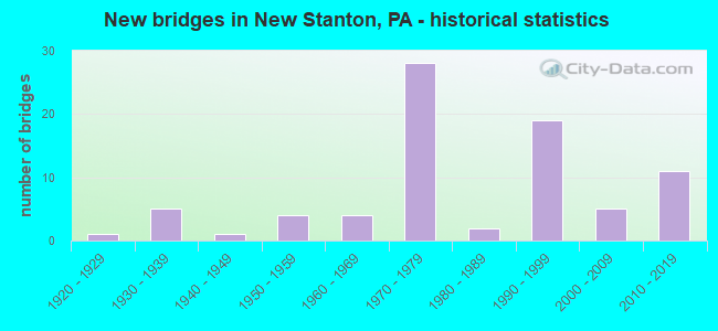
- New bridges - historical statistics
- 11920-1929
- 51930-1939
- 11940-1949
- 41950-1959
- 41960-1969
- 281970-1979
- 21980-1989
- 191990-1999
- 52000-2009
- 112010-2019

- Reconstructed bridges - Historical Statistics
- 31980-1989
- 21990-1999
- 12000-2009
- 12010-2019


- Bridge Condition - Deck
- 13.9%Very good
- 41.7%Good
- 25.0%Satisfactory
- 13.9%Fair
- 2.8%Poor
- 2.8%Serious

- Bridge Condition - Superstructure
- 18.4%Very good
- 26.3%Good
- 26.3%Satisfactory
- 21.1%Fair
- 7.9%Poor

- Bridge Condition - Substructure
- 21.1%Very good
- 31.6%Good
- 23.7%Satisfactory
- 21.1%Fair
- 2.6%Poor

- Bridge Condition - Channel
- 20.0%Very good
- 28.0%Good
- 24.0%Satisfactory
- 20.0%Fair
- 8.0%Poor

- Bridge Condition - Culverts
- 16.7%Very good
- 66.7%Satisfactory
- 16.7%Fair
Find on map >> Show street view
Structure Number: 45926, Location: 0.6 mi S of SR 3071 (Lat: 40.242983, Lng: -79.636300), Route carried "on" structure: State highway , Year Built: 2009, Status: Open, Structure Length: 9.85m (32.32ft), Average Daily Traffic: 499 (year 2020), Truck Traffic: 18%, Average Future Daily Traffic: 389 (year 2032), Design Load: HL 93, Features Intersected: PA Turnpike (MP 73.11), Facility Carried by Structure: SR 3075
Minimum Vertical Clearance: 30+ m (98+ ft), Kilometerpoint: 2.812, Lanes on structure: 2, Lanes under structure: 6, Owner: State Highway Agency, Approaching Roadway Width: 7.9m (25.9ft), Skew: 1 degrees, Material/Design: Prestressed concrete continuous, Design/Construction: Stringer/Multi-beam, Number Of Spans In Main Unit: 3, Length of Maximum Span: 41.8m (137.1ft), Curb or Sidewalk Widths: Left: 0.1m (0.3ft), Right: 0.1m (0.3ft), Curb-To-Curb Width: 10.4m (34.1ft), Out-to-Out Width: 11.4m (37.4ft)
Condition: Deck: Good, Superstructure: Very good, Substructure: Very good, Operating Rating: 76.2 metric tons, Method Used To Determine Operating Rating: Load and Resistance Factor (LRFR), Inventory Rating: 47.2 metric tons, Method Used To Determine Inventory Rating: Load and Resistance Factor (LRFR), Structural Evaluation: Equal to present desirable criteria, Deck Geometry: Equal to present minimum criteria, Underclear: Superior to present desirable criteria, Approach Roadway Alignment: Equal to present desirable criteria, Designated Inspection Frequency: Every 48 months, Inspection Date: May 2018, Deck Structure Type: Concrete Cast-file-Place, Wearing Surface/Protective System: Wearing Surface: Monolithic Concrete, Deck Protection: Epoxy Coated Reinforcing
Find on map >> Show street view
Structure Number: 46825, Location: 0.4 mi N from SR 0031 (Lat: 40.178581, Lng: -79.612703), Route carried "on" structure: State highway , Year Built: 2011, Status: Open, Structure Length: 0.73m (2.40ft), Average Daily Traffic: 1,536 (year 2020), Truck Traffic: 2%, Average Future Daily Traffic: 2,075 (year 2032), Design Load: HL 93, Features Intersected: Buffalo Run, Facility Carried by Structure: SR 3089
Minimum Vertical Clearance: 30+ m (98+ ft), Kilometerpoint: 8.119, Lanes on structure: 2, Owner: State Highway Agency, Approaching Roadway Width: 9.1m (29.9ft), Skew: 3 degrees, Material/Design: Concrete, Design/Construction: Culvert, Number Of Spans In Main Unit: 1, Length of Maximum Span: 6.7m (22.0ft), Curb-To-Curb Width: 9.1m (29.9ft), Out-to-Out Width: 16.8m (55.1ft)
Condition: Channel: Good, Culverts: Very good, Operating Rating: 57.7 metric tons, Method Used To Determine Operating Rating: Assigned ratings based on Load and Resistance Factor Design (LRFD) reported by rating factor (RF) using HL93 loadings, Inventory Rating: 36.3 metric tons, Method Used To Determine Inventory Rating: Assigned ratings based on Load and Resistance Factor Design (LRFD) reported by rating factor (RF) using HL93 loadings, Structural Evaluation: Equal to present desirable criteria, Deck Geometry: Somewhat better than minimum adequacy, Waterway Adequacy: Better than present minimum criteria, Approach Roadway Alignment: Equal to present desirable criteria, Designated Inspection Frequency: Every 24 months, Inspection Date: Febuary 2020
Find on map >> Show street view
Structure Number: 4791, Location: 4.6 mi E from SR 0031 (Lat: 40.215922, Lng: -79.629231), Route carried "on" structure: Interstate 70, Year Built: 2013, Status: Open, Structure Length: 3.05m (10.01ft), Average Daily Traffic: 18,339 (year 2022), Truck Traffic: 40%, Average Future Daily Traffic: 20,000 (year 2036), Design Load: HL 93, Features Intersected: SR 3014
Minimum Vertical Clearance: 30+ m (98+ ft), Kilometerpoint: 23.910, Lanes on structure: 2, Lanes under structure: 2, Base Highway Network: Yes, Owner: State Highway Agency, Approaching Roadway Width: 9.8m (32.2ft), Skew: 34 degrees, Material/Design: Prestressed concrete, Design/Construction: Stringer/Multi-beam, Number Of Spans In Main Unit: 1, Length of Maximum Span: 29.6m (97.1ft), Curb or Sidewalk Widths: Left: 0.1m (0.3ft), Right: 0.1m (0.3ft), Curb-To-Curb Width: 14.0m (45.9ft), Out-to-Out Width: 15.1m (49.5ft)
Condition: Deck: Very good, Superstructure: Very good, Substructure: Very good, Operating Rating: 67.4 metric tons, Method Used To Determine Operating Rating: Assigned ratings based on Load and Resistance Factor Design (LRFD) reported by rating factor (RF) using HL93 loadings, Inventory Rating: 42.4 metric tons, Method Used To Determine Inventory Rating: Assigned ratings based on Load and Resistance Factor Design (LRFD) reported by rating factor (RF) using HL93 loadings, Structural Evaluation: Equal to present desirable criteria, Deck Geometry: Superior to present desirable criteria, Underclear: Equal to present minimum criteria, Approach Roadway Alignment: Equal to present desirable criteria, Designated Inspection Frequency: Every 48 months, Inspection Date: May 2021, Deck Structure Type: Concrete Cast-file-Place, Wearing Surface/Protective System: Wearing Surface: Monolithic Concrete, Deck Protection: Epoxy Coated Reinforcing
Find on map >> Show street view
Structure Number: 47911, Location: 4.6 mi E from SR 0031 (Lat: 40.216011, Lng: -79.629278), Route carried "on" structure: Interstate 70, Year Built: 2013, Status: Open, Structure Length: 3.05m (10.01ft), Average Daily Traffic: 18,545 (year 2022), Truck Traffic: 39%, Average Future Daily Traffic: 20,000 (year 2036), Design Load: HL 93, Features Intersected: SR 3014
Minimum Vertical Clearance: 30+ m (98+ ft), Kilometerpoint: 23.942, Lanes on structure: 2, Lanes under structure: 2, Base Highway Network: Yes, Owner: State Highway Agency, Approaching Roadway Width: 10.1m (33.1ft), Skew: 34 degrees, Material/Design: Prestressed concrete, Design/Construction: Stringer/Multi-beam, Number Of Spans In Main Unit: 1, Length of Maximum Span: 29.6m (97.1ft), Curb or Sidewalk Widths: Left: 0.1m (0.3ft), Right: 0.1m (0.3ft), Curb-To-Curb Width: 12.2m (40.0ft), Out-to-Out Width: 13.2m (43.3ft)
Condition: Deck: Very good, Superstructure: Good, Substructure: Very good, Operating Rating: 67.4 metric tons, Method Used To Determine Operating Rating: Assigned ratings based on Load and Resistance Factor Design (LRFD) reported by rating factor (RF) using HL93 loadings, Inventory Rating: 42.4 metric tons, Method Used To Determine Inventory Rating: Assigned ratings based on Load and Resistance Factor Design (LRFD) reported by rating factor (RF) using HL93 loadings, Structural Evaluation: Better than present minimum criteria, Deck Geometry: Better than present minimum criteria, Underclear: Equal to present minimum criteria, Approach Roadway Alignment: Equal to present desirable criteria, Designated Inspection Frequency: Every 48 months, Inspection Date: May 2021, Deck Structure Type: Concrete Cast-file-Place, Wearing Surface/Protective System: Wearing Surface: Monolithic Concrete, Deck Protection: Epoxy Coated Reinforcing
Find on map >> Show street view
Structure Number: 5372, Location: 5.5 mi E from SR 0031 (Lat: 40.216722, Lng: -79.612708), Route carried "on" structure: Interstate 70, Year Built: 2016, Status: Open, Structure Length: 3.75m (12.30ft), Average Daily Traffic: 36,884 (year 2022), Truck Traffic: 40%, Average Future Daily Traffic: 39,332 (year 2036), Design Load: HL 93, Features Intersected: SR 3089
Minimum Vertical Clearance: 30+ m (98+ ft), Kilometerpoint: 25.521, Lanes on structure: 2, Lanes under structure: 2, Base Highway Network: Yes, Owner: State Highway Agency, Approaching Roadway Width: 14.9m (48.9ft), Skew: 31 degrees, Material/Design: Prestressed concrete, Design/Construction: Stringer/Multi-beam, Number Of Spans In Main Unit: 1, Length of Maximum Span: 36.6m (120.1ft), Curb or Sidewalk Widths: Left: 0.1m (0.3ft), Right: 0.1m (0.3ft), Curb-To-Curb Width: 24.4m (80.1ft), Out-to-Out Width: 26.2m (86.0ft)
Condition: Deck: Good, Superstructure: Very good, Substructure: Very good, Operating Rating: 55.1 metric tons, Method Used To Determine Operating Rating: Assigned ratings based on Load and Resistance Factor Design (LRFD) reported by rating factor (RF) using HL93 loadings, Inventory Rating: 38.2 metric tons, Method Used To Determine Inventory Rating: Assigned ratings based on Load and Resistance Factor Design (LRFD) reported by rating factor (RF) using HL93 loadings, Structural Evaluation: Equal to present desirable criteria, Deck Geometry: Superior to present desirable criteria, Underclear: Superior to present desirable criteria, Approach Roadway Alignment: Equal to present desirable criteria, Designated Inspection Frequency: Every 48 months, Inspection Date: May 2021, Deck Structure Type: Concrete Cast-file-Place, Wearing Surface/Protective System: Wearing Surface: Monolithic Concrete, Deck Protection: Epoxy Coated Reinforcing
Find on map >> Show street view
Structure Number: 54398, Location: over SR 0070 (Lat: 40.217444, Lng: -79.608528), Route carried "on" structure: State highway , Year Built: 2017, Status: Open, Structure Length: 5.12m (16.80ft), Average Daily Traffic: 7,095 (year 2022), Truck Traffic: 5%, Average Future Daily Traffic: 8,700 (year 2036), Design Load: HL 93, Features Intersected: SR 0070, Facility Carried by Structure: SR 3093
Minimum Vertical Clearance: 30+ m (98+ ft), Kilometerpoint: 9.270, Lanes on structure: 3, Lanes under structure: 6, Owner: State Highway Agency, Approaching Roadway Width: 11.3m (37.1ft), Skew: 1 degrees, Material/Design: Steel, Design/Construction: Stringer/Multi-beam, Number Of Spans In Main Unit: 1, Length of Maximum Span: 50.3m (165.0ft), Curb or Sidewalk Widths: Left: 1.7m (5.6ft), Right: 0.1m (0.3ft), Curb-To-Curb Width: 11.3m (37.1ft), Out-to-Out Width: 13.8m (45.3ft)
Condition: Deck: Very good, Superstructure: Very good, Substructure: Very good, Operating Rating: 54.8 metric tons, Method Used To Determine Operating Rating: Assigned ratings based on Load and Resistance Factor Design (LRFD) reported by rating factor (RF) using HL93 loadings, Inventory Rating: 42.1 metric tons, Method Used To Determine Inventory Rating: Assigned ratings based on Load and Resistance Factor Design (LRFD) reported by rating factor (RF) using HL93 loadings, Structural Evaluation: Equal to present desirable criteria, Deck Geometry: High priority of replacement, Underclear: Equal to present minimum criteria, Approach Roadway Alignment: Equal to present desirable criteria, Designated Inspection Frequency: Every 48 months, Inspection Date: May 2021, Deck Structure Type: Concrete Cast-file-Place, Wearing Surface/Protective System: Wearing Surface: Monolithic Concrete, Deck Protection: Epoxy Coated Reinforcing
Find on map >> Show street view
Structure Number: 36079, Location: HEMPFIELD TOWNSHIP (Lat: 40.212364, Lng: -79.590089), Route carried "under" structure: Interstate 76, Year Built: 1975, Structure Length: 0. m, Average Daily Traffic: 32,982 (year 2001), Truck Traffic: 36%, Features Intersected: T`PIKE, T-547 & WILSON R, Facility Carried by Structure: SR 0119
Minimum Vertical Clearance: 5.05m (16.57ft), Kilometerpoint: 0.000, Lanes on structure: 2, Lanes under structure: 4, Toll: On toll road, Material/Design: Steel continuous, Design/Construction: Stringer/Multi-beam, Length of Maximum Span: 50.9m (167.0ft)
Find on map >> Show street view
Structure Number: 36079, Location: HEMPFIELD TOWNSHIP (Lat: 40.212364, Lng: -79.590089), Route carried "under" structure: City street T547, Year Built: 1975, Structure Length: 0. m, Average Daily Traffic: 100 (year 2003), Truck Traffic: 1%, Features Intersected: T`PIKE, T-547 & WILSON R, Facility Carried by Structure: SR 0119
Minimum Vertical Clearance: 8.53m (27.99ft), Kilometerpoint: 0.000, Lanes on structure: 2, Lanes under structure: 2, Material/Design: Steel continuous, Design/Construction: Stringer/Multi-beam, Length of Maximum Span: 50.9m (167.0ft)
Find on map >> Show street view
Structure Number: 36081, Location: HEMPFIELD TOWNSHIP (Lat: 40.212178, Lng: -79.590328), Route carried "under" structure: Interstate 76, Year Built: 1975, Structure Length: 0. m, Average Daily Traffic: 32,982 (year 2001), Truck Traffic: 36%, Features Intersected: T`PIKE, T-547 & WILSON R, Facility Carried by Structure: SR 0119
Minimum Vertical Clearance: 5.05m (16.57ft), Kilometerpoint: 0.000, Lanes on structure: 2, Lanes under structure: 4, Material/Design: Steel continuous, Design/Construction: Stringer/Multi-beam, Length of Maximum Span: 50.9m (167.0ft)
Find on map >> Show street view
Structure Number: 36081, Location: HEMPFIELD TOWNSHIP (Lat: 40.212178, Lng: -79.590328), Route carried "under" structure: City street T547, Year Built: 1975, Structure Length: 0. m, Average Daily Traffic: 100 (year 2003), Truck Traffic: 1%, Features Intersected: T`PIKE, T-547 & WILSON R, Facility Carried by Structure: SR 0119
Minimum Vertical Clearance: 9.14m (29.99ft), Kilometerpoint: 0.000, Lanes on structure: 2, Lanes under structure: 6, Material/Design: Steel continuous, Design/Construction: Stringer/Multi-beam, Length of Maximum Span: 50.9m (167.0ft)
Find on map >> Show street view
Structure Number: 36082, Location: NEW STANTON BOROUGH (Lat: 40.220447, Lng: -79.591878), Route carried "under" structure: City street , Year Built: 1977, Structure Length: 0. m, Average Daily Traffic: 200 (year 2003), Truck Traffic: 5%, Features Intersected: TWP. THERMAL ROAD, Facility Carried by Structure: SR 0119
Minimum Vertical Clearance: 4.82m (15.81ft), Kilometerpoint: 0.000, Lanes on structure: 3, Lanes under structure: 2, Material/Design: Prestressed concrete, Design/Construction: Stringer/Multi-beam, Length of Maximum Span: 24.4m (80.1ft)
Find on map >> Show street view
Structure Number: 36084, Location: NEW STANTON BOROUGH (Lat: 40.219858, Lng: -79.592178), Route carried "under" structure: City street , Year Built: 1977, Structure Length: 0. m, Average Daily Traffic: 200 (year 2005), Truck Traffic: 5%, Features Intersected: TWP. THERMAL ROAD, Facility Carried by Structure: SR 0119
Minimum Vertical Clearance: 7.22m (23.69ft), Kilometerpoint: 0.000, Lanes on structure: 3, Lanes under structure: 2, Material/Design: Prestressed concrete, Design/Construction: Stringer/Multi-beam, Length of Maximum Span: 26.2m (86.0ft)
Find on map >> Show street view
Structure Number: 36086, Location: NEW STANTON BOROUGH (Lat: 40.225447, Lng: -79.593789), Route carried "under" structure: State highway , Year Built: 1977, Structure Length: 0. m, Average Daily Traffic: 12,802 (year 2021), Truck Traffic: 16%, Features Intersected: SR 3091, SR 0119, Facility Carried by Structure: SR 0119
Minimum Vertical Clearance: 4.57m (14.99ft), Kilometerpoint: 0.227, Lanes on structure: 3, Lanes under structure: 6, Material/Design: Steel, Design/Construction: Stringer/Multi-beam, Length of Maximum Span: 36.9m (121.1ft)
Find on map >> Show street view
Structure Number: 36086, Location: NEW STANTON BOROUGH (Lat: 40.225447, Lng: -79.593789), Route carried "under" structure: US 119, Year Built: 1977, Structure Length: 0. m, Average Daily Traffic: 14,448 (year 2022), Truck Traffic: 7%, Features Intersected: SR 3091, SR 0119
Minimum Vertical Clearance: 4.57m (14.99ft), Kilometerpoint: 13.575, Lanes on structure: 3, Lanes under structure: 6, Material/Design: Steel, Design/Construction: Stringer/Multi-beam, Length of Maximum Span: 36.9m (121.1ft)
Find on map >> Show street view
Structure Number: 36086, Location: NEW STANTON BOROUGH (Lat: 40.225447, Lng: -79.593789), Route carried "under" structure: State highway , Year Built: 1977, Structure Length: 0. m, Average Daily Traffic: 12,964 (year 2021), Truck Traffic: 19%, Features Intersected: SR 3091, SR 0119, Facility Carried by Structure: SR 0119
Minimum Vertical Clearance: 4.57m (14.99ft), Kilometerpoint: 0.230, Lanes on structure: 3, Lanes under structure: 6, Material/Design: Steel, Design/Construction: Stringer/Multi-beam, Length of Maximum Span: 36.9m (121.1ft)
Find on map >> Show street view
Structure Number: 36086, Location: NEW STANTON BOROUGH (Lat: 40.225447, Lng: -79.593789), Route carried "under" structure: US 119, Year Built: 1977, Structure Length: 0. m, Average Daily Traffic: 14,702 (year 2022), Truck Traffic: 6%, Features Intersected: SR 3091, SR 0119
Minimum Vertical Clearance: 4.57m (14.99ft), Kilometerpoint: 13.518, Lanes on structure: 3, Lanes under structure: 6, Material/Design: Steel, Design/Construction: Stringer/Multi-beam, Length of Maximum Span: 36.9m (121.1ft)
Find on map >> Show street view
Structure Number: 36664, Location: NEW STANTON BOROUGH (Lat: 40.215325, Lng: -79.606539), Route carried "under" structure: ServiceCity street , Year Built: 1950, Structure Length: 0. m, Average Daily Traffic: 200 (year 2004), Truck Traffic: 5%, Features Intersected: SW PA R/R, RD, SEWICKLEY, Facility Carried by Structure: SR 3093
Minimum Vertical Clearance: 4.60m (15.09ft), Kilometerpoint: 0.000, Lanes on structure: 2, Lanes under structure: 1, Material/Design: Steel continuous, Design/Construction: Stringer/Multi-beam, Length of Maximum Span: 27.4m (89.9ft)
Find on map >> Show street view
Structure Number: 36668, Location: HEMPFIELD TOWNSHIP (Lat: 40.218333, Lng: -79.578333), Route carried "under" structure: US 119, Year Built: 1977, Structure Length: 0. m, Average Daily Traffic: 11,266 (year 2022), Truck Traffic: 13%, Features Intersected: SR 0119, Facility Carried by Structure: SR 3095
Minimum Vertical Clearance: 5.31m (17.42ft), Kilometerpoint: 10.371, Lanes on structure: 2, Lanes under structure: 4, Material/Design: Steel continuous, Design/Construction: Stringer/Multi-beam, Length of Maximum Span: 32.0m (105.0ft)
Find on map >> Show street view
Structure Number: 36668, Location: HEMPFIELD TOWNSHIP (Lat: 40.218333, Lng: -79.578333), Route carried "under" structure: US 119, Year Built: 1977, Structure Length: 0. m, Average Daily Traffic: 11,606 (year 2022), Truck Traffic: 14%, Features Intersected: SR 0119, Facility Carried by Structure: SR 3095
Minimum Vertical Clearance: 5.18m (16.99ft), Kilometerpoint: 10.404, Lanes on structure: 2, Lanes under structure: 4, Material/Design: Steel continuous, Design/Construction: Stringer/Multi-beam, Length of Maximum Span: 32.0m (105.0ft)
Find on map >> Show street view
Structure Number: 36782, Location: NEW STANTON BOROUGH (Lat: 40.221667, Lng: -79.595000), Route carried "under" structure: US 119, Year Built: 1977, Structure Length: 0. m, Average Daily Traffic: 14,448 (year 2022), Truck Traffic: 7%, Features Intersected: SR 0119, Facility Carried by Structure: PA TPK (PA-66)
Minimum Vertical Clearance: 6.14m (20.14ft), Kilometerpoint: 13.575, Lanes on structure: 3, Lanes under structure: 6, Material/Design: Steel, Design/Construction: Stringer/Multi-beam, Length of Maximum Span: 36.9m (121.1ft)
Find on map >> Show street view
Structure Number: 36782, Location: NEW STANTON BOROUGH (Lat: 40.221667, Lng: -79.595000), Route carried "under" structure: US 119, Year Built: 1977, Structure Length: 0. m, Average Daily Traffic: 14,702 (year 2022), Truck Traffic: 6%, Features Intersected: SR 0119, Facility Carried by Structure: PA TPK (PA-66)
Minimum Vertical Clearance: 5.75m (18.86ft), Kilometerpoint: 13.518, Lanes on structure: 3, Lanes under structure: 6, Material/Design: Steel, Design/Construction: Stringer/Multi-beam, Length of Maximum Span: 36.9m (121.1ft)
Find on map >> Show street view
Structure Number: 36783, Location: NEW STANTON BOROUGH (Lat: 40.233061, Lng: -79.601408), Route carried "under" structure: Other road 66, Year Built: 1991, Structure Length: 0. m, Average Daily Traffic: 15,194 (year 2008), Truck Traffic: 15%, Features Intersected: PA TPK (PA-66), Facility Carried by Structure: T-682
Minimum Vertical Clearance: 5.18m (16.99ft), Kilometerpoint: 0.000, Lanes on structure: 2, Lanes under structure: 6, Material/Design: Steel continuous, Design/Construction: Stringer/Multi-beam, Length of Maximum Span: 40.8m (133.9ft)
Find on map >> Show street view
Structure Number: 36786, Location: HEMPFIELD TWP (Lat: 40.256803, Lng: -79.612903), Route carried "under" structure: State highway , Year Built: 1991, Structure Length: 0. m, Average Daily Traffic: 639 (year 2020), Truck Traffic: 3%, Features Intersected: SR 2012, Facility Carried by Structure: PA TPK (PA 66)
Minimum Vertical Clearance: 9.95m (32.64ft), Kilometerpoint: 0.000, Lanes on structure: 2, Lanes under structure: 2, Material/Design: Steel continuous, Design/Construction: Stringer/Multi-beam, Length of Maximum Span: 30.5m (100.1ft)
Find on map >> Show street view
Structure Number: 36787, Location: HEMPFIELD TWP (Lat: 40.255000, Lng: -79.610000), Route carried "under" structure: State highway , Year Built: 1991, Structure Length: 0. m, Average Daily Traffic: 639 (year 2020), Truck Traffic: 3%, Features Intersected: SR 2012, Facility Carried by Structure: PA TPK (PA 66)
Minimum Vertical Clearance: 10.53m (34.55ft), Kilometerpoint: 0.000, Lanes on structure: 2, Lanes under structure: 2, Material/Design: Steel continuous, Design/Construction: Stringer/Multi-beam, Length of Maximum Span: 30.5m (100.1ft)
Find on map >> Show street view
Structure Number: 36788, Location: HEMPFIELD TWP (Lat: 40.265536, Lng: -79.614708), Route carried "under" structure: State highway 66, Year Built: 1991, Structure Length: 0. m, Average Daily Traffic: 10,429 (year 1998), Truck Traffic: 15%, Features Intersected: Tpk 66 MP G003.05 GB-110, Facility Carried by Structure: SR 3016
Minimum Vertical Clearance: 7.09m (23.26ft), Kilometerpoint: 0.000, Lanes on structure: 2, Lanes under structure: 4, Material/Design: Steel continuous, Design/Construction: Stringer/Multi-beam, Length of Maximum Span: 45.7m (149.9ft)
Find on map >> Show street view
Structure Number: 36839, Location: NEW STANTON INTERCHANGE (Lat: 40.216667, Lng: -79.583333), Route carried "under" structure: Interstate 76, Year Built: 1997, Structure Length: 0. m, Average Daily Traffic: 34,232 (year 2004), Truck Traffic: 32%, Features Intersected: PA TPK (I-76), Facility Carried by Structure: PA TPK (RAMP AB)
Minimum Vertical Clearance: 4.84m (15.88ft), Kilometerpoint: 0.000, Lanes on structure: 2, Lanes under structure: 4, Toll: On toll road, Material/Design: Steel, Design/Construction: Stringer/Multi-beam, Length of Maximum Span: 32.3m (106.0ft)
Find on map >> Show street view
Structure Number: 3684, Location: NEW STANTON (Lat: 40.216667, Lng: -79.586667), Route carried "under" structure: State highway 3093, Year Built: 1939, Structure Length: 0. m, Average Daily Traffic: 200 (year 1992), Features Intersected: SR 3093, Facility Carried by Structure: PA TPK (I-76)
Minimum Vertical Clearance: 4.56m (14.96ft), Kilometerpoint: 0.000, Lanes on structure: 5, Lanes under structure: 2, Material/Design: Prestressed concrete, Design/Construction: Box Beam or Girders - Single/Spread, Length of Maximum Span: 11.3m (37.1ft)
Find on map >> Show street view
Structure Number: 36842, Location: NEAR NEW STANTON (Lat: 40.217897, Lng: -79.600214), Route carried "under" structure: Interstate 70, Year Built: 1999, Structure Length: 0. m, Average Daily Traffic: 20,850 (year 2022), Truck Traffic: 24%, Features Intersected: SR 0070, RR & SEWICKLEY, Facility Carried by Structure: PA TPK (I-76)
Minimum Vertical Clearance: 5.18m (16.99ft), Kilometerpoint: 26.268, Lanes on structure: 2, Lanes under structure: 4, Material/Design: Steel continuous, Design/Construction: Stringer/Multi-beam, Length of Maximum Span: 42.7m (140.1ft)
Find on map >> Show street view
Structure Number: 36842, Location: NEAR NEW STANTON (Lat: 40.217897, Lng: -79.600214), Route carried "under" structure: State highway , Year Built: 1999, Structure Length: 0. m, Average Daily Traffic: 12,964 (year 2021), Truck Traffic: 19%, Features Intersected: SR 0070, RR & SEWICKLEY, Facility Carried by Structure: PA TPK (I-76)
Minimum Vertical Clearance: 5.44m (17.85ft), Kilometerpoint: 0.000, Lanes on structure: 2, Lanes under structure: 4, Material/Design: Steel continuous, Design/Construction: Stringer/Multi-beam, Length of Maximum Span: 42.7m (140.1ft)
Find on map >> Show street view
Structure Number: 36842, Location: NEAR NEW STANTON (Lat: 40.217897, Lng: -79.600214), Route carried "under" structure: State highway , Year Built: 1999, Structure Length: 0. m, Average Daily Traffic: 12,802 (year 2021), Truck Traffic: 16%, Features Intersected: SR 0070, RR & SEWICKLEY, Facility Carried by Structure: PA TPK (I-76)
Minimum Vertical Clearance: 5.44m (17.85ft), Kilometerpoint: 0.000, Lanes on structure: 2, Lanes under structure: 4, Material/Design: Steel continuous, Design/Construction: Stringer/Multi-beam, Length of Maximum Span: 42.7m (140.1ft)
Find on map >> Show street view
Structure Number: 36842, Location: NEAR NEW STANTON (Lat: 40.217897, Lng: -79.600214), Route carried "under" structure: Interstate 70, Year Built: 1999, Structure Length: 0. m, Average Daily Traffic: 20,767 (year 2022), Truck Traffic: 24%, Features Intersected: SR 0070, RR & SEWICKLEY, Facility Carried by Structure: PA TPK (I-76)
Minimum Vertical Clearance: 5.18m (16.99ft), Kilometerpoint: 26.302, Lanes on structure: 2, Lanes under structure: 4, Material/Design: Steel continuous, Design/Construction: Stringer/Multi-beam, Length of Maximum Span: 42.7m (140.1ft)
Find on map >> Show street view
Structure Number: 36843, Location: EAST OF NEW STANTON (Lat: 40.213333, Lng: -79.591667), Route carried "under" structure: Interstate 76, Year Built: 1997, Structure Length: 0. m, Average Daily Traffic: 34,232 (year 2004), Truck Traffic: 32%, Features Intersected: PA TPK (I-76), Facility Carried by Structure: T-549, Thermo Vill
Minimum Vertical Clearance: 5.07m (16.63ft), Kilometerpoint: 0.000, Lanes on structure: 2, Lanes under structure: 4, Material/Design: Steel, Design/Construction: Stringer/Multi-beam, Length of Maximum Span: 45.7m (149.9ft)
Find on map >> Show street view
Structure Number: 36844, Location: NEW STANTON REST AREA (Lat: 40.205000, Lng: -79.575000), Route carried "under" structure: Interstate 76, Year Built: 1939, Structure Length: 0. m, Average Daily Traffic: 32,982 (year 2001), Truck Traffic: 36%, Features Intersected: PA TPK (I-76), Facility Carried by Structure: T-680, Sportsman
Minimum Vertical Clearance: 4.70m (15.42ft), Kilometerpoint: 0.000, Lanes on structure: 2, Lanes under structure: 4, Material/Design: Steel, Design/Construction: Stringer/Multi-beam, Length of Maximum Span: 37.8m (124.0ft)
Find on map >> Show street view
Structure Number: 37044, Location: NEW STANTON BOROUGH (Lat: 40.220000, Lng: -79.598333), Route carried "under" structure: State highway , Year Built: 1964, Structure Length: 0. m, Average Daily Traffic: 12,964 (year 2021), Truck Traffic: 19%, Features Intersected: SR 3091, Facility Carried by Structure: PA TPK (RAMP EF)
Minimum Vertical Clearance: 4.43m (14.53ft), Kilometerpoint: 0.230, Lanes on structure: 2, Lanes under structure: 3, Material/Design: Steel, Design/Construction: Stringer/Multi-beam, Length of Maximum Span: 24.7m (81.0ft)
Find on map >> Show street view
Structure Number: 37044, Location: NEW STANTON BOROUGH (Lat: 40.220000, Lng: -79.598333), Route carried "under" structure: State highway , Year Built: 1964, Structure Length: 0. m, Average Daily Traffic: 12,802 (year 2021), Truck Traffic: 16%, Features Intersected: SR 3091, Facility Carried by Structure: PA TPK (RAMP EF)
Minimum Vertical Clearance: 4.80m (15.75ft), Kilometerpoint: 0.227, Lanes on structure: 2, Lanes under structure: 2, Material/Design: Steel, Design/Construction: Stringer/Multi-beam, Length of Maximum Span: 24.7m (81.0ft)
Find on map >> Show street view
Structure Number: 45375, Location: NEAR OLD STANTON (Lat: 40.226667, Lng: -79.620000), Route carried "under" structure: Interstate 76, Year Built: 2008, Structure Length: 0. m, Average Daily Traffic: 35,080 (year 2008), Truck Traffic: 21%, Features Intersected: PA TPK (I-76), Facility Carried by Structure: T-541 GLENN FOX RD
Minimum Vertical Clearance: 5.14m (16.86ft), Kilometerpoint: 0.000, Lanes on structure: 2, Lanes under structure: 6, Toll: On toll road, Material/Design: Prestressed concrete, Design/Construction: Box Beam or Girders - Multiple, Length of Maximum Span: 30.5m (100.1ft)
Find on map >> Show street view
Structure Number: 4791, Location: 4.6 mi E from SR 0031 (Lat: 40.215922, Lng: -79.629231), Route carried "under" structure: State highway , Year Built: 2013, Structure Length: 0. m, Average Daily Traffic: 783 (year 2021), Truck Traffic: 10%, Features Intersected: SR 3014, Facility Carried by Structure: SR 0070
Minimum Vertical Clearance: 4.61m (15.12ft), Kilometerpoint: 3.209, Lanes on structure: 2, Lanes under structure: 2, Material/Design: Prestressed concrete, Design/Construction: Stringer/Multi-beam, Length of Maximum Span: 29.6m (97.1ft)
Find on map >> Show street view
Structure Number: 47911, Location: 4.6 mi E from SR 0031 (Lat: 40.216011, Lng: -79.629278), Route carried "under" structure: State highway , Year Built: 2013, Structure Length: 0. m, Average Daily Traffic: 783 (year 2021), Truck Traffic: 10%, Features Intersected: SR 3014, Facility Carried by Structure: SR 0070
Minimum Vertical Clearance: 4.61m (15.12ft), Kilometerpoint: 3.209, Lanes on structure: 2, Lanes under structure: 2, Material/Design: Prestressed concrete, Design/Construction: Stringer/Multi-beam, Length of Maximum Span: 29.6m (97.1ft)
Find on map >> Show street view
Structure Number: 5372, Location: 5.5 mi E from SR 0031 (Lat: 40.216722, Lng: -79.612708), Route carried "under" structure: State highway , Year Built: 2016, Structure Length: 0. m, Average Daily Traffic: 3,427 (year 2021), Truck Traffic: 18%, Features Intersected: SR 3089, Facility Carried by Structure: SR 0070
Minimum Vertical Clearance: 5.36m (17.59ft), Kilometerpoint: 12.788, Lanes on structure: 2, Lanes under structure: 1, Material/Design: Prestressed concrete, Design/Construction: Stringer/Multi-beam, Length of Maximum Span: 36.6m (120.1ft)
Find on map >> Show street view
Structure Number: 5372, Location: 5.5 mi E from SR 0031 (Lat: 40.216722, Lng: -79.612708), Route carried "under" structure: State highway , Year Built: 2016, Structure Length: 0. m, Average Daily Traffic: 2,852 (year 2021), Truck Traffic: 13%, Features Intersected: SR 3089, Facility Carried by Structure: SR 0070
Minimum Vertical Clearance: 5.36m (17.59ft), Kilometerpoint: 12.788, Lanes on structure: 2, Lanes under structure: 1, Material/Design: Prestressed concrete, Design/Construction: Stringer/Multi-beam, Length of Maximum Span: 36.6m (120.1ft)
Find on map >> Show street view
Structure Number: 54398, Location: over SR 0070 (Lat: 40.217444, Lng: -79.608528), Route carried "under" structure: Interstate 70, Year Built: 2017, Structure Length: 0. m, Average Daily Traffic: 20,850 (year 2022), Truck Traffic: 24%, Features Intersected: SR 0070, Facility Carried by Structure: SR 3093
Minimum Vertical Clearance: 5.03m (16.50ft), Kilometerpoint: 26.268, Lanes on structure: 3, Lanes under structure: 3, Material/Design: Steel, Design/Construction: Stringer/Multi-beam, Length of Maximum Span: 50.3m (165.0ft)
Find on map >> Show street view
Structure Number: 54398, Location: over SR 0070 (Lat: 40.217444, Lng: -79.608528), Route carried "under" structure: Interstate 70, Year Built: 2017, Structure Length: 0. m, Average Daily Traffic: 20,767 (year 2022), Truck Traffic: 24%, Features Intersected: SR 0070, Facility Carried by Structure: SR 3093
Minimum Vertical Clearance: 5.03m (16.50ft), Kilometerpoint: 26.302, Lanes on structure: 3, Lanes under structure: 3, Material/Design: Steel, Design/Construction: Stringer/Multi-beam, Length of Maximum Span: 50.3m (165.0ft)