Bridge Statistics for Norfolk, Virginia (VA)
Condition, Traffic, Stress, Structural Evaluation, Project Costs
- National Bridge Inventory (NBI) Statistics
- 390Number of bridges
- 8,819ft / 2,688mTotal length
- $232,892,000Total costs
- 12,462,950Total average daily traffic
- 315,148Total average daily truck traffic
- National Bridge Inventory (NBI) Registered Bridges for Norfolk
- No street view available for this location
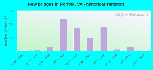
- New bridges - historical statistics
- 21930-1939
- 31940-1949
- 151950-1959
- 1191960-1969
- 861970-1979
- 511980-1989
- 901990-1999
- 62000-2009
- 162010-2019
- 22020-2022

- Reconstructed bridges - Historical Statistics
- 11970-1979
- 81980-1989
- 181990-1999
- 32000-2009
- 02010-2019
- 12020-2022


- Bridge Condition - Deck
- 2.7%Very good
- 30.6%Good
- 49.7%Satisfactory
- 16.9%Fair

- Bridge Condition - Superstructure
- 7.1%Very good
- 21.3%Good
- 46.4%Satisfactory
- 25.1%Fair

- Bridge Condition - Substructure
- 2.7%Very good
- 22.4%Good
- 39.9%Satisfactory
- 35.0%Fair

- Bridge Condition - Channel
- 27.8%Very good
- 44.4%Good
- 22.2%Satisfactory
- 5.6%Fair

- Bridge Condition - Culverts
- 50.0%Good
- 50.0%Satisfactory
Find on map >> Show street view
Structure Number: 1VALP79, Location: EAST OF I-564 AT 3RD AVE. (Lat: 36.938111, Lng: -76.301861), Route carried "on" structure: ServiceOther road , Year Built: 1952, Status: Open, Structure Length: 0.83m (2.72ft), Average Daily Traffic: 20 (year 2010), Truck Traffic: 10%, Average Future Daily Traffic: 25 (year 2040), Design Load: HS 20, Features Intersected: BOUSH CREEK, Facility Carried by Structure: PATROL ROAD
Minimum Vertical Clearance: 30+ m (98+ ft), Kilometerpoint: 0.000, Lanes on structure: 2, Owner: Navy/Marines, Approaching Roadway Width: 9.3m (30.5ft), Material/Design: Steel, Design/Construction: Stringer/Multi-beam, Number Of Spans In Main Unit: 1, Length of Maximum Span: 7.9m (25.9ft), Curb or Sidewalk Widths: Left: 0.3m (1.0ft), Right: 0.3m (1.0ft), Curb-To-Curb Width: 10.2m (33.5ft), Out-to-Out Width: 10.7m (35.1ft)
Condition: Deck: Satisfactory, Superstructure: Fair, Substructure: Satisfactory, Channel: Satisfactory, Operating Rating: 38.9 metric tons, Method Used To Determine Operating Rating: Load Factor (LF), Inventory Rating: 23.3 metric tons, Method Used To Determine Inventory Rating: Load Factor (LF), Structural Evaluation: Somewhat better than minimum adequacy, Deck Geometry: Superior to present desirable criteria, Waterway Adequacy: Equal to present desirable criteria, Approach Roadway Alignment: Equal to present desirable criteria, Length Of Structure Improvement: 0.83m (2.72ft), Designated Inspection Frequency: Every 24 months, Inspection Date: August 2020, Bridge Improvement Cost: $100,000, Roadway Improvement Cost: $24,000, Total Project Cost: $124,000 ( Estimate for 2020), Deck Structure Type: Concrete Cast-file-Place, Wearing Surface/Protective System: Wearing Surface: Monolithic Concrete
Find on map >> Show street view
Structure Number: 20764, Location: 0.17 fr Curlew/0.27 to 13 (Lat: 36.843158, Lng: -76.213211), Route carried "on" structure: ServiceCounty highway F135, Year Built: 1967, Status: Open, Structure Length: 9.20m (30.18ft), Average Daily Traffic: 4,125 (year 1989), Truck Traffic: 2%, Average Future Daily Traffic: 6,500 (year 2034), Design Load: HS 20+Mod, Features Intersected: IS 264 & Collector Roads, Facility Carried by Structure: Frontage Road
Minimum Vertical Clearance: 30+ m (98+ ft), Kilometerpoint: 0.000, Lanes on structure: 2, Lanes under structure: 16, Owner: State Highway Agency, Approaching Roadway Width: 8.5m (27.9ft), Material/Design: Prestressed concrete, Design/Construction: Stringer/Multi-beam, Number Of Spans In Main Unit: 6, Length of Maximum Span: 20.7m (67.9ft), Curb or Sidewalk Widths: Left: 0.5m (1.6ft), Right: 1.5m (4.9ft), Curb-To-Curb Width: 8.5m (27.9ft), Out-to-Out Width: 11.2m (36.7ft)
Condition: Deck: Good, Superstructure: Satisfactory, Substructure: Satisfactory, Operating Rating: 57.2 metric tons, Method Used To Determine Operating Rating: Load and Resistance Factor (LRFR), Inventory Rating: 40.8 metric tons, Method Used To Determine Inventory Rating: Load and Resistance Factor (LRFR), Structural Evaluation: Equal to present minimum criteria, Deck Geometry: Meets minimum limits, Underclear: High priority of corrective action, Approach Roadway Alignment: Equal to present desirable criteria, Designated Inspection Frequency: Every 24 months, Inspection Date: November 2020, Deck Structure Type: Concrete Cast-file-Place, Wearing Surface/Protective System: Wearing Surface: Epoxy Overlay, Membrane: Epoxy
Find on map >> Show street view
Structure Number: 20766, Location: 0.10THOLE ST/0.20DEAD END (Lat: 36.904036, Lng: -76.257681), Route carried "on" structure: ServiceCity street , Year Built: 1967, Status: Open, Structure Length: 1.04m (3.41ft), Average Daily Traffic: 200 (year 1990), Truck Traffic: 25%, Average Future Daily Traffic: 400 (year 2027), Design Load: HS 20+Mod, Features Intersected: N BR LAFAYETTE RIVER, Facility Carried by Structure: ROUTE 0000
Minimum Vertical Clearance: 30+ m (98+ ft), Kilometerpoint: 0.000, Lanes on structure: 2, Owner: City or Municipal Highway Agency, Approaching Roadway Width: 8.5m (27.9ft), Skew: 3 degrees, Material/Design: Concrete, Design/Construction: Culvert, Number Of Spans In Main Unit: 3, Length of Maximum Span: 3.0m (9.8ft)
Condition: Channel: Satisfactory, Culverts: Satisfactory, Operating Rating: 43.9 metric tons, Method Used To Determine Operating Rating: Load Factor (LF), Inventory Rating: 26.3 metric tons, Method Used To Determine Inventory Rating: Load Factor (LF), Structural Evaluation: Equal to present minimum criteria, Waterway Adequacy: Equal to present minimum criteria, Approach Roadway Alignment: Equal to present minimum criteria, Designated Inspection Frequency: Every 24 months, Inspection Date: Febuary 2021
Find on map >> Show street view
Structure Number: 20767, Location: 0.20 TO 165/ 0.30NOF APOR (Lat: 36.886878, Lng: -76.210300), Route carried "on" structure: City street , Year Built: 1944, Year Reconstructed: 1987, Status: Open, Structure Length: 2.93m (9.61ft), Average Daily Traffic: 9,300 (year 2012), Truck Traffic: 15%, Average Future Daily Traffic: 37,200 (year 2028), Design Load: HS 20, Features Intersected: NORFOLK WAT. SUPPLY CAN, Facility Carried by Structure: ROBIN HOOD ROAD
Minimum Vertical Clearance: 30+ m (98+ ft), Kilometerpoint: 0.000, Lanes on structure: 2, Owner: City or Municipal Highway Agency, Approaching Roadway Width: 11.0m (36.1ft), Skew: 3 degrees, Material/Design: Concrete continuous, Design/Construction: Tee Beam, Number Of Spans In Main Unit: 4, Length of Maximum Span: 7.3m (24.0ft), Curb or Sidewalk Widths: Left: 0.5m (1.6ft), Right: 0.5m (1.6ft), Curb-To-Curb Width: 7.9m (25.9ft), Out-to-Out Width: 9.6m (31.5ft)
Condition: Deck: Satisfactory, Superstructure: Fair, Substructure: Fair, Channel: Very good, Operating Rating: 89.8 metric tons, Method Used To Determine Operating Rating: Load and Resistance Factor (LRFR), Inventory Rating: 71.1 metric tons, Method Used To Determine Inventory Rating: Load and Resistance Factor (LRFR), Structural Evaluation: Somewhat better than minimum adequacy, Deck Geometry: High priority of replacement, Waterway Adequacy: Equal to present minimum criteria, Approach Roadway Alignment: Somewhat better than minimum adequacy, Length Of Structure Improvement: 3.05m (10.01ft), Designated Inspection Frequency: Every 24 months, Inspection Date: March 2020, Bridge Improvement Cost: $562,000, Roadway Improvement Cost: $56,000, Total Project Cost: $843,000, Deck Structure Type: Concrete Cast-file-Place, Wearing Surface/Protective System: Wearing Surface: Epoxy Overlay, Membrane: Epoxy
Find on map >> Show street view
Structure Number: 20768, Location: 00.27 MILES FROM RTE. 460 (Lat: 36.950392, Lng: -76.259325), Route carried "on" structure: City street , Year Built: 1958, Status: Open, Structure Length: 2.59m (8.50ft), Average Daily Traffic: 5,046 (year 2020), Truck Traffic: 2%, Average Future Daily Traffic: 5,067 (year 2040), Design Load: HS 20, Features Intersected: TIDEWATER DRIVE_(RTE.168, Facility Carried by Structure: 1ST VIEW STEET
Minimum Vertical Clearance: 30+ m (98+ ft), Kilometerpoint: 0.000, Lanes on structure: 2, Lanes under structure: 4, Owner: City or Municipal Highway Agency, Approaching Roadway Width: 16.5m (54.1ft), Skew: 4 degrees, Material/Design: Prestressed concrete, Design/Construction: Stringer/Multi-beam, Number Of Spans In Main Unit: 1, Length of Maximum Span: 25.9m (85.0ft), Curb or Sidewalk Widths: Left: 1.2m (3.9ft), Right: 1.2m (3.9ft), Curb-To-Curb Width: 11.0m (36.1ft), Out-to-Out Width: 14.0m (45.9ft)
Condition: Deck: Satisfactory, Superstructure: Satisfactory, Substructure: Satisfactory, Channel: Good, Operating Rating: 48.4 metric tons, Method Used To Determine Operating Rating: Load Factor (LF), Inventory Rating: 23.5 metric tons, Method Used To Determine Inventory Rating: Load Factor (LF), Structural Evaluation: Somewhat better than minimum adequacy, Deck Geometry: Meets minimum limits, Underclear: High priority of replacement, Approach Roadway Alignment: Equal to present minimum criteria, Length Of Structure Improvement: 3.05m (10.01ft), Designated Inspection Frequency: Every 24 months, Inspection Date: August 2020, Bridge Improvement Cost: $400,000, Roadway Improvement Cost: $40,000, Total Project Cost: $600,000, Deck Structure Type: Concrete Cast-file-Place, Wearing Surface/Protective System: Wearing Surface: Monolithic Concrete
Find on map >> Show street view
Structure Number: 2077, Location: 00.45 MILES FROM RTE. 460 (Lat: 36.953150, Lng: -76.258967), Route carried "on" structure: City street , Year Built: 1956, Status: Open, Structure Length: 2.04m (6.69ft), Average Daily Traffic: 7,519 (year 1990), Truck Traffic: 10%, Average Future Daily Traffic: 9,000 (year 2028), Design Load: HS 20, Features Intersected: TIDEWATER DRIVE (RTE.168, Facility Carried by Structure: GOVERNMT AVE.
Minimum Vertical Clearance: 30+ m (98+ ft), Kilometerpoint: 0.000, Lanes on structure: 2, Lanes under structure: 4, Owner: City or Municipal Highway Agency, Approaching Roadway Width: 10.4m (34.1ft), Skew: 1 degrees, Material/Design: Prestressed concrete, Design/Construction: Stringer/Multi-beam, Number Of Spans In Main Unit: 1, Length of Maximum Span: 20.4m (66.9ft), Curb or Sidewalk Widths: Left: 2.4m (7.9ft), Right: 2.4m (7.9ft), Curb-To-Curb Width: 9.8m (32.2ft), Out-to-Out Width: 15.2m (49.9ft)
Condition: Deck: Satisfactory, Superstructure: Satisfactory, Substructure: Good, Channel: Good, Operating Rating: 45.7 metric tons, Method Used To Determine Operating Rating: Load Factor (LF), Inventory Rating: 22.6 metric tons, Method Used To Determine Inventory Rating: Load Factor (LF), Structural Evaluation: Somewhat better than minimum adequacy, Deck Geometry: Meets minimum limits, Underclear: High priority of replacement, Approach Roadway Alignment: Equal to present minimum criteria, Length Of Structure Improvement: 3.05m (10.01ft), Designated Inspection Frequency: Every 24 months, Inspection Date: August 2020, Bridge Improvement Cost: $340,000, Roadway Improvement Cost: $34,000, Total Project Cost: $510,000, Deck Structure Type: Concrete Cast-file-Place, Wearing Surface/Protective System: Wearing Surface: Monolithic Concrete
Find on map >> Show street view
Structure Number: 20773, Location: 0.75 38TH ST/0.50 TO 337 (Lat: 36.890756, Lng: -76.295261), Route carried "on" structure: City street , Year Built: 1978, Status: Open, Structure Length: 15.30m (50.20ft), Average Daily Traffic: 6,825 (year 2020), Truck Traffic: 1%, Average Future Daily Traffic: 9,300 (year 2040), Design Load: HS 20+Mod, Features Intersected: Colley Bay, Facility Carried by Structure: Colley Avenue
Minimum Vertical Clearance: 30+ m (98+ ft), Kilometerpoint: 0.000, Lanes on structure: 2, Owner: City or Municipal Highway Agency, Approaching Roadway Width: 11.0m (36.1ft), Material/Design: Prestressed concrete, Design/Construction: Stringer/Multi-beam, Number Of Spans In Main Unit: 8, Length of Maximum Span: 18.9m (62.0ft), Curb or Sidewalk Widths: Left: 1.5m (4.9ft), Right: 1.5m (4.9ft), Curb-To-Curb Width: 11.0m (36.1ft), Out-to-Out Width: 14.6m (47.9ft)
Condition: Deck: Satisfactory, Superstructure: Fair, Substructure: Satisfactory, Channel: Satisfactory, Operating Rating: 89.8 metric tons, Method Used To Determine Operating Rating: Load and Resistance Factor (LRFR), Inventory Rating: 70.7 metric tons, Method Used To Determine Inventory Rating: Load and Resistance Factor (LRFR), Structural Evaluation: Somewhat better than minimum adequacy, Deck Geometry: Meets minimum limits, Waterway Adequacy: Equal to present desirable criteria, Approach Roadway Alignment: Equal to present desirable criteria, Designated Inspection Frequency: Every 24 months, Underwater Inspection Frequency: Every 60 months, Inspection Date: June 2021, Underwater Inspection Date: March 2021, Deck Structure Type: Concrete Precast Panels, Wearing Surface/Protective System: Wearing Surface: Monolithic Concrete
Find on map >> Show street view
Structure Number: 20774, Location: Ramp to Tidewater Drive (Lat: 36.844594, Lng: -76.279283), Route carried "on" structure: Ramp State highway 337, Year Built: 1972, Year Reconstructed: 1990, Status: Open, Structure Length: 6.86m (22.51ft), Average Daily Traffic: 12,015 (year 2018), Truck Traffic: 4%, Average Future Daily Traffic: 7,000 (year 2035), Design Load: HS 20+Mod, Features Intersected: Adj to Mainline Br 2858
Minimum Vertical Clearance: 30+ m (98+ ft), Kilometerpoint: 0.000, Lanes on structure: 3, Base Highway Network: Yes, Owner: State Highway Agency, Approaching Roadway Width: 9.8m (32.2ft), Skew: 30 degrees, Material/Design: Prestressed concrete, Design/Construction: Stringer/Multi-beam, Number Of Spans In Main Unit: 4, Length of Maximum Span: 18.3m (60.0ft), Curb-To-Curb Width: 19.5m (64.0ft), Out-to-Out Width: 21.1m (69.2ft)
Condition: Deck: Satisfactory, Superstructure: Satisfactory, Substructure: Fair, Operating Rating: 45.4 metric tons, Method Used To Determine Operating Rating: Load and Resistance Factor (LRFR), Inventory Rating: 31.8 metric tons, Method Used To Determine Inventory Rating: Load and Resistance Factor (LRFR), Structural Evaluation: Somewhat better than minimum adequacy, Deck Geometry: Superior to present desirable criteria, Approach Roadway Alignment: Equal to present desirable criteria, Designated Inspection Frequency: Every 24 months, Inspection Date: May 2021, Deck Structure Type: Concrete Cast-file-Place, Wearing Surface/Protective System: Wearing Surface: Latex Concrete
Find on map >> Show street view
Structure Number: 20775, Location: 0.60 TO 165 /0.00NORF-AIR (Lat: 36.897761, Lng: -76.214861), Route carried "on" structure: City street , Year Built: 1975, Status: Open, Structure Length: 28.53m (93.60ft), Average Daily Traffic: 11,873 (year 2020), Truck Traffic: 1%, Average Future Daily Traffic: 13,598 (year 2040), Design Load: HS 20+Mod, Features Intersected: LAKE WHITEHURST, Facility Carried by Structure: NORVIEW AVE.
Minimum Vertical Clearance: 30+ m (98+ ft), Kilometerpoint: 0.000, Lanes on structure: 4, Base Highway Network: Yes, Owner: City or Municipal Highway Agency, Approaching Roadway Width: 23.2m (76.1ft), Skew: 20 degrees, Material/Design: Prestressed concrete, Design/Construction: Stringer/Multi-beam, Number Of Spans In Main Unit: 18, Length of Maximum Span: 15.8m (51.8ft), Curb or Sidewalk Widths: Left: 1.5m (4.9ft), Right: 0.4m (1.3ft), Curb-To-Curb Width: 21.3m (69.9ft), Out-to-Out Width: 23.5m (77.1ft)
Condition: Deck: Satisfactory, Superstructure: Satisfactory, Substructure: Satisfactory, Channel: Good, Operating Rating: 76.1 metric tons, Method Used To Determine Operating Rating: Load and Resistance Factor (LRFR), Inventory Rating: 54.6 metric tons, Method Used To Determine Inventory Rating: Load and Resistance Factor (LRFR), Structural Evaluation: Equal to present minimum criteria, Deck Geometry: Superior to present desirable criteria, Waterway Adequacy: Equal to present desirable criteria, Approach Roadway Alignment: Better than present minimum criteria, Designated Inspection Frequency: Every 24 months, Inspection Date: October 2020, Deck Structure Type: Concrete Cast-file-Place, Wearing Surface/Protective System: Wearing Surface: Monolithic Concrete
Find on map >> Show street view
Structure Number: 20776, Location: 0.10GRANBY ST0.90TIDEWTR (Lat: 36.888950, Lng: -76.274922), Route carried "on" structure: City street , Year Built: 1987, Status: Open, Structure Length: 30.24m (99.21ft), Average Daily Traffic: 8,705 (year 2020), Truck Traffic: 2%, Average Future Daily Traffic: 9,576 (year 2040), Design Load: HS 20+Mod, Features Intersected: N. BRANCH LAFAYETTE RV., Facility Carried by Structure: WILLOW WOOD DRIVE
Minimum Vertical Clearance: 30+ m (98+ ft), Kilometerpoint: 0.000, Lanes on structure: 2, Owner: City or Municipal Highway Agency, Approaching Roadway Width: 7.6m (24.9ft), Material/Design: Prestressed concrete, Design/Construction: Stringer/Multi-beam, Number Of Spans In Main Unit: 15, Length of Maximum Span: 20.1m (65.9ft), Curb or Sidewalk Widths: Left: 1.5m (4.9ft), Right: 1.5m (4.9ft), Curb-To-Curb Width: 7.6m (24.9ft), Out-to-Out Width: 11.5m (37.7ft)
Condition: Deck: Satisfactory, Superstructure: Satisfactory, Substructure: Satisfactory, Channel: Satisfactory, Operating Rating: 91.5 metric tons, Method Used To Determine Operating Rating: Load and Resistance Factor (LRFR), Inventory Rating: 70.7 metric tons, Method Used To Determine Inventory Rating: Load and Resistance Factor (LRFR), Structural Evaluation: Equal to present minimum criteria, Deck Geometry: High priority of replacement, Waterway Adequacy: Equal to present desirable criteria, Approach Roadway Alignment: Equal to present desirable criteria, Designated Inspection Frequency: Every 24 months, Underwater Inspection Frequency: Every 60 months, Inspection Date: June 2020, Underwater Inspection Date: October 2021, Deck Structure Type: Concrete Precast Panels, Wearing Surface/Protective System: Wearing Surface: Monolithic Concrete, Deck Protection: Epoxy Coated Reinforcing
Find on map >> Show street view
Structure Number: 20777, Location: 0.40 TO 337 /0.50 TO 165 (Lat: 36.911097, Lng: -76.298439), Route carried "on" structure: City street , Year Built: 1979, Status: Open, Structure Length: 9.02m (29.59ft), Average Daily Traffic: 1,146 (year 2020), Truck Traffic: 1%, Average Future Daily Traffic: 1,261 (year 2040), Design Load: HS 20+Mod, Features Intersected: BR LAFFAYETTE RIVER, Facility Carried by Structure: N SHORE RD
Minimum Vertical Clearance: 30+ m (98+ ft), Kilometerpoint: 0.000, Lanes on structure: 2, Owner: City or Municipal Highway Agency, Approaching Roadway Width: 7.3m (24.0ft), Material/Design: Prestressed concrete, Design/Construction: Slab, Number Of Spans In Main Unit: 7, Length of Maximum Span: 13.1m (43.0ft), Curb or Sidewalk Widths: Left: 0.3m (1.0ft), Right: 0.3m (1.0ft), Curb-To-Curb Width: 7.4m (24.3ft), Out-to-Out Width: 10.0m (32.8ft)
Condition: Deck: Satisfactory, Superstructure: Fair, Substructure: Satisfactory, Channel: Satisfactory, Operating Rating: 38.3 metric tons, Method Used To Determine Operating Rating: Load and Resistance Factor (LRFR), Inventory Rating: 23.0 metric tons, Method Used To Determine Inventory Rating: Load and Resistance Factor (LRFR), Structural Evaluation: Somewhat better than minimum adequacy, Deck Geometry: Meets minimum limits, Waterway Adequacy: Equal to present desirable criteria, Approach Roadway Alignment: Equal to present minimum criteria, Length Of Structure Improvement: 9.14m (29.99ft), Designated Inspection Frequency: Every 24 months, Underwater Inspection Frequency: Every 60 months, Inspection Date: April 2021, Underwater Inspection Date: March 2021, Bridge Improvement Cost: $900,000, Roadway Improvement Cost: $90,000, Total Project Cost: $1,350,000 ( Estimate for 2018), Deck Structure Type: Other, Wearing Surface/Protective System: Wearing Surface: Bituminous
Find on map >> Show street view
Structure Number: 20778, Location: 0.20 TO 337 /0.70 TO 165 (Lat: 36.912742, Lng: -76.301728), Route carried "on" structure: City street , Year Built: 1979, Status: Open, Structure Length: 6.43m (21.10ft), Average Daily Traffic: 1,146 (year 2020), Truck Traffic: 1%, Average Future Daily Traffic: 1,261 (year 2040), Design Load: HS 20+Mod, Features Intersected: BR LAFAYETTE RIVER, Facility Carried by Structure: N SHORE ROAD
Minimum Vertical Clearance: 30+ m (98+ ft), Kilometerpoint: 0.000, Lanes on structure: 2, Owner: City or Municipal Highway Agency, Approaching Roadway Width: 7.3m (24.0ft), Material/Design: Prestressed concrete, Design/Construction: Slab, Number Of Spans In Main Unit: 5, Length of Maximum Span: 12.8m (42.0ft), Curb or Sidewalk Widths: Left: 0.3m (1.0ft), Right: 1.6m (5.2ft), Curb-To-Curb Width: 7.4m (24.3ft), Out-to-Out Width: 10.0m (32.8ft)
Condition: Deck: Fair, Superstructure: Fair, Substructure: Fair, Channel: Satisfactory, Operating Rating: 37.9 metric tons, Method Used To Determine Operating Rating: Load and Resistance Factor (LRFR), Inventory Rating: 22.7 metric tons, Method Used To Determine Inventory Rating: Load and Resistance Factor (LRFR), Structural Evaluation: Somewhat better than minimum adequacy, Deck Geometry: Meets minimum limits, Waterway Adequacy: Equal to present desirable criteria, Approach Roadway Alignment: Somewhat better than minimum adequacy, Length Of Structure Improvement: 6.71m (22.01ft), Designated Inspection Frequency: Every 24 months, Underwater Inspection Frequency: Every 60 months, Inspection Date: April 2020, Underwater Inspection Date: March 2021, Bridge Improvement Cost: $660,000, Roadway Improvement Cost: $66,000, Total Project Cost: $990,000 ( Estimate for 2014), Deck Structure Type: Other, Wearing Surface/Protective System: Wearing Surface: Bituminous
Find on map >> Show street view
Structure Number: 20781, Location: 0.20IND RV RD0.80STATO S (Lat: 36.831822, Lng: -76.278275), Route carried "on" structure: City street 407, Year Built: 1985, Status: Open, Structure Length: 48.01m (157.51ft), Average Daily Traffic: 3,702 (year 1990), Truck Traffic: 5%, Average Future Daily Traffic: 5,000 (year 2027), Design Load: HS 20+Mod, Features Intersected: NS Railway, Facility Carried by Structure: Berkley Ave. EBL
Minimum Vertical Clearance: 30+ m (98+ ft), Kilometerpoint: 0.000, Lanes on structure: 2, Owner: City or Municipal Highway Agency, Approaching Roadway Width: 10.7m (35.1ft), Material/Design: Steel continuous, Design/Construction: Stringer/Multi-beam, Number Of Spans In Main Unit: 4, Number Of Approach Spans: 17, Length of Maximum Span: 42.7m (140.1ft), Curb or Sidewalk Widths: Left: 1.2m (3.9ft), Right: 1.5m (4.9ft), Curb-To-Curb Width: 8.1m (26.6ft), Out-to-Out Width: 11.1m (36.4ft)
Condition: Deck: Satisfactory, Superstructure: Satisfactory, Substructure: Good, Channel: Good, Operating Rating: 75.7 metric tons, Method Used To Determine Operating Rating: Load and Resistance Factor (LRFR), Inventory Rating: 58.4 metric tons, Method Used To Determine Inventory Rating: Load and Resistance Factor (LRFR), Structural Evaluation: Equal to present minimum criteria, Deck Geometry: High priority of replacement, Underclear: Equal to present desirable criteria, Approach Roadway Alignment: Equal to present desirable criteria, Designated Inspection Frequency: Every 24 months, Inspection Date: October 2021, Deck Structure Type: Concrete Precast Panels, Wearing Surface/Protective System: Wearing Surface: Monolithic Concrete, Deck Protection: Epoxy Coated Reinforcing
Find on map >> Show street view
Structure Number: 20782, Location: 0.20IND RV RD0.80STATO S (Lat: 36.832061, Lng: -76.278103), Route carried "on" structure: City street , Year Built: 1985, Status: Open, Structure Length: 46.02m (150.98ft), Average Daily Traffic: 3,702 (year 1990), Truck Traffic: 5%, Average Future Daily Traffic: 5,000 (year 2027), Design Load: HS 20+Mod, Features Intersected: NS Railway, Facility Carried by Structure: Berkley Ave. WBL
Minimum Vertical Clearance: 30+ m (98+ ft), Kilometerpoint: 0.000, Lanes on structure: 2, Owner: City or Municipal Highway Agency, Approaching Roadway Width: 11.0m (36.1ft), Material/Design: Steel continuous, Design/Construction: Stringer/Multi-beam, Number Of Spans In Main Unit: 4, Number Of Approach Spans: 16, Length of Maximum Span: 42.7m (140.1ft), Curb or Sidewalk Widths: Left: 1.2m (3.9ft), Right: 1.5m (4.9ft), Curb-To-Curb Width: 8.1m (26.6ft), Out-to-Out Width: 11.1m (36.4ft)
Condition: Deck: Satisfactory, Superstructure: Satisfactory, Substructure: Good, Channel: Good, Operating Rating: 75.7 metric tons, Method Used To Determine Operating Rating: Load and Resistance Factor (LRFR), Inventory Rating: 58.3 metric tons, Method Used To Determine Inventory Rating: Load and Resistance Factor (LRFR), Structural Evaluation: Equal to present minimum criteria, Deck Geometry: High priority of replacement, Underclear: Equal to present desirable criteria, Approach Roadway Alignment: Equal to present desirable criteria, Length Of Structure Improvement: 46.02m (150.98ft), Designated Inspection Frequency: Every 24 months, Inspection Date: October 2021, Bridge Improvement Cost: $6,000,000, Roadway Improvement Cost: $600,000, Total Project Cost: $6,600,000 ( Estimate for 2015), Deck Structure Type: Concrete Precast Panels, Wearing Surface/Protective System: Wearing Surface: Monolithic Concrete, Deck Protection: Epoxy Coated Reinforcing
Find on map >> Show street view
Structure Number: 2079, Location: 0.24 MI NORTH INT IS 264 (Lat: 36.841125, Lng: -76.210147), Route carried "on" structure: US 13, Year Built: 1943, Year Reconstructed: 1999, Status: Open, Structure Length: 5.76m (18.90ft), Average Daily Traffic: 41,835 (year 2020), Truck Traffic: 2%, Average Future Daily Traffic: 58,569 (year 2040), Design Load: HS 20+Mod, Features Intersected: CNW RAILWAY & CURLEW DR
Minimum Vertical Clearance: 30+ m (98+ ft), Kilometerpoint: 13.564, Lanes on structure: 10, Lanes under structure: 2, Base Highway Network: Yes, Owner: City or Municipal Highway Agency, Approaching Roadway Width: 44.5m (146.0ft), Skew: 20 degrees, Material/Design: Steel, Design/Construction: Stringer/Multi-beam, Number Of Spans In Main Unit: 4, Length of Maximum Span: 16.2m (53.1ft), Curb-To-Curb Width: 44.5m (146.0ft), Out-to-Out Width: 45.4m (149.0ft)
Condition: Deck: Satisfactory, Superstructure: Satisfactory, Substructure: Satisfactory, Operating Rating: 46.4 metric tons, Method Used To Determine Operating Rating: Load Factor (LF), Inventory Rating: 27.9 metric tons, Method Used To Determine Inventory Rating: Load Factor (LF), Structural Evaluation: Equal to present minimum criteria, Deck Geometry: Superior to present desirable criteria, Underclear: Equal to present desirable criteria, Approach Roadway Alignment: Equal to present desirable criteria, Designated Inspection Frequency: Every 24 months, Inspection Date: June 2020, Deck Structure Type: Concrete Cast-file-Place, Wearing Surface/Protective System: Wearing Surface: Latex Concrete
Find on map >> Show street view
Structure Number: 20793, Location: 0.30 MI.FR.INT.RTE. IS64 (Lat: 36.846008, Lng: -76.191000), Route carried "on" structure: Interstate 264, Year Built: 1967, Status: Open, Structure Length: 5.33m (17.49ft), Average Daily Traffic: 101,413 (year 2020), Truck Traffic: 6%, Average Future Daily Traffic: 111,554 (year 2040), Design Load: HS 20+Mod, Features Intersected: Route 165 Kempsville Rd
Minimum Vertical Clearance: 30+ m (98+ ft), Kilometerpoint: 21.260, Lanes on structure: 8, Lanes under structure: 4, Base Highway Network: Yes, Owner: State Highway Agency, Approaching Roadway Width: 36.3m (119.1ft), Skew: 30 degrees, Material/Design: Steel, Design/Construction: Stringer/Multi-beam, Number Of Spans In Main Unit: 4, Length of Maximum Span: 13.7m (44.9ft), Curb-To-Curb Width: 36.3m (119.1ft), Out-to-Out Width: 37.9m (124.3ft)
Condition: Deck: Satisfactory, Superstructure: Satisfactory, Substructure: Satisfactory, Operating Rating: 63.5 metric tons, Method Used To Determine Operating Rating: Load and Resistance Factor (LRFR), Inventory Rating: 48.1 metric tons, Method Used To Determine Inventory Rating: Load and Resistance Factor (LRFR), Structural Evaluation: Equal to present minimum criteria, Deck Geometry: Better than present minimum criteria, Underclear: High priority of corrective action, Approach Roadway Alignment: Equal to present desirable criteria, Designated Inspection Frequency: Every 24 months, Inspection Date: May 2020, Deck Structure Type: Concrete Cast-file-Place, Wearing Surface/Protective System: Wearing Surface: Latex Concrete, Deck Protection: Epoxy Coated Reinforcing
Find on map >> Show street view
Structure Number: 20795, Location: 0.30 MI.FR.INT.RTE. IS 64 (Lat: 36.845681, Lng: -76.190975), Route carried "on" structure: Interstate 264, Year Built: 1967, Year Reconstructed: 2020, Status: Open, Structure Length: 5.36m (17.59ft), Average Daily Traffic: 101,649 (year 2020), Truck Traffic: 2%, Average Future Daily Traffic: 134,284 (year 2040), Design Load: HS 20+Mod, Features Intersected: Route 165 Kempsville Rd
Minimum Vertical Clearance: 30+ m (98+ ft), Kilometerpoint: 21.260, Lanes on structure: 4, Lanes under structure: 4, Base Highway Network: Yes, Owner: State Highway Agency, Approaching Roadway Width: 19.3m (63.3ft), Skew: 30 degrees, Material/Design: Steel, Design/Construction: Stringer/Multi-beam, Number Of Spans In Main Unit: 4, Length of Maximum Span: 13.7m (44.9ft), Curb-To-Curb Width: 19.9m (65.3ft), Out-to-Out Width: 22.3m (73.2ft)
Condition: Deck: Good, Superstructure: Satisfactory, Substructure: Satisfactory, Operating Rating: 73.5 metric tons, Method Used To Determine Operating Rating: Load and Resistance Factor (LRFR), Inventory Rating: 56.2 metric tons, Method Used To Determine Inventory Rating: Load and Resistance Factor (LRFR), Structural Evaluation: Equal to present minimum criteria, Deck Geometry: Equal to present minimum criteria, Underclear: High priority of replacement, Approach Roadway Alignment: Equal to present desirable criteria, Length Of Structure Improvement: 6.40m (21.00ft), Designated Inspection Frequency: Every 24 months, Inspection Date: May 2020, Bridge Improvement Cost: $5,000,000, Roadway Improvement Cost: $500,000, Total Project Cost: $5,600,000, Deck Structure Type: Concrete Cast-file-Place, Wearing Surface/Protective System: Wearing Surface: Latex Concrete
Find on map >> Show street view
Structure Number: 20797, Location: 0.72 MI.FR.INT.RTE. IS 64 (Lat: 36.845831, Lng: -76.183503), Route carried "on" structure: Interstate 264, Year Built: 1967, Status: Open, Structure Length: 6.64m (21.78ft), Average Daily Traffic: 203,062 (year 2020), Truck Traffic: 2%, Average Future Daily Traffic: 223,368 (year 2040), Design Load: HS 20+Mod, Features Intersected: Route 403 Newtown Road
Minimum Vertical Clearance: 30+ m (98+ ft), Kilometerpoint: 21.882, Lanes on structure: 13, Lanes under structure: 5, Base Highway Network: Yes, Owner: State Highway Agency, Approaching Roadway Width: 68.9m (226.0ft), Skew: 33 degrees, Material/Design: Steel, Design/Construction: Stringer/Multi-beam, Number Of Spans In Main Unit: 4, Length of Maximum Span: 16.5m (54.1ft), Curb-To-Curb Width: 66.6m (218.5ft), Out-to-Out Width: 69.4m (227.7ft)
Condition: Deck: Satisfactory, Superstructure: Satisfactory, Substructure: Satisfactory, Operating Rating: 49.0 metric tons, Method Used To Determine Operating Rating: Load and Resistance Factor (LRFR), Inventory Rating: 38.1 metric tons, Method Used To Determine Inventory Rating: Load and Resistance Factor (LRFR), Structural Evaluation: Equal to present minimum criteria, Deck Geometry: Superior to present desirable criteria, Underclear: Meets minimum limits, Approach Roadway Alignment: Equal to present desirable criteria, Length Of Structure Improvement: 7.32m (24.02ft), Designated Inspection Frequency: Every 24 months, Inspection Date: May 2020, Bridge Improvement Cost: $6,000,000, Roadway Improvement Cost: $600,000, Total Project Cost: $6,630,000, Deck Structure Type: Concrete Cast-file-Place, Wearing Surface/Protective System: Wearing Surface: Latex Concrete
Find on map >> Show street view
Structure Number: 20804, Location: 0.61 TO 460A/0.70TO 337WB (Lat: 36.853889, Lng: -76.297644), Route carried "on" structure: US 58, Year Built: 1962, Status: Open, Structure Length: 20.79m (68.21ft), Average Daily Traffic: 30,721 (year 2020), Truck Traffic: 1%, Average Future Daily Traffic: 33,793 (year 2040), Design Load: HS 20+Mod, Features Intersected: SMITH CREEK @ THE HAGUE, Facility Carried by Structure: BRAMBLETON AVE.
Minimum Vertical Clearance: 30+ m (98+ ft), Kilometerpoint: 11.311, Lanes on structure: 6, Base Highway Network: Yes, Owner: City or Municipal Highway Agency, Approaching Roadway Width: 22.3m (73.2ft), Skew: 20 degrees, Material/Design: Prestressed concrete, Design/Construction: Stringer/Multi-beam, Number Of Spans In Main Unit: 12, Length of Maximum Span: 18.3m (60.0ft), Curb or Sidewalk Widths: Left: 1.5m (4.9ft), Right: 1.5m (4.9ft), Curb-To-Curb Width: 22.6m (74.1ft), Out-to-Out Width: 26.2m (86.0ft)
Condition: Deck: Good, Superstructure: Satisfactory, Substructure: Good, Channel: Satisfactory, Operating Rating: 49.4 metric tons, Method Used To Determine Operating Rating: Load Factor (LF), Inventory Rating: 29.6 metric tons, Method Used To Determine Inventory Rating: Load Factor (LF), Structural Evaluation: Equal to present minimum criteria, Deck Geometry: Meets minimum limits, Waterway Adequacy: Better than present minimum criteria, Approach Roadway Alignment: Equal to present minimum criteria, Length Of Structure Improvement: 21.34m (70.01ft), Designated Inspection Frequency: Every 24 months, Underwater Inspection Frequency: Every 60 months, Inspection Date: September 2020, Underwater Inspection Date: May 2021, Bridge Improvement Cost: $5,250,000, Roadway Improvement Cost: $525,000, Total Project Cost: $7,875,000, Deck Structure Type: Concrete Cast-file-Place, Wearing Surface/Protective System: Wearing Surface: Bituminous
Find on map >> Show street view
Structure Number: 20805, Location: MIDTOWN TUNNEL; NORFOLK (Lat: 36.864364, Lng: -76.306244), Route carried "on" structure: US 58, Year Built: 1962, Status: Open, Structure Length: 6.68m (21.92ft), Average Daily Traffic: 5,598 (year 2014), Average Future Daily Traffic: 7,032 (year 2035), Design Load: HS 20+Mod, Features Intersected: US 58 & SR 337 ALT
Minimum Vertical Clearance: 30+ m (98+ ft), Kilometerpoint: 12.824, Lanes on structure: 4, Lanes under structure: 7, Base Highway Network: Yes, Owner: State Highway Agency, Maintenance Responsibility: Private, Approaching Roadway Width: 17.1m (56.1ft), Skew: 11 degrees, Material/Design: Steel, Design/Construction: Stringer/Multi-beam, Number Of Spans In Main Unit: 3, Length of Maximum Span: 24.1m (79.1ft), Curb or Sidewalk Widths: Left: 0.6m (2.0ft), Right: 0.6m (2.0ft), Curb-To-Curb Width: 17.1m (56.1ft), Out-to-Out Width: 20.7m (67.9ft)
Condition: Deck: Satisfactory, Superstructure: Satisfactory, Substructure: Satisfactory, Operating Rating: 47.4 metric tons, Method Used To Determine Operating Rating: Load and Resistance Factor (LRFR), Inventory Rating: 36.7 metric tons, Method Used To Determine Inventory Rating: Load and Resistance Factor (LRFR), Structural Evaluation: Equal to present minimum criteria, Deck Geometry: Meets minimum limits, Underclear: High priority of corrective action, Approach Roadway Alignment: Equal to present desirable criteria, Length Of Structure Improvement: 0.03m (0.10ft), Designated Inspection Frequency: Every 24 months, Inspection Date: Febuary 2021, Bridge Improvement Cost: $1,000, Roadway Improvement Cost: $1,000, Total Project Cost: $5,000, Deck Structure Type: Concrete Cast-file-Place, Wearing Surface/Protective System: Wearing Surface: Latex Concrete
Find on map >> Show street view
Structure Number: 20809, Location: 0.54 TO 166 /0.65 TO 170 (Lat: 36.910192, Lng: -76.186622), Route carried "on" structure: US 60, Year Built: 1984, Status: Open, Structure Length: 0.70m (2.30ft), Average Daily Traffic: 20,885 (year 2020), Truck Traffic: 1%, Average Future Daily Traffic: 29,239 (year 2040), Design Load: HS 20+Mod, Features Intersected: LAKE WHITEHURST, Facility Carried by Structure: SHORE DRIVE
Minimum Vertical Clearance: 30+ m (98+ ft), Kilometerpoint: 27.433, Lanes on structure: 4, Base Highway Network: Yes, Owner: City or Municipal Highway Agency, Approaching Roadway Width: 30.5m (100.1ft), Skew: 20 degrees, Material/Design: Concrete, Design/Construction: Culvert, Number Of Spans In Main Unit: 2, Length of Maximum Span: 3.0m (9.8ft)
Condition: Channel: Very good, Culverts: Satisfactory, Operating Rating: 40.6 metric tons, Method Used To Determine Operating Rating: Load and Resistance Factor (LRFR), Inventory Rating: 24.2 metric tons, Method Used To Determine Inventory Rating: Load and Resistance Factor (LRFR), Structural Evaluation: Somewhat better than minimum adequacy, Waterway Adequacy: Equal to present desirable criteria, Approach Roadway Alignment: Better than present minimum criteria, Designated Inspection Frequency: Every 24 months, Inspection Date: May 2020
Find on map >> Show street view
Structure Number: 20813, Location: IS 64-264 INTERCHANGE (Lat: 36.846139, Lng: -76.198514), Route carried "on" structure: Ramp Interstate 64, Year Built: 1985, Status: Open, Structure Length: 37.89m (124.31ft), Average Daily Traffic: 23,651 (year 2020), Average Future Daily Traffic: 28,878 (year 2040), Design Load: HS 20+Mod, Features Intersected: IS 264 WBL; 64 & Ramps
Minimum Vertical Clearance: 30+ m (98+ ft), Kilometerpoint: 0.000, Lanes on structure: 1, Lanes under structure: 16, Base Highway Network: Yes, Owner: State Highway Agency, Approaching Roadway Width: 13.4m (44.0ft), Material/Design: Steel continuous, Design/Construction: Box Beam or Girders - Multiple, Number Of Spans In Main Unit: 9, Length of Maximum Span: 56.4m (185.0ft), Curb-To-Curb Width: 13.0m (42.7ft), Out-to-Out Width: 14.0m (45.9ft)
Condition: Deck: Satisfactory, Superstructure: Satisfactory, Substructure: Satisfactory, Operating Rating: 89.8 metric tons, Method Used To Determine Operating Rating: Load and Resistance Factor (LRFR), Inventory Rating: 72.9 metric tons, Method Used To Determine Inventory Rating: Load and Resistance Factor (LRFR), Structural Evaluation: Equal to present minimum criteria, Deck Geometry: Superior to present desirable criteria, Underclear: High priority of corrective action, Approach Roadway Alignment: Equal to present desirable criteria, Designated Inspection Frequency: Every 24 months, Inspection Date: May 2021, Deck Structure Type: Concrete Precast Panels, Wearing Surface/Protective System: Wearing Surface: Monolithic Concrete, Deck Protection: Epoxy Coated Reinforcing
Find on map >> Show street view
Structure Number: 20815, Location: 0.84 MIles from Route 168 (Lat: 36.903206, Lng: -76.242942), Route carried "on" structure: Interstate 64, Year Built: 1965, Year Reconstructed: 1977, Status: Open, Structure Length: 3.67m (12.04ft), Average Daily Traffic: 57,221 (year 2020), Truck Traffic: 1%, Average Future Daily Traffic: 80,109 (year 2040), Design Load: HS 20+Mod, Features Intersected: Sewells Point Road
Minimum Vertical Clearance: 30+ m (98+ ft), Kilometerpoint: 449.136, Lanes on structure: 4, Lanes under structure: 4, Base Highway Network: Yes, Owner: State Highway Agency, Approaching Roadway Width: 19.5m (64.0ft), Material/Design: Steel, Design/Construction: Stringer/Multi-beam, Number Of Spans In Main Unit: 3, Length of Maximum Span: 16.2m (53.1ft), Curb-To-Curb Width: 19.8m (65.0ft), Out-to-Out Width: 20.7m (67.9ft)
Condition: Deck: Fair, Superstructure: Fair, Substructure: Fair, Operating Rating: 59.0 metric tons, Method Used To Determine Operating Rating: Load and Resistance Factor (LRFR), Inventory Rating: 45.4 metric tons, Method Used To Determine Inventory Rating: Load and Resistance Factor (LRFR), Structural Evaluation: Somewhat better than minimum adequacy, Deck Geometry: Equal to present minimum criteria, Underclear: High priority of replacement, Approach Roadway Alignment: Equal to present desirable criteria, Length Of Structure Improvement: 3.66m (12.01ft), Designated Inspection Frequency: Every 24 months, Inspection Date: Febuary 2021, Bridge Improvement Cost: $500,000, Roadway Improvement Cost: $200,000, Total Project Cost: $750,000 ( Estimate for 2015), Deck Structure Type: Concrete Cast-file-Place, Wearing Surface/Protective System: Wearing Surface: Epoxy Overlay, Membrane: Epoxy
Find on map >> Show street view
Structure Number: 20817, Location: 0.17 Miles from Route 194 (Lat: 36.903533, Lng: -76.242983), Route carried "on" structure: Interstate 64, Year Built: 1965, Status: Open, Structure Length: 3.67m (12.04ft), Average Daily Traffic: 53,424 (year 2020), Truck Traffic: 1%, Average Future Daily Traffic: 74,794 (year 2040), Design Load: HS 20+Mod, Features Intersected: Sewells Point Road
Minimum Vertical Clearance: 30+ m (98+ ft), Kilometerpoint: 449.088, Lanes on structure: 3, Lanes under structure: 4, Base Highway Network: Yes, Owner: State Highway Agency, Approaching Roadway Width: 17.1m (56.1ft), Material/Design: Steel, Design/Construction: Stringer/Multi-beam, Number Of Spans In Main Unit: 3, Length of Maximum Span: 16.2m (53.1ft), Curb-To-Curb Width: 16.5m (54.1ft), Out-to-Out Width: 17.5m (57.4ft)
Condition: Deck: Fair, Superstructure: Fair, Substructure: Fair, Operating Rating: 59.0 metric tons, Method Used To Determine Operating Rating: Load and Resistance Factor (LRFR), Inventory Rating: 45.4 metric tons, Method Used To Determine Inventory Rating: Load and Resistance Factor (LRFR), Structural Evaluation: Somewhat better than minimum adequacy, Deck Geometry: Equal to present minimum criteria, Underclear: Meets minimum limits, Approach Roadway Alignment: Equal to present desirable criteria, Length Of Structure Improvement: 3.81m (12.50ft), Designated Inspection Frequency: Every 24 months, Inspection Date: Febuary 2021, Bridge Improvement Cost: $500,000, Roadway Improvement Cost: $250,000, Total Project Cost: $800,000, Deck Structure Type: Concrete Cast-file-Place, Wearing Surface/Protective System: Wearing Surface: Epoxy Overlay, Membrane: Epoxy
Find on map >> Show street view
Structure Number: 20819, Location: 1.02 MI.FR.RTE. 168 (Lat: 36.903114, Lng: -76.239897), Route carried "on" structure: Interstate 64, Year Built: 1965, Status: Open, Structure Length: 5.21m (17.09ft), Average Daily Traffic: 57,221 (year 2020), Truck Traffic: 1%, Average Future Daily Traffic: 80,109 (year 2040), Design Load: HS 20+Mod, Features Intersected: SR 194 Chesapeake Blvd
Minimum Vertical Clearance: 30+ m (98+ ft), Kilometerpoint: 449.394, Lanes on structure: 4, Lanes under structure: 6, Base Highway Network: Yes, Owner: State Highway Agency, Approaching Roadway Width: 17.1m (56.1ft), Skew: 2 degrees, Material/Design: Steel, Design/Construction: Stringer/Multi-beam, Number Of Spans In Main Unit: 4, Length of Maximum Span: 15.5m (50.9ft), Curb-To-Curb Width: 17.7m (58.1ft), Out-to-Out Width: 18.7m (61.4ft)
Condition: Deck: Satisfactory, Superstructure: Satisfactory, Substructure: Fair, Operating Rating: 52.6 metric tons, Method Used To Determine Operating Rating: Load and Resistance Factor (LRFR), Inventory Rating: 40.8 metric tons, Method Used To Determine Inventory Rating: Load and Resistance Factor (LRFR), Structural Evaluation: Somewhat better than minimum adequacy, Deck Geometry: Meets minimum limits, Underclear: Equal to present minimum criteria, Approach Roadway Alignment: Equal to present desirable criteria, Designated Inspection Frequency: Every 24 months, Inspection Date: April 2020, Deck Structure Type: Concrete Cast-file-Place, Wearing Surface/Protective System: Wearing Surface: Epoxy Overlay
Find on map >> Show street view
Structure Number: 20821, Location: 0.98 MI.FR.RTE. 247 (Lat: 36.903450, Lng: -76.239944), Route carried "on" structure: Interstate 64, Year Built: 1965, Status: Open, Structure Length: 5.24m (17.19ft), Average Daily Traffic: 53,424 (year 2020), Truck Traffic: 1%, Average Future Daily Traffic: 74,794 (year 2040), Design Load: HS 20+Mod, Features Intersected: SR 194 Chesapeake Blvd
Minimum Vertical Clearance: 30+ m (98+ ft), Kilometerpoint: 449.345, Lanes on structure: 4, Lanes under structure: 6, Base Highway Network: Yes, Owner: State Highway Agency, Approaching Roadway Width: 17.1m (56.1ft), Skew: 2 degrees, Material/Design: Steel, Design/Construction: Stringer/Multi-beam, Number Of Spans In Main Unit: 4, Length of Maximum Span: 14.9m (48.9ft), Curb-To-Curb Width: 17.7m (58.1ft), Out-to-Out Width: 18.7m (61.4ft)
Condition: Deck: Fair, Superstructure: Satisfactory, Substructure: Fair, Operating Rating: 53.5 metric tons, Method Used To Determine Operating Rating: Load and Resistance Factor (LRFR), Inventory Rating: 41.7 metric tons, Method Used To Determine Inventory Rating: Load and Resistance Factor (LRFR), Structural Evaluation: Somewhat better than minimum adequacy, Deck Geometry: Meets minimum limits, Underclear: Equal to present minimum criteria, Approach Roadway Alignment: Equal to present desirable criteria, Designated Inspection Frequency: Every 24 months, Inspection Date: April 2020, Deck Structure Type: Concrete Cast-file-Place, Wearing Surface/Protective System: Wearing Surface: Epoxy Overlay
Find on map >> Show street view
Structure Number: 20823, Location: 2.08 Miles from Route 460 (Lat: 36.950250, Lng: -76.265339), Route carried "on" structure: Interstate 64, Year Built: 1975, Status: Open, Structure Length: 5.46m (17.91ft), Average Daily Traffic: 34,478 (year 2020), Truck Traffic: 4%, Average Future Daily Traffic: 48,269 (year 2040), Design Load: HS 20+Mod, Features Intersected: Mason Creek Road
Minimum Vertical Clearance: 30+ m (98+ ft), Kilometerpoint: 442.314, Lanes on structure: 2, Lanes under structure: 2, Base Highway Network: Yes, Owner: State Highway Agency, Approaching Roadway Width: 12.8m (42.0ft), Skew: 4 degrees, Material/Design: Steel, Design/Construction: Stringer/Multi-beam, Number Of Spans In Main Unit: 3, Length of Maximum Span: 25.9m (85.0ft), Curb-To-Curb Width: 12.2m (40.0ft), Out-to-Out Width: 13.4m (44.0ft)
Condition: Deck: Good, Superstructure: Fair, Substructure: Fair, Operating Rating: 70.6 metric tons, Method Used To Determine Operating Rating: Load and Resistance Factor (LRFR), Inventory Rating: 54.4 metric tons, Method Used To Determine Inventory Rating: Load and Resistance Factor (LRFR), Structural Evaluation: Somewhat better than minimum adequacy, Deck Geometry: Better than present minimum criteria, Underclear: Better than present minimum criteria, Approach Roadway Alignment: Equal to present desirable criteria, Designated Inspection Frequency: Every 24 months, Inspection Date: April 2020, Deck Structure Type: Concrete Cast-file-Place, Wearing Surface/Protective System: Wearing Surface: Epoxy Overlay
Find on map >> Show street view
Structure Number: 20827, Location: 1.13 MI.FR.INT.RTE. 247 (Lat: 36.882281, Lng: -76.216247), Route carried "on" structure: Interstate 64, Year Built: 1966, Status: Open, Structure Length: 3.66m (12.01ft), Average Daily Traffic: 62,099 (year 2020), Truck Traffic: 2%, Average Future Daily Traffic: 86,939 (year 2040), Design Load: HS 20+Mod, Features Intersected: Robin Hood Road
Minimum Vertical Clearance: 30+ m (98+ ft), Kilometerpoint: 452.824, Lanes on structure: 4, Lanes under structure: 3, Base Highway Network: Yes, Owner: State Highway Agency, Approaching Roadway Width: 18.9m (62.0ft), Material/Design: Steel, Design/Construction: Stringer/Multi-beam, Number Of Spans In Main Unit: 3, Length of Maximum Span: 16.8m (55.1ft), Curb-To-Curb Width: 18.9m (62.0ft), Out-to-Out Width: 19.5m (64.0ft)
Condition: Deck: Satisfactory, Superstructure: Satisfactory, Substructure: Fair, Operating Rating: 56.2 metric tons, Method Used To Determine Operating Rating: Load and Resistance Factor (LRFR), Inventory Rating: 43.5 metric tons, Method Used To Determine Inventory Rating: Load and Resistance Factor (LRFR), Structural Evaluation: Somewhat better than minimum adequacy, Deck Geometry: Meets minimum limits, Underclear: High priority of corrective action, Approach Roadway Alignment: Equal to present desirable criteria, Designated Inspection Frequency: Every 24 months, Inspection Date: June 2020, Deck Structure Type: Concrete Cast-file-Place, Wearing Surface/Protective System: Wearing Surface: Epoxy Overlay
Find on map >> Show street view
Structure Number: 20829, Location: 1.13 MI.TO INT.RTE. 247 (Lat: 36.882556, Lng: -76.216064), Route carried "on" structure: Interstate 64, Year Built: 1966, Status: Open, Structure Length: 3.75m (12.30ft), Average Daily Traffic: 58,247 (year 2020), Truck Traffic: 3%, Average Future Daily Traffic: 81,546 (year 2040), Design Load: HS 20+Mod, Features Intersected: Robin Hood Road
Minimum Vertical Clearance: 30+ m (98+ ft), Kilometerpoint: 452.724, Lanes on structure: 4, Lanes under structure: 3, Base Highway Network: Yes, Owner: State Highway Agency, Approaching Roadway Width: 18.9m (62.0ft), Skew: 1 degrees, Material/Design: Steel, Design/Construction: Stringer/Multi-beam, Number Of Spans In Main Unit: 3, Length of Maximum Span: 17.1m (56.1ft), Curb-To-Curb Width: 18.9m (62.0ft), Out-to-Out Width: 19.5m (64.0ft)
Condition: Deck: Satisfactory, Superstructure: Satisfactory, Substructure: Fair, Operating Rating: 55.3 metric tons, Method Used To Determine Operating Rating: Load and Resistance Factor (LRFR), Inventory Rating: 42.6 metric tons, Method Used To Determine Inventory Rating: Load and Resistance Factor (LRFR), Structural Evaluation: Somewhat better than minimum adequacy, Deck Geometry: Meets minimum limits, Underclear: High priority of corrective action, Approach Roadway Alignment: Equal to present desirable criteria, Length Of Structure Improvement: 3.81m (12.50ft), Designated Inspection Frequency: Every 24 months, Inspection Date: June 2020, Bridge Improvement Cost: $1,200,000, Roadway Improvement Cost: $200,000, Total Project Cost: $1,500,000, Deck Structure Type: Concrete Cast-file-Place, Wearing Surface/Protective System: Wearing Surface: Epoxy Overlay
Find on map >> Show street view
Structure Number: 20831, Location: 0.69 MI.FR.INT.RTE. 247 (Lat: 36.884536, Lng: -76.223589), Route carried "on" structure: Interstate 64, Year Built: 1965, Status: Open, Structure Length: 3.79m (12.43ft), Average Daily Traffic: 62,099 (year 2020), Truck Traffic: 3%, Average Future Daily Traffic: 86,939 (year 2040), Design Load: HS 20+Mod, Features Intersected: Azalea Garden Road
Minimum Vertical Clearance: 30+ m (98+ ft), Kilometerpoint: 452.081, Lanes on structure: 3, Lanes under structure: 2, Base Highway Network: Yes, Owner: State Highway Agency, Approaching Roadway Width: 16.5m (54.1ft), Material/Design: Steel, Design/Construction: Stringer/Multi-beam, Number Of Spans In Main Unit: 3, Length of Maximum Span: 16.2m (53.1ft), Curb-To-Curb Width: 16.5m (54.1ft), Out-to-Out Width: 17.4m (57.1ft)
Condition: Deck: Satisfactory, Superstructure: Fair, Substructure: Fair, Operating Rating: 76.2 metric tons, Method Used To Determine Operating Rating: Load and Resistance Factor (LRFR), Inventory Rating: 59.0 metric tons, Method Used To Determine Inventory Rating: Load and Resistance Factor (LRFR), Structural Evaluation: Somewhat better than minimum adequacy, Deck Geometry: Equal to present minimum criteria, Underclear: Somewhat better than minimum adequacy, Approach Roadway Alignment: Equal to present desirable criteria, Designated Inspection Frequency: Every 24 months, Inspection Date: June 2020, Deck Structure Type: Concrete Cast-file-Place
Find on map >> Show street view
Structure Number: 20833, Location: 1.60 MI.FR.INT.RTE. 13 (Lat: 36.884825, Lng: -76.223417), Route carried "on" structure: Interstate 64, Year Built: 1966, Status: Open, Structure Length: 3.79m (12.43ft), Average Daily Traffic: 58,247 (year 2020), Truck Traffic: 3%, Average Future Daily Traffic: 81,546 (year 2040), Design Load: HS 20+Mod, Features Intersected: Azalea Garden Road
Minimum Vertical Clearance: 30+ m (98+ ft), Kilometerpoint: 452.032, Lanes on structure: 3, Lanes under structure: 2, Base Highway Network: Yes, Owner: State Highway Agency, Approaching Roadway Width: 16.5m (54.1ft), Material/Design: Steel, Design/Construction: Stringer/Multi-beam, Number Of Spans In Main Unit: 3, Length of Maximum Span: 16.3m (53.5ft), Curb-To-Curb Width: 16.5m (54.1ft), Out-to-Out Width: 17.1m (56.1ft)
Condition: Deck: Satisfactory, Superstructure: Fair, Substructure: Fair, Operating Rating: 59.9 metric tons, Method Used To Determine Operating Rating: Load and Resistance Factor (LRFR), Inventory Rating: 46.3 metric tons, Method Used To Determine Inventory Rating: Load and Resistance Factor (LRFR), Structural Evaluation: Somewhat better than minimum adequacy, Deck Geometry: Equal to present minimum criteria, Underclear: Meets minimum limits, Approach Roadway Alignment: Equal to present desirable criteria, Designated Inspection Frequency: Every 24 months, Inspection Date: June 2020, Deck Structure Type: Concrete Cast-file-Place, Wearing Surface/Protective System: Wearing Surface: Epoxy Overlay
Find on map >> Show street view
Structure Number: 20835, Location: 2.19 MI FR INT. SR 194 (Lat: 36.881686, Lng: -76.214317), Route carried "on" structure: Interstate 64, Year Built: 1966, Status: Open, Structure Length: 7.71m (25.30ft), Average Daily Traffic: 52,492 (year 2020), Truck Traffic: 2%, Average Future Daily Traffic: 73,489 (year 2040), Design Load: HS 20+Mod, Features Intersected: SR 165 Military Highway
Minimum Vertical Clearance: 30+ m (98+ ft), Kilometerpoint: 452.950, Lanes on structure: 3, Lanes under structure: 5, Base Highway Network: Yes, Owner: State Highway Agency, Approaching Roadway Width: 14.9m (48.9ft), Skew: 5 degrees, Material/Design: Steel, Design/Construction: Stringer/Multi-beam, Number Of Spans In Main Unit: 4, Length of Maximum Span: 21.3m (69.9ft), Curb-To-Curb Width: 16.5m (54.1ft), Out-to-Out Width: 17.1m (56.1ft)
Condition: Deck: Satisfactory, Superstructure: Satisfactory, Substructure: Satisfactory, Operating Rating: 66.2 metric tons, Method Used To Determine Operating Rating: Load and Resistance Factor (LRFR), Inventory Rating: 51.7 metric tons, Method Used To Determine Inventory Rating: Load and Resistance Factor (LRFR), Structural Evaluation: Equal to present minimum criteria, Deck Geometry: Equal to present minimum criteria, Underclear: High priority of corrective action, Approach Roadway Alignment: Equal to present desirable criteria, Designated Inspection Frequency: Every 24 months, Inspection Date: August 2020, Deck Structure Type: Concrete Cast-file-Place, Wearing Surface/Protective System: Wearing Surface: Epoxy Overlay, Membrane: Epoxy
Find on map >> Show street view
Structure Number: 20837, Location: 2.19 MI TO INT. SR 194 (Lat: 36.882111, Lng: -76.214625), Route carried "on" structure: Interstate 64, Year Built: 1966, Status: Open, Structure Length: 7.98m (26.18ft), Average Daily Traffic: 58,247 (year 2020), Truck Traffic: 3%, Average Future Daily Traffic: 81,546 (year 2040), Design Load: HS 20+Mod, Features Intersected: SR 165 Military Highway
Minimum Vertical Clearance: 30+ m (98+ ft), Kilometerpoint: 452.853, Lanes on structure: 4, Lanes under structure: 5, Base Highway Network: Yes, Owner: State Highway Agency, Approaching Roadway Width: 14.9m (48.9ft), Skew: 5 degrees, Material/Design: Steel, Design/Construction: Stringer/Multi-beam, Number Of Spans In Main Unit: 4, Length of Maximum Span: 24.1m (79.1ft), Curb-To-Curb Width: 18.9m (62.0ft), Out-to-Out Width: 19.5m (64.0ft)
Condition: Deck: Fair, Superstructure: Satisfactory, Substructure: Fair, Operating Rating: 65.3 metric tons, Method Used To Determine Operating Rating: Load and Resistance Factor (LRFR), Inventory Rating: 49.9 metric tons, Method Used To Determine Inventory Rating: Load and Resistance Factor (LRFR), Structural Evaluation: Somewhat better than minimum adequacy, Deck Geometry: Meets minimum limits, Underclear: High priority of corrective action, Approach Roadway Alignment: Equal to present desirable criteria, Length Of Structure Improvement: 7.99m (26.21ft), Designated Inspection Frequency: Every 24 months, Inspection Date: August 2020, Bridge Improvement Cost: $2,000,000, Roadway Improvement Cost: $200,000, Total Project Cost: $2,500,000 ( Estimate for 2014), Deck Structure Type: Concrete Cast-file-Place, Wearing Surface/Protective System: Wearing Surface: Epoxy Overlay, Membrane: Epoxy
Find on map >> Show street view
Structure Number: 20839, Location: 2.00 MI.FR.RTE. 460 (Lat: 36.947236, Lng: -76.266061), Route carried "on" structure: Interstate 64, Year Built: 1975, Status: Open, Structure Length: 5.15m (16.90ft), Average Daily Traffic: 34,478 (year 2020), Truck Traffic: 3%, Average Future Daily Traffic: 48,269 (year 2040), Design Load: HS 20+Mod, Features Intersected: First View Street
Minimum Vertical Clearance: 30+ m (98+ ft), Kilometerpoint: 442.652, Lanes on structure: 2, Lanes under structure: 2, Base Highway Network: Yes, Owner: State Highway Agency, Approaching Roadway Width: 7.3m (24.0ft), Skew: 4 degrees, Material/Design: Steel, Design/Construction: Stringer/Multi-beam, Number Of Spans In Main Unit: 3, Length of Maximum Span: 24.1m (79.1ft), Curb-To-Curb Width: 12.8m (42.0ft), Out-to-Out Width: 13.4m (44.0ft)
Condition: Deck: Satisfactory, Superstructure: Fair, Substructure: Fair, Operating Rating: 59.2 metric tons, Method Used To Determine Operating Rating: Load and Resistance Factor (LRFR), Inventory Rating: 45.7 metric tons, Method Used To Determine Inventory Rating: Load and Resistance Factor (LRFR), Structural Evaluation: Somewhat better than minimum adequacy, Deck Geometry: Equal to present desirable criteria, Underclear: Equal to present minimum criteria, Approach Roadway Alignment: Equal to present desirable criteria, Length Of Structure Improvement: 5.27m (17.29ft), Designated Inspection Frequency: Every 24 months, Inspection Date: April 2020, Bridge Improvement Cost: $60,000, Roadway Improvement Cost: $20,000, Total Project Cost: $85,000, Deck Structure Type: Concrete Cast-file-Place, Wearing Surface/Protective System: Wearing Surface: Epoxy Overlay
Find on map >> Show street view
Structure Number: 20841, Location: 0.95 MI. FR. INT. SR 165 (Lat: 36.906508, Lng: -76.256786), Route carried "on" structure: Interstate 64, Year Built: 1967, Status: Open, Structure Length: 6.98m (22.90ft), Average Daily Traffic: 54,724 (year 2020), Truck Traffic: 1%, Average Future Daily Traffic: 76,614 (year 2040), Design Load: HS 20+Mod, Features Intersected: SR 168 Tidewater Drive
Minimum Vertical Clearance: 30+ m (98+ ft), Kilometerpoint: 447.753, Lanes on structure: 4, Lanes under structure: 5, Base Highway Network: Yes, Owner: State Highway Agency, Approaching Roadway Width: 17.1m (56.1ft), Skew: 4 degrees, Material/Design: Steel, Design/Construction: Stringer/Multi-beam, Number Of Spans In Main Unit: 4, Length of Maximum Span: 20.2m (66.3ft), Curb-To-Curb Width: 17.1m (56.1ft), Out-to-Out Width: 18.0m (59.1ft)
Condition: Deck: Good, Superstructure: Satisfactory, Substructure: Fair, Operating Rating: 65.3 metric tons, Method Used To Determine Operating Rating: Load and Resistance Factor (LRFR), Inventory Rating: 50.8 metric tons, Method Used To Determine Inventory Rating: Load and Resistance Factor (LRFR), Structural Evaluation: Somewhat better than minimum adequacy, Deck Geometry: Meets minimum limits, Underclear: Somewhat better than minimum adequacy, Approach Roadway Alignment: Equal to present desirable criteria, Designated Inspection Frequency: Every 24 months, Inspection Date: July 2020, Deck Structure Type: Concrete Cast-file-Place, Wearing Surface/Protective System: Wearing Surface: Latex Concrete
Find on map >> Show street view
Structure Number: 20843, Location: 1.03 MI. TO INT. SR 194 (Lat: 36.907267, Lng: -76.256750), Route carried "on" structure: Interstate 64, Year Built: 1967, Status: Open, Structure Length: 6.16m (20.21ft), Average Daily Traffic: 50,608 (year 2020), Truck Traffic: 2%, Average Future Daily Traffic: 70,851 (year 2040), Design Load: HS 20+Mod, Features Intersected: SR 168 Tidewater Drive
Minimum Vertical Clearance: 30+ m (98+ ft), Kilometerpoint: 447.672, Lanes on structure: 5, Lanes under structure: 5, Base Highway Network: Yes, Owner: State Highway Agency, Approaching Roadway Width: 23.8m (78.1ft), Skew: 4 degrees, Material/Design: Steel, Design/Construction: Stringer/Multi-beam, Number Of Spans In Main Unit: 4, Length of Maximum Span: 17.0m (55.8ft), Curb-To-Curb Width: 23.8m (78.1ft), Out-to-Out Width: 24.4m (80.1ft)
Condition: Deck: Good, Superstructure: Fair, Substructure: Fair, Operating Rating: 62.6 metric tons, Method Used To Determine Operating Rating: Load and Resistance Factor (LRFR), Inventory Rating: 48.1 metric tons, Method Used To Determine Inventory Rating: Load and Resistance Factor (LRFR), Structural Evaluation: Somewhat better than minimum adequacy, Deck Geometry: Equal to present minimum criteria, Underclear: Somewhat better than minimum adequacy, Approach Roadway Alignment: Equal to present desirable criteria, Designated Inspection Frequency: Every 24 months, Inspection Date: July 2020, Deck Structure Type: Concrete Cast-file-Place, Wearing Surface/Protective System: Wearing Surface: Latex Concrete
Find on map >> Show street view
Structure Number: 20845, Location: 0.17 MI FROM INT SR 168 (Lat: 36.904772, Lng: -76.254478), Route carried "on" structure: Interstate 64, Year Built: 1967, Status: Open, Structure Length: 4.23m (13.88ft), Average Daily Traffic: 54,724 (year 2020), Truck Traffic: 1%, Average Future Daily Traffic: 76,614 (year 2040), Design Load: HS 20+Mod, Features Intersected: SR 168 NBL Ramp
Minimum Vertical Clearance: 30+ m (98+ ft), Kilometerpoint: 448.058, Lanes on structure: 3, Lanes under structure: 1, Base Highway Network: Yes, Owner: State Highway Agency, Approaching Roadway Width: 11.0m (36.1ft), Skew: 3 degrees, Material/Design: Steel, Design/Construction: Stringer/Multi-beam, Number Of Spans In Main Unit: 3, Length of Maximum Span: 18.2m (59.7ft), Curb-To-Curb Width: 16.5m (54.1ft), Out-to-Out Width: 18.0m (59.1ft)
Condition: Deck: Satisfactory, Superstructure: Satisfactory, Substructure: Satisfactory, Operating Rating: 62.6 metric tons, Method Used To Determine Operating Rating: Load and Resistance Factor (LRFR), Inventory Rating: 48.1 metric tons, Method Used To Determine Inventory Rating: Load and Resistance Factor (LRFR), Structural Evaluation: Equal to present minimum criteria, Deck Geometry: Equal to present minimum criteria, Underclear: Meets minimum limits, Approach Roadway Alignment: Equal to present desirable criteria, Designated Inspection Frequency: Every 24 months, Inspection Date: March 2021, Deck Structure Type: Concrete Cast-file-Place, Wearing Surface/Protective System: Wearing Surface: Epoxy Overlay
Find on map >> Show street view
Structure Number: 20847, Location: Tidewater Drive Inter. (Lat: 36.903869, Lng: -76.254603), Route carried "on" structure: Ramp Interstate 64, Year Built: 1967, Status: Open, Structure Length: 0.68m (2.23ft), Average Daily Traffic: 5,187 (year 2020), Average Future Daily Traffic: 7,262 (year 2040), Design Load: HS 20, Features Intersected: Trib Lafayette River
Minimum Vertical Clearance: 30+ m (98+ ft), Kilometerpoint: 0.241, Lanes on structure: 2, Base Highway Network: Yes, Owner: State Highway Agency, Approaching Roadway Width: 11.0m (36.1ft), Skew: 2 degrees, Material/Design: Concrete, Design/Construction: Culvert, Number Of Spans In Main Unit: 2, Length of Maximum Span: 3.2m (10.5ft)
Condition: Channel: Good, Culverts: Good, Operating Rating: 89.8 metric tons, Method Used To Determine Operating Rating: Load Factor (LF), Inventory Rating: 78.0 metric tons, Method Used To Determine Inventory Rating: Load Factor (LF), Structural Evaluation: Better than present minimum criteria, Waterway Adequacy: Equal to present desirable criteria, Approach Roadway Alignment: Equal to present desirable criteria, Designated Inspection Frequency: Every 24 months, Inspection Date: November 2021
Find on map >> Show street view
Structure Number: 2085, Location: 2.00 Miles to Route 460 (Lat: 36.947125, Lng: -76.266358), Route carried "on" structure: Interstate 64, Year Built: 1975, Status: Open, Structure Length: 5.27m (17.29ft), Average Daily Traffic: 39,723 (year 2020), Truck Traffic: 4%, Average Future Daily Traffic: 55,612 (year 2040), Design Load: HS 20+Mod, Features Intersected: First View Street
Minimum Vertical Clearance: 30+ m (98+ ft), Kilometerpoint: 442.475, Lanes on structure: 2, Lanes under structure: 2, Base Highway Network: Yes, Owner: State Highway Agency, Approaching Roadway Width: 7.3m (24.0ft), Skew: 3 degrees, Material/Design: Steel, Design/Construction: Stringer/Multi-beam, Number Of Spans In Main Unit: 3, Length of Maximum Span: 24.1m (79.1ft), Curb-To-Curb Width: 12.2m (40.0ft), Out-to-Out Width: 13.4m (44.0ft)
Condition: Deck: Satisfactory, Superstructure: Fair, Substructure: Fair, Operating Rating: 58.1 metric tons, Method Used To Determine Operating Rating: Load and Resistance Factor (LRFR), Inventory Rating: 44.7 metric tons, Method Used To Determine Inventory Rating: Load and Resistance Factor (LRFR), Structural Evaluation: Somewhat better than minimum adequacy, Deck Geometry: Better than present minimum criteria, Underclear: Equal to present minimum criteria, Approach Roadway Alignment: Equal to present desirable criteria, Designated Inspection Frequency: Every 24 months, Inspection Date: April 2020, Deck Structure Type: Concrete Cast-file-Place, Wearing Surface/Protective System: Wearing Surface: Epoxy Overlay