Bridge Statistics for Normal, Illinois (IL)
Condition, Traffic, Stress, Structural Evaluation, Project Costs
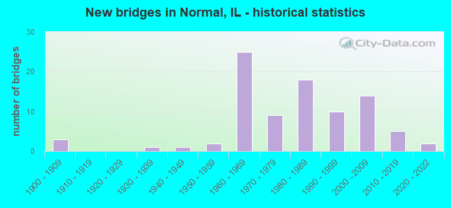
- New bridges - historical statistics
- 31900-1909
- 11930-1939
- 11940-1949
- 21950-1959
- 251960-1969
- 91970-1979
- 181980-1989
- 101990-1999
- 142000-2009
- 52010-2019
- 22020-2022

- Reconstructed bridges - Historical Statistics
- 11980-1989
- 81990-1999
- 22000-2009
- 22010-2019


- Bridge Condition - Deck
- 8.3%Very good
- 27.8%Good
- 52.8%Satisfactory
- 2.8%Fair
- 8.3%Poor

- Bridge Condition - Superstructure
- 13.9%Very good
- 30.6%Good
- 33.3%Satisfactory
- 19.4%Fair
- 2.8%Poor

- Bridge Condition - Substructure
- 19.4%Very good
- 55.6%Good
- 19.4%Satisfactory
- 2.8%Fair
- 2.8%Serious

- Bridge Condition - Channel
- 12.1%Excellent
- 21.2%Very good
- 18.2%Good
- 36.4%Satisfactory
- 12.1%Fair

- Bridge Condition - Culverts
- 8.0%Excellent
- 4.0%Very good
- 52.0%Good
- 32.0%Satisfactory
- 4.0%Poor
Find on map >> Show street view
Structure Number: 577807, Location: 1.4 MI NNW 150 & 51 (Lat: 40.507314, Lng: -89.001453), Route carried "on" structure: Other road , Year Built: 1955, Status: Open, Structure Length: 0.75m (2.46ft), Average Daily Traffic: 2,250 (year 2020), Truck Traffic: 6%, Average Future Daily Traffic: 4,859 (year 2032), Design Load: HS 20, Features Intersected: PHEASANT CREEK, Facility Carried by Structure: ADELAIDE ST-FAU 63
Minimum Vertical Clearance: 30+ m (98+ ft), Kilometerpoint: 1.078, Lanes on structure: 2, Owner: City or Municipal Highway Agency, Approaching Roadway Width: 8.8m (28.9ft), Skew: 2 degrees, Material/Design: Concrete continuous, Design/Construction: Culvert, Number Of Spans In Main Unit: 2, Length of Maximum Span: 3.8m (12.5ft), Curb or Sidewalk Widths: Left: 2.0m (6.6ft), Right: 2.0m (6.6ft), Curb-To-Curb Width: 8.8m (28.9ft), Out-to-Out Width: 13.4m (44.0ft)
Condition: Channel: Satisfactory, Culverts: Satisfactory, Operating Rating: 32.4 metric tons, Method Used To Determine Operating Rating: Field evaluation and documented engineering judgment, Inventory Rating: 17.5 metric tons, Method Used To Determine Inventory Rating: Field evaluation and documented engineering judgment, Structural Evaluation: Meets minimum limits, Deck Geometry: Meets minimum limits, Waterway Adequacy: Better than present minimum criteria, Approach Roadway Alignment: Equal to present desirable criteria, Designated Inspection Frequency: Every 24 months, Inspection Date: December 2021, Deck Structure Type: Concrete Cast-file-Place, Wearing Surface/Protective System: Wearing Surface: Bituminous
Find on map >> Show street view
Structure Number: 577809, Location: 1.2 MI NNW 51 & 150 (Lat: 40.502433, Lng: -89.004375), Route carried "on" structure: Other road , Year Built: 1964, Status: Open, Structure Length: 0.70m (2.30ft), Average Daily Traffic: 7,850 (year 2020), Truck Traffic: 5%, Average Future Daily Traffic: 12,399 (year 2032), Design Load: HS 20, Features Intersected: PHEASANT CREEK, Facility Carried by Structure: HOVEY AVE FAU 6353
Minimum Vertical Clearance: 30+ m (98+ ft), Kilometerpoint: 1.915, Lanes on structure: 4, Owner: City or Municipal Highway Agency, Approaching Roadway Width: 13.4m (44.0ft), Skew: 2 degrees, Material/Design: Concrete continuous, Design/Construction: Culvert, Number Of Spans In Main Unit: 2, Length of Maximum Span: 3.6m (11.8ft), Curb or Sidewalk Widths: Left: 1.2m (3.9ft), Right: 1.2m (3.9ft), Curb-To-Curb Width: 13.4m (44.0ft), Out-to-Out Width: 20.1m (65.9ft)
Condition: Channel: Satisfactory, Culverts: Satisfactory, Operating Rating: 53.8 metric tons, Method Used To Determine Operating Rating: Load Factor (LF) rating reported by rating factor (RF) method using MS18 loading, Inventory Rating: 32.4 metric tons, Method Used To Determine Inventory Rating: Load Factor (LF) rating reported by rating factor (RF) method using MS18 loading, Structural Evaluation: Equal to present minimum criteria, Deck Geometry: High priority of replacement, Waterway Adequacy: Equal to present desirable criteria, Approach Roadway Alignment: Equal to present desirable criteria, Designated Inspection Frequency: Every 24 months, Inspection Date: December 2021, Deck Structure Type: Concrete Cast-file-Place, Wearing Surface/Protective System: Wearing Surface: Bituminous
Find on map >> Show street view
Structure Number: 577815, Location: 0.7 MI N 51 & 150 (Lat: 40.498722, Lng: -88.991031), Route carried "on" structure: City street , Year Built: 1940, Status: Posted for load, Structure Length: 0.79m (2.59ft), Average Daily Traffic: 600 (year 2020), Truck Traffic: 6%, Average Future Daily Traffic: 1,731 (year 2032), Features Intersected: BR SUGAR CREEK, Facility Carried by Structure: FRANKLIN ST
Minimum Vertical Clearance: 30+ m (98+ ft), Kilometerpoint: 0.660, Lanes on structure: 2, Owner: City or Municipal Highway Agency, Approaching Roadway Width: 12.8m (42.0ft), Skew: 22 degrees, Material/Design: Concrete, Design/Construction: Slab, Number Of Spans In Main Unit: 1, Length of Maximum Span: 7.3m (24.0ft), Curb-To-Curb Width: 12.8m (42.0ft), Out-to-Out Width: 19.1m (62.7ft)
Condition: Deck: Poor, Superstructure: Poor, Substructure: Serious, Channel: Satisfactory, Operating Rating: 32.4 metric tons, Method Used To Determine Operating Rating: Field evaluation and documented engineering judgment, Inventory Rating: 19.4 metric tons, Method Used To Determine Inventory Rating: Field evaluation and documented engineering judgment, Structural Evaluation: High priority of corrective action, Deck Geometry: Superior to present desirable criteria, Waterway Adequacy: Equal to present desirable criteria, Approach Roadway Alignment: Better than present minimum criteria, Bridge Posting: Required (Relationship of Operating Rating to Maximum Legal Load: > 39.9% below), Length Of Structure Improvement: 1.43m (4.69ft), Designated Inspection Frequency: Every 24 months, Inspection Date: January 2022, Bridge Improvement Cost: $172,000, Roadway Improvement Cost: $17,000, Total Project Cost: $258,000, Deck Structure Type: Concrete Cast-file-Place, Wearing Surface/Protective System: Wearing Surface: Bituminous
Find on map >> Show street view
Structure Number: 577821, Location: 400 FT W OF LINDEN (Lat: 40.498272, Lng: -88.983608), Route carried "on" structure: Other road , Year Built: 1906, Year Reconstructed: 2001, Status: Open, Structure Length: 3.66m (12.01ft), Average Daily Traffic: 2,450 (year 2020), Truck Traffic: 2%, Average Future Daily Traffic: 3,798 (year 2032), Design Load: HS 15, Features Intersected: PED. & BIKE PATH, Facility Carried by Structure: VIRGINIA AVE-FAU63
Minimum Vertical Clearance: 30+ m (98+ ft), Kilometerpoint: 0.998, Lanes on structure: 2, Owner: City or Municipal Highway Agency, Approaching Roadway Width: 7.3m (24.0ft), Material/Design: Wood or Timber, Design/Construction: Stringer/Multi-beam, Number Of Spans In Main Unit: 7, Length of Maximum Span: 9.8m (32.2ft), Curb-To-Curb Width: 7.3m (24.0ft), Out-to-Out Width: 7.6m (24.9ft)
Condition: Deck: Satisfactory, Superstructure: Satisfactory, Substructure: Satisfactory, Operating Rating: 32.1 metric tons, Method Used To Determine Operating Rating: Allowable Stress (AS) rating reported by rating factor (RF) method using MS18 loading, Inventory Rating: 24.0 metric tons, Method Used To Determine Inventory Rating: Allowable Stress (AS) rating reported by rating factor (RF) method using MS18 loading, Structural Evaluation: Equal to present minimum criteria, Deck Geometry: High priority of replacement, Approach Roadway Alignment: Somewhat better than minimum adequacy, Length Of Structure Improvement: 4.63m (15.19ft), Designated Inspection Frequency: Every 24 months, Inspection Date: December 2020, Bridge Improvement Cost: $282,000, Roadway Improvement Cost: $28,000, Total Project Cost: $423,000, Deck Structure Type: Wood or Timber, Wearing Surface/Protective System: Wearing Surface: Wood or Timber
Find on map >> Show street view
Structure Number: 577822, Location: 0.75 MI NNE 51 & 150 (Lat: 40.499728, Lng: -88.990297), Route carried "on" structure: City street , Year Built: 2020, Status: Open, Structure Length: 1.06m (3.48ft), Average Daily Traffic: 225 (year 2020), Truck Traffic: 3%, Average Future Daily Traffic: 820 (year 2040), Design Load: HS 25 or greater, Features Intersected: BR SUGAR CREEK, Facility Carried by Structure: GLENN AVE.
Minimum Vertical Clearance: 30+ m (98+ ft), Kilometerpoint: 0.064, Lanes on structure: 2, Owner: City or Municipal Highway Agency, Approaching Roadway Width: 7.9m (25.9ft), Material/Design: Concrete continuous, Design/Construction: Culvert, Number Of Spans In Main Unit: 3, Length of Maximum Span: 3.7m (12.1ft), Curb or Sidewalk Widths: Left: 1.8m (5.9ft), Right: 1.8m (5.9ft), Curb-To-Curb Width: 7.9m (25.9ft), Out-to-Out Width: 13.2m (43.3ft)
Condition: Channel: Excellent, Culverts: Excellent, Operating Rating: 56.1 metric tons, Method Used To Determine Operating Rating: Load and Resistance Factor Rating (LRFR) rating reported by rating factor(RF) method using HL-93 loadings, Inventory Rating: 43.1 metric tons, Method Used To Determine Inventory Rating: Load and Resistance Factor Rating (LRFR) rating reported by rating factor(RF) method using HL-93 loadings, Structural Evaluation: Superior to present desirable criteria, Deck Geometry: Somewhat better than minimum adequacy, Waterway Adequacy: Equal to present desirable criteria, Approach Roadway Alignment: Equal to present desirable criteria, Designated Inspection Frequency: Every 24 months, Inspection Date: October 2020, Deck Structure Type: Concrete Cast-file-Place, Wearing Surface/Protective System: Deck Protection: Epoxy Coated Reinforcing
Find on map >> Show street view
Structure Number: 577823, Location: 1.3 MI NW 55 & 9 (Lat: 40.496186, Lng: -88.975819), Route carried "on" structure: City street , Year Built: 1950, Year Reconstructed: 2001, Status: Open, Structure Length: 1.33m (4.36ft), Average Daily Traffic: 225 (year 2020), Truck Traffic: 3%, Average Future Daily Traffic: 233 (year 2032), Design Load: HS 20, Features Intersected: SUGAR CREEK, Facility Carried by Structure: MS-6743 (BELT AVE)
Minimum Vertical Clearance: 30+ m (98+ ft), Kilometerpoint: 0.402, Lanes on structure: 2, Owner: City or Municipal Highway Agency, Approaching Roadway Width: 7.7m (25.3ft), Material/Design: Prestressed concrete, Design/Construction: Box Beam or Girders - Multiple, Number Of Spans In Main Unit: 2, Length of Maximum Span: 6.2m (20.3ft), Curb or Sidewalk Widths: Left: 0.0m, Right: 1.4m (4.6ft), Curb-To-Curb Width: 7.8m (25.6ft), Out-to-Out Width: 9.1m (29.9ft)
Condition: Deck: Good, Superstructure: Good, Substructure: Satisfactory, Channel: Very good, Operating Rating: 84.6 metric tons, Method Used To Determine Operating Rating: Load Factor (LF) rating reported by rating factor (RF) method using MS18 loading, Inventory Rating: 50.5 metric tons, Method Used To Determine Inventory Rating: Load Factor (LF) rating reported by rating factor (RF) method using MS18 loading, Structural Evaluation: Equal to present minimum criteria, Deck Geometry: Somewhat better than minimum adequacy, Waterway Adequacy: Equal to present desirable criteria, Approach Roadway Alignment: Better than present minimum criteria, Length Of Structure Improvement: 1.22m (4.00ft), Designated Inspection Frequency: Every 24 months, Inspection Date: July 2021, Bridge Improvement Cost: $58,000, Roadway Improvement Cost: $6,000, Total Project Cost: $87,000, Deck Structure Type: Concrete Precast Panels, Wearing Surface/Protective System: Wearing Surface: Bituminous
Find on map >> Show street view
Structure Number: 577825, Location: 1.0 MI NNW 55 & 9 (Lat: 40.503164, Lng: -88.957481), Route carried "on" structure: Other road , Year Built: 1970, Status: Open, Structure Length: 2.56m (8.40ft), Average Daily Traffic: 4,850 (year 2020), Truck Traffic: 3%, Average Future Daily Traffic: 7,931 (year 2032), Design Load: HS 20, Features Intersected: SUGAR CREEK, Facility Carried by Structure: TOWANDA AVE
Minimum Vertical Clearance: 30+ m (98+ ft), Kilometerpoint: 4.973, Lanes on structure: 2, Base Highway Network: Yes, Owner: City or Municipal Highway Agency, Approaching Roadway Width: 18.6m (61.0ft), Skew: 30 degrees, Material/Design: Concrete continuous, Design/Construction: Slab, Number Of Spans In Main Unit: 3, Length of Maximum Span: 9.4m (30.8ft), Curb or Sidewalk Widths: Left: 1.9m (6.2ft), Right: 1.9m (6.2ft), Curb-To-Curb Width: 19.4m (63.6ft), Out-to-Out Width: 24.1m (79.1ft)
Condition: Deck: Satisfactory, Superstructure: Satisfactory, Substructure: Good, Channel: Excellent, Operating Rating: 58.0 metric tons, Method Used To Determine Operating Rating: Load Factor (LF) rating reported by rating factor (RF) method using MS18 loading, Inventory Rating: 34.7 metric tons, Method Used To Determine Inventory Rating: Load Factor (LF) rating reported by rating factor (RF) method using MS18 loading, Structural Evaluation: Equal to present minimum criteria, Deck Geometry: Superior to present desirable criteria, Waterway Adequacy: Superior to present desirable criteria, Approach Roadway Alignment: Equal to present desirable criteria, Designated Inspection Frequency: Every 24 months, Inspection Date: November 2021, Deck Structure Type: Concrete Cast-file-Place, Wearing Surface/Protective System: Wearing Surface: Bituminous
Find on map >> Show street view
Structure Number: 577826, Location: 2.0 MI NNW 55 & 9 (Lat: 40.516825, Lng: -88.960778), Route carried "on" structure: Other road , Year Built: 1972, Status: Open, Structure Length: 0.75m (2.46ft), Average Daily Traffic: 7,450 (year 2020), Truck Traffic: 2%, Average Future Daily Traffic: 5,194 (year 2032), Design Load: HS 20, Features Intersected: DRAINAGE DITCH, Facility Carried by Structure: TOWANDA AVE-FAU 64
Minimum Vertical Clearance: 30+ m (98+ ft), Kilometerpoint: 3.380, Lanes on structure: 4, Base Highway Network: Yes, Owner: City or Municipal Highway Agency, Approaching Roadway Width: 13.4m (44.0ft), Material/Design: Concrete continuous, Design/Construction: Culvert, Number Of Spans In Main Unit: 2, Length of Maximum Span: 3.7m (12.1ft), Curb or Sidewalk Widths: Left: 1.2m (3.9ft), Right: 1.2m (3.9ft)
Condition: Channel: Fair, Culverts: Good, Operating Rating: 68.4 metric tons, Method Used To Determine Operating Rating: Load Factor (LF) rating reported by rating factor (RF) method using MS18 loading, Inventory Rating: 40.8 metric tons, Method Used To Determine Inventory Rating: Load Factor (LF) rating reported by rating factor (RF) method using MS18 loading, Structural Evaluation: Better than present minimum criteria, Waterway Adequacy: Equal to present desirable criteria, Approach Roadway Alignment: Equal to present desirable criteria, Designated Inspection Frequency: Every 24 months, Inspection Date: Febuary 2022, Wearing Surface/Protective System: Wearing Surface: Bituminous
Find on map >> Show street view
Structure Number: 577827, Location: 2.0 MI N. BUS55 & 9 (Lat: 40.517747, Lng: -88.953325), Route carried "on" structure: Other road , Year Built: 1985, Status: Open, Structure Length: 0.86m (2.82ft), Average Daily Traffic: 15,600 (year 2020), Truck Traffic: 5%, Average Future Daily Traffic: 13,069 (year 2032), Design Load: HS 20, Features Intersected: BR SUGAR CREEK, Facility Carried by Structure: FT JESSE RD-FAU 63
Minimum Vertical Clearance: 30+ m (98+ ft), Kilometerpoint: 3.621, Lanes on structure: 4, Base Highway Network: Yes, Owner: City or Municipal Highway Agency, Approaching Roadway Width: 16.2m (53.1ft), Skew: 5 degrees, Material/Design: Concrete continuous, Design/Construction: Culvert, Number Of Spans In Main Unit: 2, Length of Maximum Span: 4.5m (14.8ft)
Condition: Channel: Satisfactory, Culverts: Satisfactory, Operating Rating: 40.5 metric tons, Method Used To Determine Operating Rating: Load Factor (LF) rating reported by rating factor (RF) method using MS18 loading, Inventory Rating: 24.3 metric tons, Method Used To Determine Inventory Rating: Load Factor (LF) rating reported by rating factor (RF) method using MS18 loading, Structural Evaluation: Equal to present minimum criteria, Waterway Adequacy: Equal to present desirable criteria, Approach Roadway Alignment: Equal to present desirable criteria, Designated Inspection Frequency: Every 24 months, Inspection Date: December 2020, Wearing Surface/Protective System: Wearing Surface: Bituminous
Find on map >> Show street view
Structure Number: 577828, Location: 1.5 NNW 51 & 150 (Lat: 40.509850, Lng: -89.000481), Route carried "on" structure: Other road , Year Built: 1981, Status: Open, Structure Length: 1.14m (3.74ft), Average Daily Traffic: 12,900 (year 2021), Truck Traffic: 4%, Average Future Daily Traffic: 15,526 (year 2032), Design Load: HS 20, Features Intersected: PHEASANT CREEK, Facility Carried by Structure: COLLEGE AVE FAU 63
Minimum Vertical Clearance: 30+ m (98+ ft), Kilometerpoint: 5.359, Lanes on structure: 4, Base Highway Network: Yes, Owner: City or Municipal Highway Agency, Approaching Roadway Width: 14.0m (45.9ft), Material/Design: Concrete continuous, Design/Construction: Culvert, Number Of Spans In Main Unit: 3, Length of Maximum Span: 3.7m (12.1ft)
Condition: Channel: Good, Culverts: Satisfactory, Operating Rating: 73.9 metric tons, Method Used To Determine Operating Rating: Load Factor (LF) rating reported by rating factor (RF) method using MS18 loading, Inventory Rating: 44.1 metric tons, Method Used To Determine Inventory Rating: Load Factor (LF) rating reported by rating factor (RF) method using MS18 loading, Structural Evaluation: Equal to present minimum criteria, Waterway Adequacy: Equal to present desirable criteria, Approach Roadway Alignment: Equal to present desirable criteria, Designated Inspection Frequency: Every 24 months, Inspection Date: December 2021
Find on map >> Show street view
Structure Number: 577829, Location: 1.7 MI NNW BUS55 & 9 (Lat: 40.514922, Lng: -88.968694), Route carried "on" structure: Other road , Year Built: 1991, Status: Open, Structure Length: 1.16m (3.81ft), Average Daily Traffic: 1,400 (year 2020), Truck Traffic: 3%, Average Future Daily Traffic: 2,011 (year 2032), Design Load: HS 20, Features Intersected: SUGAR CREEK, Facility Carried by Structure: BLAIR DR
Minimum Vertical Clearance: 30+ m (98+ ft), Kilometerpoint: 0.177, Lanes on structure: 2, Owner: City or Municipal Highway Agency, Approaching Roadway Width: 13.4m (44.0ft), Skew: 1 degrees, Material/Design: Concrete continuous, Design/Construction: Culvert, Number Of Spans In Main Unit: 3, Length of Maximum Span: 3.9m (12.8ft), Curb or Sidewalk Widths: Left: 1.2m (3.9ft), Right: 1.2m (3.9ft), Curb-To-Curb Width: 13.4m (44.0ft), Out-to-Out Width: 24.7m (81.0ft)
Condition: Channel: Satisfactory, Culverts: Satisfactory, Operating Rating: 44.4 metric tons, Method Used To Determine Operating Rating: Assigned rating based on Load Factor Design (LFD) reported by rating factor (RF) using MS18 loading, Inventory Rating: 32.4 metric tons, Method Used To Determine Inventory Rating: Assigned rating based on Load Factor Design (LFD) reported by rating factor (RF) using MS18 loading, Structural Evaluation: Equal to present minimum criteria, Deck Geometry: Equal to present desirable criteria, Waterway Adequacy: Equal to present desirable criteria, Approach Roadway Alignment: Equal to present desirable criteria, Designated Inspection Frequency: Every 24 months, Inspection Date: January 2022, Deck Structure Type: Concrete Cast-file-Place, Wearing Surface/Protective System: Deck Protection: Epoxy Coated Reinforcing
Find on map >> Show street view
Structure Number: 57783, Location: 2.4 MI NNW BUS55 & 9 (Lat: 40.522761, Lng: -88.961744), Route carried "on" structure: Other road , Year Built: 1994, Status: Open, Structure Length: 4.77m (15.65ft), Average Daily Traffic: 6,850 (year 2020), Truck Traffic: 3%, Average Future Daily Traffic: 8,266 (year 2032), Design Load: HS 20, Features Intersected: SOUTHERN PACIFIC RR, Facility Carried by Structure: TOWANDA AVE
Minimum Vertical Clearance: 30+ m (98+ ft), Kilometerpoint: 2.639, Lanes on structure: 2, Base Highway Network: Yes, Owner: City or Municipal Highway Agency, Approaching Roadway Width: 16.2m (53.1ft), Material/Design: Steel continuous, Design/Construction: Stringer/Multi-beam, Number Of Spans In Main Unit: 3, Length of Maximum Span: 18.3m (60.0ft), Curb or Sidewalk Widths: Left: 0.0m, Right: 1.5m (4.9ft), Curb-To-Curb Width: 16.2m (53.1ft), Out-to-Out Width: 18.8m (61.7ft)
Condition: Deck: Good, Superstructure: Very good, Substructure: Very good, Operating Rating: 44.1 metric tons, Method Used To Determine Operating Rating: Assigned rating based on Load Factor Design (LFD) reported by rating factor (RF) using MS18 loading, Inventory Rating: 32.4 metric tons, Method Used To Determine Inventory Rating: Assigned rating based on Load Factor Design (LFD) reported by rating factor (RF) using MS18 loading, Structural Evaluation: Equal to present desirable criteria, Deck Geometry: Superior to present desirable criteria, Underclear: Equal to present desirable criteria, Approach Roadway Alignment: Equal to present desirable criteria, Designated Inspection Frequency: Every 48 months, Inspection Date: July 2019, Deck Structure Type: Concrete Cast-file-Place, Wearing Surface/Protective System: Deck Protection: Epoxy Coated Reinforcing
Find on map >> Show street view
Structure Number: 577831, Location: 1.3 MI NNE 51 & 150 (Lat: 40.503756, Lng: -88.982222), Route carried "on" structure: Other road , Year Built: 1994, Status: Open, Structure Length: 1.30m (4.27ft), Average Daily Traffic: 5,850 (year 2020), Truck Traffic: 3%, Average Future Daily Traffic: 10,612 (year 2032), Design Load: HS 20, Features Intersected: SUGARCREEK, Facility Carried by Structure: LINDEN ST
Minimum Vertical Clearance: 30+ m (98+ ft), Kilometerpoint: 7.000, Lanes on structure: 4, Base Highway Network: Yes, Owner: City or Municipal Highway Agency, Approaching Roadway Width: 14.3m (46.9ft), Skew: 3 degrees, Material/Design: Concrete continuous, Design/Construction: Culvert, Number Of Spans In Main Unit: 3, Length of Maximum Span: 3.4m (11.2ft), Curb or Sidewalk Widths: Left: 1.5m (4.9ft), Right: 1.5m (4.9ft), Curb-To-Curb Width: 14.3m (46.9ft), Out-to-Out Width: 18.0m (59.1ft)
Condition: Channel: Satisfactory, Culverts: Good, Operating Rating: 44.1 metric tons, Method Used To Determine Operating Rating: Load Factor (LF) rating reported by rating factor (RF) method using MS18 loading, Inventory Rating: 32.4 metric tons, Method Used To Determine Inventory Rating: Load Factor (LF) rating reported by rating factor (RF) method using MS18 loading, Structural Evaluation: Better than present minimum criteria, Deck Geometry: High priority of replacement, Waterway Adequacy: Equal to present desirable criteria, Approach Roadway Alignment: Equal to present desirable criteria, Designated Inspection Frequency: Every 48 months, Inspection Date: December 2021, Deck Structure Type: Concrete Cast-file-Place, Wearing Surface/Protective System: Wearing Surface: Low Slump Concrete, Deck Protection: Epoxy Coated Reinforcing
Find on map >> Show street view
Structure Number: 577833, Location: 0.7 MI NNE 51 & 150 (Lat: 40.496144, Lng: -88.990961), Route carried "on" structure: City street , Year Built: 2000, Status: Open, Structure Length: 1.58m (5.18ft), Average Daily Traffic: 675 (year 2020), Truck Traffic: 3%, Average Future Daily Traffic: 3,016 (year 2032), Design Load: HS 20, Features Intersected: SUGAR CREEK, Facility Carried by Structure: MS 6540(FRANKLIN S
Minimum Vertical Clearance: 30+ m (98+ ft), Kilometerpoint: 0.032, Lanes on structure: 2, Owner: City or Municipal Highway Agency, Approaching Roadway Width: 11.7m (38.4ft), Skew: 34 degrees, Material/Design: Concrete continuous, Design/Construction: Culvert, Number Of Spans In Main Unit: 3, Length of Maximum Span: 3.8m (12.5ft), Curb or Sidewalk Widths: Left: 3.1m (10.2ft), Right: 2.5m (8.2ft), Curb-To-Curb Width: 11.2m (36.7ft), Out-to-Out Width: 26.2m (86.0ft)
Condition: Channel: Good, Culverts: Good, Operating Rating: 44.1 metric tons, Method Used To Determine Operating Rating: Assigned rating based on Load Factor Design (LFD) reported by rating factor (RF) using MS18 loading, Inventory Rating: 32.4 metric tons, Method Used To Determine Inventory Rating: Assigned rating based on Load Factor Design (LFD) reported by rating factor (RF) using MS18 loading, Structural Evaluation: Better than present minimum criteria, Deck Geometry: Better than present minimum criteria, Waterway Adequacy: Superior to present desirable criteria, Approach Roadway Alignment: High priority of corrective action, Designated Inspection Frequency: Every 48 months, Inspection Date: Febuary 2020, Deck Structure Type: Concrete Cast-file-Place, Wearing Surface/Protective System: Deck Protection: Epoxy Coated Reinforcing
Find on map >> Show street view
Structure Number: 577834, Location: 0.7 MI N 51 & 150 (Lat: 40.504781, Lng: -88.989414), Route carried "on" structure: Other road , Year Built: 2010, Status: Open, Structure Length: 1.80m (5.91ft), Average Daily Traffic: 3,025 (year 2020), Truck Traffic: 3%, Average Future Daily Traffic: 5,753 (year 2032), Design Load: HS 20, Features Intersected: SUGAR CREEK, Facility Carried by Structure: VIRGINIA ST-FAU 63
Minimum Vertical Clearance: 30+ m (98+ ft), Kilometerpoint: 0.161, Lanes on structure: 2, Base Highway Network: Yes, Owner: City or Municipal Highway Agency, Approaching Roadway Width: 11.9m (39.0ft), Skew: 4 degrees, Material/Design: Concrete continuous, Design/Construction: Culvert, Number Of Spans In Main Unit: 3, Length of Maximum Span: 6.1m (20.0ft), Curb or Sidewalk Widths: Left: 1.5m (4.9ft), Right: 1.5m (4.9ft), Curb-To-Curb Width: 11.9m (39.0ft), Out-to-Out Width: 16.5m (54.1ft)
Condition: Channel: Good, Culverts: Good, Operating Rating: 70.0 metric tons, Method Used To Determine Operating Rating: Load Factor (LF) rating reported by rating factor (RF) method using MS18 loading, Inventory Rating: 41.8 metric tons, Method Used To Determine Inventory Rating: Load Factor (LF) rating reported by rating factor (RF) method using MS18 loading, Structural Evaluation: Better than present minimum criteria, Deck Geometry: Somewhat better than minimum adequacy, Waterway Adequacy: Equal to present desirable criteria, Approach Roadway Alignment: Equal to present desirable criteria, Designated Inspection Frequency: Every 48 months, Inspection Date: March 2021, Deck Structure Type: Concrete Cast-file-Place, Wearing Surface/Protective System: Deck Protection: Epoxy Coated Reinforcing
Find on map >> Show street view
Structure Number: 577835, Location: 0.7 MI N 51 & 150 (Lat: 40.498761, Lng: -88.992692), Route carried "on" structure: City street , Year Built: 2004, Status: Open, Structure Length: 1.25m (4.10ft), Average Daily Traffic: 725 (year 2020), Truck Traffic: 3%, Average Future Daily Traffic: 1,229 (year 2032), Design Load: HS 20, Features Intersected: N BR. SUGAR CREEK, Facility Carried by Structure: UNIVERSITY STREET
Minimum Vertical Clearance: 30+ m (98+ ft), Kilometerpoint: 1.641, Lanes on structure: 2, Owner: City or Municipal Highway Agency, Approaching Roadway Width: 11.9m (39.0ft), Material/Design: Concrete, Design/Construction: Culvert, Number Of Spans In Main Unit: 3, Length of Maximum Span: 4.0m (13.1ft), Curb or Sidewalk Widths: Left: 2.2m (7.2ft), Right: 2.3m (7.5ft), Curb-To-Curb Width: 11.9m (39.0ft), Out-to-Out Width: 17.3m (56.8ft)
Condition: Channel: Very good, Culverts: Good, Operating Rating: 53.8 metric tons, Method Used To Determine Operating Rating: Field evaluation and documented engineering judgment, Inventory Rating: 32.4 metric tons, Method Used To Determine Inventory Rating: Field evaluation and documented engineering judgment, Structural Evaluation: Better than present minimum criteria, Deck Geometry: Better than present minimum criteria, Waterway Adequacy: Better than present minimum criteria, Approach Roadway Alignment: Superior to present desirable criteria, Designated Inspection Frequency: Every 48 months, Inspection Date: August 2021
Find on map >> Show street view
Structure Number: 577836, Location: 1.8 MI NE 9/BUS51 (Lat: 40.510378, Lng: -88.974522), Route carried "on" structure: Other road , Year Built: 2008, Status: Open, Structure Length: 2.13m (6.99ft), Average Daily Traffic: 12,200 (year 2020), Truck Traffic: 2%, Average Future Daily Traffic: 17,649 (year 2032), Design Load: HS 25 or greater, Features Intersected: N FORK SUGAR CR, Facility Carried by Structure: COLLEGE AVE
Minimum Vertical Clearance: 30+ m (98+ ft), Kilometerpoint: 7.612, Lanes on structure: 4, Base Highway Network: Yes, Owner: City or Municipal Highway Agency, Approaching Roadway Width: 13.4m (44.0ft), Skew: 2 degrees, Material/Design: Prestressed concrete, Design/Construction: Stringer/Multi-beam, Number Of Spans In Main Unit: 1, Length of Maximum Span: 21.0m (68.9ft), Curb or Sidewalk Widths: Left: 1.5m (4.9ft), Right: 1.5m (4.9ft), Curb-To-Curb Width: 14.4m (47.2ft), Out-to-Out Width: 19.2m (63.0ft)
Condition: Deck: Satisfactory, Superstructure: Very good, Substructure: Very good, Channel: Satisfactory, Operating Rating: 44.1 metric tons, Method Used To Determine Operating Rating: Assigned rating based on Load Factor Design (LFD) reported by rating factor (RF) using MS18 loading, Inventory Rating: 32.4 metric tons, Method Used To Determine Inventory Rating: Assigned rating based on Load Factor Design (LFD) reported by rating factor (RF) using MS18 loading, Structural Evaluation: Equal to present desirable criteria, Deck Geometry: High priority of replacement, Waterway Adequacy: Superior to present desirable criteria, Approach Roadway Alignment: Equal to present desirable criteria, Designated Inspection Frequency: Every 48 months, Inspection Date: July 2019, Deck Structure Type: Concrete Precast Panels, Wearing Surface/Protective System: Wearing Surface: Integral Concrete, Deck Protection: Epoxy Coated Reinforcing
Find on map >> Show street view
Structure Number: 577837, Location: SHEPARD RD W VETERNS (Lat: 40.524625, Lng: -88.952708), Route carried "on" structure: City street , Year Built: 2007, Status: Open, Structure Length: 2.32m (7.61ft), Average Daily Traffic: 1,700 (year 2020), Truck Traffic: 1%, Average Future Daily Traffic: 1,229 (year 2032), Design Load: HS 20, Features Intersected: N BR SUGAR CR, Facility Carried by Structure: SHEPARD ROAD
Minimum Vertical Clearance: 30+ m (98+ ft), Kilometerpoint: 0.257, Lanes on structure: 4, Owner: City or Municipal Highway Agency, Approaching Roadway Width: 17.7m (58.1ft), Skew: 30 degrees, Material/Design: Concrete continuous, Design/Construction: Culvert, Number Of Spans In Main Unit: 9, Length of Maximum Span: 2.6m (8.5ft), Curb-To-Curb Width: 17.7m (58.1ft)
Condition: Channel: Fair, Culverts: Good, Operating Rating: 38.9 metric tons, Method Used To Determine Operating Rating: Load Factor (LF) rating reported by rating factor (RF) method using MS18 loading, Inventory Rating: 23.3 metric tons, Method Used To Determine Inventory Rating: Load Factor (LF) rating reported by rating factor (RF) method using MS18 loading, Structural Evaluation: Equal to present minimum criteria, Deck Geometry: Somewhat better than minimum adequacy, Waterway Adequacy: Superior to present desirable criteria, Approach Roadway Alignment: Superior to present desirable criteria, Designated Inspection Frequency: Every 24 months, Inspection Date: April 2020, Wearing Surface/Protective System: Wearing Surface: Bituminous
Find on map >> Show street view
Structure Number: 577839, Location: 0.14 MI E US 51 (Lat: 40.496458, Lng: -88.991689), Route carried "on" structure: City street , Year Built: 2009, Status: Open, Structure Length: 1.85m (6.07ft), Average Daily Traffic: 900 (year 2020), Truck Traffic: 6%, Average Future Daily Traffic: 1,300 (year 2035), Design Load: HS 20, Features Intersected: SUGAR CREEK, Facility Carried by Structure: APPLE ST
Minimum Vertical Clearance: 30+ m (98+ ft), Kilometerpoint: 0.483, Lanes on structure: 2, Owner: City or Municipal Highway Agency, Approaching Roadway Width: 10.1m (33.1ft), Skew: 5 degrees, Material/Design: Concrete, Design/Construction: Culvert, Number Of Spans In Main Unit: 3, Length of Maximum Span: 6.4m (21.0ft), Curb or Sidewalk Widths: Left: 1.5m (4.9ft), Right: 1.5m (4.9ft), Curb-To-Curb Width: 10.1m (33.1ft), Out-to-Out Width: 14.7m (48.2ft)
Condition: Channel: Excellent, Culverts: Good, Operating Rating: 42.1 metric tons, Method Used To Determine Operating Rating: Assigned ratings based on Load and Resistance Factor Design (LRFD) reported by rating factor (RF) using HL93 loadings, Inventory Rating: 32.4 metric tons, Method Used To Determine Inventory Rating: Assigned ratings based on Load and Resistance Factor Design (LRFD) reported by rating factor (RF) using HL93 loadings, Structural Evaluation: Better than present minimum criteria, Deck Geometry: Equal to present minimum criteria, Waterway Adequacy: Superior to present desirable criteria, Approach Roadway Alignment: Equal to present desirable criteria, Designated Inspection Frequency: Every 48 months, Inspection Date: November 2021, Deck Structure Type: Concrete Cast-file-Place, Wearing Surface/Protective System: Deck Protection: Epoxy Coated Reinforcing
Find on map >> Show street view
Structure Number: 57784, Location: 0.7 mi N of 50 & 150 (Lat: 40.497389, Lng: -88.992633), Route carried "on" structure: City street , Year Built: 2015, Status: Open, Structure Length: 2.07m (6.79ft), Average Daily Traffic: 575 (year 2020), Truck Traffic: 15%, Average Future Daily Traffic: 2,513 (year 2032), Design Load: HS 25 or greater, Features Intersected: Sugar Creek, Facility Carried by Structure: MS-6505 University
Minimum Vertical Clearance: 30+ m (98+ ft), Kilometerpoint: 1.802, Lanes on structure: 2, Owner: City or Municipal Highway Agency, Approaching Roadway Width: 9.1m (29.9ft), Skew: 4 degrees, Material/Design: Concrete continuous, Design/Construction: Culvert, Number Of Spans In Main Unit: 4, Length of Maximum Span: 5.2m (17.1ft), Curb or Sidewalk Widths: Left: 1.5m (4.9ft), Right: 1.5m (4.9ft), Curb-To-Curb Width: 12.2m (40.0ft), Out-to-Out Width: 14.1m (46.3ft)
Condition: Channel: Very good, Culverts: Good, Operating Rating: 42.1 metric tons, Method Used To Determine Operating Rating: Assigned ratings based on Load and Resistance Factor Design (LRFD) reported by rating factor (RF) using HL93 loadings, Inventory Rating: 32.4 metric tons, Method Used To Determine Inventory Rating: Assigned ratings based on Load and Resistance Factor Design (LRFD) reported by rating factor (RF) using HL93 loadings, Structural Evaluation: Better than present minimum criteria, Deck Geometry: Equal to present desirable criteria, Waterway Adequacy: Equal to present desirable criteria, Approach Roadway Alignment: Equal to present desirable criteria, Designated Inspection Frequency: Every 48 months, Inspection Date: July 2019, Deck Structure Type: Concrete Cast-file-Place, Wearing Surface/Protective System: Deck Protection: Epoxy Coated Reinforcing
Find on map >> Show street view
Structure Number: 577841, Location: 240' S of Florance A (Lat: 40.502756, Lng: -88.985603), Route carried "on" structure: City street , Year Built: 2012, Status: Open, Structure Length: 1.38m (4.53ft), Average Daily Traffic: 425 (year 2020), Truck Traffic: 2%, Average Future Daily Traffic: 1,387 (year 2032), Design Load: HS 20, Features Intersected: Sugar Creek, Facility Carried by Structure: Broadway Ave.
Minimum Vertical Clearance: 30+ m (98+ ft), Kilometerpoint: 0.837, Lanes on structure: 2, Owner: City or Municipal Highway Agency, Approaching Roadway Width: 12.2m (40.0ft), Skew: 30 degrees, Material/Design: Concrete, Design/Construction: Culvert, Number Of Spans In Main Unit: 3, Number Of Approach Spans: 3, Length of Maximum Span: 4.4m (14.4ft), Curb or Sidewalk Widths: Left: 1.5m (4.9ft), Right: 1.5m (4.9ft), Curb-To-Curb Width: 12.2m (40.0ft), Out-to-Out Width: 30.5m (100.1ft)
Condition: Channel: Very good, Culverts: Good, Operating Rating: 42.1 metric tons, Method Used To Determine Operating Rating: Assigned ratings based on Load and Resistance Factor Design (LRFD) reported by rating factor (RF) using HL93 loadings, Inventory Rating: 32.4 metric tons, Method Used To Determine Inventory Rating: Assigned ratings based on Load and Resistance Factor Design (LRFD) reported by rating factor (RF) using HL93 loadings, Structural Evaluation: Better than present minimum criteria, Deck Geometry: Better than present minimum criteria, Waterway Adequacy: Superior to present desirable criteria, Approach Roadway Alignment: Equal to present desirable criteria, Designated Inspection Frequency: Every 48 months, Inspection Date: December 2018, Deck Structure Type: Concrete Cast-file-Place, Wearing Surface/Protective System: Deck Protection: Epoxy Coated Reinforcing
Find on map >> Show street view
Structure Number: 570018, Location: 3.8 MI SW OF RT 51 (Lat: 40.503694, Lng: -89.028381), Route carried "under" structure: Other road , Year Built: 1963, Structure Length: 0. m, Average Daily Traffic: 4,250 (year 2020), Truck Traffic: 11%, Features Intersected: OLD 150 & N&W RR, Facility Carried by Structure: I-55/I-74 NB
Minimum Vertical Clearance: 7.90m (25.92ft), Kilometerpoint: 4.281, Lanes on structure: 3, Lanes under structure: 2, Material/Design: Steel continuous, Design/Construction: Stringer/Multi-beam, Length of Maximum Span: 30.5m (100.1ft)
Find on map >> Show street view
Structure Number: 570019, Location: 3.8 M SW OF RT 51 (Lat: 40.503911, Lng: -89.028581), Route carried "under" structure: Other road , Year Built: 1963, Structure Length: 0. m, Average Daily Traffic: 4,250 (year 2020), Truck Traffic: 11%, Features Intersected: OLD 150 & N&W RR, Facility Carried by Structure: I-55/I-74 SB
Minimum Vertical Clearance: 7.98m (26.18ft), Kilometerpoint: 4.249, Lanes on structure: 3, Lanes under structure: 2, Material/Design: Steel continuous, Design/Construction: Stringer/Multi-beam, Length of Maximum Span: 30.5m (100.1ft)
Find on map >> Show street view
Structure Number: 570022, Location: I-55NB OVER I-74 (Lat: 40.535594, Lng: -89.028686), Route carried "under" structure: Interstate 74, Year Built: 1962, Structure Length: 0. m, Average Daily Traffic: 26,000 (year 2021), Truck Traffic: 20%, Features Intersected: I-74, Facility Carried by Structure: I-55 NW BLOOMINGTO
Minimum Vertical Clearance: 5.21m (17.09ft), Kilometerpoint: 207.600, Lanes on structure: 4, Lanes under structure: 2, Material/Design: Steel continuous, Design/Construction: Stringer/Multi-beam, Length of Maximum Span: 15.9m (52.2ft)
Find on map >> Show street view
Structure Number: 570023, Location: I-55SB OVER I-74 (Lat: 40.535594, Lng: -89.028686), Route carried "under" structure: Interstate 74, Year Built: 1962, Structure Length: 0. m, Average Daily Traffic: 26,000 (year 2021), Truck Traffic: 20%, Features Intersected: I-74, Facility Carried by Structure: I-55 NW BLOOMINGTO
Minimum Vertical Clearance: 5.05m (16.57ft), Kilometerpoint: 207.600, Lanes on structure: 3, Lanes under structure: 2, Material/Design: Steel continuous, Design/Construction: Stringer/Multi-beam, Length of Maximum Span: 15.9m (52.2ft)
Find on map >> Show street view
Structure Number: 570024, Location: INTER I 55 & US 51B (Lat: 40.538358, Lng: -88.996156), Route carried "under" structure: Business US 51, Year Built: 1962, Structure Length: 0. m, Average Daily Traffic: 13,700 (year 2021), Truck Traffic: 9%, Features Intersected: US 51B (Main St), Facility Carried by Structure: I-55 NB
Minimum Vertical Clearance: 5.08m (16.67ft), Kilometerpoint: 17.059, Lanes on structure: 3, Lanes under structure: 5, Material/Design: Steel continuous, Design/Construction: Stringer/Multi-beam, Length of Maximum Span: 17.4m (57.1ft)
Find on map >> Show street view
Structure Number: 570025, Location: INTER I-55 & US 51B (Lat: 40.538994, Lng: -88.996186), Route carried "under" structure: Business US 51, Year Built: 1962, Structure Length: 0. m, Average Daily Traffic: 7,250 (year 2021), Truck Traffic: 17%, Features Intersected: US 51B (Main St), Facility Carried by Structure: I-55 SB & CD#2279
Minimum Vertical Clearance: 4.45m (14.60ft), Kilometerpoint: 17.091, Lanes on structure: 5, Lanes under structure: 4, Material/Design: Steel continuous, Design/Construction: Stringer/Multi-beam, Length of Maximum Span: 17.4m (57.1ft)
Find on map >> Show street view
Structure Number: 570069, Location: 2.8 MI N OF ILL 9 (Lat: 40.529814, Lng: -88.951619), Route carried "under" structure: Other road , Year Built: 1939, Structure Length: 0. m, Average Daily Traffic: 2,800 (year 2020), Truck Traffic: 10%, Features Intersected: OLD RT 66/ICG RR, Facility Carried by Structure: I-55 BUSN LOOP
Minimum Vertical Clearance: 6.55m (21.49ft), Kilometerpoint: 3.927, Lanes on structure: 6, Lanes under structure: 2, Material/Design: Steel continuous, Design/Construction: Stringer/Multi-beam, Length of Maximum Span: 26.3m (86.3ft)
Find on map >> Show street view
Structure Number: 570073, Location: OVER I-74 NW NORMAL (Lat: 40.539839, Lng: -89.063500), Route carried "under" structure: Interstate 74, Year Built: 1964, Structure Length: 0. m, Average Daily Traffic: 26,000 (year 2021), Truck Traffic: 20%, Features Intersected: FAI 74, Facility Carried by Structure: US 150
Minimum Vertical Clearance: 4.98m (16.34ft), Kilometerpoint: 204.268, Lanes on structure: 4, Lanes under structure: 4, Material/Design: Steel continuous, Design/Construction: Stringer/Multi-beam, Length of Maximum Span: 25.6m (84.0ft)
Find on map >> Show street view
Structure Number: 570105, Location: 1 MILE W OF I-55 (Lat: 40.539089, Lng: -89.041911), Route carried "under" structure: Interstate 74, Year Built: 1963, Structure Length: 0. m, Average Daily Traffic: 26,000 (year 2021), Truck Traffic: 20%, Features Intersected: I-74, Facility Carried by Structure: FAS 1473
Minimum Vertical Clearance: 5.05m (16.57ft), Kilometerpoint: 206.103, Lanes on structure: 2, Lanes under structure: 4, Material/Design: Steel continuous, Design/Construction: Stringer/Multi-beam, Length of Maximum Span: 20.7m (67.9ft)
Find on map >> Show street view
Structure Number: 570115, Location: 4 MILES W OF I-55 (Lat: 40.545761, Lng: -89.086600), Route carried "under" structure: Interstate 74, Year Built: 1964, Structure Length: 0. m, Average Daily Traffic: 27,300 (year 2021), Truck Traffic: 18%, Features Intersected: I-74, Facility Carried by Structure: TR 201
Minimum Vertical Clearance: 4.90m (16.08ft), Kilometerpoint: 202.112, Lanes on structure: 2, Lanes under structure: 4, Material/Design: Steel continuous, Design/Construction: Stringer/Multi-beam, Length of Maximum Span: 25.7m (84.3ft)
Find on map >> Show street view
Structure Number: 570118, Location: 1.75 MI E OF US 51 (Lat: 40.538817, Lng: -88.963361), Route carried "under" structure: Interstate 55, Year Built: 1962, Structure Length: 0. m, Average Daily Traffic: 30,200 (year 2021), Truck Traffic: 25%, Features Intersected: I-55/N OF NORMAL, Facility Carried by Structure: TOWANDA AVE(FAU641
Minimum Vertical Clearance: 5.00m (16.40ft), Kilometerpoint: 267.884, Lanes on structure: 2, Lanes under structure: 6, Material/Design: Steel continuous, Design/Construction: Stringer/Multi-beam, Length of Maximum Span: 20.6m (67.6ft)
Find on map >> Show street view
Structure Number: 570186, Location: KINGSLEY ST & ICG (Lat: 40.501319, Lng: -88.995039), Route carried "under" structure: Business US 51, Year Built: 1978, Structure Length: 0. m, Average Daily Traffic: 9,800 (year 2021), Truck Traffic: 5%, Features Intersected: US 51 SB, Facility Carried by Structure: I.C.G. RR
Minimum Vertical Clearance: 4.55m (14.93ft), Kilometerpoint: 30.866, Lanes under structure: 2, Material/Design: Steel, Design/Construction: Stringer/Multi-beam, Length of Maximum Span: 22.6m (74.1ft)
Find on map >> Show street view
Structure Number: 570189, Location: MAIN ST UNDER ICG RR (Lat: 40.501797, Lng: -88.994561), Route carried "under" structure: Business US 51, Year Built: 1979, Structure Length: 0. m, Average Daily Traffic: 11,300 (year 2021), Truck Traffic: 6%, Features Intersected: US 51 NB, Facility Carried by Structure: I.C.G. RR
Minimum Vertical Clearance: 4.29m (14.07ft), Kilometerpoint: 12.955, Lanes under structure: 2, Material/Design: Steel, Design/Construction: Stringer/Multi-beam, Length of Maximum Span: 23.3m (76.4ft)
Find on map >> Show street view
Structure Number: 570202, Location: 2.9 MI N OF ILL 9 (Lat: 40.529272, Lng: -89.058483), Route carried "under" structure: Other road , Year Built: 1987, Structure Length: 0. m, Average Daily Traffic: 2,750 (year 2020), Truck Traffic: 9%, Features Intersected: N&W RR/WHITE OAK RD, Facility Carried by Structure: US 150/FAP 676& SP
Minimum Vertical Clearance: 5.51m (18.08ft), Kilometerpoint: 0.338, Lanes on structure: 4, Lanes under structure: 2, Material/Design: Steel continuous, Design/Construction: Stringer/Multi-beam, Length of Maximum Span: 43.7m (143.4ft)
Find on map >> Show street view
Structure Number: 570213, Location: 0.22 MI W OF OLD 51 (Lat: 40.561247, Lng: -89.002358), Route carried "under" structure: Interstate 39, Year Built: 1988, Structure Length: 0. m, Average Daily Traffic: 18,500 (year 2021), Truck Traffic: 35%, Features Intersected: I-39/US 51, Facility Carried by Structure: TR#181 (BUSN. 51)
Minimum Vertical Clearance: 5.08m (16.67ft), Kilometerpoint: 3.766, Lanes on structure: 4, Lanes under structure: 4, Material/Design: Steel continuous, Design/Construction: Stringer/Multi-beam, Length of Maximum Span: 50.3m (165.0ft)
Find on map >> Show street view
Structure Number: 570214, Location: 0.35 MI W OF BUS.51 (Lat: 40.538933, Lng: -89.003450), Route carried "under" structure: Interstate 55, Year Built: 1988, Structure Length: 0. m, Average Daily Traffic: 29,000 (year 2021), Truck Traffic: 26%, Features Intersected: I-55, Facility Carried by Structure: I-39 RAMP 816 SB
Minimum Vertical Clearance: 5.28m (17.32ft), Kilometerpoint: 264.569, Lanes on structure: 1, Lanes under structure: 4, Material/Design: Steel continuous, Design/Construction: Stringer/Multi-beam, Length of Maximum Span: 34.6m (113.5ft)
Find on map >> Show street view
Structure Number: 570215, Location: 0.29 MI W OF OLD 51 (Lat: 40.538928, Lng: -89.003122), Route carried "under" structure: Interstate 55, Year Built: 1989, Structure Length: 0. m, Average Daily Traffic: 29,000 (year 2021), Truck Traffic: 26%, Features Intersected: I-55 & CD#2284/2287, Facility Carried by Structure: I-39 NB
Minimum Vertical Clearance: 5.23m (17.16ft), Kilometerpoint: 264.601, Lanes on structure: 2, Lanes under structure: 4, Material/Design: Steel continuous, Design/Construction: Stringer/Multi-beam, Length of Maximum Span: 35.2m (115.5ft)
Find on map >> Show street view
Structure Number: 570216, Location: O.53 MI N OF I-55 (Lat: 40.546592, Lng: -89.002836), Route carried "under" structure: County highway , Year Built: 1988, Structure Length: 0. m, Average Daily Traffic: 850 (year 2020), Truck Traffic: 22%, Features Intersected: NORTHTOWN RD TR 201B, Facility Carried by Structure: I-39 SB
Minimum Vertical Clearance: 4.39m (14.40ft), Kilometerpoint: 3.283, Lanes on structure: 3, Lanes under structure: 2, Material/Design: Steel, Design/Construction: Stringer/Multi-beam, Length of Maximum Span: 32.1m (105.3ft)
Find on map >> Show street view
Structure Number: 570217, Location: 0.32 MI W OF OLD 51 (Lat: 40.546592, Lng: -89.002378), Route carried "under" structure: County highway , Year Built: 1988, Structure Length: 0. m, Average Daily Traffic: 850 (year 2020), Truck Traffic: 22%, Features Intersected: NORTHTOWN RD TR 201B, Facility Carried by Structure: I-39 NB
Minimum Vertical Clearance: 4.39m (14.40ft), Kilometerpoint: 3.331, Lanes on structure: 2, Lanes under structure: 2, Material/Design: Steel, Design/Construction: Stringer/Multi-beam, Length of Maximum Span: 32.0m (105.0ft)
Find on map >> Show street view
Structure Number: 570223, Location: 3 MI N OF ILL 9 (Lat: 40.531019, Lng: -89.027211), Route carried "under" structure: Interstate 55, Year Built: 1990, Structure Length: 0. m, Average Daily Traffic: 37,300 (year 2021), Truck Traffic: 34%, Features Intersected: I-55 & I-74, Facility Carried by Structure: Raab Rd (FAU 6346)
Minimum Vertical Clearance: 5.23m (17.16ft), Kilometerpoint: 262.026, Lanes on structure: 2, Lanes under structure: 8, Material/Design: Steel continuous, Design/Construction: Stringer/Multi-beam, Length of Maximum Span: 53.8m (176.5ft)
Find on map >> Show street view
Structure Number: 570233, Location: 3.5 MI SW OF RT 51 (Lat: 40.509636, Lng: -89.028289), Route carried "under" structure: Other road , Year Built: 1999, Structure Length: 0. m, Average Daily Traffic: 6,050 (year 2020), Truck Traffic: 7%, Features Intersected: College Ave(FAU6352), Facility Carried by Structure: I-55/I-74 NB
Minimum Vertical Clearance: 4.50m (14.76ft), Kilometerpoint: 2.977, Lanes on structure: 3, Lanes under structure: 2, Material/Design: Steel continuous, Design/Construction: Stringer/Multi-beam, Length of Maximum Span: 18.3m (60.0ft)
Find on map >> Show street view
Structure Number: 570234, Location: 3.5 M SW OF RT 51 (Lat: 40.509631, Lng: -89.028639), Route carried "under" structure: Other road , Year Built: 1999, Structure Length: 0. m, Average Daily Traffic: 6,050 (year 2020), Truck Traffic: 7%, Features Intersected: College Ave(FAU6352), Facility Carried by Structure: I-55/I-74 SB
Minimum Vertical Clearance: 4.65m (15.26ft), Kilometerpoint: 2.945, Lanes on structure: 3, Lanes under structure: 2, Material/Design: Steel continuous, Design/Construction: Stringer/Multi-beam, Length of Maximum Span: 18.3m (60.0ft)
Find on map >> Show street view
Structure Number: 570235, Location: 0.7 MI E OF US 51 (Lat: 40.538217, Lng: -88.983483), Route carried "under" structure: Other road , Year Built: 2009, Structure Length: 0. m, Average Daily Traffic: 4,400 (year 2020), Truck Traffic: 5%, Features Intersected: FAU 6405/LINDEN, Facility Carried by Structure: I-55 NB
Minimum Vertical Clearance: 4.52m (14.83ft), Kilometerpoint: 3.170, Lanes on structure: 3, Lanes under structure: 2, Material/Design: Steel continuous, Design/Construction: Stringer/Multi-beam, Length of Maximum Span: 18.3m (60.0ft)
Find on map >> Show street view
Structure Number: 570236, Location: 0.7 MI E OF US 51 (Lat: 40.538500, Lng: -88.983489), Route carried "under" structure: Other road , Year Built: 2009, Structure Length: 0. m, Average Daily Traffic: 4,400 (year 2020), Truck Traffic: 5%, Features Intersected: FAU 6405/LINDEN, Facility Carried by Structure: I-55 SB
Minimum Vertical Clearance: 4.52m (14.83ft), Kilometerpoint: 3.138, Lanes on structure: 3, Lanes under structure: 2, Material/Design: Steel continuous, Design/Construction: Stringer/Multi-beam, Length of Maximum Span: 18.3m (60.0ft)
Find on map >> Show street view
Structure Number: 570237, Location: JCT. FAI55 & VET PKW (Lat: 40.537522, Lng: -88.948747), Route carried "under" structure: Business Interstate 55, Year Built: 2004, Structure Length: 0. m, Average Daily Traffic: 19,100 (year 2021), Truck Traffic: 7%, Features Intersected: FAP 704
Minimum Vertical Clearance: 5.82m (19.09ft), Kilometerpoint: 51.433, Lanes on structure: 3, Lanes under structure: 4, Material/Design: Steel continuous, Design/Construction: Stringer/Multi-beam, Length of Maximum Span: 32.8m (107.6ft)
Find on map >> Show street view
Structure Number: 570238, Location: NE CORNER NORMAL (Lat: 40.537592, Lng: -88.948664), Route carried "under" structure: Business Interstate 55, Year Built: 2004, Structure Length: 0. m, Average Daily Traffic: 19,100 (year 2021), Truck Traffic: 7%, Features Intersected: FAP 704
Minimum Vertical Clearance: 5.26m (17.26ft), Kilometerpoint: 51.433, Lanes on structure: 3, Lanes under structure: 4, Material/Design: Steel continuous, Design/Construction: Stringer/Multi-beam, Length of Maximum Span: 33.1m (108.6ft)
Find on map >> Show street view
Structure Number: 576308, Location: 150 FT W OF LEE ST (Lat: 40.495156, Lng: -88.998636), Route carried "under" structure: City street , Year Built: 1900, Structure Length: 0. m, Average Daily Traffic: 1,025 (year 2020), Truck Traffic: 16%, Features Intersected: DIVISION ST, Facility Carried by Structure: SOUTHERN PACIFIC R
Minimum Vertical Clearance: 3.63m (11.91ft), Kilometerpoint: 0.274, Lanes under structure: 2, Material/Design: Concrete, Design/Construction: Slab, Length of Maximum Span: 6.4m (21.0ft)
Find on map >> Show street view
Structure Number: 577817, Location: VERNON E OF BEUFORT (Lat: 40.504900, Lng: -88.990889), Route carried "under" structure: Other road , Year Built: 1972, Structure Length: 0. m, Average Daily Traffic: 6,050 (year 2020), Truck Traffic: 3%, Features Intersected: VERNON AVE, Facility Carried by Structure: SPCSL RR
Minimum Vertical Clearance: 4.34m (14.24ft), Kilometerpoint: 0.048, Lanes under structure: 4, Material/Design: Steel, Design/Construction: Stringer/Multi-beam, Length of Maximum Span: 15.5m (50.9ft)
Find on map >> Show street view
Structure Number: 577818, Location: S OF BEAUFORT (Lat: 40.505433, Lng: -88.990125), Route carried "under" structure: City street , Year Built: 1900, Structure Length: 0. m, Average Daily Traffic: 175 (year 2020), Truck Traffic: 3%, Features Intersected: STREET, Facility Carried by Structure: SPCSL RR
Minimum Vertical Clearance: 4.01m (13.16ft), Kilometerpoint: 0.032, Lanes under structure: 2, Material/Design: Steel, Design/Construction: Girder and Floorbeam System, Length of Maximum Span: 10.4m (34.1ft)