Bridge Statistics for North East, Pennsylvania (PA)
Condition, Traffic, Stress, Structural Evaluation, Project Costs
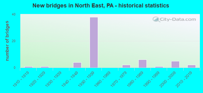
- New bridges - historical statistics
- 11910-1919
- 11920-1929
- 41940-1949
- 381950-1959
- 21970-1979
- 61980-1989
- 11990-1999
- 52000-2009
- 22010-2019

- Reconstructed bridges - Historical Statistics
- 11930-1939
- 01940-1949
- 01950-1959
- 01960-1969
- 61970-1979
- 21980-1989
- 71990-1999
- 02000-2009
- 12010-2019


- Bridge Condition - Deck
- 3.0%Excellent
- 9.1%Very good
- 24.2%Good
- 51.5%Satisfactory
- 9.1%Fair
- 3.0%Poor

- Bridge Condition - Superstructure
- 6.1%Very good
- 21.2%Good
- 39.4%Satisfactory
- 27.3%Fair
- 6.1%Poor

- Bridge Condition - Substructure
- 3.0%Very good
- 18.2%Good
- 39.4%Satisfactory
- 39.4%Fair

- Bridge Condition - Channel
- 10.5%Very good
- 36.8%Good
- 10.5%Satisfactory
- 26.3%Fair
- 15.8%Poor

- Bridge Condition - Culverts
- 25.0%Excellent
- 25.0%Very good
- 25.0%Satisfactory
- 25.0%Fair
Find on map >> Show street view
Structure Number: 15868, Location: GREENFIELD TOWNSHIP (Lat: 42.146556, Lng: -79.842283), Route carried "under" structure: Interstate 86, Year Built: 1986, Structure Length: 0. m, Average Daily Traffic: 4,080 (year 2021), Truck Traffic: 17%, Features Intersected: OVER SR 86,EB/WB,SO TIER, Facility Carried by Structure: SR 1106,NEW ROAD
Minimum Vertical Clearance: 5.12m (16.80ft), Kilometerpoint: 3.220, Lanes on structure: 2, Lanes under structure: 2, Material/Design: Prestressed concrete, Design/Construction: Stringer/Multi-beam, Length of Maximum Span: 33.5m (109.9ft)
Find on map >> Show street view
Structure Number: 16098, Location: NORTH EAST TOWNSHIP (Lat: 42.187867, Lng: -79.829875), Route carried "under" structure: State highway 89, Year Built: 1959, Structure Length: 0. m, Average Daily Traffic: 3,351 (year 2020), Truck Traffic: 10%, Features Intersected: OVER SR 89 N/SB,STATION, Facility Carried by Structure: SR 90,EB
Minimum Vertical Clearance: 4.85m (15.91ft), Kilometerpoint: 37.821, Lanes on structure: 3, Lanes under structure: 4, Material/Design: Prestressed concrete, Design/Construction: Box Beam or Girders - Multiple, Length of Maximum Span: 21.6m (70.9ft)
Find on map >> Show street view
Structure Number: 16098, Location: NORTH EAST TOWNSHIP (Lat: 42.187867, Lng: -79.829875), Route carried "under" structure: State highway 89, Year Built: 1959, Structure Length: 0. m, Average Daily Traffic: 3,351 (year 2020), Truck Traffic: 10%, Features Intersected: OVER SR 89 N/SB,STATION, Facility Carried by Structure: SR 90,EB
Minimum Vertical Clearance: 4.40m (14.44ft), Kilometerpoint: 37.821, Lanes on structure: 3, Lanes under structure: 4, Material/Design: Prestressed concrete, Design/Construction: Box Beam or Girders - Multiple, Length of Maximum Span: 21.6m (70.9ft)
Find on map >> Show street view
Structure Number: 16099, Location: NORTH EAST TOWNSHIP (Lat: 42.188017, Lng: -79.830156), Route carried "under" structure: State highway 89, Year Built: 1959, Structure Length: 0. m, Average Daily Traffic: 3,351 (year 2020), Truck Traffic: 10%, Features Intersected: OVER SR 89 N/SB,STATION, Facility Carried by Structure: SR 90,WB
Minimum Vertical Clearance: 6.58m (21.59ft), Kilometerpoint: 37.821, Lanes on structure: 2, Lanes under structure: 4, Material/Design: Prestressed concrete, Design/Construction: Box Beam or Girders - Multiple, Length of Maximum Span: 21.9m (71.9ft)
Find on map >> Show street view
Structure Number: 16101, Location: NORTH EAST TOWNSHIP (Lat: 42.201342, Lng: -79.814444), Route carried "under" structure: Interstate 90, Year Built: 1959, Structure Length: 0. m, Average Daily Traffic: 8,539 (year 2021), Truck Traffic: 42%, Features Intersected: OVER SR 90,EB/WB, Facility Carried by Structure: T-743,SHADDUCK
Minimum Vertical Clearance: 4.91m (16.11ft), Kilometerpoint: 66.826, Lanes on structure: 2, Lanes under structure: 4, Material/Design: Prestressed concrete, Design/Construction: Box Beam or Girders - Multiple, Length of Maximum Span: 21.9m (71.9ft)
Find on map >> Show street view
Structure Number: 16101, Location: NORTH EAST TOWNSHIP (Lat: 42.201342, Lng: -79.814444), Route carried "under" structure: Interstate 90, Year Built: 1959, Structure Length: 0. m, Average Daily Traffic: 9,004 (year 2021), Truck Traffic: 41%, Features Intersected: OVER SR 90,EB/WB, Facility Carried by Structure: T-743,SHADDUCK
Minimum Vertical Clearance: 4.59m (15.06ft), Kilometerpoint: 66.773, Lanes on structure: 2, Lanes under structure: 4, Material/Design: Prestressed concrete, Design/Construction: Box Beam or Girders - Multiple, Length of Maximum Span: 21.9m (71.9ft)
Find on map >> Show street view
Structure Number: 16103, Location: NORTH EAST TOWNSHIP (Lat: 42.204522, Lng: -79.810203), Route carried "under" structure: Spur State highway 426, Year Built: 1959, Structure Length: 0. m, Average Daily Traffic: 1,601 (year 2022), Truck Traffic: 9%, Features Intersected: OVER SR 426,FINDLY LK RD, Facility Carried by Structure: SR 90,EB
Minimum Vertical Clearance: 4.32m (14.17ft), Kilometerpoint: 21.348, Lanes on structure: 2, Lanes under structure: 2, Material/Design: Steel continuous, Design/Construction: Stringer/Multi-beam, Length of Maximum Span: 13.7m (44.9ft)
Find on map >> Show street view
Structure Number: 16104, Location: NORTH EAST TOWNSHIP (Lat: 42.204675, Lng: -79.810431), Route carried "under" structure: Spur State highway 426, Year Built: 1959, Structure Length: 0. m, Average Daily Traffic: 1,601 (year 2022), Truck Traffic: 9%, Features Intersected: OVER SR 426,FINDLY LK RD, Facility Carried by Structure: SR 90,WB
Minimum Vertical Clearance: 5.38m (17.65ft), Kilometerpoint: 21.348, Lanes on structure: 2, Lanes under structure: 2, Material/Design: Steel continuous, Design/Construction: Stringer/Multi-beam, Length of Maximum Span: 13.7m (44.9ft)
Find on map >> Show street view
Structure Number: 16105, Location: NORTH EAST TOWNSHIP (Lat: 42.215619, Lng: -79.795903), Route carried "under" structure: Interstate 90, Year Built: 1959, Structure Length: 0. m, Average Daily Traffic: 8,539 (year 2021), Truck Traffic: 42%, Features Intersected: OVER SR 90,EB/WB, Facility Carried by Structure: T-760,REMINGTON
Minimum Vertical Clearance: 4.45m (14.60ft), Kilometerpoint: 69.237, Lanes on structure: 2, Lanes under structure: 4, Material/Design: Steel continuous, Design/Construction: Stringer/Multi-beam, Length of Maximum Span: 28.0m (91.9ft)
Find on map >> Show street view
Structure Number: 16105, Location: NORTH EAST TOWNSHIP (Lat: 42.215619, Lng: -79.795903), Route carried "under" structure: Interstate 90, Year Built: 1959, Structure Length: 0. m, Average Daily Traffic: 9,004 (year 2021), Truck Traffic: 41%, Features Intersected: OVER SR 90,EB/WB, Facility Carried by Structure: T-760,REMINGTON
Minimum Vertical Clearance: 4.37m (14.34ft), Kilometerpoint: 69.165, Lanes on structure: 2, Lanes under structure: 4, Material/Design: Steel continuous, Design/Construction: Stringer/Multi-beam, Length of Maximum Span: 28.0m (91.9ft)
Find on map >> Show street view
Structure Number: 16107, Location: NORTH EAST TOWNSHIP (Lat: 42.223333, Lng: -79.798333), Route carried "under" structure: Interstate 90, Year Built: 1959, Structure Length: 0. m, Average Daily Traffic: 9,004 (year 2021), Truck Traffic: 41%, Features Intersected: OVER SR 90,EB/WB, Facility Carried by Structure: T-780,BORT ROAD
Minimum Vertical Clearance: 4.35m (14.27ft), Kilometerpoint: 70.771, Lanes on structure: 2, Lanes under structure: 4, Material/Design: Steel continuous, Design/Construction: Stringer/Multi-beam, Length of Maximum Span: 32.6m (107.0ft)
Find on map >> Show street view
Structure Number: 16107, Location: NORTH EAST TOWNSHIP (Lat: 42.223333, Lng: -79.798333), Route carried "under" structure: Interstate 90, Year Built: 1959, Structure Length: 0. m, Average Daily Traffic: 8,539 (year 2021), Truck Traffic: 42%, Features Intersected: OVER SR 90,EB/WB, Facility Carried by Structure: T-780,BORT ROAD
Minimum Vertical Clearance: 4.79m (15.72ft), Kilometerpoint: 70.047, Lanes on structure: 2, Lanes under structure: 4, Material/Design: Steel continuous, Design/Construction: Stringer/Multi-beam, Length of Maximum Span: 32.6m (107.0ft)
Find on map >> Show street view
Structure Number: 16113, Location: NORTH EAST TOWNSHIP (Lat: 42.233083, Lng: -79.780208), Route carried "under" structure: US 20, Year Built: 1959, Structure Length: 0. m, Average Daily Traffic: 2,219 (year 2022), Truck Traffic: 6%, Features Intersected: OVER SR 20 E/WB,E MAIN, Facility Carried by Structure: SR 90,EB & RAMP
Minimum Vertical Clearance: 4.65m (15.26ft), Kilometerpoint: 70.766, Lanes on structure: 3, Lanes under structure: 4, Material/Design: Steel, Design/Construction: Stringer/Multi-beam, Length of Maximum Span: 32.0m (105.0ft)
Find on map >> Show street view
Structure Number: 16113, Location: NORTH EAST TOWNSHIP (Lat: 42.233083, Lng: -79.780208), Route carried "under" structure: US 20, Year Built: 1959, Structure Length: 0. m, Average Daily Traffic: 1,969 (year 2022), Truck Traffic: 13%, Features Intersected: OVER SR 20 E/WB,E MAIN, Facility Carried by Structure: SR 90,EB & RAMP
Minimum Vertical Clearance: 4.29m (14.07ft), Kilometerpoint: 70.761, Lanes on structure: 3, Lanes under structure: 4, Material/Design: Steel, Design/Construction: Stringer/Multi-beam, Length of Maximum Span: 32.0m (105.0ft)
Find on map >> Show street view
Structure Number: 16115, Location: NORTH EAST TOWNSHIP (Lat: 42.233311, Lng: -79.780294), Route carried "under" structure: US 20, Year Built: 1959, Structure Length: 0. m, Average Daily Traffic: 2,219 (year 2022), Truck Traffic: 6%, Features Intersected: OVER SR 20 E/WB,E MAIN, Facility Carried by Structure: SR 90,WB
Minimum Vertical Clearance: 5.41m (17.75ft), Kilometerpoint: 70.766, Lanes on structure: 3, Lanes under structure: 4, Material/Design: Steel, Design/Construction: Stringer/Multi-beam, Length of Maximum Span: 35.4m (116.1ft)
Find on map >> Show street view
Structure Number: 16115, Location: NORTH EAST TOWNSHIP (Lat: 42.233311, Lng: -79.780294), Route carried "under" structure: US 20, Year Built: 1959, Structure Length: 0. m, Average Daily Traffic: 1,969 (year 2022), Truck Traffic: 13%, Features Intersected: OVER SR 20 E/WB,E MAIN, Facility Carried by Structure: SR 90,WB
Minimum Vertical Clearance: 5.41m (17.75ft), Kilometerpoint: 70.761, Lanes on structure: 3, Lanes under structure: 4, Material/Design: Steel, Design/Construction: Stringer/Multi-beam, Length of Maximum Span: 35.4m (116.1ft)
Find on map >> Show street view
Structure Number: 16165, Location: NORTH EAST BOROUGH (Lat: 42.209331, Lng: -79.837233), Route carried "under" structure: State highway 89, Year Built: 1941, Structure Length: 0. m, Average Daily Traffic: 10,277 (year 2022), Truck Traffic: 5%, Features Intersected: OVER SR 89,LAKE ROAD, Facility Carried by Structure: SR 426,GRAHAMVILLE
Minimum Vertical Clearance: 4.44m (14.57ft), Kilometerpoint: 40.638, Lanes on structure: 2, Lanes under structure: 2, Material/Design: Concrete continuous, Design/Construction: Stringer/Multi-beam, Length of Maximum Span: 14.9m (48.9ft)
Find on map >> Show street view
Structure Number: 16219, Location: GREENFIELD TOWNSHIP (Lat: 42.149833, Lng: -79.863503), Route carried "under" structure: Interstate 86, Year Built: 1985, Structure Length: 0. m, Average Daily Traffic: 3,891 (year 2021), Truck Traffic: 18%, Features Intersected: OVER SR 86 EB & WB, Facility Carried by Structure: SR 1013,WILLIAMS R
Minimum Vertical Clearance: 5.11m (16.77ft), Kilometerpoint: 1.609, Lanes on structure: 2, Lanes under structure: 2, Material/Design: Prestressed concrete, Design/Construction: Stringer/Multi-beam, Length of Maximum Span: 32.6m (107.0ft)
Find on map >> Show street view
Structure Number: 16219, Location: GREENFIELD TOWNSHIP (Lat: 42.149833, Lng: -79.863503), Route carried "under" structure: Interstate 86, Year Built: 1985, Structure Length: 0. m, Average Daily Traffic: 4,080 (year 2021), Truck Traffic: 17%, Features Intersected: OVER SR 86 EB & WB, Facility Carried by Structure: SR 1013,WILLIAMS R
Minimum Vertical Clearance: 5.11m (16.77ft), Kilometerpoint: 1.608, Lanes on structure: 2, Lanes under structure: 2, Material/Design: Prestressed concrete, Design/Construction: Stringer/Multi-beam, Length of Maximum Span: 32.6m (107.0ft)
Find on map >> Show street view
Structure Number: 1622, Location: NORTH EAST TOWNSHIP (Lat: 42.164928, Lng: -79.863161), Route carried "under" structure: Interstate 90, Year Built: 1959, Structure Length: 0. m, Average Daily Traffic: 12,011 (year 2022), Truck Traffic: 24%, Features Intersected: OVER SR 0090 EB/WB, Facility Carried by Structure: SR 1013,WILLIAMS R
Minimum Vertical Clearance: 4.47m (14.67ft), Kilometerpoint: 61.187, Lanes on structure: 2, Lanes under structure: 4, Material/Design: Prestressed concrete, Design/Construction: Box Beam or Girders - Multiple, Length of Maximum Span: 20.7m (67.9ft)
Find on map >> Show street view
Structure Number: 1622, Location: NORTH EAST TOWNSHIP (Lat: 42.164928, Lng: -79.863161), Route carried "under" structure: Interstate 90, Year Built: 1959, Structure Length: 0. m, Average Daily Traffic: 11,829 (year 2022), Truck Traffic: 25%, Features Intersected: OVER SR 0090 EB/WB, Facility Carried by Structure: SR 1013,WILLIAMS R
Minimum Vertical Clearance: 4.73m (15.52ft), Kilometerpoint: 61.121, Lanes on structure: 2, Lanes under structure: 4, Material/Design: Prestressed concrete, Design/Construction: Box Beam or Girders - Multiple, Length of Maximum Span: 20.7m (67.9ft)